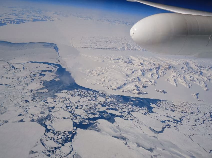
NASA's Multiple Altimeter Beam Experimental Lidar flew over Southwest Greenland's glaciers and sea ice to test a new method of measuring the height of Earth from space.
Credit: NASA/Tim Williams
New results from
NASA's MABEL campaign demonstrated that a photon-counting technique will allow researchers to track the melt or growth of Earth's frozen regions.
When a high-altitude aircraft flew over the icy Arctic Ocean and the snow-covered terrain of Greenland in April 2012, it was the first polar test of a new laser-based technology to measure the height of Earth from space.
Aboard that aircraft flew the
Multiple Altimeter Beam Experimental Lidar (MABEL), which is an airborne test bed instrument for
NASA's ICESat-2 satellite mission slated to launch in 2017.
Both MABEL and
ICESat-2's ATLAS instrument are photon counters – they send out pulses of green laser light and time how long it takes individual light photons to bounce off Earth's surface and return.
That time, along with ATLAS' exact position from an onboard GPS, will be plugged into computer programs to tell researchers the elevation of Earth's surface – measuring change to as little as the width of a pencil.
This kind of photon-counting technology is novel for satellites; from 2003 to 2009, ICESat-1's instrument looked at the intensity of a returned laser signal, which included many photons.
So getting individual photon data from MABEL helps scientists prepare for the vast amounts of elevation data they'll get from ICESat-2.
"Using the individual photons to measure surface elevation is a really new thing," said
Ron Kwok, a senior research scientist at NASA's Jet Propulsion Laboratory in Pasadena, Calif.
"It's never been done from orbiting satellites, and it hasn't really been done much with airborne instruments, either."
ICESat-2 is tasked with measuring elevation across Earth's entire surface, including vegetation and oceans, but with a focus on change in the frozen areas of the planet, where scientists have observed dramatic impacts from climate change.
There, two types of ice – ice sheets and sea ice – reflect light photons in different patterns.
Ice sheets and glaciers are found on land, like Greenland and Antarctica, and are formed as frozen snow and rain accumulates.
Sea ice, on the other hand, is frozen seawater, found floating in the Arctic Ocean and offshore of Antarctica.
MABEL's 2012 Greenland campaign was designed to observe a range of interesting icy features, said
Bill Cooke, MABEL's lead scientist at NASA's Goddard Space Flight Center in Greenbelt, Md.
With the photon counts from different surfaces, other scientists could start analyzing the data to determine which methods of analyzing the data allow them to best measure the elevation of Earth's surface.
MABEL, short for "Multiple Altimeter Beam Experimental Lidar," serves as an ICESat-2 simulator.
Credit: NASA /Kelly Brunt
"We wanted to get a wide variety of target types, so that the science team would have a lot of data to develop algorithms," Cooke said.
"This was our first real dedicated science mission."
The flights over the ocean near Greenland, for example, allowed researchers to demonstrate that they can measure the height difference between open water and sea ice, which is key to determining the ice thickness.
MABEL can detect enough of the laser light photons that bounce off Earth surface and return to the instrument, and programs can then make necessary elevation calculations, Cooke said.
 |
| Bill Cooke |
"Part of what we're doing with MABEL is to demonstrate ICESat-2's instrument is going to have the right sensitivity to do the measurements," Cooke said. "You can do this photon counting if you have enough photons."
In an article recently published in the Journal of Atmospheric and Oceanic Technology, Kwok and his colleagues showed how to calculate elevation from MABEL data, and do so over different types of ice – from open water, to thin, glassy ice, to the snow-covered ice.