Friday, November 30, 2012

Nasa Mars Rover Curiosity: Atmospheric radiation may be lower than expected,


Mars' thin atmosphere -- and lack of magnetic field -- lets many charged and neutral particles through. 

Curiosity rover's Radiation Assessment Detector (RAD) instrument will check to see if astronauts could work there.

Credit: Southwest Research Institute.

Why the surprise? So far, it was expected that Mars, having a very thin atmosphere and no magnetosphere, would represent a rather harsh environment when it comes to cosmic radiation.

On Earth, the atmosphere and magnetosphere work as a powerful shield protecting terrestrial life. With the Martian atmosphere being only 1 % of the terrestrial one, it seems there was reason to be concerned.

These presumed high radiation levels would pose a significant threat to potential future astronauts travelling to Mars.

Moreover, they might be able to prevent the existence of any sort of Earth-like lifeforms on the planet.

Hassler was reluctant to reveal further details as he believes additional verification of the data needs to be carried out.

As the first radiation measurements ever carried out on the surface of another celestial body suggest, the radiation levels Curiosity detected on Mars are about the same as those experienced by crews aboard the International Space Station.

NASA's Space Launch System: Langley Wind Tunnel Test

NASA's Space Launch System buffet model in NASA's Langley Researcher Center's Transonic Dynamics Tunnel. 

The SLS is America's next heavy-lift launch vehicle that will provide an entirely new capability for science and human exploration beyond Earth's orbit. 

Image credit: NASA/LaRC

NASA Messenger: Mercury Water Ice Encourages Search for Alien Life


All of the larger polar deposits are located on the floors or walls of impact craters. 

Deposits farther from the pole are seen to be concentrated on the north-facing sides of craters. Image released Nov. 28, 2012. 

CREDIT: NASA/Johns Hopkins University Applied Physics Laboratory/ Carnegie Institution of Washington/ National Astronomy and Ionosphere Center, Arecibo Observatory 

The discovery of huge amounts of water ice and possible organic compounds on the heat-blasted planet Mercury suggests that the raw materials necessary for life as we know it may be common throughout the solar system, researchers say.

Mercury likely harbors between 100 billion and 1 trillion metric tons of water ice in permanently shadowed areas near its poles, scientists analyzing data from NASA's Messenger spacecraft announced Thursday (Nov. 29).

Life on sun-scorched Mercury remains an extreme longshot, the researchers stressed, but the new results should still put a spring in the step of astrobiologists around the world.

"The more we examine the solar system, the more we realize it's a soggy place," Jim Green, the director of NASA's Planetary Science Division, said during a press conference today.

"And that's really quite exciting, because that means the amount of water that we have here on Earth — that was not only inherent when it was originally formed but probably brought here — that water and other volatiles were brought to many other places in the solar system," Green added.

"So it really bodes well for us to continue on the exploration, following the water and its signs throughout the solar system." [Latest Mercury Photos from Messenger]

Thursday, November 29, 2012

3D printers could use Moon rocks to make supplies, say scientists

Future Moon colonists should be able to use lunar rocks to create tools or spare parts, according to a study.
US researchers have used a 3D printer to make small objects out of melted simulated lunar rocks.

They say the technique could help future missions to minimise the weight and the expense of carrying materials into space as a digital file would be enough.

But one expert says such a printer would have to be extremely precise.

In 2010, Nasa asked a team from Washington State University to see whether it was possible to use lunar rocks for 3D printing.

It supplied the researchers with simulated Moon rocks, or lunar regolith simulant, containing silicon, aluminium, calcium, iron and magnesium oxides.

Many hundreds of kilograms of Moon rocks were collected during Nasa missions, but the scientists did not use them because they are considered a national treasure in the US.

Lunar regolith simulant is commonly used for research purposes at Nasa.

"It sounds like science fiction, but now it's really possible," said Prof Amit Bandyopadhyay, the lead author of the study, published in the Rapid Prototyping Journal.

His team created simple 3D shapes by sending a digital file or scan to a printer which then built the items layer by layer out of melted lunar regolith, fed via a carefully controlled nozzle to form a shape. The process is known as "additive manufacturing".

A laser was used to melt the material.

"As long as you can have additive manufacturing set up, you may be able to scoop up and print whatever you want. It's not that far-fetched," said Prof Bandyopadhyay.

The research demonstrates the latest advances in 3D printing technology, which is already in use in medicine, fashion, car manufacturing and other industries.

Giant black hole in tiny galaxy puzzles astronomers

Astronomers have spotted an enormous black hole - the second most massive ever - but it resides in a tiny galaxy.

The galaxy NGC 1277, just a quarter the size of our own Milky Way, hosts a black hole 4,000 times larger than the one at the Milky Way's centre.

A report in Nature shows it has a mass some 17 billion times that of our Sun.

The surprise finding is hard to reconcile with existing models of black hole growth, which hold that they evolve in tandem with host galaxies.

Getting to grips with just how large black holes are is a tricky business - after all, since they swallow light in their vicinities, they cannot be seen.

Instead, astronomers measure the black holes' "sphere of influence" - the gravitational effects they have on surrounding gas and stars.

In the Milky Way, it is possible to observe individual stars as they orbit Sagittarius A, our own local black hole, to guess its mass.

But for the 100 or so far more distant black holes whose masses have been estimated, astronomers have made average measurements of associated stars' speeds - their "velocity dispersion".

On a hunt for the Universe's largest black holes, astronomers using the Hobby-Eberly Telescope in the US state of Texas undertook a survey that brought in a haul of nearly 900 host galaxies.
 
'Big jigsaw'
But Remco van den Bosch, then at the University of Texas at Austin, and his colleagues were surprised to find that some of the largest black holes were to be found in small galaxies.

Among them was NGC 1277, 220 million light years away in the constellation Perseus, which happens to appear also in a high-resolution Hubble Space Telescope image, helping the researchers to refine their computer models.

"We make a model of the galaxy and compute all the possible stellar orbits," Dr Van den Bosch, who is now at the Max Planck Institute for Astronomy in Germany, explained.

Like a big jigsaw, we try to put those orbits together to reproduce that galaxy so it has the same stellar velocities we measure. "

What the team found was that the NGC 1277 black hole was enormous - as large as our Solar System, and comprising some 14% of the entire galaxy's mass.

"The only way to you can actually make those high dispersions in the centre is by having that really big black hole, there's really no other way around it," Dr Van den Bosch said.

What is more, the team have five other small-galaxy candidates that, with the help of more data, could disprove the rule that big black holes only happen in big galaxies.

But NGC 1277 is stranger still, and could help advance our theories of how black holes evolve in the first place.

"This galaxy seems to be very old," Dr Van den Bosch said. "So somehow this black hole grew very quickly a long time ago, but since then that galaxy has been sitting there not forming any new stars or anything else.

"We're trying to figure out how this happens, and we don't have an answer for that yet. But that's why it's cool."

Wednesday, November 28, 2012

Microsatellites aim to fill weather-data gap

The COSMIC radio-sounding satellites are ageing but may set the stage for a commercial system.

Credit: OSC/UCAR

Some orbiting satellites look up at the stars and most point down towards Earth but the satellites of the Constellation Observing System for Meteorology, Ionosphere and Climate (COSMIC) look sideways, across the curving horizon.

There, dozens of satellites that are part of the Global Positioning System (GPS) pop in and out of view at the edge of the planet. By tracking their radio signals, COSMIC can provide atmospheric data that enhance weather forecasts and climate models.

But the fleet, launched six years ago at a cost of US$100 million, is nearing the end of its life, with one satellite of the original six already defunct.

At a three-day workshop last month at the University Corporation for Atmospheric Research (UCAR) in Boulder, Colorado, researchers hailed the US–Taiwanese COSMIC as a pioneer and discussed plans for a commercial successor: a network of 24 micro­satellites dubbed the Community Initiative for Cellular Earth Remote Observation (CICERO).

Researchers say that the programme could help to address a gap in atmospheric data as the United States struggles to meet a 2016 launch date for the first spacecraft in its expensive Joint Polar Satellite System (JPSS).

The radio-sounding technique that both COSMIC and CICERO use is a “disruptive technology”, says Rick Anthes, a COSMIC scientist and former president of UCAR. “The impact is huge — especially the impact for the cost.”

GPS radio signals, picked up by Earth-bound receivers in everything from mobile phones to missiles, yield precise position information. But COSMIC puts them to a different use.

The signals travel at a known rate, but skimming through the planet’s atmosphere and back out to space bends the signals and delays them; COSMIC uses the length of the delay to measure the atmospheric density, which can provide information on changing characteristics such as temperature and moisture levels (see ‘Bending for data’). It makes many hundreds of these radio-occultation measurements each day.

Tuesday, November 27, 2012

Pluto: It's Atmosphere More Extensive Than Thought

Artist’s impression of how the surface of Pluto might look. The image shows patches of pure methane on the surface.

CREDIT: ESO/L. Calçada

A new simulation of Pluto's upper atmosphere shows that it extends so far from the planet that stray molecules may be deposited on its largest moon, Charon.

The new model predicts that Pluto's atmosphere can extend as far as 6,456 miles (10,390 kilometers) into space, or about 4.5 times the diameter of Pluto. That's more than halfway to Charon.

"That is amazing, from my perspective," said Justin Erwin, the lead author of the paper and a Ph.D. student at the University of Virginia.

Researchers combined two previously known models of Pluto's atmosphere to better estimate the escape rate of molecules into space. Their refinement made a big difference.

"Our [calculated escape rate] is a little bit smaller, but the small change in the escape rate causes a large change in the structure of the atmosphere," Erwin added.

Erwin's supervisor at the University of Virginia, Robert Johnson, was a co-author of the paper reporting the findings, which was published on the preprint site Arxiv and has been submitted to the journal Icarus for publication.

Fire and ice
Pluto's tenuous atmosphere is mainly composed of methane, nitrogen and poisonous carbon monoxide that likely comes from ice on the dwarf planet's surface. The size of the atmosphere changes as Pluto moves closer and farther from the sun in its elliptical orbit.

When Pluto swings near the sun, the sun's heat evaporates the ice and gases slowly escape into space. This process continues until Pluto moves away and the sun's heat fades. Then, the ice builds up until Pluto approaches the sun again.

Pluto's last close approach to the sun was in 1989. That is considered a fairly recent event, because it takes 248 years for the dwarf planet to orbit the sun once.

Researchers are trying to refine the escape rate of the gases ahead of the arrival of NASA's New Horizons probe at Pluto in 2015, so that the spacecraft knows what to look for.

For the new calculations, Erwin's team used previously published research from themselves and other scientists.

Destination Pluto: NASA's New Horizons Mission in Pictures

Saturn's moons Mimas and Tethys bear 'Pac-Man' signatures

Saturn's moons Mimas (left) and Tethys are now both known to exhibit the curious temperature patterns.

Astronomers have seen that the temperature of Saturn's moon Tethys has hotter regions uncannily like the 1980s arcade game character Pac-Man.

A similar feature was spotted in 2010 on Mimas, another Saturnian moon.

A report in Icarus suggests the effect is due to high-energy electrons bombarding the sides of the moons that face their direction of orbital travel.

That compacts the surfaces to a hard, icy texture that does not heat or cool as rapidly as the unaffected surface.

Thermal images of both moons were obtained by the Cassini-Huygens mission, launched in 1997 to study the Saturn system in detail.

The temperatures seen by the spacecraft are distinctly chilly - the warmest parts of Tethys were at - 183C, but inside the "mouth" of the Pac-Man shape it was 15C cooler still.

At the time of the finding of the first Pac-Man shape on Mimas, scientists were unsure what might be the cause, theorising that differing surface textures probably played a role.

The existence of another such shape nearby has cemented the idea that fast-moving electrons are responsible.

"Finding a second Pac-Man in the Saturn system tells us that the processes creating these 'Pac-Men' are more widespread than previously thought," said Carly Howett, of the Southwest Research Institute in Texas and lead author of the study.

"The Saturn system - and even the Jupiter system - could turn out to be a veritable arcade of these characters," she said.

ESA budget cuts a major blow to CarbonSat - Earth climate science

CarbonSat Image Credit: Astrium

ESA’s funding shortfall is bad news for CarbonSat, a mission aiming to track atmospheric carbon dioxide.
For Europe’s space chiefs, the outcome of last week’s European Space Agency (ESA) budget negotiations was better than expected, given the continent’s economic troubles.

But for Volker Liebig, ESA’s head of Earth Observation programmes (EOP), there is a sting in the agreement.

The multi-year budget that member states approved — which falls some €2 billion (US$2.6 billion) short of ESA’s proposed spending of about €12 billion — could force him to postpone or cancel a mission aimed at pinning down the mysterious carbon sinks that are slowing the rise of greenhouse gases in Earth’s atmosphere.

Ahead of the budget negotiations in Naples, Italy, on 20–21 November, Liebig had hoped to secure around €1.25 billion for new research satellites.

With France, Italy and Spain contributing much less than expected, he received €1.9 billion for Earth-observation projects.

But €808 million has already been allocated for a new generation of weather-forecasting satellites, leaving him with little more than €1 billion for research missions.

“We have to discuss with scientists in the next few weeks what to do,” Liebig says. “But we will not be able to develop all the science satellites we wanted to.”

Most vulnerable, he says, is a planned €250-million climate-change mission scheduled for launch in about 2018.

One of the two contenders for the mission, CarbonSat, would map atmospheric concentrations of carbon dioxide and methane at high-enough resolution to investigate a long-standing puzzle: why only about half of the CO2 emitted by human activities remains in the atmosphere.

Scientists assume that the rest is absorbed largely by the oceans and plants, but ground-based monitoring stations are too few and far apart to pinpoint the sinks.

Satellites could fill in the gaps in the picture, but in April ESA lost contact with Envisat, the one satellite providing such data (see Nature 484, 423–424; 2012).

Neither Japan’s existing Greenhouse Gases Observing Satellite nor NASA’s Orbiting Carbon Observatory-2 (OCO-2), scheduled for launch in 2014, will map greenhouse-gas concentrations in as much detail as CarbonSat, which would survey the whole globe with a resolution of 4 square kilometres.

“The information that it would collect is essential for developing, implementing, and monitoring greenhouse-gas-emission policies,” says atmospheric physicist David Crisp of NASA’s Jet Propulsion Laboratory in Pasadena, California, who is the science team leader of OCO-2. “A timely launch of this satellite should be among the highest priorities of ESA”.

CarbonSat’s competitor for ESA funding, FLEX, would also help to pin down carbon sinks, by measuring the faint fluorescence generated by plants during photosynthesis — a measure of how efficiently they absorb carbon.

“The last thing we want to do is to destroy the forests or whatever is absorbing almost half of the CO2 that we are emitting,” says Crisp.

“Wouldn’t it be good to know where these processes are occurring?”

NASA Ames: Space Habitation - Colony Artwork from the 1970s

Credit: NASA Ames and scans by David Brandt-Erichsen.

According to the Ames Space centre:
"Humanity has the power to fill outer space with life."

"Today our solar system is filled with plasma, gas, dust, rock, and radiation -- but very little life; just a thin film around the third rock from the Sun."

"We can change that. In the 1970's Princeton physicist Gerard O'Neill with the help of NASA Ames Research Center and Stanford University showed that we can build giant orbiting spaceships and live in them."

"These orbital space colonies could be wonderful places to live; about the size of a California beach town and endowed with weightless recreation, fantastic views, freedom, elbow-room in spades, and great wealth."

"In time, we may see hundreds of thousands of orbital space settlements in our solar system alone. Building these settlements will be an evolutionary event in magnitude similar to, if not greater than, ocean-based Life's colonization of land half a billion years ago."


Read the full article on Human Space Settlement here

Three space colony summer studies were conducted at NASA Ames in the 1970s and a number of artistic renderings of the concepts were made.


These have been scanned and are available here as small, medium, large, and publication quality jpeg images.


Dark Matter Detection: Running Out of Places to Hide


Astronomers using the W. M. Keck Observatory, the Hubble Space Telescope, and other telescopes on Mauna Kea have studied a giant filament of dark matter in 3D for the first time. Image released Oct. 17. 2012.

CREDIT: Image by ESA; additional elements by K. Teramura, Univ. Hawaii Institute for Astronomy

The hiding spots for the particles making up dark matter are narrowing, and the answer to this cosmic mystery could come within the next three or four years, scientists say.

Dark matter is an elusive substance that is invisible and almost never detected, except by its gravitational pull. Yet astronomers say it likely makes up a quarter of the entire universe and dwarfs the amount of normal matter (galaxies, stars and planets) out there in space.

Just last week, particle physics discovery from the Large Hadron Collider in Switzerland cast doubt on a theory called supersymmetry, which predicts the existence of particles that are among the leading candidates for dark matter.

That finding limited the types of supersymmetric particles that can exist, but didn't take the supersymmetry explanation off the table completely.

And supersymmetric particles are just one of a number of theorized particles that might account for dark matter. Searches for these and other undiscovered particles have been underway for decades, though none have been detected so far. [Twisted Physics: 7 Mind-Blowing Findings]

"I think we're looking in enough different ways that unless it's something that we just haven't thought of at all yet, it seems to me we're very likely to find it within the next decade," said Dan Bauer, a physicist at the Fermi National Accelerator Laboratory in Illinois working on one of the experiments, called CDMS.

ESA ESO VLT Image: Thor's Helmet Nebula

Credit: B Bailleul/ESO

The Thor’s Helmet Nebula, also known as NGC 2359, lies in the constellation of Canis Major (The Great Dog).

The helmet-shaped nebula is around 15 000 light-years away from Earth and is over 30 light-years across.

The helmet is a cosmic bubble, blown as the wind from the bright, massive star near the bubble's centre sweeps through the surrounding molecular cloud.

The glowing gas is heated by the energetic radiation provided by the central star.

Many different colours, originating from different elements in the gas, are also visible, as well as many dust clouds.

ESO VLT Chile
"With the VLT, ALMA and the future E-ELT, ESO is entering a new era, one that not even the initial bold dreams of ESO’s founding members could have anticipated. To all of you that have made it possible, on behalf of ESO, thank you!" concludes Tim de Zeeuw.

Space Debris: New ESA European Radar Installation

A new radar designed to test methods for finding orbital debris that can be hazardous to space navigation has been installed near Santorcaz in Spain.

The radar will be used to develop future debris warning services, helping to improve safety for ESA's European satellite operators

Monday, November 26, 2012

NASA Terra Satellite- Cloud Streets Off of the Aleutian Islands

Image Credit: NASA/GSFC/Jeff Schmaltz/MODIS Land Rapid Response Team

Strong winds polished the snow of southwestern Alaska and stretched marine stratocumulus clouds into long, parallel streets in early January, 2012.

After crossing Bristol Bay, the winds scraped the clouds across the tall volcanic peaks of the Aleutian Islands.

As the wind impacted the immobile mountains, the airflow became turbulent, swirling in symmetric eddies and carving intricate patterns into the clouds on the leeward side of the islands.

At the top of this image, the bright white color indicates a thick layer of snow overlying the land of southwestern Alaska.

The pristine white is broken by the rugged Ahklun Mountain Range in the east, which is partially covered by a bank of clouds.

Off the coast of Alaska, sea ice floats in Bristol Bay, cracked and chipped by the flow of the waters which lie underneath. A few cloud streets – parallel lines of clouds – can be seen in the far northwest over land.

The clouds increase over the sea ice and become thick over open water, where row upon row of clouds lie close in perfectly parallel formation.

The Aleutian Islands stretch from northeast to southwest across the image. Sea ice, which is bright white here, lies on the windward side of the islands. A few of the tallest volcanic peaks can be seen rising from the icy islands.

The character of the cloud streets change as they impact the Aleutians, especially near the center of the image, where two rows of beautifully symmetric swirls of eddies in the clouds stretch across the sky.

These swirling formations are known as von Karman vortex streets. This true-color image was captured by the Moderate Resolution Imaging Spectroradiometer (MODIS) aboard NASA’s Terra satellite on January 11, 2012.

ALMA Antenna: Final North American Antenna Delivered


After an odyssey of design and construction stretching across more than a decade, North America has delivered the last of the 25, 12-meter-diameter dish antennas that comprise its share of antennas for the international ALMA telescope.

This is an important milestone in the construction of an observatory that astronomers are already using to open up a "final frontier" of the spectrum of invisible light to high-resolution exploration.

ALMA, the Atacama Large Millimeter/submillimeter Array, stretches across more than 75 square miles of a high-altitude desert plain in northern Chile.

The scientific communities of North America, Europe, and East Asia have banded together to build the observatory, and are sharing its $1.3 billion cost.

When completed, ALMA will have a total of 66 antennas, 25 from North America, 25 from Europe, and 16 from East Asia.


Completed Final North American ALMA Antenna.

CREDIT: General Dynamics SATCOM Technologies, Bill Johnson.

"We are delighted to deliver this final ALMA antenna from North America," said Mark McKinnon, the North American ALMA Project Director at the National Radio Astronomy Observatory (NRAO) in Charlottesville, Virginia.

"It is a real testimony to the production team that we were able to overcome many technical challenges to complete the antenna delivery."

Faint radio waves, emitted naturally by gas and dust in space, will be detected and measured by the antennas, with the measurements then processed by a supercomputer to generate images as detailed as would come from a single dish that was miles across.

These images will give astronomers insights into previously invisible or unresolved processes of planet, star, and galaxy evolution, both nearby and across cosmic time.

The technique of combining radio telescopes to form a virtual, high-resolution instrument has been in use for decades. For example, the National Science Foundation's (NSF's) recently revitalized Very Large Array (VLA) in New Mexico uses this technique to explore the Universe as seen in centimeter-wavelength light. ALMA is the first VLA-scale array to attempt this feat at millimeter and submillimeter wavelengths.

For these shorter wavelengths, an antenna dish surface must be more precise, able to maintain its parabolic curvature to within the thickness of a human hair amidst harsh conditions at the 16,500-foot high ALMA site.

Funding to build the 25, 110-ton North American antennas was provided by the NSF, in the largest single procurement in the history of the foundation's astronomy division.

Associated Universities, Inc. (AUI) managed the contract, while NRAO oversaw the integration and testing of the antennas, which were manufactured and assembled by General Dynamics SATCOM Technologies.

Each antenna's pedestal and dish structure components were shipped separately to the ALMA site, and assembled in a huge hanger building, also built by General Dynamics.

Once ALMA is completed next year, it is expected to serve as a state-of-the-art radio telescope for thirty years or more.

"This is a very exciting time in astronomy," commented Tony Beasley, NRAO Director. "With ALMA we are taking perhaps the greatest leap in observing power in the history of the science."

Ethan Schreier, president of AUI, said "ALMA is the largest, most expensive ground-based astronomy project ever attempted, and a model for international science collaborations.

The success of the partnership is manifest in the achievement of this milestone, but will be even more evident in the legacy of discovery and understanding that is going to emerge over the coming years, as tomorrow's eager astronomers get their hands on this fantastic telescope."

NASA - Commander Kelly on the Station

Credit: NASA

NASA astronaut Scott Kelly, Expedition 25 flight engineer, is pictured in the ESA Cupola of the International Space Station on Oct. 14, 2010.

NASA has selected Kelly for a one-year mission aboard the station in 2015.

Kelly will join Russian cosmonaut Mikhail Kornienko on a mission that will collect scientific data important to future human exploration of our solar system.

The goal of the yearlong expedition aboard the orbiting laboratory is to understand better how the human body reacts and adapts to the harsh environment of space.

Data from the 12-month expedition will help inform current assessments of crew performance and health and will determine better and validate countermeasures to reduce the risks associated with future exploration as NASA plans for missions around the moon, an asteroid and ultimately Mars.

TerraSAR-X satellite: The Santorini volcano expands

Credit: DLR

British researchers have used images acquired by the German Aerospace Center (Deutsches Zentrum für Luft- und Raumfahrt; DLR) TerraSAR-X satellite to create a map showing changes in the Santorini archipelago. 

The cause of the deformation is the Santorini volcano located beneath the archipelago.

In some places, the Kameni Islands inside the flooded caldera have risen by eight to 14 centimetres. 

The breadth of the caldera as a whole has increased by about 14 centimetres since early 2011. 

In the analysis of the radar data, the red and yellow shading shows the areas where the ground has risen the most. The main island of Thira is unaffected by the deformation, thus appearing blue.

Glasses are rattling on the shelves and the ground is rumbling - since January 2011 the earth under the Santorini volcano has been stirring.

Most of the time, it is barely noticeable, but every now and then the inhabitants notice small tremors jolting the volcanic archipelago. Nearly circular, and seemingly carved from stone, the submerged caldera is located in the Aegean Sea.

"It was clear to the local people that something was happening with the volcano - but it wasn't until we saw, among other things, the images from the TerraSAR-X radar satellite that we realised that molten rock was pooling beneath the volcano," says British scientist Juliet Biggs from the University of Bristol.

Images acquired by the German Aerospace Center's (Deutsches Zentrum fur Luft- und Raumfahrt; DLR) satellite show the entire archipelago not just rising, but also expanding.

It has been 3600 years since a powerful explosion formed the large caldera. Since then, a new vent has been gradually forming in the middle of this basin, where today the Kameni islands protrude from the water.

The volcano last erupted in 1950 and then fell dormant again, so the scientists from Oxford and Bristol were all the more surprised when the inhabitants started reporting tremors.

"Tour guides, who often visit the volcano with tourists on a daily basis, told me there was an increase in the quantity of strong smelling gas being released by the summit," explains PhD student Michelle Parks. "The colour of the sea had changed as well."

AEOLDOS: Glasgow Uni and Clyde Space set to put brakes on SpaceDebris


Engineers at the University of Glasgow and Clyde Space Ltd have developed a practical solution to the increasing problem of space debris. Millions of pieces of 'space junk' are orbiting the Earth as a side-effect of human exploration and exploitation of space.

The pieces range from tiny fragments of bigger objects such as rocket boosters to full-sized pieces of now-defunct equipment. Working satellites and spacecraft can be damaged by collisions with debris, which can travel at velocities of several kilometres per second.

The problem is compounded by every collision which creates more debris in turn; in 2009, the collision of a non-operational Russian communications satellite and a working US satellite created more than 700 pieces of debris.

Dr Patrick Harkness of the University's School of Engineering has led the development of the Aerodynamic End Of Life Deorbit System, or AEOLDOS, to help ensure that objects sent into space in future can be removed from orbit at the end of their operational cycle.

AEOLDOS is lightweight, foldable 'aerobrake' which can be added to small satellites known as CubeSats before they are launched into low Earth orbit.

Once the satellite has reached the end of its operational life the lightweight aerobrake, made from a thin membrane supported by tape measure-like struts, springs open to generate aerodynamic drag against the extremely thin upper atmosphere that still exists in near-Earth space.

As the satellite falls out of orbit the aerodynamic effects increase, causing the satellite to harmlessly burn up during its descent.

This ensures that it does not become another piece of potentially harmful space debris.Glasgow-based SME Clyde Space, which builds small and micro spacecraft systems, is working with Dr Harkness to apply AEOLDOS technology to the CubeSats it provides to customers all over the world.

CubeSats are used for space-related research projects and generally sent into space as secondary payloads on larger launch vehicles.

Dr Harkness said: "It's only been 55 years since Sputnik, the first man-made satellite, was sent into orbit, but since then we've managed to make made quite a mess of the space around our planet.

The rate at which we're putting objects into orbit is accelerating each year, which is why it's vital for us to take more control over how they can be removed from orbit once they have served their purpose.

CubeSats are currently aimed at lower orbits than is necessarily desired to ensure they will re-enter the Earth's atmosphere within 25 years in order to meet official recommendations set by the United Nations Office for Outer Space Affairs.

This can curtail the full scientific potential of CubeSats, but AEOLDOS gives users much more control over the end of their project's life and could enable missions to take place at much higher altitudes because they know we can always produce the drag they will need to dispose of the spacecraft in time."

The tape measure deployment system has been developed by Malcolm McRobb, also from the School of Engineering.

Coiling the tapes stores energy within them, which can be released years later to deploy the membrane. Mr. McRobb believes that AEOLDOS has applications beyond space debris control.

He explained: "The technology could be used to enable solar sailing missions, where spacecraft can manoeuvre using the pressure of sunlight.

Or it could form the basis of deployable antennae, increasing the sensitivity of small, low-powered spacecraft.We expect that another year to 18 months of development will see the AEOLDOS system available for commercial use through our licensing agreement with Clyde Space.

After we have demonstrated that the technology can work in space, we are looking forward to designing these new and exciting applications for the device."

Craig Clark of Clyde Space said: 'Clyde Space is widely recognized for developing key technologies and products that enable more advanced CubeSat missions, and AEOLDOS is another key innovation that will enable more spacecraft missions in the future.

The team at the University of Glasgow have been able to solve critical problems relating to the drag sail deployment with effective, innovative solutions and we're sure that this development will be used on many small satellite missions in the future as we aim to reduce the problem of space junk for the next generation of space users.'

The development of the AEOLDOS project is part of the University of Glasgow's Space Glasgow Research Cluster, which draws together researchers from across the College of Science and Engineering to work on pioneering space-related projects.

NASA Hubble Image: Eyes a Loose Spiral Galaxy

The Hubble Space Telescope has spotted the spiral galaxy ESO 499-G37, seen here against a backdrop of distant galaxies, scattered with nearby stars.

The galaxy is viewed from an angle, allowing Hubble to reveal its spiral nature clearly.

The faint, loose spiral arms can be distinguished as bluish features swirling around the galaxy’s nucleus.

This blue tinge emanates from the hot, young stars located in the spiral arms.

The arms of a spiral galaxy have large amounts of gas and dust, and are often areas where new stars are constantly forming.

The galaxy’s most characteristic feature is a bright elongated nucleus. The bulging central core usually contains the highest density of stars in the galaxy, where typically a large group of comparatively cool old stars are packed in this compact, spheroidal region.

One feature common to many spiral galaxies is the presence of a bar running across the center of the galaxy. These bars are thought to act as a mechanism that channels gas from the spiral arms to the center, enhancing the star formation.

Image Credit: NASA/Hubble

Sunday, November 25, 2012

NASA Mars HiRise Image: MRO Captures Dark Sand Cascades

They might look like trees on Mars, but they're not.

Groups of dark brown streaks have been photographed by the Mars Reconnaissance Orbiter on melting pinkish sand dunes covered with light frost.

The above image was taken near the North Pole of Mars.

At that time, dark sand on the interior of Martian sand dunes became more and more visible as the spring Sun melted the lighter carbon dioxide ice.

When occurring near the top of a dune, dark sand may cascade down the dune leaving dark surface streaks -- streaks that might appear at first to be trees standing in front of the lighter regions, but cast no shadows.

Objects about 25 centimeters across are resolved on this image spanning about one kilometer.

Close ups of some parts of this image show billowing plumes indicating that the sand slides were occurring even when the image was being taken.

Saturday, November 24, 2012

BAE Systems releases details of their Hybrid tank - GCV


BAE Systems has released an infographic outlining the features of its hybrid Ground Combat Vehicle (GCV).

A joint venture between BAE Systems and Northrop Grumman with other partners, the GCV proposal is part of a US Army competition to replace the Bradley Fighting Vehicle, which entered service in 1981.

NASA Mars HiRISE Image: Starburst Spider Terrain

Credit: NASA Mars HiRISE

Mars’ seasonal cap of carbon dioxide ice (dry ice) has eroded many beautiful terrains as it sublimates (goes directly from ice to vapor) every spring.

In this region we see troughs that form a starburst pattern.

In other areas these radial troughs have been referred to as “spiders,” simply because of their shape.

In this region the pattern looks more dendritic as channels branch out numerous times as they get further from the center.

The troughs are believed to be formed by gas flowing beneath the seasonal ice to openings where the gas escapes, carrying along dust from the surface below.

The dust falls to the surface of the ice in fan-shaped deposits.

You can find more images here

Friday, November 23, 2012

NASA Mars Rover Curiosity: Traces of Past Life Discovered?

As space fans anticipate news of organic molecules from the Mars Curiosity rover – cryptically teased by the mission's chief scientist, John Grotzinger, there's one man who is even more excited than most.

Former NASA researcher Gilbert Levin says that a positive sign of organics by Curiosity would confirm his claim that NASA has already seen evidence for life on Mars – from an experiment called Labeled Release that went to the Red Planet aboard the Viking mission.

If Curiosity has found evidence for organics, as many are hoping, "that removes the last barrier to my interpretation of the Labeled Release results, and leaves us free and clear", Levin reported.

Though the prospect of new Curiosity findings have set the internet abuzz, nobody from NASA has yet said publicly what they are: Grotzinger has refused to elaborate journalists, to a presentation scheduled for the American Geophysical Union annual meeting in San Francisco, which begins on 3 December.

ESA DLR: EDRS space network ready to go ahead

The design of Europe’s data relay satellite system – EDRS - has been completed and approved.

This marks the moment when it moves ahead with a green light from its first customer, the Global Monitoring for Environment and Security initiative from the European Union (GMES).

EDRS will provide a telecommunications network that is fast, reliable and seamless, making real-time information from satellites available on demand.

EDRS will be the first commercially operated data relay system to deliver services to the Earth observation community.

It is being built through a Public–Private Partnership (PPP) between ESA and Astrium Services, using payloads carried by two satellites in geostationary orbit, hovering 36 000 km above the Equator, where their speed matches Earth’s rotation.

Data transmitted from satellites in lower orbits to either of these EDRS payloads can then be relayed to the ground.

The payload includes a laser terminal developed by TESAT of Germany to transmit up to 1.8 gigabits per second over distances in excess of 40 000 km, between the lower satellites and EDRS in geostationary orbit.

A design review board of senior members from ESA, Astrium and the DLR German Aerospace Center approved the entire system design: from the satellites to the support that will be required from the ground.

The industrial organisation is fully in place with all subcontracts negotiated and ESA’s partner Astrium Services ready to begin production.

“EDRS is a fantastic breakthrough for Europe, from the innovative laser communication terminal technology, which is the heart of EDRS, to the provision of operational services by 2014 through a PPP that combines the best from European space companies with the national and European space institutions,” says Magali Vaissiere, director of ESA’s Telecommunications and Integrated Applications Directorate.

The first of the two EDRS payloads will be carried on the Eutelsat-EB9B satellite, starting operation in 2014, built by Astrium and positioned at 9°E over the Equator.

The second satellite, planned for launch in 2016, will carry the second EDRS payload as well as the Hylas-3 payload from the UK’s Avanti Communications. This satellite will be built by Germany’s OHB using the SmallGEO platform, currently under development by OHB under ESA contract.

NASA GEOS-5 Image: Global Atmospheric Aerosols

Image courtesy NASA Goddard Space Flight Center.

High-resolution global atmospheric modeling run on the Discover supercomputer at the NASA Center for Climate Simulation at Goddard Space Flight Center, provides a unique tool to study the role of weather in Earth’s climate system.

The Goddard Earth Observing System Model, Version 5 (GEOS-5) is capable of simulating worldwide weather at resolutions of 10 to 3.5 kilometers (km).

This portrait of global aerosols was produced by a GEOS-5 simulation at a 10-kilometer resolution. Dust (red) is lifted from the surface, sea salt (blue) swirls inside cyclones, smoke (green) rises from fires, and sulfate particles (white) stream from volcanoes and fossil fuel emissions.

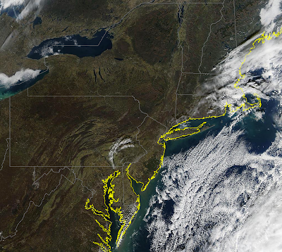
NASA Terra Satellite Image: Capturing the Fading Colours of the US Fall

NASA Terra Satellite Image; 21 November 2012. There is still a lot of Autumn Fall colours showing over southern Virginia.

Thursday, November 22, 2012

Dwarf planet Makemake: Confirmation that it lacks atmosphere

Dwarf planet Makemake is about two thirds of the size of Pluto, and travels around the Sun in a distant path that lies beyond that of Pluto but closer to the Sun than Eris, the most massive known dwarf planet in the Solar System.

Previous observations of chilly Makemake have shown it to be similar to its fellow dwarf planets, leading some astronomers to expect its atmosphere, if present, to be similar to that of Pluto.

However, the new study now shows that, like Eris, Makemake is not surrounded by a significant atmosphere.

The team, led by Jose Luis Ortiz (Instituto de Astrofisica de Andalucia, CSIC, Spain), combined multiple observations using three telescopes at ESO's La Silla and Paranal observing sites in Chile - the Very Large Telescope (VLT), New Technology Telescope (NTT), and TRAPPIST (TRAnsiting Planets and PlanetesImals Small Telescope) - with data from other small telescopes in South America, to look at Makemake as it passed in front of a distant star.

"As Makemake passed in front of the star and blocked it out, the star disappeared and reappeared very abruptly, rather than fading and brightening gradually. This means that the little dwarf planet has no significant atmosphere," says Jose Luis Ortiz.

"It was thought that Makemake had a good chance of having developed an atmosphere - that it has no sign of one at all shows just how much we have yet to learn about these mysterious bodies. Finding out about Makemake's properties for the first time is a big step forward in our study of the select club of icy dwarf planets."

Makemake's lack of moons and its great distance from us make it difficult to study, and what little we do know about the body is only approximate.

The team's new observations add much more detail to our view of Makemake - determining its size more accurately, putting constraints on a possible atmosphere and estimating the dwarf planet's density for the first time.

They have also allowed the astronomers to measure how much of the Sun's light Makemake's surface reflects - its albedo. Makemake's albedo, at about 0.77, is comparable to that of dirty snow, higher than that of Pluto, but lower than that of Eris.

It was only possible to observe Makemake in such detail because it passed in front of a star - an event known as a stellar occultation.

These rare opportunities are allowing astronomers for the first time to find out a great deal about the sometimes tenuous and delicate atmospheres around these distant, but important, members of the Solar System, and providing very accurate information about their other properties.

Occultations are particularly uncommon in the case of Makemake, because it moves in an area of the sky with relatively few stars.

Accurately predicting and detecting these rare events is extremely difficult and the successful observation by a coordinated observing team, scattered at many sites across South America, ranks as a major achievement.

"Pluto, Eris and Makemake are among the larger examples of the numerous icy bodies orbiting far away from our Sun," says Jose Luis Ortiz.

"Our new observations have greatly improved our knowledge of one of the biggest, Makemake - we will be able to use this information as we explore the intriguing objects in this region of space further."

Wednesday, November 21, 2012

Water, Footprints or Life on Mars? NASA Says; Maybe not!

NASA downplayed Wednesday talk of a major discovery by its Martian rover after remarks by the mission chief raised hopes it may have unearthed evidence life once existed on the Red Planet.

Excitement is building over soon-to-be-released results from NASA's Curiosity rover, which is three months into a two-year mission to determine if Mars has ever been capable of supporting microbial life.

Its Sample Analysis at Mars (SAM) instruments have been sending back information as it hunts for compounds such as methane, as well as hydrogen, oxygen and nitrogen, that would mean life could once have existed there.

In an interview aired Tuesday, lead mission investigator John Grotzinger hinted at something major but said there would be no announcement for several weeks.

"We're getting data from SAM," he said. "This data is gonna be one for the history books. It's looking really good."

A spokesman for NASA's Jet Propulsion Laboratory, which is managing the project, appeared to pour cold water Wednesday on the hopes of space enthusiasts looking forward to an earth-shattering discovery.

"John was delighted about the quality and range of information coming in from SAM during the day a reporter happened to be sitting in John's office last week. He has been similarly delighted by results at other points during the mission so far," spokesman Guy Webster reported.

"The scientists want to gain confidence in the findings before taking them outside of the science team. As for history books, the whole mission is for the history books," Webster said.

Scientists do not expect Curiosity to find aliens or living creatures but they hope to use it to analyze soil and rocks for signs the building blocks of life are present and may have supported life in the past.

The $2.5 billion Curiosity rover, which landed in Gale Crater on Mars on August 6, 2012, also aims to study the Martian environment to prepare for a possible human mission there in the coming years.

US President Barack Obama has vowed to send humans to the planet by 2030.

ESA GOCE Satellite: Comes Closer to Earth to work

A European gravity-mapping satellite orbiting about 340 miles closer to Earth than any other satellite is to be brought even lower and closer, officials say.

The Gravity Field and Steady-State Ocean Circulation Explorer, or GOCE, launched by the European Space Agency in 2009, is to have its orbit lowered by 12 miles to improve the resolution of its data-gathering instruments, ESA officials said.

Controllers have been reducing the height of the satellite's orbit by about 1,000 feet a day since August.

The move is not without its risks, as GOCE will have to fight atmospheric drag to stay aloft and maintain the stability needed to measure Earth's gravity.

But the improvement in accuracy should be worth it, the ESA said.

"The science benefit that you get from decreasing the altitude and thereby increasing the spatial resolution of the data, and also the precision of what you can measure, is quite spectacular," mission manager Rune Floberghagen told the BBC.

"We will get about a 35 percent increase in the quality of the data."

GOCE is equipped with super-sensitive instrumentation to measure the subtle variations in the pull of gravity across the surface of the Earth.

ESA: France, Germany seek Ariane Launcher compromise

ESA, the European Space Agency, made progress towards a deal on budget and a successor to the Ariane 5 rocket at talks on space strategy.

Initiating a two-day meeting against a backdrop of financial constraints, many countries backed proposals to keep spending unchanged over the next few years.

Major ESA players France and Germany seemed to be bridging their differences over a future launcher.

"There is quite a strong view in the council in favour of flat cash," UK's Willetts told reporters, referring to a stable budget.

"My starting point is that... it ought to be able to be possible in tough times to deliver the efficiency savings," he said. "Other major players have made that point as well but as of this moment it is unresolved."

ESA spokesman Franco Bonacina said "progress has been made on certain things" but "for the problematic issues... the debate is still going on", and the outcome would come on Wednesday.

The meeting -- the first at ministerial level in four years -- takes place against a backdrop of money worries, a fast-shifting satellite market and the growing strength of the US private sector in near-Earth space.

ESA Director General Jean-Jacques Dordain told AFP last week he hoped ministers would back a three-year budget of 12 billion euros ($15 billion) but added he would be happy with "something around 10 billion euros".

It would mean a roughly stable budget compared with current levels, "but given the current situation, this is not small beer", he said.

One of the most crucial agenda items is deciding on a future rocket launcher to replace the ageing Ariane 5.

The new rocket should provide more flexible launch options for the swiftly-changing satellite market and wean itself off the 120 million euros a year that the Ariane 5 needs from ESA's budget each year.

France is pushing for a smaller, sleeker Ariane 6, which would require investment of about four billion euros, culminating in a maiden flight in 2021 if all goes well.

But industrialists fear that this timescale is way too long and will give the advantage to fleet-footed rivals in commercial satellite launches.

They prefer a German-backed option, an Ariane 5 ME (for "Midlife Evolution"), which would be ready by 2017 at a putative cost of two billion euros.

"I think we are probably heading towards a compromise, or some kind of understanding, between France and Germany," Willetts told reporters, in remarks confirmed by two other sources.

Those sources said the hoped-for compromise would approve the "ME" and over the next two years study how its technology could be used in a future Ariane 6 to save money.

Weighing on many minds is not just belt-tightening but also the rise of the US private sector.

The bogeyman is the US firm SpaceX, which last month sent an unmanned freighter, Dragon, to the International Space Station under a NASA initiative to delegate resupply missions to private corporations.

In other developments in Naples, ministers agreed to launch a dialogue with the European Union about clarifying what each institution will do in space.

The risk of turf battles has emerged with the EU's Galileo satellite navigation system, which is being launched by ESA.

ESA is an intergovernmental agency that is legally separate from the 27-nation EU; two of its members (Norway and Switzerland) are not part of the EU club, and Canada is an associate member.

Critical Mobility Technologies: CSA's New Lunar Rover - YouTube


Peter Visscher of Ontario Drive and Gear presented this talk titled "Critical Mobility Technologies to Enable Long Term Lunar Surface Activity" at the 2012 Canadian Space Summit. Peter's company has been funded by the Canadian Space Agency (CSA) to work on lunar rover prototypes.

NASA has expressed an interest in using one of Canada's lunar rovers for a future moon mission as part of a Canadian contribution.

Tuesday, November 20, 2012

NASA Mars Curiosity: Latest data discovery points to historic discovery. Breathable Air?

Self portrait of NASA's Mars rover Curiosity, which arrived at the Red Planet on Aug. 6, 2012. 

Credit: Andrew Bodrov/ 360Cities.net/ NASA/ JPL/ Caltech.

Curiosity is living up to its name. The NASA rover currently wheeling itself around Mars has apparently sent back some very interesting data from the Red Planet in the form of a soil sample that shows ... well, something. From the sounds of it, something big. But for now at least, that's all anyone is willing to say.

Scientists at NASA's Jet Propulsion Laboratory in Pasadena are keeping their lips sealed for the time being while they run additional tests to make sure the discovery holds up. That, however, hasn't stopped one of the mission's leaders from speculating loudly that it'll be one that rewrites at least some of what we know about the universe.

"This data is gonna be one for the history books," John Grotzinger, the rover mission's principal investigator, told NPR last week for a the buzz-inciting segment that aired today. "It's looking really good."

What we do know is that the data comes from a soil sample analyzed by the rover's Sample Analysis at Mars instrument, an on-board lab known as SAM, so if the data holds up to further testing it appears possible, and perhaps likely, that it is a discovery of an element on Mars previously thought not to exist on the Red Planet.

Of course, the reason that NASA is keeping the potential find (mostly) under wraps is because it may turn out to be nothing but a false alarm, something that's happened before to the mission. NPR explains:

So why doesn't Grotzinger want to share his exciting news? The main reason is caution. Grotzinger and his team were almost stung once before. When SAM analyzed an air sample, it looked like there was methane in it, and at least here on Earth, some methane comes from living organisms. But Grotzinger says they held up announcing the finding because they wanted to be sure they were measuring Martian air, and not air brought along from the rover's launchpad at Cape Canaveral.

"We knew from the very beginning that we had this risk of having brought air from Florida. And we needed to diminish it and then make the measurement again," he says. And when they made the measurement again, the signs of methane disappeared.

But the simple fact Grotzinger is willing to talk so openly (and excitedly) about the possible discovery in light of the past let downs would seem to suggest he has a good deal of confidence that it will hold up to further testing.

No word on exactly how long it will take before we learn more, but Grotzinger told NPR that it will likely take "several weeks" before he and his team are ready to go public. Until then, feel free to take to the comments with your best (or worst) guesses.

ESA GOCE: Earth's Gravity Fields Mapped

ESA's GOCE mission has delivered the most accurate model of the 'geoid' ever produced.

Red corresponds to points with higher gravity, and blue to points with lower gravity.

CREDIT: ESA/HPF/DLR

It's already made the most detailed map yet of Earth's gravity fields, but the GOCE satellite isn't done yet: Now it's lowering its orbit and coming closer and closer to Earth to make an even better map.

The data from the GOCE satellite, which is run by the European Space Agency, is enormously useful to scientists like geologists and climatologists and to oil companies and government officials.

Measurements from the satellite have been used to visualize what is going on beneath the Earth's surface.

The satellite has helped track the underground movement of lava and detect changes in gravity caused by melting glaciers, and it has produced the first high-resolution map of the boundary between Earth's crust and mantle.

But by lowering its orbit from 158 miles (255 kilometers) high to 146 miles (235 km) — which is about 310 miles (500 km) lower than most Earth observation satellites — the satellite is likely to produce an even more accurate map, the ESA says.

The satellite is descending by about 980 feet (300 meters) a day and is slated to reach its new orbit in February.

The maps produced by the satellite show the "geoid" of the Earth, a hypothetical surface around the planet at which the planet's gravitational pull is the same everywhere.

Anything with mass has a gravity field that attracts objects toward it. The strength of this gravity field depends on the mass of the body. Since Earth's mass isn't spread out evenly, its gravity field is stronger in certain areas than in others.

The strength of Earth's gravity varies depending on the depth of an ocean trench or height of a mountain, as well as the density of material.

Over dense areas, where gravity is stronger, the geoid moves away from the real surface of the planet, and where gravity is weaker, the geoid moves closer to the real surface.

Mapping this geoid helps to conduct precise measurements of ocean circulation, sea-level changes and the mass of polar ice sheets, according to an ESA news release.

Stargazer Captures Striking Nebula View

Bill Snyder captured Sh2-112 Sharpless on July 29, 2012 from his home observatory in Connellsville, Pa.

He used a TMB130mm telescope equipped with an Apogee U8300 camera, as well as an Atlas EQG mount and several filters to view SH2-112.

The total exposure time to capture this image was more than 18 hours.

CREDIT: Bill Snyder, Astrophotography

NASA MAVEN: Instrument delivered to study Martian atmosphere

NASA's MAVEN (Mars Atmosphere and Volatile EvolutioN) mission has reached its next stage, with the delivery of a remote sensor instrument to the company assembling the spacecraft, Lockheed Martin.

The Remote Sensing package will help scientists find clues as to how Mars lost its atmosphere.

The instrument, which was designed and is being built by the University of Colorado’s Laboratory for Atmospheric and Space Physics (CU/LASP) under a NASA contract, will now be integrated into the spacecraft.

"Three of the big milestones in an instrument builder's life are the day you get selected to fly on a mission, the day you deliver the instrument to the spacecraft to get ready for launch, and the day that it gets where it's going and data starts flowing back from space," said Mark Lankton, Remote Sensing package program manager from CU/LASP.

The delivery is important because it means the team are shifting from assembling the basic spacecraft to focusing on getting the science instruments installed.

Bruce Jakosky, professor of geological sciences and associate director of science at CU’s Laboratory for Atmospheric and Space Physics

Bruce Jakosky, MAVEN principal investigator from CU/LASP adds "This is a major step toward getting us to launch and then getting the science return from the mission."