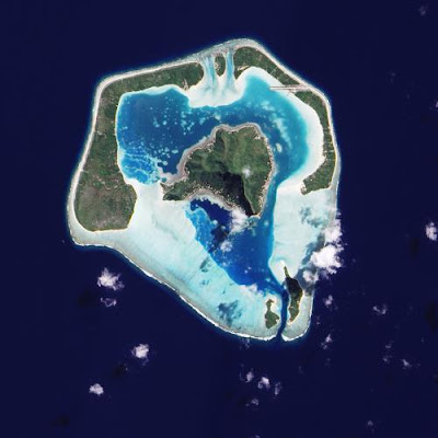
A satellite image of Maupiti, one of the Society Islands, which is on its way to becoming an atoll. Submerged reef appears in pale blue.
Credit: NASA EARTH OBSERVATORY
The three different formations of South Pacific coral-reef islands have long fascinated geologists.
Tahiti's coral forms a "fringing" reef, a shelf growing close to the island's shore.
The "barrier" reefs of Bora Bora are separated from the main island by a calm lagoon.
Finally, an "atoll," such as Manuae, appears as a ring of coral enclosing a lagoon with no island at its center.
The question of how reefs develop into these shapes over evolutionary time produced an enduring conflict between two hypotheses, one from British naturalist Charles Darwin and the other from Canadian geologist Reginald Daly.
In a paper (see PDF) recently published in the journal Geology, researchers at MIT and Woods Hole Oceanographic Institution (WHOI) use modern measurements and computer modeling to resolve this old conundrum.
Darwin proposed that fringing reefs, barrier reefs and atolls reflect different stages in a dramatic process that occurs as an island sinks into the ocean floor—the ultimate fate of all of the world's volcanic ocean islands.
As young volcanic rock cools and is carried away from a volcanic "hot spot" by the movement of tectonic plates, an island sinks as much as a few millimeters per year.
As the island sinks, resident coral reefs on the island flanks grow upward toward the sea surface. The living coral organisms up top, and their symbiotic algae, get enough sunlight to keep pace with the sinking of the island.
As the coral grows upward and the island sinks down, a fringing reef progresses to a barrier reef, and eventually to a signature atoll.
However, Darwin's reef theory can't explain the trajectories of all volcanic ocean-island systems, as MIT/WHOI graduate student Michael Toomey and collaborators Taylor Perron, the Cecil and Ida Green Assistant Professor of Geology at MIT, and Andrew Ashton, a coastal geomorphologist at WHOI, discovered.
The Hawaiian Islands, they realized, show a different kind of progression: For example, the researchers found fringing reef where they expected to find no reef development and drowned barrier reefs where they expected living barrier reefs.
"Those islands are just not sinking into atolls like the Society Islands," Toomey says, "so we wanted to develop a model to explain these differences."
More information: "Profiles of ocean island coral reefs controlled by sea-level history and carbonate accumulation rates" geology.gsapubs.org/content/early/2013/05/09/G34109.1.full.pdf+html
Credit: NASA EARTH OBSERVATORY
The three different formations of South Pacific coral-reef islands have long fascinated geologists.
Tahiti's coral forms a "fringing" reef, a shelf growing close to the island's shore.
The "barrier" reefs of Bora Bora are separated from the main island by a calm lagoon.
Finally, an "atoll," such as Manuae, appears as a ring of coral enclosing a lagoon with no island at its center.
The question of how reefs develop into these shapes over evolutionary time produced an enduring conflict between two hypotheses, one from British naturalist Charles Darwin and the other from Canadian geologist Reginald Daly.
In a paper (see PDF) recently published in the journal Geology, researchers at MIT and Woods Hole Oceanographic Institution (WHOI) use modern measurements and computer modeling to resolve this old conundrum.
 |
| Charles Darwin |
As young volcanic rock cools and is carried away from a volcanic "hot spot" by the movement of tectonic plates, an island sinks as much as a few millimeters per year.
As the island sinks, resident coral reefs on the island flanks grow upward toward the sea surface. The living coral organisms up top, and their symbiotic algae, get enough sunlight to keep pace with the sinking of the island.
As the coral grows upward and the island sinks down, a fringing reef progresses to a barrier reef, and eventually to a signature atoll.
 |
| Michael Toomey |
The Hawaiian Islands, they realized, show a different kind of progression: For example, the researchers found fringing reef where they expected to find no reef development and drowned barrier reefs where they expected living barrier reefs.
"Those islands are just not sinking into atolls like the Society Islands," Toomey says, "so we wanted to develop a model to explain these differences."
More information: "Profiles of ocean island coral reefs controlled by sea-level history and carbonate accumulation rates" geology.gsapubs.org/content/early/2013/05/09/G34109.1.full.pdf+html


