Showing posts with label CRISM. Show all posts

Wednesday, November 5, 2014

NASA Mars Curiosity Rover discovers mineral match

This image shows the first holes drilled by NASA's Mars rover Curiosity at Mount Sharp. 

The loose material near the drill holes is drill tailings and an accumulation of dust that slid down the rock during drilling. 

Credit: NASA/JPL-Caltech/MSSS

Reddish rock powder from the first hole drilled into a Martian mountain by NASA's Curiosity rover has yielded the mission's first confirmation of a mineral mapped from orbit.

"This connects us with the mineral identifications from orbit, which can now help guide our investigations as we climb the slope and test hypotheses derived from the orbital mapping," said Curiosity Project Scientist John Grotzinger, of the California Institute of Technology in Pasadena.

Curiosity collected the powder by drilling into a rock outcrop at the base of Mount Sharp in late September.

The robotic arm delivered a pinch of the sample to the Chemistry and Mineralogy (CheMin) instrument inside the rover.

This sample, from a target called "Confidence Hills" within the "Pahrump Hills" outcrop, contained much more hematite than any rock or soil sample previously analyzed by CheMin during the two-year-old mission.

Hematite is an iron-oxide mineral that gives clues about ancient environmental conditions from when it formed.

In observations reported in 2010, before selection of Curiosity's landing site, a mineral-mapping instrument on NASA's Mars Reconnaissance Orbiter (MRO) provided evidence of hematite in the geological unit that includes the Pahrump Hills outcrop.

The landing site is inside Gale Crater, an impact basin about 96 miles (154 kilometers) in diameter with the layered Mount Sharp rising about three miles (five kilometers) high in the center.

"We've reached the part of the crater where we have the mineralogical information that was important in selection of Gale Crater as the landing site," said Ralph Milliken of Brown University,

Providence, Rhode Island. He is a member of Curiosity's science team and was lead author of that 2010 report in Geophysical Research Letters identifying minerals based on observations of lower Mount Sharp by the orbiter's Compact Reconnaissance Imaging Spectrometer for Mars (CRISM).

"We're now on a path where the orbital data can help us predict what minerals we'll find and make good choices about where to drill. Analyses like these will help us place rover-scale observations into the broader geologic history of Gale that we see from orbital data."

This image from NASA's Curiosity rover shows a sample of powdered rock extracted by the rover's drill from the "Confidence Hills" target, the first rock drilled after Curiosity reached the base of Mount Sharp in September 2014. 

Credit: NASA/JPL-Caltech/MSSS

Much of Curiosity's first year on Mars was spent investigating outcrops in a low area of Gale Crater called "Yellowknife Bay," near the spot where the rover landed.

The rover found an ancient lakebed. Rocks there held evidence of wet environmental conditions billions of years ago that offered ingredients and an energy source favourable for microbial life, if Mars ever had microbes.

Clay minerals of interest in those rocks at Yellowknife Bay had not been detected from orbit, possibly due to dust coatings that interfere with CRISM's view of them.

The rover spent much of the mission's second year driving from Yellowknife Bay to the base of Mount Sharp.

The hematite found in the first sample from the mountain tells about environmental conditions different from the conditions recorded in the rocks of Yellowknife Bay.

The rock material interacted with water and atmosphere to become more oxidized.

The rocks analyzed earlier also contain iron-oxide minerals, mostly magnetite. One way to form hematite is to put magnetite in oxidizing conditions.

The latest sample has about eight percent hematite and four percent magnetite. The drilled rocks at Yellowknife Bay and on the way to Mount Sharp contain at most about one percent hematite and much higher amounts of magnetite.

"There's more oxidation involved in the new sample," said CheMin Deputy Principal Investigator David Vaniman of the Planetary Science Institute in Tucson, Arizona.

This side-by-side comparison shows the X-ray diffraction patterns of two different samples collected from rocks on Mars by NASA's Curiosity rover. 

The images present data obtained by Curiosity's Chemistry and Mineralogy instrument (CheMin). 

At left is a pattern of data from analysis of the "Cumberland" rock target in the "Yellowknife Bay" area investigated by Curiosity in 2013. 

The pattern at right is from the "Confidence Hills" target that was the first rock drilled after Curiosity reached the base of Mount Sharp in September 2014. 

A label in the right image of the annotated view points out evidence for the mineral hematite in this rock. 

Credit: NASA/JPL-Caltech

The sample is only partially oxidized, and preservation of magnetite and olivine indicates a gradient of oxidation levels.

That gradient could have provided a chemical energy source for microbes.

The Pahrump HIlls outcrop includes multiple layers uphill from its lowest layer, where the Confidence Hills sample was drilled.

The layers vary in texture and may also vary in concentrations of hematite and other minerals.

The rover team is now using Curiosity to survey the outcrop and assess possible targets for close inspection and drilling.

This view shows the path and some key places in a survey of the "Pahrump Hills" outcrop by NASA's Curiosity Mars rover in autumn of 2014. The outcrop is at the base of Mount Sharp within Gale Crater. 

The mission's in-place investigation of the layered mountain began at the low edge of the Pahrump Hills outcrop, at the target "Confidence Hills." 

Curiosity collected a drilled sample of rock powder at that target in September 2014 and delivered portions of the powder into analytical instruments inside the rover. 

Then the mission began a "walkabout" of the outcrop, similar to the way field geologists on Earth walk across an outcrop to choose the best places on it to examine in detail. 

The dashed gold line indicates the path the rover drove during the walkabout. Names are shown for a few of the features visited and observed by the rover. 

Red dots indicate stops at the end of a day's drive. White dots indicate locations of stops made during the drives to collect observations of the Pahrump Hills outcrop. 

The mission completed the walkabout at the site labeled "Whale Rock," and the team is now examining the observations acquired during the walkabout to decide where to return for more detailed analysis. Credit: NASA/JPL-Caltech/MSSS

The mission may spend weeks to months at Pahrump Hills before proceeding farther up the stack of geological layers forming Mount Sharp.

Those higher layers include an erosion-resistant band of rock higher on Mount Sharp with such a strong orbital signature of hematite, it is called "Hematite Ridge."

The target drilled at Pahrump Hills is much softer and more deeply eroded than Hematite Ridge.

Another NASA Mars rover, Opportunity, made a key discovery of hematite-rich spherules on a different part of Mars in 2004.

That finding was important as evidence of a water-soaked history that produced those mineral concretions.

The form of hematite at Pahrump Hills is different and is most important as a clue about oxidation conditions. Plenty of other evidence in Gale Crater has testified to the ancient presence of water.

Thursday, June 26, 2014

Mars Rover Opportunity: Aluminum-Bearing Site on Mars

With its solar panels their cleanest in years, NASA's decade-old Mars Exploration Rover Opportunity is inspecting a section of crater-rim ridgeline chosen as a priority target due to evidence of a water-related mineral.

Orbital observations of the site by another NASA spacecraft, Mars Reconnaissance Orbiter, found a spectrum with the signature of aluminum bound to oxygen and hydrogen.

Researchers regard that signature as a marker for a mineral called montmorillonite, which is in a class of clay minerals called smectites.

Montmorillonite forms when basalt is altered under wet and slightly acidic conditions. The exposure of it extends about 800 feet (about 240 meters) north to south on the western rim of Endeavour Crater, as mapped by the orbiter's Compact Reconnaissance Imaging Spectrometer for Mars (CRISM).

"It's like a mineral beacon visible from orbit saying, 'Come check this out,'" said Opportunity Principal Investigator Steve Squyres, of Cornell University, Ithaca, New York.

Some of the most important findings from Opportunity's long mission came from combining CRISM and rover observations of a site about 2 miles (3 kilometers) farther north on the crater's western rim.

Rocks exposed there contain evidence for an iron-bearing smectite - called nontronite, as well as for montmorillonite.

That site yielded evidence for an ancient environment with water that would have been well-suited for use by microbes, if Mars had any billions of years ago.

Evidence that Opportunity may add about the geological context for different smectites could boost understanding about diversity and changes in ancient wet environments on Mars.

Opportunity reached the northern end of the montmorillonite-bearing exposure last month, at a high spot called "Pillinger Point." Opportunity's international science team chose that informal name in honor of Colin Pillinger (1943-2014).

Pillinger was the British principal investigator for the Beagle 2 project, which attempted to set a research lander on Mars a few weeks before Opportunity's January 2004 landing.

"Colin and his team were trying to get to Mars at the same time that we were, and in some ways they faced even greater challenges than we did," Squyres said.

"Our team has always had enormous respect for the energy and enthusiasm with which Colin Pillinger undertook the Beagle 2 mission. He will be missed."

Though selected as a science destination, Pillinger Point also offers a scenic vista from atop the western rim of Endeavour Crater, which is about 14 miles (22 kilometers) in diameter.

A color view of Pillinger Point from the rover's panoramic camera (Pancam) is available here

Initial measurements at this site with the element-identifying alpha particle X-ray spectrometer at the end of Opportunity's arm indicate that bright-toned veins in the rock contain calcium sulfate.

Scientists deduce this mineral was deposited as water moved through fractures on Endeavour's rim. The rover earlier found veins of calcium sulfate farther north along the rim.

As Opportunity investigates this site and sites farther south along the rim, the rover has more energy than usual.

"The solar panels have not been this clean since the first year of the mission," said Opportunity Project Manager John Callas of NASA's Jet Propulsion Laboratory, Pasadena, California.

"It's amazing, when you consider that accumulation of dust on the solar panels was originally expected to cause the end of the mission in less than a year."

"Now it's as if we'd been a ship out at sea for 10 years and just picked up new provisions at a port of call, topping off our supplies."

Both Opportunity and its rover twin, Spirit, benefited from sporadic dust-cleaning events in past years. However, on the ridge that Opportunity has been navigating since late 2013, winds have removed dust more steadily, day by day, than either rover has experienced elsewhere.

"It's easy to forget that Opportunity is in the middle of a Martian winter right now," said JPL's Jennifer Herman, power-subsystem engineer.

"Because of the clean solar arrays, clear skies and favorable tilt, there is more energy for operations now than there was any time during the previous three Martian summers. Opportunity is now able to pull scientific all-nighters for three nights in a row, something she hasn't had the energy to do in years."

The rover's signs of aging, including a stiff shoulder joint and occasional amnesia events, have not grown more troublesome in the past year, and no new symptoms have appeared.

Monday, February 10, 2014

NASA MRO HiRise: Flowing water on Mars difficult to prove

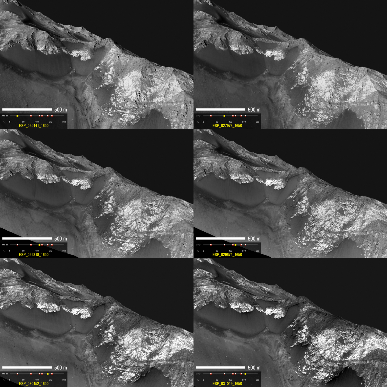
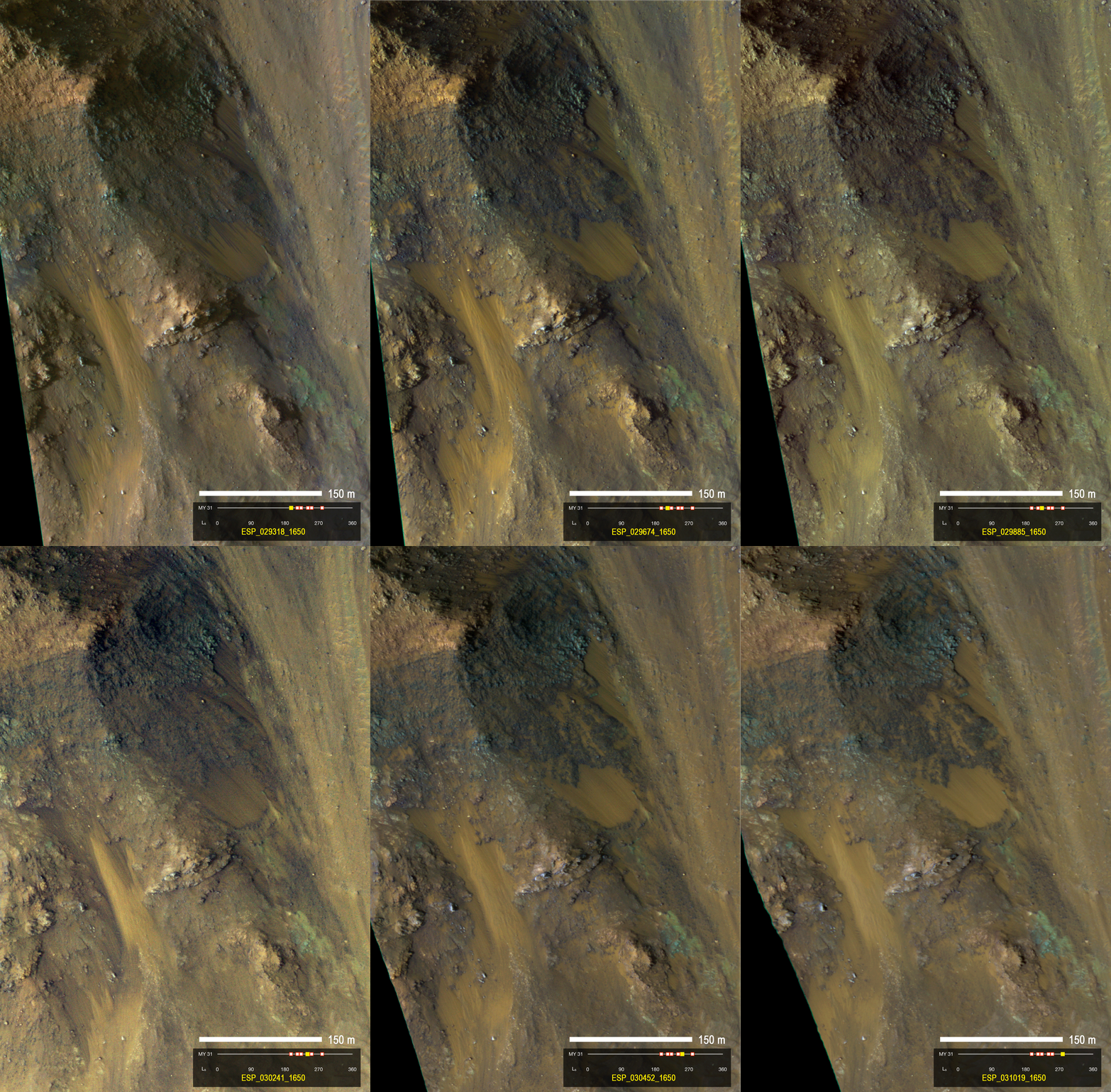
Dark flow-like features called Recurring Slope Lineae emanating from bedrock exposures at Palikir crater on Mars during southern summer. 

These flows are observed to form and grow during warm seasons when surface temperature is hot enough for salty ice to melt, and fade or completely disappear in cold season. 

Arrows point to bright, smooth fans left behind by flows. 

Credit: NASA/JPL

Martian experts have known since 2011 that mysterious, possibly water-related streaks appear and disappear on the planet's surface.

Georgia Institute of Technology Ph.D. candidate Lujendra Ojha discovered them while an undergraduate at the University of Arizona.

Lujendra Ojha
These features were given the descriptive name of recurring slope lineae (RSL) because of their shape, annual reappearance and occurrence generally on steep slopes such as crater walls.

Ojha has been taking a closer look at this phenomenon, searching for minerals that RSL might leave in their wake, to try to understand the nature of these features: water-related or not?

Ojha and Georgia Tech Assistant Professor James Wray looked at 13 confirmed RSL sites using Compact Reconnaissance Imaging Spectrometer for Mars (CRISM) images.

They didn't find any spectral signature tied to water or salts. But they did find distinct and consistent spectral signatures of ferric and ferrous minerals at most of the sites.

The minerals were more abundant or featured distinct grain sizes in RSL-related materials as compared to non-RSL slopes.

"We still don't have a smoking gun for existence of water in RSL, although we're not sure how this process would take place without water," said Ojha.

"Just like the RSL themselves, the strength of the spectral signatures varies according to the seasons. The signatures are stronger when it's warmer and less significant when it's colder."

The research team also notes that the lack of water-related absorptions rules out hydrated salts as a spectrally dominant phase on RSL slopes.

For example, ferric sulfates have been found elsewhere on Mars and are a potent antifreeze.

If such salts are present in RSL, then they must be dehydrated considerably under exposure to the planet's conditions by the time CRISM observes them in the mid-afternoon.

Dark elongated streaks called Recurring Slope Lineae observed in HiRISE images of Mars. 

The RSL form on sun facing slopes during warm season and fade during cold season. 

Credit: NASA/JPL

The findings were recently published in Geophysical Research Letters, and the Georgia Tech duo's newest paper, published in the journal Icarus, indicates that predicting where RSL will appear is, at best, a guessing game.

Ojha, Wray, and several Arizona-based colleagues looked at every image gathered by the High Resolution Imaging Science Experiment (HiRISE) from March to October of 2011.

They hunted for areas that were ideal locations for RSL formation: areas near the southern mid-latitudes on rocky cliffs. They found 200, but barely any of them had RSL.

"Only 13 of the 200 locations had confirmed RSL," said Ojha. "There were significant differences in abundance and size between sites, indicating that additional unknown factors such as availability of water or salts may play a crucial role in RSL formation."

Comparing their new observations with images taken in previous years, the team also found that RSL are much more abundant some years than others. Water on Mars today seems elusive at best – there one year, gone the next.

"NASA likes to 'follow the water' in exploring the red planet, so we'd like to know in advance when and where it will appear," Wray said.

"RSL have rekindled our hope of accessing modern water, but forecasting wet conditions remains a challenge."

Ojha and Wray are also among several co-authors on another RSL-related paper published this month in Nature Geoscience.

Saturday, May 18, 2013

NASA Mars Rover Opportunity examines clay clues in rock Esperance

The pale rock in the upper center of this image, about the size of a human forearm, includes a target called "Esperance," which was inspected by NASA's Mars Exploration Rover Opportunity.

Data from the rover's Alpha Particle X-ray Spectrometer (APXS) indicate that Esperance's composition is higher in aluminum and silica, and lower in calcium and iron, than other rocks Opportunity has examined in more than nine years on Mars.

Preliminary interpretation points to clay mineral content due to intensive alteration by water. 

Image Credit: NASA/JPL-Caltech/Cornell/Arizona State Univ.

NASA's senior Mars rover, Opportunity, is driving to a new study area after a dramatic finish to 20 months on "Cape York" with examination of a rock intensely altered by water.

The fractured rock, called "Esperance," provides evidence about a wet ancient environment possibly favorable for life.

Steve Squyres
The mission's principal investigator, Steve Squyres of Cornell University, Ithaca, N.Y., said, "Esperance was so important, we committed several weeks to getting this one measurement of it, even though we knew the clock was ticking."

The mission's engineers at NASA's Jet Propulsion Laboratory, Pasadena, Calif., had set this week as a deadline for starting a drive toward "Solander Point," where the team plans to keep Opportunity working during its next Martian winter.

"What's so special about Esperance is that there was enough water not only for reactions that produced clay minerals, but also enough to flush out ions set loose by those reactions, so that Opportunity can clearly see the alteration," said Scott McLennan of the State University of New York, Stony Brook, a long-term planner for Opportunity's science team.

This map of a portion of the western rim of Endeavour Crater on Mars shows the area where NASA's Mars Exploration Rover Opportunity worked for 20 months, "Cape York," in relation to the area where the rover team plans for Opportunity to spend its sixth Martian winter, "Solander Point."

This rock's composition is unlike any other Opportunity has investigated during nine years on Mars—higher in aluminum and silica, lower in calcium and iron.

The next destination, Solander Point, and the area Opportunity is leaving, Cape York, both are segments of the rim of Endeavour Crater, which spans 14 miles (22 kilometers) across.

The planned driving route to Solander Point is about 1.4 miles (2.2 kilometers).

Cape York has been Opportunity's home since the rover arrived at the western edge of Endeavour in mid-2011 after a two-year trek from a smaller crater.

"Based on our current solar-array dust models, we intend to reach an area of 15 degrees northerly tilt before Opportunity's sixth Martian winter," said JPL's Scott Lever, mission manager.

Scott McLennan
"Solander Point gives us that tilt and may allow us to move around quite a bit for winter science observations."

Northerly tilt increases output from the rover's solar panels during southern-hemisphere winter.

Daily sunshine for Opportunity will reach winter minimum in February 2014. The rover needs to be on a favourable slope well before then.

This mosaic of four frames shot by the microscopic imager on the robotic arm of NASA's Mars Exploration Rover Opportunity shows a rock target called "Esperance" after some of the rock's surface had been removed by Opportunity's rock abrasion tool, or RAT. 

Credit: NASA/JPL-Caltech /Cornell /USGS

The first drive away from Esperance covered 81.7 feet (24.9 meters) on May 14.

Three days earlier, Opportunity finished exposing a patch of the rock's interior with the rock abrasion tool.

The team used a camera and spectrometer on the robotic arm to examine Esperance.

JPL's Scott Lever, mission manager
The team identified Esperance while exploring a portion of Cape York where the Compact Reconnaissance Spectrometer for Mars (CRISM) on NASA's Mars Reconnaissance Orbiter (MRO) had detected a clay mineral.

Clays typically form in wet environments that are not harshly acidic.

For years, Opportunity had been finding evidence for ancient wet environments that were very acidic.

The CRISM findings prompted the rover team to investigate the area where clay had been detected from orbit.

There, they found an outcrop called "Whitewater Lake," containing a small amount of clay from alteration by exposure to water.

"There appears to have been extensive, but weak, alteration of Whitewater Lake, but intense alteration of Esperance along fractures that provided conduits for fluid flow," Squyres said.

"Water that moved through fractures during this rock's history would have provided more favourable conditions for biology than any other wet environment recorded in rocks Opportunity has seen."