Showing posts with label MastCam. Show all posts

Wednesday, November 26, 2014

NASA Mars Curiosity Rover: Mars Target Area 'Alexander Hills'

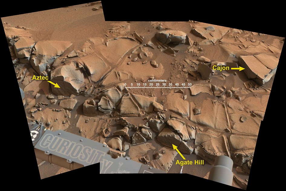
This view from the Mast Camera (Mastcam) on NASA's Curiosity Mars rover shows a swath of bedrock called "Alexander Hills," which the rover approached for close-up inspection of selected targets.

The mosaic of six Mastcam frames covers an area about 6 feet (2 meters) across.

It shows details within the workspace accessible using the rover's robotic arm from the rover's location when the view was acquired.

The component exposures were taken on Nov. 23, 2014, during the 817th Martian day, or sol, of Curiosity's work on Mars.

The colour has been approximately white-balanced to resemble how the scene would appear under daytime lighting conditions on Earth.

This annotated version shows the location of three targets selected for study, "Aztec," "Agate Hill" and "Cajon", and a 50-centimeter (20-inch) scale bar.

The location of Alexander Hills within the "Pahrump Hills" outcrop at the base of Mount Sharp is indicated on an earlier Mastcam vew

Friday, September 26, 2014

NASA Mars Rover Curiosity: Drill Pulls First Taste From Mars Mountain

This image from the Mars Hand Lens Imager (MAHLI) camera on NASA's Curiosity Mars rover shows the first sample-collection hole drilled in Mount Sharp, the layered mountain that is the science destination of the rover's extended mission.

Image Credit: NASA/JPL-Caltech/MSSS

NASA's Curiosity Mars rover has collected its first taste of the layered mountain whose scientific allure drew the mission to choose this part of Mars as a landing site.

Late Wednesday, Sept. 24, the rover's hammering drill chewed about 2.6 inches (6.7 centimeters) deep into a basal-layer outcrop on Mount Sharp and collected a powdered-rock sample.

Data and images received early Thursday at NASA's Jet Propulsion Laboratory, Pasadena, California, confirmed success of this operation.

The powder collected by the drilling is temporarily held within the sample-handling mechanism on the rover's arm.

"This drilling target is at the lowest part of the base layer of the mountain, and from here we plan to examine the higher, younger layers exposed in the nearby hills," said Curiosity Deputy Project Scientist Ashwin Vasavada of JPL.

"This first look at rocks we believe to underlie Mount Sharp is exciting because it will begin to form a picture of the environment at the time the mountain formed, and what led to its growth."


This southeastward-looking vista from the Mast Camera (Mastcam) on NASA's Curiosity Mars rover shows the "Pahrump Hills" outcrop and surrounding terrain seen from a position about 70 feet (20 meters) northwest of the outcrop.

Image Credit: NASA/JPL-Caltech/MSSS

Curiosity arrived Sept. 19 at an outcrop called "Pahrump Hills," which is a section of the mountain's basal geological unit, called the Murray formation.

Three days later, the rover completed a "mini-drill" procedure at the selected drilling target, "Confidence Hills," to assess the target rock's suitability for drilling.

A mini-drill activity last month determined that a rock slab under consideration then was not stable enough for full drilling, but Confidence Hills passed this test.

This image from the Mars Hand Lens Imager (MAHLI) camera on NASA's Curiosity Mars rover shows an example of a type of geometrically distinctive feature that researchers are using Curiosity to examine at a mudstone outcrop at the base of Mount Sharp.

Image Credit: NASA/JPL-Caltech/MSSS

The rock is softer than any of the previous three targets where Curiosity has collected a drilled sample for analysis.

Between the mini-drill test and the sample-collection drilling, researchers used tools on Curiosity's mast and robotic arm for close-up inspection of geometrically distinctive features on the nearby surface of the rock.

These features on the Murray formation mudstones are the accumulations of resistant materials. They occur both as discrete clusters and as dendrites, where forms are arranged in tree-like branching.

By investigating the shapes and chemical ingredients in these features, the team hopes to gain information about the possible composition of fluids at this Martian location long ago.

Read the full article here

Friday, August 15, 2014

NASA Curiosity Mars Rover Prepares for Fourth Rock Drilling

In this image from NASA's Curiosity Mars rover looking up the ramp at the northeastern end of "Hidden Valley," a pale outcrop including drilling target "Bonanza King" is at the center of the scene. 

The rover's Navcam captured this northward view on Aug. 4, 2014, from the valley's sandy floor.

Image Credit: NASA/JPL-Caltech

The team operating NASA's Curiosity Mars rover has chosen a rock that looks like a pale paving stone as the mission's fourth drilling target, if it passes engineers' evaluation.

They call it "Bonanza King."

It is not at the "Pahrump Hills" site the team anticipated the rover might reach by mid-August.

Unexpected challenges while driving in sand prompted the mission to reverse course last week after entering a valley where ripples of sand fill the floor and extend onto sloping margins.

However, the new target outcrop's brightness and its position within the area's geological layers resemble the Pahrump Hills outcrop.

This Aug. 14, 2012, image from the Mastcam on NASA's Curiosity Mars rover shows an outcrop that includes the "Bonanza King" rock under consideration as a drilling target. 

Raised ridges on the flat rocks are visible at right. 

Tread marks from a rover wheel are in the lower half.

Image Credit: NASA/JPL-Caltech/MSSS

"Geologically speaking, we can tie the Bonanza King rocks to those at Pahrump Hills. Studying them here will give us a head start in understanding how they fit into the bigger picture of Gale Crater and Mount Sharp," said Curiosity Deputy Project Scientist Ashwin Vasavada of NASA's Jet Propulsion Laboratory in Pasadena, California.

Mount Sharp is the mission's long-term science destination, offering a stack of layers holding evidence about environmental changes on ancient Mars.

The mountain rises from inside Gale Crater, where Curiosity landed in August 2012.

All three rocks the rover has drilled so far have been geologically associated with the crater floor, rather than the mountain.

Sample material pulled from the first two and delivered to Curiosity's onboard analytical laboratories in 2013 provided evidence for ancient environmental conditions favorable for microbial life.

A drilled sample from Bonanza King may add understanding about how environments varied and evolved.

This image from NASA's Curiosity Mars rover looks down the ramp at the northeastern end of "Hidden Valley" and across the sandy-floored valley to lower slopes of Mount Sharp on the horizon. 

The rover's Navigation Camera captured this southward view on Aug. 12, 2014, after exiting the valley. 

Image Credit: NASA/JPL-Caltech

Wednesday, July 16, 2014

NASA Mars Curiosity spots a heavy metal meteorite - Lebanon

2-meter wide iron meteorite dubbed “Lebanon,” as imaged by Curiosity’s ChemCam and Mastcam on May 25, 2014. 

Credit: NASA /JPL-Caltech /LANL /CNES /IRAP /LPGNantes /CNRS /IAS /MSSS

Talk about heavy metal! This shiny, lumpy rock spotted by NASA's Curiosity rover is likely made mostly of iron, and came from outer space!

It's an iron meteorite, similar to ones found in years past by Curiosity's forerunners Spirit and Opportunity, but is considerably larger than any of the ones the MER rovers came across… in fact, at 2 meters (6.5 feet) wide this may very well be the biggest meteorite ever discovered on Mars!

The picture above was made by combining high-resolution circular images (outlined in white) acquired with the Remote Micro-Imager (RMI) of Curiosity's ChemCam instrument with colour and context from the rover's Mastcam.

The images were taken on mission Sol 640 (May 25, 2014) and have been adjusted to simulate more Earth-like illumination.

Dubbed "Lebanon," the large meteorite has a smaller fragment lying alongside it, named "Lebanon B."

While iron meteorites are fairly common on Earth, on Mars they are by far the most common types of meteorites that have been discovered, if just for the sheer fact that they are highly resistant to erosion.

Original raw Mastcam (right) image of Lebanon and Lebanon B from Sol 640. 

Credit: NASA /JPL-Caltech /MSSS

Saturday, June 28, 2014

Mars Rover Curiosity Self-Portrait at 'Windjana' Drilling Site

Image Credit: NASA/JPL-Caltech/MSSS

NASA's Curiosity Mars rover used the camera at the end of its arm in April and May 2014 to take dozens of component images combined into this self-portrait where the rover drilled into a sandstone target called "Windjana."

The camera is the Mars Hand Lens Imager (MAHLI), which previously recorded portraits of Curiosity at two other important sites during the mission: "Rock Nest" and "John Klein"

Winjana is within a science waypoint site called "The Kimberley," where sandstone layers with different degrees of resistance to wind erosion are exposed close together.

The view does not include the rover's arm. It does include the hole in Windjana produced by the hammering drill on Curiosity's arm collecting a sample of rock powder from the interior of the rock.

 The hole is surrounded by grayish cuttings on top of the rock ledge to the left of the rover. The Mast Camera (Mastcam) atop the rover's remote sensing mast is pointed at the drill hole.

The Mastcam image of the drill hole from that perspective. The hole is 0.63 inch (1.6 centimeters) in diameter. The rover's wheels are 20 inches (0.5 meter) in diameter.

Most of the component frames of this mosaic view were taken during the 613th Martian day, or sol, of Curiosity's work on Mars (April 27, 2014).

 Frames showing Windjana after completion of the drilling were taken on Sol 627 (May 12, 2014). The hole was drilled on Sol 621 (May 5, 2014).

MAHLI was built by Malin Space Science Systems, San Diego. NASA's Jet Propulsion Laboratory, a division of the California Institute of Technology in Pasadena, manages the Mars Science Laboratory Project for the NASA Science Mission Directorate, Washington. JPL designed and built the project's Curiosity rover.


Tuesday, March 25, 2014

NASA Mars Curiosity rover finds sandstone variations

Sandstone layers with varying resistance to erosion are evident in this Martian scene recorded by the Mast Camera on NASA's Curiosity Mars rover on Feb. 25, 2014, about one-quarter mile (about 400 meters) from a planned waypoint called "the Kimberley." 

Credit: NASA /JPL-Caltech /MSSS

Variations in the stuff that cements grains together in sandstone have shaped the landscape surrounding NASA's Curiosity Mars rover and could be a study topic at the mission's next science waypoint.

On a journey with many months yet to go toward prime destinations on the lower slope of Mount Sharp, Curiosity is approaching a site called "the Kimberley."

Scientists on the team picked this location last year as a likely place to pause for investigation.

Its informal name comes from a northwestern Australia region known as the Kimberley. The Martian site's geological appeal, based on images taken from orbit, is that four types of terrain with different rock textures intersect there.

Ashwin Vasavada
"The orbital images didn't tell us what those rocks are, but now that Curiosity is getting closer, we're seeing a preview," said Curiosity Deputy Project Scientist Ashwin Vasavada of NASA's Jet Propulsion Laboratory, Pasadena, Calif.

"The contrasting textures and durabilities of sandstones in this area are fascinating.

While superficially similar, the rocks likely formed and evolved quite differently from each other."

The rocks that the Curiosity mission has studied most intensively so far are finer-grain mudstone, rather than sandstone.

The rover found evidence for an ancient lakebed environment favorable for microbial life when it analyzed sample powder drilled from mudstone last year in an area called "Yellowknife Bay."

The rover team is eager to inspect sandstone at the planned waypoint, now just 282 feet (86 meters) south of the rover.

The pause for investigations at this site might include time for collecting rock-sample material with the rover's drill, for delivery to the laboratory instruments inside the vehicle.

Thursday, February 20, 2014

Mars Curiosity Wheel Damage: Adds Reverse driving for wheel protection

This map shows the route driven and route planned for NASA's Curiosity Mars rover from before reaching "Dingo Gap", in upper right, to the mission's next science waypoint, "Kimberley" (formerly referred to as "KMS-9") -- in lower left. 

Credit: NASA/JPL-Caltech/Univ. of Arizona

Terrain that NASA's Curiosity Mars rover is now crossing is as smooth as team members had anticipated based on earlier images from orbit.

On Tuesday, Feb. 18, the rover covered 329 feet (100.3 meters), the mission's first long trek that used reverse driving and its farthest one-day advance of any kind in more than three months.

The reverse drive validated feasibility of a technique developed with testing on Earth to lessen damage to Curiosity's wheels when driving over terrain studded with sharp rocks.

However, Tuesday's drive took the rover over more benign ground.

Jim Erickson
"We wanted to have backwards driving in our validated toolkit because there will be parts of our route that will be more challenging," said Curiosity Project Manager Jim Erickson of NASA's Jet Propulsion Laboratory, Pasadena, Calif.

The rover team used images taken from orbit to reassess possible routes, after detecting in late 2013 that holes in the vehicle's aluminum wheels were accumulating faster than anticipated.

Getting to the chosen route, which appeared to be less hazardous for the wheels, required crossing a 3-foot-tall (1-meter-tall) dune. Curiosity crossed the dune on Feb. 9.

Erickson said, "After we got over the dune, we began driving in terrain that looks like what we expected based on the orbital data."

"There are fewer sharp rocks, many of them are loose, and in most places there's a little bit of sand cushioning the vehicle."

This look back at a dune that NASA's Curiosity Mars rover drove across was taken by the rover's Mast Camera (Mastcam) during the 538th Martian day, or sol, of Curiosity's work on Mars (Feb. 9, 2004). 

Credit: NASA /JPL-Caltech /MSSS

The mission's destinations remain the same: a science waypoint first and then the long-term goal of investigating the lower slopes of Mount Sharp, where water-related minerals have been detected from orbit.

The science waypoint, which may be where Curiosity next uses its sample-collecting drill, is an intersection of different rock layers about two-thirds of a mile (about 1.1 kilometers) ahead on the planned route.

This location, formerly called KMS-9 from when it was one of many waypoint candidates, is now called "Kimberley," for the geological mapping quadrant that contains it.

The mapping quadrant was named for the northwestern Australia region with very old rocks.

While the rover is headed for the Kimberley waypoint and during the time it spends doing science investigations there, the team will use orbital imagery to choose a path for continuing toward the long-term destination.

"We have changed our focus to look at the big picture for getting to the slopes of Mount Sharp, assessing different potential routes and different entry points to the destination area," Erickson said.

"No route will be perfect; we need to figure out the best of the imperfect ones."

Curiosity has driven 937 feet (285.5 meters) since the Feb. 9 dune-crossing, for a total odometry of 3.24 miles (5.21 kilometers) since its August 2012 landing.

Thursday, June 20, 2013

NASA Mars Curiosity Rover: Billion-Pixel Image Shows Mars in Stunning Detail

This is a reduced version of a mosaic from NASA's Mars rover Curiosity containing 1.3 billion pixels in the full-resolution version. 

It shows Curiosity at the "Rocknest" site, where the rover scooped up samples of windblown dust and sand, and was released on June 19, 2013. 

Viewers can explore this image with pan and zoom controls at http://mars.nasa.gov/bp1/.

CREDIT: NASA/JPL-Caltech/MSSS

A new 1.3-billion-pixel image from NASA’s Mars rover Curiosity allows viewers to zoom in and investigate part of the Red Planet in incredible detail.

The huge mosaic stitches together nearly 900 photos that the Curiosity rover took with some of its 17 cameras during the robot's exploration of Gale Crater on Mars, NASA officials said.

"It gives a sense of place and really shows off the cameras' capabilities," Bob Deen, of the Multi-Mission Image Processing Laboratory at NASA's Jet Propulsion Laboratory in Pasadena, Calif., said in a statement. "You can see the context and also zoom in to see very fine details."


Deen constructed the mosaic using 871 pictures from Curiosity's Mast Camera instrument and 25 black-and-white frames from the rover's navigation cameras.

The photos were taken between Oct. 5 and Nov. 16, 2012, officials said.

Curiosity landed inside the 96-mile-wide (154 km) Gale Crater on Aug. 5, 2012, kicking off a planned two-year surface mission to assess Mars' past and present potential to host microbial life.

In addition to its 17 cameras, Curiosity also carries 10 different science instruments to aid its quest.

The six-wheeled robot has already checked off its primary goal. Mission scientists announced in March that a spot near Curiosity's landing site called Yellowknife Bay was indeed habitable long ago.

Sunday, April 28, 2013

NASA Mars Curiosity Rover Explores 'Yellowknife Bay'

The NASA Mars rover Curiosity used its left Navigation Camera (NavCam) to record this view of the step down into a shallow depression called "Yellowknife Bay." 

Image credit: NASA/JPL-Caltech

The NASA Mars rover Curiosity this week is driving within a shallow depression called "Yellowknife Bay," providing information to help researchers choose a rock to drill.

Using Curiosity's percussive drill to collect a sample from the interior of a rock, a feat never before attempted on Mars, is the mission's priority for early 2013.

After the powdered-rock sample is sieved and portioned by a sample-processing mechanism on the rover's arm, it will be analyzed by instruments inside Curiosity.

Yellowknife Bay is within a different type of terrain from what the rover has traversed since landing inside Mars' Gale Crater on Aug. 5, PDT (Aug. 6, UTC).

The terrain Curiosity has entered is one of three types that intersect at a location dubbed "Glenelg," chosen as an interim destination about two weeks after the landing.

MSL's percussive drill
Curiosity reached the lip of a 2-foot (half-meter) descent into Yellowknife Bay with a 46-foot (14-meter) drive on Dec. 11.

The next day, a drive of about 86 feet (26.1 meters) brought the rover well inside the basin.

Mast Camera (Mastcam)
The team has been employing the Mast Camera (Mastcam) and the laser-wielding Chemistry and Camera (ChemCam) for remote-sensing studies of rocks along the way.

On Dec. 14, Curiosity drove about 108 feet (32.8 meters) to reach rock targets of interest called "Costello" and "Flaherty."

Researchers used the Alpha Particle X-Ray Spectrometer (APXS) and Mars Hand Lens Imager (MAHLI) at the end of the rover's arm to examine the targets.

Mars Hand Lens Imager (MAHLI)
After finishing those studies, the rover drove again on Dec. 17, traveling about 18 feet (5.6 meters) farther into Yellowknife Bay.

That brings the mission's total driving distance to 0.42 mile (677 meters) since Curiosity's landing.

One additional drive is planned this week before the rover team gets a holiday break.

Curiosity will continue studying the Martian environment from its holiday location at the end point of that drive within Yellowknife Bay.

The mission's plans for most of 2013 center on driving toward the primary science destination, a 3-mile-high (5-kilometer) layered mound called Mount Sharp.

NASA's Mars Science Laboratory Project (MSL) is using Curiosity during a two-year prime mission to assess whether areas inside Gale Crater ever offered a habitable environment for microbes.

Tuesday, March 19, 2013

NASA Mars Rover Curiosity: Trend in Water Presence

Hydration Map, Based on Mastcam Spectra, for 'Knorr' Rock Target: On this image of the rock target "Knorr," colour coding maps the amount of mineral hydration indicated by a ratio of near-infrared reflectance intensities measured by the Mast Camera (Mastcam) on NASA's Mars rover Curiosity. 

Credit: NASA/JPL-Caltech/ MSSS/ ASU

NASA's Mars rover Curiosity has seen evidence of water-bearing minerals in rocks near where it had already found clay minerals inside a drilled rock.

Last week, the rover's science team announced that analysis of powder from a drilled mudstone rock on Mars indicates past environmental conditions that were favorable for microbial life.

Additional findings presented today (March 18) at a news briefing at the Lunar and Planetary Science Conference in The Woodlands, Texas, suggest those conditions extended beyond the site of the drilling.

Using infrared-imaging capability of a camera on the rover and an instrument that shoots neutrons into the ground to probe for hydrogen, researchers have found more hydration of minerals near the clay-bearing rock than at locations Curiosity visited earlier.

The rover's Mast Camera (Mastcam) can also serve as a mineral-detecting and hydration-detecting tool, reported Jim Bell of Arizona State University, Tempe.

"Some iron-bearing rocks and minerals can be detected and mapped using the Mastcam's near-infrared filters."

Ratios of brightness in different Mastcam near-infrared wavelengths can indicate the presence of some hydrated minerals.

The technique was used to check rocks in the "Yellowknife Bay" area where Curiosity's drill last month collected the first powder from the interior of a rock on Mars.

Some rocks in Yellowknife Bay are crisscrossed with bright veins.

"With Mastcam, we see elevated hydration signals in the narrow veins that cut many of the rocks in this area," said Melissa Rice of the California Institute of Technology, Pasadena.

"These bright veins contain hydrated minerals that are different from the clay minerals in the surrounding rock matrix."

The Russian-made Dynamic Albedo of Neutrons (DAN) instrument on Curiosity detects hydrogen beneath the rover.

At the rover's very dry study area on Mars, the detected hydrogen is mainly in water molecules bound into minerals.

"We definitely see signal variation along the traverse from the landing point to Yellowknife Bay," said DAN Deputy Principal Investigator Maxim Litvak of the Space Research Institute, Moscow.

"More water is detected at Yellowknife Bay than earlier on the route. Even within Yellowknife Bay, we see significant variation."

Findings presented today from the Canadian-made Alpha Particle X-ray Spectrometer (APXS) on Curiosity's arm indicate that the wet environmental processes that produced clay at Yellowknife Bay did so without much change in the overall mix of chemical elements present.

The elemental composition of the outcrop Curiosity drilled into matches the composition of basalt. For example, it has basalt-like proportions of silicon, aluminum, magnesium and iron.

Basalt is the most common rock type on Mars. It is igneous, but it is also thought to be the parent material for sedimentary rocks Curiosity has examined.

"The elemental composition of rocks in Yellowknife Bay wasn't changed much by mineral alteration," said Curiosity science team member Mariek Schmidt of Brock University, Saint Catharines, Ontario, Canada.

A dust coating on rocks had made the composition detected by APXS not quite a match for basalt until Curiosity used a brush to sweep the dust away. After that, APXS saw less sulfur.

"By removing the dust, we've got a better reading that pushes the classification toward basaltic composition," Schmidt said.

The sedimentary rocks at Yellowknife Bay likely formed when original basaltic rocks were broken into fragments, transported, re-deposited as sedimentary particles, and mineralogically altered by exposure to water.

Monday, March 18, 2013

NASA's Mars Rover Curiosity MastCam Image: Mount Sharp

This mosaic of images from the Mast Camera (Mastcam) on NASA's Mars rover Curiosity shows Mount Sharp in a white-balanced colour adjustment that makes the sky look overly blue but shows the terrain as if under Earth-like lighting.

Rising above the present location of NASA's Mars rover Curiosity, higher than any mountain in the 48 contiguous states of the United States, Mount Sharp is featured in new imagery from the rover.

A pair of mosaics assembled from dozens of telephoto images shows Mount Sharp in dramatic detail. The component images were taken by the 100-millimeter-focal-length telephoto lens camera mounted on the right side of Curiosity's remote sensing mast, during the 45th Martian day of the rover's mission on Mars (Sept. 20, 2012).

This layered mound, also called Aeolis Mons, in the center of Gale Crater rises more than 3 miles (5 kilometers) above the crater floor location of Curiosity.

Lower slopes of Mount Sharp remain a destination for the mission, though the rover will first spend many more weeks around a location called "Yellowknife Bay," where it has found evidence of a past environment favorable for microbial life.

A version of the mosaic that has been white-balanced to show the terrain as if under Earthlike lighting, which makes the sky look overly blue, is here.

White-balanced versions help scientists recognize rock materials based on their terrestrial experience. The Martian sky would look like more of a butterscotch color to the human eye.

A version of the mosaic with raw color, as a typical smart-phone camera would show the scene, is here. The white-balanced and raw images are both available with pan and zoom functionality on GigaPan here and here respectively.

In both versions, the sky has been filled out by extrapolating color and brightness information from the portions of the sky that were captured in images of the terrain.

Monday, December 3, 2012

NASA Mars Rover Curiosity: A Big Week for Space Exploration


This panorama is a mosaic of images taken by the Mast Camera (Mastcam) on NASA's Mars rover Curiosity while the rover was working at a site called "Rocknest" in October and November 2012.

CREDIT: NASA/JPL-Caltech/Malin Space Science Systems

Space Exploration fans have plenty to get excited about this week, beginning with a discussion of the latest findings from NASA's Mars rover Curiosity.

The Curiosity rover update is the first press conference scheduled here during the annual fall meeting of the American Geophysical Union (AGU), a huge gathering of Earth scientists, space scientists, students, educators and exhibitors this week. The conference begins today and ends Friday.

You can watch the Mars rover briefing live from 12 p.m. EST (1700 GMT) via a webcast feed.

Last year, more than 20,000 people attended the fall meeting, which featured more than 6,000 oral presentations and 12,000 posters, according to the AGU website.

The 2012 edition should be similarly huge and action-packed. Its many multi-presentation sessions include three separate rounds on "Planetary Evolution and the Fate of Planetary Habitability" and four about "Planetary Atmospheres and Evolution".

Tuesday, September 18, 2012

NASA Mars Curiosity: MastCam Image of Phobos moon taking a bite out of the Sun

NASA Mars Rover Curiosity's Mastcam captures the eclipse on Sol 37 (September 13, 2012). 

Credit: NASA/JPL-Caltech/Malin Space Science Systems

People often go to exotic locations to try and get the perfect view of a solar eclipse, but the Curiosity rover on Mars only had to look up to see an eclipse of a different kind.

Careful planning by the mission engineers ensured that the NASA rover had its cameras ready to capture the transit of Mars’s moon Phobos across the face of the Sun.

The partial eclipse occurred on September 13 (Sol (Martian day) 37 of Curiosity's time on the planet) and it took around 15 minutes for Phobos to graze the edge of the Sun.

The NASA Mars Rover Curiosity's MastCam camera is capable of filtering out some sunlight, meaning that it can safely look at the Sun.

Curiosity took more photos of the Mars' two moons crossing the face of the Sun on September 17.

Unlike a total solar eclipse on Earth, the moon Phobos is not large enough to completely block out the Sun’s disc.

Phobos is an irregular shaped moon measuring 27 by 22 by 18 kilometres, so it will only disrupt a portion of the Sun’s light.

In contrast, our Moon is 3,480 kilometres across, is 400 times smaller than the Sun and 400 times closer to Earth than the Sun, meaning that on Earth we can occasionally see a total solar eclipse.

Earth is the only planet in the solar system where a total solar eclipse can occur.

Mars’ moon Deimos is even smaller than Phobos, measuring 15 by 12 by 11 kilometres, and has a higher altitude, meaning that it will blot out far less of the Sun than Phobos when it transits the face of the disc.

Phobos has previously been caught in the act of eclipsing the Sun by the Opportunity rover in December 2010.

Opportunity’s twin, Spirit, also witnessed Phobos fade from the night sky as it passed within Mars’ shadow, in the equivalent of a lunar eclipse.

Phobos orbits Mars at a very low altitude of 9,400 kilometres, so it needs to travel fast in order to stop it from spiralling down towards the red planet.

This high speed means that it orbits Mars three times for every one rotation of the planet.

Thursday, August 9, 2012

NASA Mars Rover Curiosity's Self-Portrait by Navcams

This Picasso-like self-portrait of NASA's Curiosity rover was taken by its navigation cameras, located on the now-upright mast. 

The camera snapped pictures 360-degrees around the rover, while pointing down at the rover deck, up and straight ahead.

Those images are shown here in a polar projection. 

Most of the tiles are thumbnails, or small copies of the full-resolution images that have not been sent back to Earth yet. Two of the tiles are full-resolution.

Image Credit: NASA/JPL-Caltech


Tuesday, August 7, 2012

Guide to NASA MARS Rover Curiosity's Cameras - MAHLI

For inspecting Martian rocks and soil up close, Curiosity will use its Mars Hand Lens Imager (MAHLI).

Sitting on the end of the rover’s robotic arm, MAHLI’s 2-megapixel color camera can focus on an object as close as three-quarters of an inch away.

It will act as a microscope, resolving material down to 15 microns, roughly half the diameter of a human hair.

MAHLI will be able to work night and day using four white light LEDs and two ultraviolet LEDs.

Images from the camera will be calibrated with a smartphone-sized plaque affixed to the side of the rover that contains colour chips, a stair-step pattern for depth, and a 1909 U.S. penny.

The penny was chosen as a nod to geologists’ tradition of placing a coin for size reference in close-up photographs of rocks.

Guide to NASA MARS Rover Curiosity's Cameras - MastCam

On the ground, the rover’s main workhorse cameras are the impressive MastCams.

Sitting 7 feet above the surface, these 2-megapixel cameras will provide color images and video of the surroundings.

Pictures taken with the MastCams will give you a feeling of what it’s like to stand on Mars, but with superhuman eyesight.

Different filters can be rotated in front of the MastCams, providing images in visible and near-infrared wavelengths.

The two nearly identical MastCams will combine to take 3-D stereo images. They can focus on objects as close as about 7 feet from the rover and see details down to roughly a few hundred microns.

They will see in “true color,” or approximately what your eyes would see if you were there with Curiosity.

Natural lighting on Mars tends to be slightly redder than on Earth because of the high amount of dust in the air.

So the rover will be taking images with a slight adjustment that gives them a warm, orangey glow similar to sunlight at sunset on Earth to capture this effect. The MastCams will also be taking images without this feature.

One of the biggest requests that scientists had for Curiosity was the addition of a telephoto lens.

The previous rovers, Spirit and Opportunity, could see details about as well as a person would on Mars.

But MastCam’s right camera has a 100-mm focal-length lens that provides three times the resolution of previous Mars rover cameras.

It can distinguish between a football and a basketball from seven football fields away.

While the left camera, with its 34-mm lens, can’t see as well, it will provide much wider views – about 15 degrees versus the right camera’s five degree field-of-view.

The MastCams can take full-color 360-degree panoramic images by stitching together 150 individual photos taken in a slowly rotating circle.

Finally, the cameras can also take 720p high-definition video at a rate of about 10 frames per second.

Guide to NASA Mars Curiosity Rover's Cameras - MARDI

Curiosity is packed with no fewer than 17 cameras to shoot high-quality photos and videos in black-and-white, color, and 3-D stereo of the Martian landscape.

While scientists are no doubt quite eager for the information that these images will contain, most of us will be excited to live vicariously through the rover and experience some breathtaking views on Mars.

First up is the Mars Descent Imager (MARDI), which recently beamed back an amazing video of the rover’s nail-biting descent.

MARDI turned on during the final few minutes of the “Seven Minutes of Terror” and recorded a full-color high-definition movie as the ground rushed up to meet the rover.

With this film (and the coming high-def version), you get to experience what the wild ride down to the surface looked like.

MARDI is a 2-megapixel wide-angle camera mounted toward the front on the port side of Curiosity. The camera came to life just after the spacecraft’s heat shield jettisoned, taking images of a roughly 2 by 2.5-mile square, with a resolution of about 8 feet per pixel.

The final fully-in-focus images came when the rover was about 15 feet off the ground. In addition to a thrilling film, MARDI will provide scientists the opportunity to know exactly where Curiosity landed and learn a bit about the surrounding area.