Showing posts with label Navcam. Show all posts

Tuesday, November 4, 2014

ESA Rosetta Team release composite picture of Comet 67/P

Four-image mosaic of Comet 67P/C-G on 30 October. 

Credits: ESA /Rosetta /NAVCAM

The mosaic comprises four individual NAVCAM images taken on 30 October when the Rosetta spacecraft was 26.8 km from the centre of the comet.

The image resolution at this distance is 2.27 m/pixel, and thus each 1024 x 1024 frame covers 2.3 km at the comet. The slightly cropped mosaic covers 4.0 x 3.7 km.

Even at this increased distance from the nucleus, the time between the four NAVCAM images means that it is difficult to make a completely accurate mosaic.

Thus, as always, caution is needed in interpreting some features on the surface and faint emission around the nucleus.

The four individual images that make up this mosaic are provided here.

The centre of the landing site is located roughly in the top centre, close to the horizon in this viewing angle; check against this image to help with orientation.

The large depression that characterises the smaller lobe of the comet can be seen in the right-hand side at top right, while parts of the larger lobe can be seen in the lower half, with the still unseen portion of the comet again cast in dramatic shadow.

Thursday, October 16, 2014

NASA MARS Curiosity Rover: Wind-Rippled Sandy 'Sea' on Mars

Photograph snapped by Curiosity's Navcam camera on sol 777 (Oct. 13) while at “Pahrump Hills”, the base of Mount Sharp.

Credit: NASA/JPL-Caltech

At first glance you’d be forgiven for thinking NASA’s Mars rover Curiosity had stumbled across a wind-rippled lake or sea at the base of Mount Sharp, but on closer inspection of new images captured by the robot’s Navcam, we realize that the apparent "waves" in this Martian vista are in fact ripples of sand and dust.

After a 778-sol (Mars day) drive since landing in August 2012, the six-wheeled rover finally reached the base of its ultimate destination, Mount Sharp, last month.

The 3.5 mile-high mountain in the center of Gale Crater holds great scientific promise; its rocky layers are an open history book of sorts, providing valuable information about the planet’s geological history and its potentially habitable ancient environment.

Currently, the rover is working in "Pahrump Hills," an outcrop at the mountain's base, after carrying out its fourth rock drilling operation on a target dubbed "Confidence Hills."

The drilled powder, which appears to be of a softer consistency compared with previous rock samples, has been ingested into Curiosity's onboard chemical lab to determine what the base of Mount Sharp is made of.

In this new observation (see the full resolution raw image here), Mars' windy environment is obvious.

There are many examples of aeolian (wind-blown) features across the Martian surface, including vast dune fields and wind erosion of small hills known as mesas.

Many of these features can only be seen from orbit, but Curiosity has a ground-level view of small-scale features such as these sandy waves resembling a choppy sea.

As Curiosity continues its drive up Mount Sharp over the coming months and, possibly, years, we can expect many more stunning examples of Mars' diverse geology and elegant wind-blown features, each observation helping us better understand the Red Planet’s evolution to its current form.

Thursday, September 4, 2014

ESA Rosetta: Historic comet landing site to be unveiled this month

An artist's impression released by the European Space Agency on December 3, 2012 depicts the Rosetta spacecraft orbiting comet 67P/Churyumov–Gerasimenko 

The European Space Agency (ESA) will on September 15 announce which of five possible sites it has chosen for the first-ever landing of a probe from Earth on a comet, it said Thursday.

"At present, the landing is scheduled for November 11," added an ESA statement.

The agency's Rosetta spacecraft met up with Comet 67P/Churyumov-Gerasimenko last month after a 10-year chase through the Solar System.

The scout is carrying a fridge-sized laboratory dubbed Philae, designed to descend to the comet, harpoon itself to the surface and carry out experiments using a battery of 10 instruments.

Five "candidate" zones for the landing have been scrutinised intensely by Rosetta, zooming around the comet at a height of 50 kilometres (31 miles), ESA said.

The selected spot must be relatively flat, clear and stable and bathed in sufficient sunlight for the 100-kilo (220-pound) lab to land safely and operate properly, as well as offering scientifically interesting topography.

Comet "67P" comprises two lobes joined by a narrow neck, resembling the shape of a rubber duck.

Three of the candidate sites are on the smaller lobe, or head of the "duck," and two on the larger lobe, or body.

On September 15, the agency will announce the preferred landing site as well as a backup.

Comets are believed by astrophysicists to be made of ancient ice and dust left from the building of the Solar System.

Experts see them as time capsules of primeval material that may give insights into how the planets formed after the Sun flared into light.

A picture taken on August 4, 2014 by the navigation camera (NAVCAM) onboard ESA's space probe Rosetta shows Comet 67P/Churyumov-Gerasimenko from a distance of 234 km.

Monday, September 1, 2014

Memory Reformat Planned for Opportunity Mars Rover

NASA's Mars rover Opportunity captured this view southward just after completing a 338-foot (103-meter) southward drive, in reverse, on Aug. 10, 2014. 

The foreground of this view from the rover's Navcam includes the rear portion of the rover's deck. 

The ground beyond bears wind-blown lines of sand. Image courtesy NASA/JPL-Caltech. 

Curiosity Rover, Opportunity;s big brother is still going strong on Mars.

An increasing frequency of computer resets on NASA's Mars Exploration Rover Opportunity has prompted the rover team to make plans to reformat the rover's flash memory.

The resets, including a dozen this month, interfere with the rover's planned science activities, even though recovery from each incident is completed within a day or two.

Flash memory retains data even when power is off. It is the type used for storing photos and songs on smart phones or digital cameras, among many other uses.

Individual cells within a flash memory sector can wear out from repeated use. Reformatting clears the memory while identifying bad cells and flagging them to be avoided.

"Worn-out cells in the flash memory are the leading suspect in causing these resets," said John Callas of NASA's Jet Propulsion Laboratory, Pasadena, California, project manager for NASA's Mars Exploration Rover Project.

"The flash reformatting is a low-risk process, as critical sequences and flight software are stored elsewhere in other non-volatile memory on the rover."

The project landed twin rovers Spirit and Opportunity on Mars in early 2004 to begin missions planned to last only three months. Spirit worked for six years, and Opportunity is still active. Findings about ancient wet environments on Mars have come from both rovers.

The project reformatted the flash memory on Spirit five years ago to stop a series of amnesia events Spirit had been experiencing. The reformatting planned for early next month will be the first for Opportunity.

Even after the rover has been active for more than a decade and is currently about 125 million miles (about 200 million kilometers) from JPL, the rover team can still perform this type of upkeep.

Preparations include downloading to Earth all useful data remaining in the flash memory and switching the rover to an operating mode that does not use flash memory.

Also, the team is restructuring the rover's communication sessions to use a slower data rate, which may add resilience in case of a reset during these preparations.

Friday, August 15, 2014

NASA Curiosity Mars Rover Prepares for Fourth Rock Drilling

In this image from NASA's Curiosity Mars rover looking up the ramp at the northeastern end of "Hidden Valley," a pale outcrop including drilling target "Bonanza King" is at the center of the scene. 

The rover's Navcam captured this northward view on Aug. 4, 2014, from the valley's sandy floor.

Image Credit: NASA/JPL-Caltech

The team operating NASA's Curiosity Mars rover has chosen a rock that looks like a pale paving stone as the mission's fourth drilling target, if it passes engineers' evaluation.

They call it "Bonanza King."

It is not at the "Pahrump Hills" site the team anticipated the rover might reach by mid-August.

Unexpected challenges while driving in sand prompted the mission to reverse course last week after entering a valley where ripples of sand fill the floor and extend onto sloping margins.

However, the new target outcrop's brightness and its position within the area's geological layers resemble the Pahrump Hills outcrop.

This Aug. 14, 2012, image from the Mastcam on NASA's Curiosity Mars rover shows an outcrop that includes the "Bonanza King" rock under consideration as a drilling target. 

Raised ridges on the flat rocks are visible at right. 

Tread marks from a rover wheel are in the lower half.

Image Credit: NASA/JPL-Caltech/MSSS

"Geologically speaking, we can tie the Bonanza King rocks to those at Pahrump Hills. Studying them here will give us a head start in understanding how they fit into the bigger picture of Gale Crater and Mount Sharp," said Curiosity Deputy Project Scientist Ashwin Vasavada of NASA's Jet Propulsion Laboratory in Pasadena, California.

Mount Sharp is the mission's long-term science destination, offering a stack of layers holding evidence about environmental changes on ancient Mars.

The mountain rises from inside Gale Crater, where Curiosity landed in August 2012.

All three rocks the rover has drilled so far have been geologically associated with the crater floor, rather than the mountain.

Sample material pulled from the first two and delivered to Curiosity's onboard analytical laboratories in 2013 provided evidence for ancient environmental conditions favorable for microbial life.

A drilled sample from Bonanza King may add understanding about how environments varied and evolved.

This image from NASA's Curiosity Mars rover looks down the ramp at the northeastern end of "Hidden Valley" and across the sandy-floored valley to lower slopes of Mount Sharp on the horizon. 

The rover's Navigation Camera captured this southward view on Aug. 12, 2014, after exiting the valley. 

Image Credit: NASA/JPL-Caltech

Tuesday, July 1, 2014

Mars Curiosity Rover: Travels outside landing ellipse

Nasa Curiosity Rover treks across Martian dunes and drives outside landing ellipse here, in this photo mosaic view captured on Sol 672, June 27, 2014. 

Distant eroded rim of Gale Crater seen in background. Navcam camera raw images stitched and colorized. 

Credit: NASA /JPL-Caltech /Marco Di Lorenzo /Ken Kremer

NASA's intrepid robot Curiosity is roving rapidly across the sandy ripples of the Red Planet in her quest to reach mysterious Mount Sharp and just drove outside her landing ellipse!

The six wheeled rover marked a major milestone on Sol 672, June 27, 2014, by driving beyond her targeted landing ellipse for the first time since touchdown nearly two years ago on August 5, 2012.

"On yestersol's drive [June 27], I left my landing ellipse, the 20×25 km area I targeted for landing," Curiosity tweeted across interplanetary space.

See our new Sol 672 photo mosaic above showing Curiosity's glorious view marking this major achievement just days ago.

Since switching paths to smoother, sandier terrain with less sharp edged rocks, Curiosity continues rolling across the floor of her Gale Crater landing site.

"After traversing 82 meters the rover stopped because it determined that it was slipping too much," wrote mission scientist Ken Herkenhoff in an update.

"Coincidentally, the rover stopped right on the landing ellipse, a major mission milestone!"

"The vehicle was designed to be able to traverse far enough to drive out of the region defined by the uncertainty in the landing location, and has now achieved that laudable goal."

Curiosity treks to Mount Sharp in this photo mosaic view captured on Sol 669, June 24, 2014. 

Navcam camera raw images stitched and coloured. 

Credit: NASA /JPL-Caltech /Marco Di Lorenzo /Ken Kremer

The SUV sized rover automatically stopped when it encountered soft sand and sensed that it wasn't making enough progress. It's been programmed with this built in safety check to avoid being trapped in a quagmire.

Earlier last week, Curiosity celebrated another milestone anniversary on June 24 (Sol 669), 1 Martian Year on Mars!

A Martian year is equivalent to 687 Earth days, or nearly two Earth years.

Curiosity crosses landing ellipse on Sol 672. 

Credit: NASA/JPL

During Year 1 on Mars, Earth's emissary has already accomplished her primary objective of discovering a habitable zone on the Red Planet that contains the minerals necessary to support microbial life in the ancient past.

So there's no stopping Curiosity on her way to Mount Sharp, which dominates the center of Gale Crater and reaches 3.4 miles (5.5 km) into the Martian sky, taller than Mount Rainier.


Curiosity rover panorama of Mount Sharp captured on June 6, 2014 (Sol 651) during traverse inside Gale Crater

Note rover wheel tracks at left. She will eventually ascend the mountain at the ‘Murray Buttes’ at right later this year. 

Assembled from Mastcam colour camera raw images and stitched by Marco Di Lorenzo and Ken Kremer. 

Credit: NASA /JPL /MSSS /Marco Di Lorenzo /Ken Kremer

Driving, Driving, Driving, that's Curiosity's number one priority as she traverses across the surface of Gale Crater towards towering Mount Sharp on an expedition in search of the chemical ingredients of life that could support Martian microbes if they ever existed.

Curiosity still has about another 2.4 miles (3.9 kilometers) to go to reach the entry way at a gap in the dunes at the foothills of Mount Sharp sometime later this year.

To date, Curiosity's odometer totals over 5.1 miles (8.4 kilometers) since landing inside Gale Crater on Mars in August 2012. She has taken over 162,000 images.

Monday, June 9, 2014

NASA Mars Rover Curiosity: New Mount Sharp panorama in transit


Curiosity rover panorama of Mount Sharp captured on June 6, 2014 (Sol 651) during traverse inside Gale Crater. Note rover wheel tracks at left. 

She will eventually ascend the mountain at the ‘Murray Buttes’ at right later this year. 

Assembled from Mastcam color camera raw images and stitched by Marco Di Lorenzo and Ken Kremer. 

Credit: NASA /JPL /MSSS /Marco Di Lorenzo

Within the past Martian day on Friday, June 6, NASA's rover Curiosity captured a stunning new panorama of towering Mount Sharp and the treacherous sand dunes below which she must safely traverse before reaching the mountains foothills, while in transit to her primary destination.

See our brand new Mount Sharp photo mosaic above – taken coincidentally by humanity's emissary on Mars on the 70th anniversary of D-Day on Earth.

Basically she's eating desiccated dirt while running a Martian marathon.

Having said 'Goodbye Kimberley' after drilling her third bore hole deep into a cold red slab of enticing bumpy textures of Martian sandstone in the name of science, our intrepid mega Rover Curiosity is trundling along with all deliberate speed towards the inviting slopes of sedimentary rocks at the base of mysterious Mount Sharp which hold clues to the habitability of the Red Planet.

The sedimentary layers of Mount Sharp, which reaches 3.4 miles (5.5 km) into the Martian sky, is the six wheeled robots ultimate destination inside Gale Crater because it holds caches of water altered minerals.

Such minerals could possibly mark locations that sustained potential Martian microbial life forms, past or present, if they ever existed.

The 1 ton robot is driving on a path towards the Murray Buttes which lies across the dunes on the right side of Mount Sharp as seen in our photo mosaic above, with wheel tracks on the left side.

She will eventually ascend the mountain at the 'Murray Buttes' after crossing the sand dunes.


Mars Rover Curiosity’s panoramic view departing Mount Remarkable and ‘The Kimberley Waypoint’ where rover conducted 3rd drilling campaign inside Gale Crater on Mars. 

The navcam raw images were taken on Sol 630, May 15, 2014, stitched and colorized. 

Credit: NASA/JPL-Caltech

Mars Rover Curiosity still has roughly another 4 kilometers of driving to go to reach the foothills of Mount Sharp sometime later this year.

Approximately four weeks ago, Curiosity successfully completed her 3rd drilling campaign since landing at the science waypoint region called "The Kimberley" on May 5, Sol 621, into the 'Windjana' rock target at the base of a 16 foot tall ( 5 Meter) hill called Mount Remarkable.

Mars was far wetter and warmer – and more conducive to the origin of life – billions of years ago.

The fresh hole drilled into "Windjana" was 0.63 inch (1.6 centimeters) in diameter and about 2.6 inches (6.5 centimeters) deep and resulted in a mound of dark grey coloured drill tailings piled around. It looked different from the initial holes drilled at Yellowknife Bay in the spring of 2013.

Composite photo mosaic shows deployment of NASA Rover Curiosity robotic arm and two holes after drilling into ‘Windjana’ sandstone rock on May 5, 2014, Sol 621, at Mount Remarkable as missions third drill target for sample analysis by rover’s chemistry labs. 

The Navcam raw images were stitched together from several Martian days up to Sol 621, May 5, 2014 and coloured. 

Credit: NASA/JPL-Caltech

Windjana lies some 2.5 miles (4 kilometers) southwest of Yellowknife Bay.

Curiosity then successfully delivered pulverized and sieved samples to the pair of onboard miniaturised chemistry labs; the Chemistry and Mineralogy instrument (CheMin) and the Sample Analysis at Mars instrument (SAM), for chemical and compositional analysis.

Before departing, Curiosity blasted the hole multiple times with her million watt laser on the Mast mounted Chemistry and Camera (ChemCam) instrument , leaving no doubt of her capabilities or intentions.

And she completed an up close examination of the texture and composition of 'Windjana' with the MAHLI camera and spectrometers at the end of her 7-foot-long (2 meter) arm to glean every last drop of science before moving on.

Friday, July 12, 2013

MARS Rover Curiosity (MSL) Heading for Mount Sharp

Image credit: NASA/JPL-Caltech

The lower slopes of Mount Sharp appear at the top of this image taken by the right Navigation Camera (Navcam) of NASA's Mars rover Curiosity at the end of a drive of about 135 feet (41 meters) during the 329th Martian day, or sol, of the rover's work on Mars (July 9, 2013). 

 That was the third drive by Curiosity since finishing observations at the mission's final science target in the "Glenelg" area east of the rover's landing site.

The planned entry point to the lower layers of Mount Sharp, the mission's next major destination, lies about 5 miles (8 kilometers) to the southwest.

The turret of tools at the end of Curiosity's robotic arm is in the foreground, with the rover's rock-sampling drill in the lower left corner of the image. 

Sunday, April 28, 2013

NASA Mars Curiosity Rover Explores 'Yellowknife Bay'

The NASA Mars rover Curiosity used its left Navigation Camera (NavCam) to record this view of the step down into a shallow depression called "Yellowknife Bay." 

Image credit: NASA/JPL-Caltech

The NASA Mars rover Curiosity this week is driving within a shallow depression called "Yellowknife Bay," providing information to help researchers choose a rock to drill.

Using Curiosity's percussive drill to collect a sample from the interior of a rock, a feat never before attempted on Mars, is the mission's priority for early 2013.

After the powdered-rock sample is sieved and portioned by a sample-processing mechanism on the rover's arm, it will be analyzed by instruments inside Curiosity.

Yellowknife Bay is within a different type of terrain from what the rover has traversed since landing inside Mars' Gale Crater on Aug. 5, PDT (Aug. 6, UTC).

The terrain Curiosity has entered is one of three types that intersect at a location dubbed "Glenelg," chosen as an interim destination about two weeks after the landing.

MSL's percussive drill
Curiosity reached the lip of a 2-foot (half-meter) descent into Yellowknife Bay with a 46-foot (14-meter) drive on Dec. 11.

The next day, a drive of about 86 feet (26.1 meters) brought the rover well inside the basin.

Mast Camera (Mastcam)
The team has been employing the Mast Camera (Mastcam) and the laser-wielding Chemistry and Camera (ChemCam) for remote-sensing studies of rocks along the way.

On Dec. 14, Curiosity drove about 108 feet (32.8 meters) to reach rock targets of interest called "Costello" and "Flaherty."

Researchers used the Alpha Particle X-Ray Spectrometer (APXS) and Mars Hand Lens Imager (MAHLI) at the end of the rover's arm to examine the targets.

Mars Hand Lens Imager (MAHLI)
After finishing those studies, the rover drove again on Dec. 17, traveling about 18 feet (5.6 meters) farther into Yellowknife Bay.

That brings the mission's total driving distance to 0.42 mile (677 meters) since Curiosity's landing.

One additional drive is planned this week before the rover team gets a holiday break.

Curiosity will continue studying the Martian environment from its holiday location at the end point of that drive within Yellowknife Bay.

The mission's plans for most of 2013 center on driving toward the primary science destination, a 3-mile-high (5-kilometer) layered mound called Mount Sharp.

NASA's Mars Science Laboratory Project (MSL) is using Curiosity during a two-year prime mission to assess whether areas inside Gale Crater ever offered a habitable environment for microbes.

Wednesday, April 24, 2013

NASA Mars Curiosity 3D Stereo View from 'John Klein' to Mount Sharp


Left and right eyes of the Navigation Camera (Navcam) in NASA's Curiosity Mars rover took the dozens of images combined into this stereo scene of the rover and its surroundings. 

The component images were taken during the 166th, 168th and 169th Martian days, or sols, of Curiosity's work on Mars (Jan. 23, 25 and 26, 2013). 

The scene appears three dimensional when viewed through red-blue glasses with the red lens on the left. It spans 360 degrees, with Mount Sharp on the southern horizon.

In the center foreground, the rover's arm holds the tool turret above a target called "Wernecke" on the "John Klein" patch of pale-veined mudstone. 

On Sol 169, Curiosity used its dust-removing brush and Mars Hand Lens Imager (MAHLI) on Wernecke

About two weeks later, Curiosity used its drill at a point about 1 foot (30 centimeters) to the right of Wernecke to collect the first drilled sample from the interior of a rock on Mars. 

This anaglyph was made with the images as captured by the Curiosity. Another version with the seams in the sky eliminated and cropped for optimal 3-D viewing can be seen at PIA16925.

Separate left-eye and right-eye mosaics are combined into the stereo view.

NASA's Jet Propulsion Laboratory, a division of the California Institute of Technology, Pasadena, manages the Mars Science Laboratory Project for NASA's Science Mission Directorate, Washington. JPL designed and built the project's Curiosity rover and the rover's Navcam.

› Full view

Image credit: NASA/JPL-Caltech

Thursday, September 20, 2012

NASA Mars Rover Curiosity targets unusual rock enroute to first destination

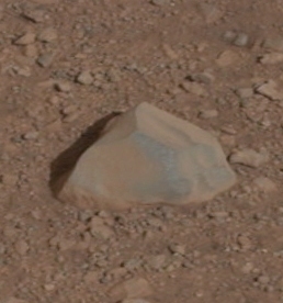
The drive by NASA's Mars rover Curiosity during the mission's 43rd Martian day, or sol, (Sept. 19, 2012) ended with this rock about 8 feet (2.5 meters) in front of the rover. 

The rock is about 10 inches (25 centimeters) tall and 16 inches (40 centimeters) wide. 

The rover team has assessed it as a suitable target for the first use of Curiosity's contact instruments on a rock. 

The image was taken by the left Navigation camera (Navcam) at the end of the drive.

The rock has been named "Jake Matijevic." 

This commemorates Jacob Matijevic (1947-2012), who was the surface operations systems chief engineer for the Mars Science Laboratory Project and the project's Curiosity rover. 

He was also a leading engineer for all of the previous NASA Mars rovers: Sojourner, Spirit and Opportunity. Curiosity's contact instruments are on a turret at the end of the rover's arm. 

They are the Alpha Particle X-Ray Spectrometer for reading a target's elemental composition and the Mars Hand Lens Imager for close-up imaging. 

Image credit: NASA/JPL-Caltech

Read more at: http://phys.org/news/2012-09-mars-rover-curiosity-unusual-enroute.html#jCp

Tuesday, August 21, 2012

NASA's Mars rover Curiosity extended its robotic arm

NASA's Mars rover Curiosity extended its robotic arm on Aug. 20, 2012, for the first time on Mars and used its Navigation Camera (Navcam) to capture this view of the extended arm. 

The view is a mosaic of low-resolution thumbnail images returned to Earth a few hours after the activity on Mars. 

Higher resolution versions were to follow. 

The 7-foot-long (2.1-meter-long) arm maneuvers a turret of tools including a camera, a drill, a spectrometer, a scoop and mechanisms for sieving and portioning samples of powdered rock and soil. 

Numbers around the edge are degrees of the compass and degrees below or above horizontal. 

Curiosity landed on Mars two weeks ago to begin a two-year mission using 10 instruments to assess whether a carefully chosen study area inside Gale Crater has ever offered environmental conditions favorable for microbial life. 

The Space Division of MDA Information Systems Inc. built the robotic arm in Pasadena. 

Image credit: NASA/JPL-Caltech

Monday, August 20, 2012

NASA Mars Rover Curiosity: ChemCam Laser-Zapped it's First Rock Sample

This composite image, with magnified insets, depicts the first laser test by the French designed Chemistry and Camera, or ChemCam, instrument aboard NASA's Curiosity Mars rover. 

The composite incorporates a Navigation Camera image taken prior to the test, with insets taken by the camera in ChemCam.

The circular insert highlights the rock before the laser test. The square inset is further magnified and processed to show the difference between images taken before and after the laser interrogation of the rock.

The test took place on Aug. 19, 2012.

In the composite, the fist-sized rock, called "Coronation," is highlighted.

Coronation is the first rock on any extraterrestrial planet to be investigated with such a laser test.

The widest context view in this composite comes from Curiosity's Navigation Camera. The magnified views in the insets come from ChemCam's camera, the Remote Micro-Imager.

The area shown in the circular inset is 6 centimeters (2.4 inches) in diameter. It was taken before the rock was hit with the laser.

The area covered in the further-magnified square inset is 8 millimeters (about one-third of an inch) across.

It combines information from images taken before and after the test, subtracting the "before" image from the "after" image to make the changes in the rock visible.

ChemCam hit Coronation with 30 pulses of its laser during a 10-second period. Each pulse delivered more than a million watts of power for about five one-billionths of a second.

The energy from the laser excited atoms in the rock into an ionized, glowing plasma. ChemCam also caught the light from that spark with a telescope and analyzed it with three spectrometers for information about what elements are in the target.

This initial use of the laser on Mars served as target practice for characterizing the instrument but may provide additional value.

Researchers will check whether the composition changed as the pulses progressed. If it did change, that could indicate dust or other surface material being penetrated to reveal different composition beneath the surface.

ChemCam was developed, built and tested by the U.S. Department of Energy's Los Alamos National Laboratory in partnership with scientists and engineers funded by France's national space agency, Centre National d'Etudes Spatiales (CNES) and research agency, Centre National de la Recherche Scientifique (CNRS).

Friday, August 10, 2012

NASA Mars Rover Curiosity: NavCam's 3D Images

This picture is the first full-resolution 3D image from the navigational cameras on NASA's Curiosity Mars rover, taken shortly after the robot had lifted up its mast on sol 2 of its 98-week mission (a sol is a Martian solar day, which lasts for 24 hours, 39 minutes, and 35.244 seconds).

The view shows a pebble-strewn surface with the mountainous rim of Gale crater rising in the distance.

To create the eye-popping shot, NASA combined newly received data from the rover's twin navcams, which sit on the remote-sensing mast's WALL-E-like head.

These cameras act like left and right eyes for capturing stereo views of the Martian landscape (see images below).


The navcams can see out to 100 metres and will be used not only to plan the rover's path forward but also for deciding where to aim the MastCam and ChemCam.

MastCam can take colour pictures, video and stitched panoramas, while ChemCam will fire a laser from up to 7 metres away to vaporise rocks and analyse their composition via spectroscopy.

Once the team completes calibrating the cameras, they'll instruct the navcams to take a 360-degree panorama, helping rover drivers get a good hard look at the landing site before driving off toward their main science target, the intriguing mountain inside Gale named Mount Sharp.

Thursday, August 9, 2012

NASA MARS Rover Curiosity NavCams: First 360-Degree Panorama

Remarkable image sets from NASA's Curiosity rover and Mars Reconnaissance Orbiter are continuing to develop the story of Curiosity's landing and first days on Mars.

The images from Curiosity's just-activated navigation cameras, or Navcams, include the rover's first self-portrait, looking down at its deck from above.

Another Navcam image set, in lower-resolution thumbnails, is the first 360-degree view of Curiosity's new home in Gale Crater.

Also downlinked were two, higher-resolution Navcams providing the most detailed depiction to date of the surface adjacent to the rover.

"These Navcam images indicate that our powered descent stage did more than give us a great ride, it gave our science team an amazing freebie," said John Grotzinger, project scientist for the mission from the California Institute of Technology in Pasadena.

"The thrust from the rockets actually dug a one-and-a-half-foot-long [0.5-meter] trench in the surface. It appears we can see Martian bedrock on the bottom. Its depth below the surface is valuable data we can use going forward."

Another image set, courtesy of the Context Camera, or CTX, aboard NASA's Mars Reconnaissance Orbiter (MRO) has pinpointed the final resting spots of the six, 55-pound (25-kilogram) entry ballast masses.

The tungsten masses impacted the Martian surface at a high speed of about 7.5 miles (12 kilometers) from Curiosity's landing location.

NASA Mars Rover Curiosity's New Home: Panoramic Picture

These are the first two full-resolution images of the Martian surface from the Navigation cameras on NASA's Curiosity rover, which are located on the rover's "head" or mast.

The rim of Gale Crater can be seen in the distance beyond the pebbly ground.

The topography of the rim is very mountainous due to erosion.

The ground seen in the middle shows low-relief scarps and plains.

The foreground shows two distinct zones of excavation likely carved out by blasts from the rover's descent stage thrusters.

These are full-resolution images, 1024 by 1024 pixels in size.

Image credit: NASA/JPL-Caltech

Tuesday, August 7, 2012

Guide to NASA MARS Rover Curiosity's Cameras - NavCams

Curiosity also has two pairs of Navigation cameras (Navcams) mounted up high on its mast.

Providing similar image quality as the Hazcams, these cameras will be used to help maneuver the rover to interesting locations.

With a fixed-aperture f/12 focus, the Navcams will capture 45-degree square images.

Teledyne DALSA is proud to contribute to the mission's success.

The image sensors for the Curiosity's Navcams and Hazcams were built in our Bromont, Quebec, semiconductor foundry, as were those on the previous Spirit and Opportunity rovers.

The hazard avoidance cameras are installed on each corner of the rover and the 3D stereoscopic navigation cameras are part of the rover's camera mast.

Guide to NASA MARS Rover Curiosity's Cameras - Haz Cam

Curiosity's hazard avoidance and navigation cameras contain Teledyne DALSA-built CCDs.

The first images from Curiosity came via the machine’s Hazard-Avoidance cameras or Hazcams.

These cameras are responsible for making sure Curiosity doesn’t run into any bad obstacles, and can take black-and-white 1-megapixel images of the area underneath and near the rover.

There are eight Hazcams arranged in pairs on the probe’s front and back, because it can just as easily drive backwards as forwards.

Each camera has a wide-field, fish-eye lens that provides a 124-degree view of the surrounding terrain.

The Hazcams were sheltered behind transparent protective covers immediately after landing, in anticipation of the dust that was kicked up during touchdown, which is why those initial pictures were so splotchy.

Those dust covers will be shot off with a small pyrotechnic device to get clearer images. When the rover gets moving, the front Hazcam pairs will take 3D images of possible targets to help scientists plan the motion of Curiosity’s sample-collecting arm.

Guide to NASA MARS Rover Curiosity's Cameras - MAHLI

For inspecting Martian rocks and soil up close, Curiosity will use its Mars Hand Lens Imager (MAHLI).

Sitting on the end of the rover’s robotic arm, MAHLI’s 2-megapixel color camera can focus on an object as close as three-quarters of an inch away.

It will act as a microscope, resolving material down to 15 microns, roughly half the diameter of a human hair.

MAHLI will be able to work night and day using four white light LEDs and two ultraviolet LEDs.

Images from the camera will be calibrated with a smartphone-sized plaque affixed to the side of the rover that contains colour chips, a stair-step pattern for depth, and a 1909 U.S. penny.

The penny was chosen as a nod to geologists’ tradition of placing a coin for size reference in close-up photographs of rocks.

Guide to NASA MARS Rover Curiosity's Cameras - MastCam

On the ground, the rover’s main workhorse cameras are the impressive MastCams.

Sitting 7 feet above the surface, these 2-megapixel cameras will provide color images and video of the surroundings.

Pictures taken with the MastCams will give you a feeling of what it’s like to stand on Mars, but with superhuman eyesight.

Different filters can be rotated in front of the MastCams, providing images in visible and near-infrared wavelengths.

The two nearly identical MastCams will combine to take 3-D stereo images. They can focus on objects as close as about 7 feet from the rover and see details down to roughly a few hundred microns.

They will see in “true color,” or approximately what your eyes would see if you were there with Curiosity.

Natural lighting on Mars tends to be slightly redder than on Earth because of the high amount of dust in the air.

So the rover will be taking images with a slight adjustment that gives them a warm, orangey glow similar to sunlight at sunset on Earth to capture this effect. The MastCams will also be taking images without this feature.

One of the biggest requests that scientists had for Curiosity was the addition of a telephoto lens.

The previous rovers, Spirit and Opportunity, could see details about as well as a person would on Mars.

But MastCam’s right camera has a 100-mm focal-length lens that provides three times the resolution of previous Mars rover cameras.

It can distinguish between a football and a basketball from seven football fields away.

While the left camera, with its 34-mm lens, can’t see as well, it will provide much wider views – about 15 degrees versus the right camera’s five degree field-of-view.

The MastCams can take full-color 360-degree panoramic images by stitching together 150 individual photos taken in a slowly rotating circle.

Finally, the cameras can also take 720p high-definition video at a rate of about 10 frames per second.