Showing posts with label Mediterranean. Show all posts

Sunday, March 11, 2012

Earth from Space: Algerian sands

This image shows the sandy and rocky terrain of the Sahara desert in western Algeria.

With the Mediterranean Sea almost 500 km away, the closest town to the area pictured here is Taghit in the Algerian province of Béchar.

The commercial Ikonos-2 satellite acquired this image on 23 April 2008 at a spatial resolution of 4 m.

ESA supports Ikonos-2 as a Third Party Mission, which means that the Agency uses its multi-mission European ground infrastructure and expertise to acquire, process and distribute data from the satellite to its wide scientific user community.

Credits: EUSI

Sunday, March 4, 2012

Neanderthals were ancient mariners

Neanderthals may have beaten modern humans to the seas. Growing evidence suggests our extinct cousins criss-crossed the Mediterranean in boats from 100,000 years ago, although not everyone is convinced they weren't just good swimmers.

Neanderthals lived around the Mediterranean from 300,000 years ago. 

Their distinctive "Mousterian" stone tools are found on the Greek mainland and, intriguingly, have also been found on the Greek islands of Lefkada, Kefalonia and Zakynthos

That could be explained in two ways: either the islands weren't islands at the time, or our distant cousins crossed the water somehow.

Now, George Ferentinos of the University of Patras in Greece says we can rule out the former. The islands, he says, have been cut off from the mainland for as long as the tools have been on them.

Ferentinos compiled data that showed sea levels were 120 metres lower 100,000 years ago, because water was locked up in Earth's larger ice caps

But the seabed off Greece today drops down to around 300 metres, meaning that when Neanderthals were in the region, the sea would have been at least 180 metres deep (Journal of Archaeological Science, DOI: 10.1016/j.jas.2012.01.032).

Friday, October 21, 2011

ESA ENVISAT: Aegean islands

This Envisat image is dominated by the island of Crete separating the Aegean and Libyan Seas in the eastern Mediterranean.

At the top of the image we can see the southern portion of the Cyclades island group, including the islands of Milos, Ios, Anafi and Santorini.

This image is a compilation of three passes by Envisat’s radar on 11 December 2010, 10 January and 11 March 2011.

Each is assigned a colour (red, green and blue) and combined to produce this representation.

New colours reveal changes in the surface between Envisat’s passes.

For a high resolution version of this image, please visit: www.esa.int/esaEO/SEMLH2GURTG_index_0.html
Credits: ESA

Monday, August 1, 2011

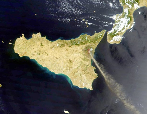
Sicily's cherished volcano, Mt Etna erupts again

Sicily's Mt. Entna volcano seen from the ISS.

Etna ejects a plume of ash that has covered the streets of the city of Catania.

The eruption opened five vents in the mountain and released a cloud of ash that can be seen stretching southeastward over the Mediterranean Sea.

Saturday, October 23, 2010

ESA ENVISAT Image: Straits of Gibralter

ESA's Envisat radar image shows internal waves in the Strait of Gibraltar, between the southern coast of Spain (top) and the northern coast of Morocco.

The strait is the only connection between the Atlantic Ocean (left) and the Mediterranean Sea (right), making it a place of intense study in order to understand the exchange of water between the two.

As water flows into and out of the Mediterranean, two currents are formed in the strait.

An upper layer of Atlantic water flows eastward into the sea over a lower layer of saltier and heavier Mediterranean water flowing westward into the ocean.

The lower current is called the Mediterranean Outflow water. As it leaves the Mediterranean near the strait’s western end, it flows over a sudden rise in the sea floor, generating a series of internal waves.

Internal waves are not directly visible to the observer because they do not result in large undulations on the sea surface; instead, they induce a horizontal surface current, which changes the surface roughness of the sea.

From space, internal waves can be detected very efficiently using Synthetic Aperture Radar (SAR) instruments that are sensitive to changes in the small-scale surface roughness on the ocean surface.

Internal waves in this image show up as a semi-circular rippled pattern east of the strait’s entrance in the Mediterranean Sea. Additional sets of internal waves generated in the Atlantic Ocean are visible as dark pink lines on the western side of the strait.

With hundreds of vessels passing through daily, the strait is one of the busiest shipping routes in the world. The main shipping lanes can be seen through the concentration of ships (colourful points) in distinct channels.

Several cities are visible in Spain (all as patches of light green), including the British oversees territory of Gibraltar (semi-circle at the entrance to the Strait of Gibraltar), Malaga (on the coast about 100 km east of Gibraltar), Granada (northeast of Malaga) and Seville (left of centre top). The Spanish autonomous city of Ceuta is on the coast in North Africa, directly across from Gibraltar.

Tuesday, October 19, 2010

NASA MODIS Images: Dust over Egypt, Libya, and the Mediterranean Sea

Just a few days after dust plumes blew off the coast of Libya, another dust storm spread over Egypt, Libya, and the Mediterranean Sea.

The Moderate Resolution Imaging Spectroradiometer (MODIS) on NASA’s Aqua satellite captured this natural-color image on October 1, 2010.

The dust is thickest over central Libya, where the dust takes on a rippled pattern. Thinner but still discernible dust appears in Egypt.

Over the Mediterranean Sea, dust and clouds form a massive arc that extends eastward toward Cyprus. A fairly thick plume of dust skirts the southwestern edge of that island.

Source points for the dust aren’t obvious in this image. Individual lines of dust in Libya may result from shifting wind patterns at higher latitudes.

What appear to be source points for dust plumes in Egypt are actually features on the land surface partially obscured by a thin veil of dust.

Even though source points are not obvious, the dust likely arose from the massive sand seas that sprawl over Libya and Egypt.

Monday, June 14, 2010

Greenpeace activists sunk by Tuna fishermen

An inflatable craft carrying Greenpeace activists is rammed by what is alleged to be a fishing vessel involved in Blue Fin Tuna fishing in the Mediterranean Sea.
Greenpeace activists were involved in an attempt to free endangered bluefin tuna from a large cage bound for a bluefin tuna farm

Picture: AFP/GETTY