Thursday, March 31, 2011

ESA ENVISAT - GPS measurements from Japan earthquake

GPS measurements of the coseismic displacement of the Japan earthquake on 11 March 2011 by GEONET (reference provided by Prof. Hashimoto).

This displacement chart shows the direction of ground movement. This type of in-situ data can be found on the GeoHazard Supersites web site.

Credits: GEONE

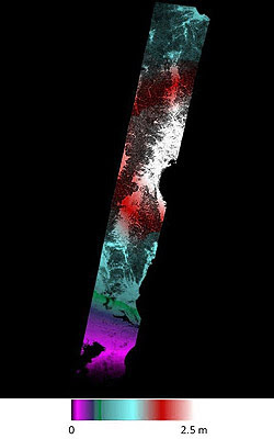
ESA ENVISAT: Terrain Displacement from Japan earthquake from space

A map of the terrain displacement based on Envisat Advanced Synthetic Aperture Radar of the earthquakes that struck Japan beginning on 11 March 2011.

The map is derived from an interferogram generated by INGV using data acquired on 19 February and 21 March 2011 on track 347.

The map shows a large portion of the surface displacement field. The maximum displacement along the Line Of Sight (of the satellite) reaches about 2.5 m relative to a reference point within the entire frame strip located nearby the southern boundary.

Credits: Based on ESA data -The Istituto Nazionale di Geofisica e Vulcanologia (S. Stamondo, M. Chini and C. Bignami)

ESA ENVISAT: Earth movements from Japan earthquake

Envisat Advanced Synthetic Aperture Radar coseismic interferogram from descending track 347, processed by JPL/Caltech ARIA project. Data acquired on 19 February and 21 March 2011, spanning the main shock of the magnitude 9 earthquake and several aftershocks that occurred in Japan on 11 March 2011 and the following days (until 21 March).

One colour cycle represents 50 cm of motion in the satellite line of sight (approximately east at 41 degrees from the vertical), i.e. about 35 cm of motion on the ground. The seismicity plot is from the US Geological Survey.

Credits: Based on ESA data - JPL/Caltech ARIA project (E. Fielding, Principal Scientist JPL/Caltech; S. Yun, Research Scientist JPL/Caltech; P. Agram, KISS Postdoctoral Fellow Caltech)

Inside the Virgin Galactic piggy-back spaceship

SKA: The Square Kilometer Radio Telescope Array

Download and View the SKA Animation Here

Over the past several years, discussions have been occurring in several countries about the next logical step in radio astronomy following the construction of the large millimetre array ALMA. 

An initiative has emerged to develop a telescope to provide two orders of magnitude increase in sensitivity over existing facilities at metre to centimetre wavelengths. 

To achieve this goal will require a telescope with one square kilometre of collecting area - one hundred times more collecting area than the Very Large Array (VLA).


Credit: Canadian glactic plane survey
The Square Kilometre Array (SKA) will probe the gaseous component of the early Universe, thereby addressing fundamental questions in research on the origin and evolution of the Universe. 

The SKA will complement planned facilities at other wavelengths, such as ALMA and James Webb Space Telescope (JWST). HI, CO and continuum radiation would be observed from the interstellar medium of most of the galaxies the JWST will discover in the infrared at large redshifts. 
 
Extensive discussion of the science drivers and of the evolving technical possibilities has led to a concept for the Square Kilometre Array and a set of design goals. 


The SKA will be an interferometric array of individual antenna stations, synthesizing an aperture with diameter of up to several 1000 kilometers. A number of configurations are under consideration to distribute the 1 million square metres of collecting area.
These include 30 stations each with the collecting area equivalent to a 200 metres diameter telescope, and 150 stations each with the collecting area of a 90 m telescope ( more about design and location proposals ).

Approximately 50% of the collecting area is to be contained within a centrally-condensed inner array of 5km diameter to provide ultrahigh brightness sensitivity at arc-second scale resolution for studies of the faint spectral line signatures of structures in the early Universe. 

Another 25 % of the collecting area will be located within a diameter of 150 km, and the remainder out to 3000 km or more. 

This high angular resolution capability will allow imaging of faint emission from the interstellar medium of distant galaxies, as well as the surface of stars, and the active nuclei of galaxies.

Theo Jansen's Strandbeests - Wind Driven Beach Sculpture


Since 1990, Dutch artist Theo Jansen has given life to Strandbeests. They’re made of nothing more than a mass of yellow plastic tubes. But these kinetic sculptures feed off of the wind.

They roam the beaches on their own. And they evolve. Soon enough, Jansen says, you will see Strandbeests living in herds, and who knows what the alchemy of art and engineering will bring next.

This clip comes from a BBC production, Nature Knows Best, that aired late last year. You can also catch Jansen introducing his self-propelling beach animals at TED.

Wednesday, March 30, 2011

QinetiQ providing Robots to Japan recovery operations


In the aftermath of the earthquake and subsequent tsunami that devastated Japan on March 11, 2011, the country faces a massive cleanup and rebuilding effort that will take years.

To assist in the dangerous task of clearing hazardous debris that stretches for hundreds of miles along Japan's east coast, the North American arm of global defense technology company QinetiQ has announced it will provide unmanned vehicle equipment and training to aid in the colossal undertaking.

Robotic Appliqué Kits
The equipment includes QinetiQ's Robotic Appliqué Kits that convert standard Bobcat loaders into unmanned vehicles in just 15 minutes.

This allows all of the Bobcat's 70 vehicle attachments, such as shovels, buckets, grapples, tree cutters and tools to break through walls and doors, to be operated remotely from a safe distance of up to one mile (1.6 km) away.

The kits fit a Bobcat with seven cameras, night vision, thermal imagers, microphones, two-way radio systems and radiation sensors to allow operators to safely remove rubble and debris, dig up buried objects and carry smaller equipment.

If needed, QinetiQ says it is also readying TALON and Dragon Runner robots in Japan.


TALON robot
The TALON robots are small, tracked military robots that are equipped with a chemical, biological, radiological, nuclear and explosive (CBRNE) detection kits that can identify more than 7,500 environmental hazards including toxic industrial chemicals, volatile gases, radiation and explosive risks, as well as temperature and air quality indicators.

The robots, which have used in Iraq and Afghanistan as well as for search and recovery in Ground Zero after September 11, also provide night vision and sound and sensing capabilities from up to 3,280 ft. (1,000 m) away.


Dragon Runner robot
The smaller and more lightweight Dragon Runner robots are designed for use in small spaces and could be used to investigate spaces too small or dangerous for humans to access, such as rubble piles, trenches, culverts and tunnels.

Light enough to be carried in a backpack, the four-wheeled robot is designed to function any way up and its front-mounted tilting thermal cameras and sound sensors can relay data back to its master controller up to 2,625 ft. (800 m) away.

In addition to the unmanned equipment, QinetiQ North America will also provide a team of technical experts to give training and support to Japan's disaster response personnel.

"We are honored to have this opportunity to support Japan's recovery efforts," said QinetiQ North America Technology Solutions Group President JD Crouch. "Our unmanned vehicles will provide reliable, effective, first responder technology to help protect the brave men and women who are working to save lives and restore critical services."