Showing posts with label Japan. Show all posts

Wednesday, December 3, 2014

JAXA Hayabusa 2 probe lifts of for Asteroid 1999 JU3

The rocket carrying Hayabusa 2, Japan's latest asteroid probe, blasts off from the south-western Japanese island of Tanegashima. 

Photograph: Kyodo/Reuters

The JAXA Hayabusa 2 probe aims to touch down on rock called 1999 JU3, blast hole in it and analyse debris for clues to origins of life

A Japanese space probe named Hayabusa 2 blasted off on Wednesday, setting off on a six-year round trip to a land on an asteroid, blow a hole in it and collect samples that scientists hope will help reveal the origins of life.

The launch of the probe, postponed twice because of bad weather, comes less than a month after a European Space Agency probe landed on a comet in a pioneering mission, only to have the lander run out of power due to lack of sunlight on its solar panels.

Hayabusa means peregrine falcon in Japanese.

The probe will map the surface of the asteroid before touching down, deploying small explosives to blast a crater and then collect resulting debris.

Asteroids are believed to have formed at the dawn of the solar system and the probe’s target is one called 1999 JU3, which scientists believe contains organic matter that may have contributed to life on Earth.

The probe is expected to arrive at the asteroid in mid-2018 and return with samples in 2020, the year Tokyo hosts the Olympic Games.

The mission should help Japan’s space programme put a troubled past well behind it.

The first Hayabusa probe was unable to collect as much material as hoped but still made history by being the first vessel to bring back samples from an asteroid.

Its seven-year mission ended in 2010 when it blazed a trail over Australian before slamming into the desert.

Both probes were developed by the Japan Aerospace Exploration Agency.

The first Hayabusa probe was launched on the domestically developed H-2A rocket, as was Hayabusa 2.

In 2003 an H-2A rocket carrying two spy satellites veered off course and had to be destroyed.

The Hayabusa 2 launch was first scheduled for 30 November but delayed twice by bad weather. The last chance for a successful launch before 2016 would have been 7 December.

The European Space Agency’s Philae probe finished a 57-hour mission on the surface of a comet on 15 November, losing battery power due to a poor landing in a spot shielded from the sun it needed to charge the battery for an extended mission.

Saturday, November 1, 2014

Goodbye to TRMM, Japan's first rain radar in space

Artist concept of TRMM in space over the eye of a tropical cyclone. 

Credit: NASA

After 17 years of groundbreaking 3-D images of rain and storms, the joint NASA and JAXA (Japan Aerospace Exploration Agency) Tropical Rainfall Measuring Mission (TRMM) will come to an end next year.

NASA predicts that science operations will cease in or about April 2015, based on the most recent analysis by mission operations at NASA's Goddard Space Flight Center, Greenbelt, Maryland.

On July 8, 2014, pressure readings from the fuel tank indicated that TRMM was near the end of its fuel supply.

As a result, NASA ceased station-keeping maneuvers that would keep the satellite at its operating altitude of 402 km (249.8 miles).

Atmospheric drag is slowing TRMM, and it has begun its slow drift downward. Some fuel has been retained to conduct debris avoidance maneuvers to ensure the satellite remains safe during the drift down to re-entry, which is predicted to occur in the summer of 2015.

Originally launched in 1997 as a three-year mission, TRMM's extended mission life has provided a boon to the scientific understanding of precipitation and its role in broad weather patterns and climate.

TRMM has allowed scientists to better understand how rain varies daily, seasonally and annually; how El NiƱo affects global rain patterns; how regional rain events like the Indian monsoon vary throughout the season; and even how humans have affected local precipitation through the effects of urban heat islands, deforestation and pollution.

"TRMM has been the world's foremost satellite for the study of precipitation and climate processes in the tropics, and an invaluable resource for tropical cyclone research and operations," says TRMM Project Scientist Scott Braun at NASA Goddard.

"Data from TRMM will continue to foster science well after the mission ends, and, when combined with data from the new Global Precipitation Measurement Core Observatory (GPM), launched earlier this year by NASA's partner the Japan Aerospace Exploration Agency (JAXA), will contribute to a long-term precipitation climate record."

This 3-D image of Hurricane Sandy's rainfall was created using TRMM Precipitation Radar data. 

It shows the storm as it appeared on Oct. 28, 2012. 

Credit: NASA /SSAI, Hal Pierce

Orbiting at an angle to the equator that covers 35 degrees north to 35 degrees south of the equator, TRMM carries five instruments that collectively measure the intensity of rainfall, characteristics of the water vapour and clouds, and lightning associated with the rain events.

One of the instruments, the Precipitation Radar, built by JAXA, is the first precipitation radar flown in space.

It returns images of storms that for the first time have revealed close-up, 3-D views of how rain bands in tropical cyclones develop, potentially indicating how strong the storms might become.

Thursday, October 9, 2014

Toshiba Glass on show at CEATAC 2014 Japan

Toshiba plans to introduce its own brand of smart glasses called Toshiba Glass, part of the peeks, prototypes and general buzz events at Ceatec in Japan.

Toshiba Glass is to feature tiny prisms etched into the lenses.

Matt Hill, writing in Gizmodo, referred to the smart glass entry as "the new kid on the block," targeted for release next year.

Tim Stevens of CNET called out the contrasts between Toshiba Glass and Google Glass, saying Toshiba's entry has fewer features, including the lack of camera.

"More significantly, Toshiba Glass must remain physically tethered to a smartphone to work, as it lacks a battery or processing power of its own."

John Anon in AndroidHeadlines also called out differences. "The main difference with Toshiba's Glass is that it does not contain the typical Google prism, the small additional window attached which does provide the user experience."

James Niccolai of the IDG News Service talked about how this works, saying "unlike Google Glass, Toshiba's glasses don't have a prism over the lens to reflect the image into the eye. 

Instead, with Toshiba's product, the glasses lens itself comprises a series of narrow, vertical prisms.

They're pretty much invisible when you look straight through the lens, but an image projected from an angle reflects back into the eye."

Anon commented that "With both the lack of the glasses independence and the limited ability to project information and images Toshiba's offering is unlikely to offer anywhere near the experience provided by Google," he remarked.

At the same time, Anon said Toshiba Glass could find its place in the smart glass market. He said "It is far more likely that Toshiba's version will be more price-relevant to the general public" and, practically speaking, may serve the purpose of use as a tool for instructional purposes.

The Nikkei Asian Review article about Toshiba Glass said it will be promoted "for such everyday applications as reading recipes in the kitchen."

IDG's Niccolai also noted it would be easy to imagine an industrial use case, such as giving an engineer instructions to repair something, so they can still have both hands on the job.

Toshiba hopes to start shipping their glass product next year; the frames are expected to be launched in three styles – standard, sporty and industrial.

Wednesday, October 8, 2014

Toshiba develops lifelike communication android - Video


Following in the footsteps of Hiroshi Ishiguro's eerily lifelike creations, Toshiba Corporation today announced that it has developed a lifelike communication android that can move its arms and hands smoothly and use Japanese sign language.

The android is a prototype that the company will continue to develop towards achieving a service robot able to assist people in the fields of welfare and healthcare.

The android will be showcased at CEATEC JAPAN 2014, which will be held from October 7 to 11.

The android has the appearance of a friendly young woman, an impression accentuated by blinking eyes and a warm smile.

At present, the android can mimic only simple movements, such as exchanging greetings and signing in Japanese, but Toshiba will integrate its wide-ranging technologies in areas including sensing, speech synthesis, speech recognition and robotic control to realize a more sophisticated social robot by 2020.

The goal is to design a companion for the elderly and people with dementia, to offer telecounseling in natural speech, communicate through sign language and allow healthcare workers or family members to keep an eye on elderly people.

Toshiba developed the android in collaboration with aLab Inc., Osaka University, Shibaura Institute of Technology, and Shonan Institute of Technology.

Drawing on technologies and expertise built up through the development of industrial robots, Toshiba created an algorithm to coordinate the movement of 43 actuators in the android's joints.

Shibaura Institute of Technology and Shonan Institute of Technology contributed robot driving and sensor-based motion teaching technologies, and aLab Inc. and Osaka University provided the technologies required to create a body with a human-like resemblance and emulate human expressions.

As a result, the upper part of the body has a human appearance and moves fluidly.

Toshiba aims to put the android into practical use as a receptionist or as an exhibition attendant within next year.

Tuesday, September 30, 2014

NASA TRMM Satellite captures Tropical Storm Phanfone fragments

On Sept. 30, the TRMM satellite passed over Tropical Storm Phanfone and saw fragmented bands of thunderstorms with some isolated areas of heavy rain (red) falling at 2 inches per hour. 

Credit: NASA/SSAI, Hal Pierce

The bands of thunderstorms wrapping around Tropical Storm Phanfone in the Northwestern Pacific Ocean appeared fragmented to NASA's TRMM satellite.

On Sept. 30, a typhoon watch remains in effect for the far northern Marianas Islands including Pagan and, extinct volcano, Alamagan.

Tropical storm warnings have been cancelled for Tinian and Saipan, but remain in effect for PaganAlamagan and surrounding waters.

A flash flood watch remains in effect for the island of Saipan. For updated forecasts for these islands, visit the U.S. National Weather Service Office's Guam website.

On Sept. 30 at 01:51 UTC (Sept. 29 at 9:51 p.m. EDT) from its orbit in space, NASA and the Japan Aerospace Exploration Agency's Tropical Rainfall Measuring Mission (TRMM) satellite passed over Tropical Storm Phanfone.

Most of the rainfall in the fragmented bands of thunderstorms was light to moderate, falling at a rate between 10 and 20 mm (0.39 to 0.79 inch) per hour.

However, TRMM saw some isolated areas of heavy rain falling at 50 mm (2 inches) per hour.

The Joint Typhoon Warning Center noted that animated multi-spectral satellite imagery on Sept. 30 revealed that the tropical storm had slightly unraveled as the bands of thunderstorms had become even more fragmented than they were on Sept. 29.

On Sept. 30 at 1500 UTC (11 a.m. EDT) Phanfone's maximum sustained winds were near 45 knots (83.3 mph/51.7 kph).

It was centered near 17.1 north latitude and 145.0 east longitude, about 103 nautical miles north of Saipan. Phanfone was moving to the west-northwest at 15 knots (17.2 mph/17.7 kph).

Phanfone is forecast to intensify as it moves in a generally northwesterly direction through warm sea surface temperatures, toward the island of Iwo To.

Forecasters at the Joint Typhoon Warning Center expect Phanfone to reach typhoon strength on Oct. 1 and maintain it as it passes west of the island of Iwo To on Oct. 3, later moving toward Japan.

Monday, September 29, 2014

Japan's Mount Ontake eruption: Fumes, smoke and ash hamper rescue efforts - video


Japanese rescue teams have spent a third day searching for survivors on Mount Ontake, trapped by Saturday's eruption.

Recovery efforts have been hampered by conditions as the volcano continues to shoot gas, rocks and ash into the air.

Hundreds of hikers were on the volcano when it erupted. At least 36 people are known to have died.

Rupert Wingfield-Hayes from BBC reports from central Japan.

Saturday, September 27, 2014

Japan's Mount Ontake Volcano eruption 27th Sept 2014 - Video - UPDATE


Mount Ontake erupted late Saturday morning, sending a plume of smoke and ash into the sky, the Japan Meteorological Agency reported.

The bodies of 31 hikers have been found near the top of Japan's Mount Ontake a day after a sudden volcanic eruption.

The hikers were not breathing and their hearts had stopped. The search for a total of 45 for missing climbers has now been called off for the night. 

They have observed 17-20 inches (40-50 centimeters) of volcanic ash covering the ground.

Local authorities had said there were roughly 150 hikers in the area at the time, according to the agency, which raised the Volcanic Alert Level for Ontake from 1 to 3.

Japan is at a triple-plate subduction boundary between the Eurasian continental plate and the Philippine and Pacific oceanic plates.

As the denser oceanic plates dive below the low-density continental plate, water from the saturated sediments lowers the melting point of surrounding rock.

That magma feeds a range of volcanoes mirroring the plate boundary.

Twitter images taken on the volcano were released by hikers.

Left: Hikers evacuating after the eruption. 

Credit: @mori_mori. 

Right: Aerial view of the Mount Ontake eruption. 

Credit: NHK

The volcano is a popular destination for religious pilgrimages, and many hikers were out enjoying the beautiful start to the weekend when the eruption hit.

This photo was posted from near the volcano shortly before the eruption.

The public is advised to not approach the volcano, and police and firefighters have deployed to help hikers near the summit.

About 250 people living near the mountain have decided to remain in their homes, police said.

The volcano last erupted in 2007.

It is located about 155 miles (250 kilometers) west of Tokyo.

A second CNN Video report.

Saturday, September 13, 2014

Japan’s ALOS ("DAICHI") satellite image: Australia's Lake Gairdner

Lake Gairdner in central South Australia is pictured in this image acquired by Japan’s ALOS ("DAICHI") satellite on 1 December 2009.

This image shows mostly the dry, salt-crusted lakebed, while the islands appear brick-red.

Credits: JAXA/ESA

The Lake Gairdner National Park, which includes the nearby lakes Everard and Harris, was established in 1991 for its significant wildlife habitat and natural features.

Japan’s ALOS ("DAICHI") satellite
While the area is hot and dry in summer, spring brings water and is a popular destination for birdwatchers.

Red and western grey kangaroos, emus and feral camels can also be seen here.

When flooded, Gairdner is one of the largest salt lakes in Australia, more than 160 km long and 48 km wide but when dry, the vast salt pan attracts racers attempting to set land speed records and is the site for the annual Speed Week event.

Speed Week 2014 poster.

Credit: Dry Lakes Racers Australia

Monday, August 4, 2014

Japan to launch military space force

The Japan Air Self-Defense Force's F-15J Eagle aircraft perform a flyover during an inspection parade at the Asaka military base in Tokyo on October 24, 2010 

Japan is planning to launch a military space force by 2019 that would initially be tasked with protecting satellites from dangerous debris orbiting the Earth, a report said.

The move is aimed at strengthening Japan-US cooperation in space, and comes after the countries pledged to boost joint work on monitoring space debris, Kyodo news agency said Sunday.

Japan would provide the US military with information obtained by the force as part of the joint bid to strengthen ties in space, the so-called "fourth battlefield", Kyodo said, citing unnamed sources.

Japan's defence ministry is looking at creating the new force using personnel from the Air Self-Defence Force, the country's air force, it added.

The unit would acquire radar and telescope facilities, jointly with the science ministry and the Japan Aerospace Exploration Agency, to run its observatory operations, Kyodo said.

Graphic on space junk and proposals for managing potentially hazardous pieces of defunct space-hardware

Thousands of pieces of debris, including old satellites as well as pieces of rockets and other space equipment, are orbiting the Earth and threaten to collide with functioning communications and reconnaissance satellites.

Sunday, August 3, 2014

ESA GOCE: Lifetime of gravity measurements heralds new beginning

ESA's GOCE mission has delivered the most accurate model of the 'geoid' ever produced, which will be used to further our understanding of how Earth works. 

The colours in the image represent deviations in height (-100 m to +100 m) from an ideal geoid. 

The blue shades represent low values and the reds/yellows represent high values. 

A precise model of Earth's geoid is crucial for deriving accurate measurements of ocean circulation, sea-level change and terrestrial ice dynamics. 

The geoid is also used as a reference surface from which to map the topographical features on the planet. 

In addition, a better understanding of variations in the gravity field will lead to a deeper understanding of Earth's interior, such as the physics and dynamics associated with volcanic activity and earthquakes. 

Image courtesy ESA/HPF/DLR.

Although ESA's GOCE satellite is no more, all of the measurements it gathered during its life skirting the fringes our atmosphere, including the very last as it drifted slowly back to Earth, have been drawn together to offer new opportunities for science.

Carrying the first 3D gravity sensor in space, this state-of-the-art satellite measured Earth's gravity with unprecedented accuracy.

GOCE's four years in orbit resulted in a series of four gravity models, each more accurate than the last.

These models have been used to generate corresponding 'geoids' - the surface of a global ocean moulded by gravity alone.

Shaped by differences in gravity, the geoid is a crucial reference for understanding ocean circulation, sea-level change and ice dynamics.

From a mission that just keeps giving, a fifth model has now been produced. It incorporates data collected throughout the satellite's 42-month operational life.

The previous geoid, released in March 2013, was based on 27 months of measurements.

The satellite was designed to orbit at an extremely low altitude of 255 km to gain the best possible gravity measurements.

At the end of 2012, low fuel consumption allowed operators to extend its life and start to lower the satellite a further 31 km for even more accurate measurements.

This was at the very limit of its capability but maximised the return for science.

After more than doubling its planned life in orbit, the satellite ran out of fuel and drifted back into the atmosphere in November 2013.

The fifth gravity model and geoid, which ESA has recently made available, includes these final precious measurements, right up until the satellite finally stopped working and ironically succumbed to the force it was designed to measure.

Although the satellite is no longer in orbit, scientists now have the best possible information to hand about Earth's gravity, effectively a new beginning for the mission.

GOCE has already shed new light on different aspects of Earth and surpassed its original scope in a number of ways.

It is being used to understand how oceans carry huge quantities of heat around the planet and to develop a global height reference system.

It has provided information about atmospheric density and winds, mapped the boundary between Earth's crust and upper mantle, and used to understand what is going on in these layers far below our feet.

GOCE's achievements also include mapping a scar in Earth's gravity caused by the 2011 Japanese earthquake.

Changes in Earth’s gravity field resulting from the earthquake that hit Japan on 11 March 2011 (mE=10-12s-2). 

A combination of data from ESA’s GOCE mission and the NASA–German Grace satellite, shows the ‘vertical gravity gradient change’. The 'beachball' marks the epicentre.

Credit: ESA

The ultimate geoid model and gravity data will be used for years to come for a deeper understanding of Earth.

ESA's GOCE Mission Manager, Rune Floberghagen, said, "We are very happy with the results of the final, super-low altitude phase of our mission.

"In fact, efforts made by the mission team and by scientists to secure flight operations at these extreme altitudes and to process the data have resulted in a doubling of the information content and a very significant increase in spatial resolution.

"Indeed, our new 'Release 5 solutions' go well beyond the ambitious objectives we had when the GOCE project started.

"Scientists worldwide now have a satellite-based gravity field model at hand that will remain the de facto standard for many years to come."

Sunday, July 27, 2014

ESA Astronaut Alexander Gerst on the ISS

ESA astronaut Alexander Gerst floats through the International Space Station. 

As part of his Blue Dot mission he will perform many scientific experiments in weightlessness that could not be done on Earth.

The International Space Station is a partnership between 15 countries, including Russia, USA, Canada, Japan and ESA member states.

Credits: ESA/NASA

Wednesday, July 9, 2014

Japan plans giant Gundam robot

This file picture taken on July 10, 2009 shows an 18-metre tall statue of the Gundam robot in Tokyo park

A team of Japanese animators and engineers on Wednesday unveiled plans to build a moving 18-metre (60-foot) tall Gundam robot, in a nod to millions of science fiction fans.

The "Mobile Suit Gundam" anime series first aired in Japan in 1979, and spin-offs featuring robots locked in intergalactic battles have won legions of enthusiastic fans in Asia, Europe and elsewhere.

In 2009, the 30th anniversary of the show saw an 18-metre-tall Gundam statue erected in a Tokyo park.

"When I created Gundam 35 years ago, I used my imagination freely because it wasn't real," Yoshiyuki Tomino told reporters in Tokyo Wednesday.

"That is what creativity is for, when you dream of something. Four decades later, Gundam is growing into something new."

Now, the plan is to give a new giant Gundam some moves, and organisers are calling on the public for ideas about how to make it happen.

Plausible suggestions would be used in constructing the robot by 2019, the series' 40th anniversary and a year before Tokyo hosts the Olympic Games.

Wednesday, May 21, 2014

JAXA ALOS-2 "DAICHI-2": Japan satellite to survey disasters, rain forests

Advanced Land Observing Satellite-2 "DAICHI-2" (ALOS-2)
Japan is scheduled to launch a new mapping satellite on Saturday that will be used to survey damage from natural disasters and changes affecting rain forests.

The Advanced Land Observing Satellite-2 "DAICHI-2" (ALOS-2) will be released by the nation's H-IIA rocket, which will lift off shortly after noon (0300 GMT) Saturday, according to the Japan Aerospace Exploration Agency (JAXA).

ALOS-2 will be able to monitor scars left by natural disasters as well as progress made in reconstruction, JAXA said.

The service is important for Japan, which sits on the Pacific Ring of Fire and experiences 20 percent of all major earthquakes felt by humans every year.

"DAICHI-2"
Memories are still fresh of the deadly 9.0-magnitude earthquake in March 2011, which released a killer tsunami that destroyed the northern Pacific coast and triggered the Fukushima nuclear crisis.

The volcanic island nation is routinely hit by earthquakes and typhoons, with scientists expecting Mount Fuji to erupt sometime soon.

The satellite is different from spy satellites that Japan already has to monitor risk states such as North Korea.

The new satellite, nicknamed "DAICHI-2", will "conduct a health check mainly of the Earth's land areas in detail," JAXA project manager Shinichi Suzuki said in a statement.

JAXA H-IIA rocket
DAICHI-2 will collect data related to deformation of the Earth's crust, but also the impact of floods and landslides, he said.

The satellite's predecessor was used to monitor damage caused by the 2011 earthquake and tsunami, Suzuki said.

The device uses a special radar to observe the planet's surface even at night, during bad weather and even through vegetation, JAXA said.

JAXA plans to use the new satellite to regularly study tropical rain forests, which are difficult to observe because of the thick clouds that frequently cover them. It will also be used to observe snow and ice conditions in the polar areas.

Wednesday, March 26, 2014

NASA JAXA GPM: First Images from GPM - Pacific Ocean Cyclone

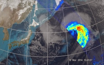
NASA and the Japan Aerospace Exploration Agency (JAXA) have released the first images captured by their newest Earth-observing satellite, the Global Precipitation Measurement (GPM) Core Observatory, which launched into space Feb. 27.

The images show precipitation falling inside a March 10 cyclone over the northwest Pacific Ocean, approximately 1,000 miles east of Japan.


On March 10, the Core Observatory passed over an extra-tropical cyclone about 1,055 miles (1,700 kilometers) due east of Japan's Honshu Island. Satellite data shows the full range of precipitation in the storm.

Image Credit: NASA's Goddard Space Flight Center

Monday, March 10, 2014

JAXA Astronaut Koichi Wakata takes over role as Commander of Space Station - Video

Astronaut Koichi Wakata, pictured at the Baikonur cosmodrome on November 6, 2013, has become the first Japanese commander of the International Space Station Astronaut 

In a simple ceremony onboard the station, Wakata took over the facility's command from Russian predecessor Oleg Kotov, the Japan Aerospace Exploration Agency (JAXA) said late Sunday.


Most previous ISS commanders have hailed from Russia or the United States.

"I am humbled to be assuming command of the station," Wakata said in a video, as he thanked fellow astronauts who were returning to Earth.

"We have had unforgettable memories together."

Wakata, 50, a veteran of several space missions, left for the ISS in November on Russia's Soyuz rocket, and will serve as the commander until May when he is scheduled to return home.

He was joined by what has been billed as the world's first robot astronaut.


Kirobo, a pint-sized android equipped with artificial intelligence, was sent as part of a longer-term project to see how a robot can act as a companion for isolated people, particularly to see if it can develop conversational skills.

Thursday, January 16, 2014

ESA JAXA: Japan scientists test tether to clear up space junk

This artist's impression released September 1, 2011 by the European Space Agency shows the debris field in low-Earth orbit based on current data, not items in their actual size or density

Japanese space scientists are set to trial a tether they hope will help pull junk out of orbit around Earth, clearing up tonnes of planetary clutter, they said Thursday.

Researchers at the Japan Aerospace Exploration Agency (JAXA) have developed what they called an electrodynamic tether made from thin wires of stainless steel and aluminium.

The idea is that one end of the strip will be attached to one of the thousands of dead satellites or bits of rocket that are jamming up space and endangering working equipment.

The electricity generated by the tether as it swings through the Earth's magnetic field is expected to have a slowing effect on the space junk, which should, scientists say, pull it into a lower and lower orbit.

Eventually the detritus will enter the Earth's atmosphere, burning up harmlessly long before it has chance to crash to the planet's surface.

"The experiment is specifically designed to contribute to developing a space debris cleaning method," said Masahiro Nohmi, associate professor at Kagawa University, who is working with JAXA on the project, told reporters.

Nohmi said a satellite developed by the university is expected to be launched into space on February 28, with the tether aboard.

Graphic on debris and defunct space hardware that currently orbit the earth

"We have two main objectives in the trial next month," he said.

"First, to extend a 300-metre (1,000-foot) tether in orbit and secondly to observe the transfer of electricity."

The actual reeling in of orbiting rubbish will be the objective of future experiments, he said.

A spokesman for JAXA said the agency also plans to conduct its own trial on a tether in 2015.

More than 20,000 bits of cast off equipment, including old satellites, pieces of rocket and other fragments are uselessly orbiting the Earth in a band 800-1,400 kilometres (500-900 miles) from the surface of the planet at terrific speed.

Their presence causes problems for space scientists who have to try to prevent them colliding with functioning kit because of the huge damage they can cause.

Monday, December 23, 2013

DARPA Robotics Challenge: Japan's SCHAFT team ahead on points

For those wondering who of 16 competing teams would walk away as top performers in the two-day DARPA Robotics Challenge in Florida over the weekend, the suspense is over.

SCHAFT, a Japanese military robotics company newly acquired by Google, won the most points, 27 out of a possible 32. SCHAFT outscored some formidable big-name contenders such as MIT, Carnegie Mellon, and NASA. IHMC Robotics placed second.

Third place went to Tartan Rescue, from Carnegie Mellon University, and fourth place was awarded to a team from the Massachusetts Institute of Technology.

The fifth-place went to RoboSimian, designed by NASA's Jet Propulsion Laboratory.

All in all, there were eight top scorers. Team TRACLabs, WRECS (Worcester Polytechnic Institute) and Team TROOPER (Lockheed Martin) were the next three.

The eight teams now have the opportunity to continue their work with the help of Defense Advanced Research Projects Agency (DARPA) funding and are to compete in the finals event where one team will net the $2 million prize at the end of 2014.

The Finals will require robots to attempt a circuit of consecutive physical tasks with degraded communications between the robots and their operators.

DARPA said that the 16 teams at this year's challenge in Miami represented a mix of government, academic and commercial backgrounds. They were not only from the United States, but also from South Korea and Japan.

SCHAFT's high scores were impressive as the DARPA Robotics Challenge (DRC), established to advance state of the art in humanoid robot competition, is considered as a baseline on the current state of robotics.

The event is a marker for assessing the evolution of robots in hazardous first-responder environments, a demonstration of what is so far possible in pushing technologies closer to the point where robots will help out in a range of rescue tasks quickly, efficiently and with minimal human interaction.

Friday, December 6, 2013

ESA GOCE: Earth's gravity scarred by earthquake

Changes in Earth's gravity field resulting from the earthquake that hit Japan on 11 March 2011 (mE=10-12s-2). 

A combination of data from ESA's GOCE mission and the NASA-German Grace satellite, shows the 'vertical gravity gradient change'. 

The 'beachball' marks the epicentre.  

Image courtesy DGFI /TU Delft.

ESA's GOCE satellite has revealed that the devastating Japanese earthquake of 2011 left its mark in Earth's gravity - yet another example of this extraordinary mission surpassing its original scope.

GOCE mapped Earth's gravity with unrivalled precision for over four years, but nobody really expected the data to show changes over time.

Now, careful analysis shows the effects of the 9.0 earthquake that struck east of Japan's Honshu Island on 11 March 2011 are clearly visible in GOCE's gravity data.

Large earthquakes not only deform Earth's crust, but can also cause tiny changes in local gravity.

The strength of gravity varies from place to place on our planet's surface and it was GOCE's task to map these variations very precisely.

There are a number of reasons why values of gravity differ, but one is a consequence of material inside Earth being inhomogeneous and unevenly distributed.

Since earthquakes shift around rock and other material tens of km below the surface, they also cause small changes in the local gravity.

Earthquakes under oceans, as in the 2011 Japanese quake, can also change the shape of the sea bed. This displaces water and changes the sea level, which in turn also affects gravity.

After more than doubling its planned life in orbit, the satellite recently ran out of fuel and reentered the atmosphere, largely disintegrating in the process.

Although it is no longer in orbit, the real mission is only just starting because scientists will be analysing the data for years to come to help understand many aspects of our world.

Information from GOCE is being used to understand how oceans transport huge quantities of heat around the planet and to develop a global height reference system, for example.

The mission has already shed new light on different aspects of Earth - from atmospheric density and winds, to mapping the boundary between the crust and upper mantle, and to understand geodynamic processes occurring in these layers far below our feet.

In a surprising discovery earlier this year unrelated to gravity changes, the satellite's accelerometer and ion thruster also revealed that GOCE had 'felt' sound waves in space from the Japanese quake.

NASA Landsat-8: Sakura-jima volcano

Sakura-jima volcano emits a dense plume of ash over the Japanese island of Kyushu. 

Currently Japan's most active volcano, Sakura-jima explodes several hundred times each year. 

These eruptions are usually small, but the larger eruptions can generate ash plumes that rise 3,800 meters (12,000 feet) or more above the 1,040-meter (3,410-foot) summit. 

This true-colour image was collected by the Operational Land Imager on Landsat 8.

Sunday, December 1, 2013

Progress M-21M space freighter docks with ISS via Kurs-NA

An unmanned Russian resupply spacecraft carrying an improved navigation system docked early Saturday with the International Space Station, Russian Mission Control said.

"The manual docking was carried out by cosmonaut Oleg Kotov," Mission Control said.

The Progress M-21M space freighter was loaded with almost 2.5 metric tons of food, fuel, experiment hardware and other supplies for the space station's six Expedition 38 crew members.

The craft lifted off aboard a Soyuz-U launch vehicle from the Russian-leased Baikonur space center in Kazakhstan on Tuesday.

On November 28, the spacecraft conducted flybys of the orbital station and successfully tested a lighter and more efficient automated navigation and docking system, known as Kurs-NA.

The Kurs-NA boasts advanced electronics, a fully-digitized control system and increased docking precision compared to its predecessor, Kurs. The improved system will be used on all upgraded Soyuz and Progress vehicles in the future.

The space station's crew currently comprises Russian cosmonauts Mikhail Tyurin, Sergey Ryazanskiy and Oleg Kotov, NASA astronauts Rick Mastracchio and Mike Hopkins, and Japanese astronaut Koichi Wakata.