Showing posts with label JAXA. Show all posts

Wednesday, December 3, 2014

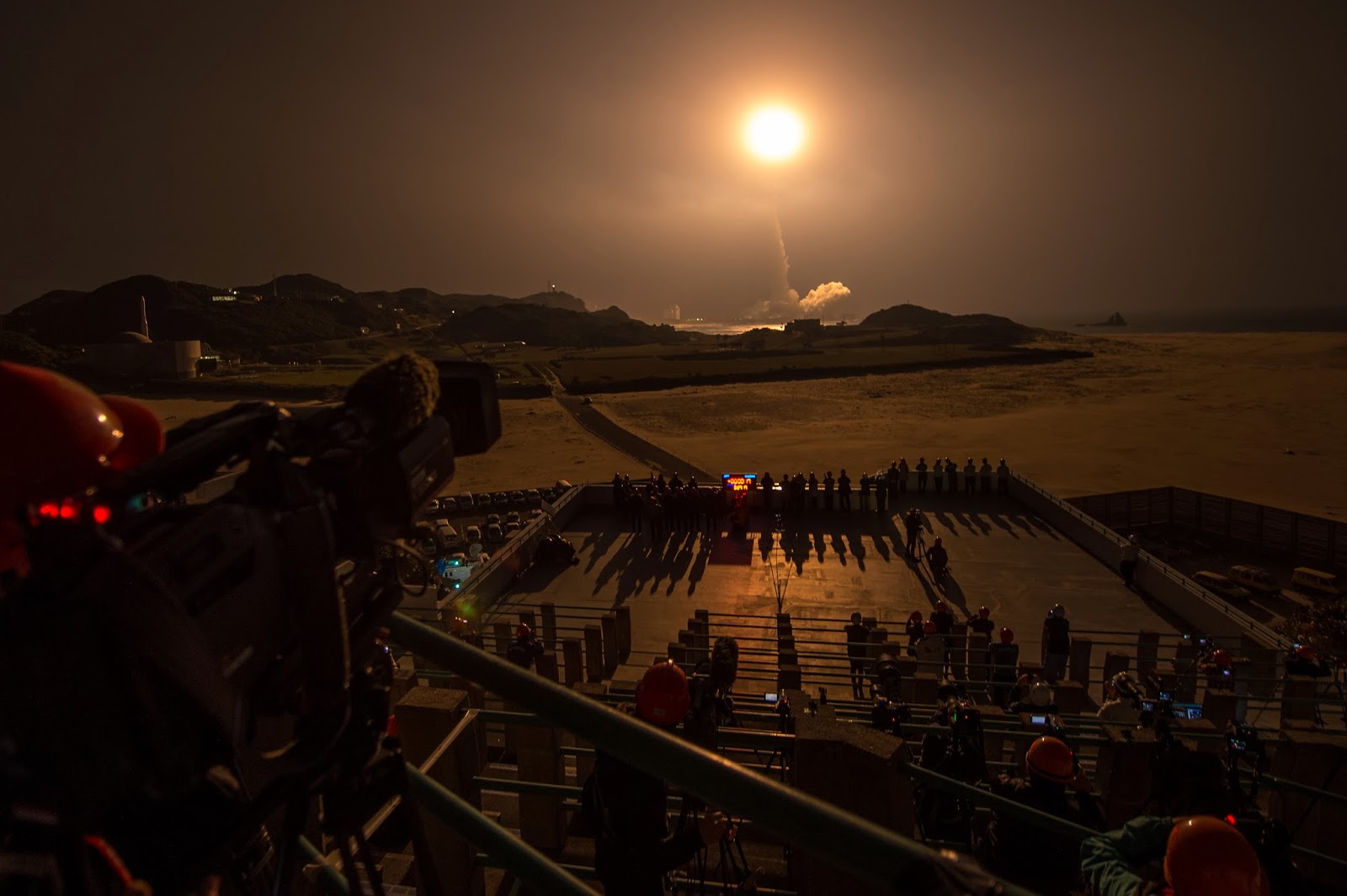
JAXA Hayabusa 2 probe lifts of for Asteroid 1999 JU3

The rocket carrying Hayabusa 2, Japan's latest asteroid probe, blasts off from the south-western Japanese island of Tanegashima. 

Photograph: Kyodo/Reuters

The JAXA Hayabusa 2 probe aims to touch down on rock called 1999 JU3, blast hole in it and analyse debris for clues to origins of life

A Japanese space probe named Hayabusa 2 blasted off on Wednesday, setting off on a six-year round trip to a land on an asteroid, blow a hole in it and collect samples that scientists hope will help reveal the origins of life.

The launch of the probe, postponed twice because of bad weather, comes less than a month after a European Space Agency probe landed on a comet in a pioneering mission, only to have the lander run out of power due to lack of sunlight on its solar panels.

Hayabusa means peregrine falcon in Japanese.

The probe will map the surface of the asteroid before touching down, deploying small explosives to blast a crater and then collect resulting debris.

Asteroids are believed to have formed at the dawn of the solar system and the probe’s target is one called 1999 JU3, which scientists believe contains organic matter that may have contributed to life on Earth.

The probe is expected to arrive at the asteroid in mid-2018 and return with samples in 2020, the year Tokyo hosts the Olympic Games.

The mission should help Japan’s space programme put a troubled past well behind it.

The first Hayabusa probe was unable to collect as much material as hoped but still made history by being the first vessel to bring back samples from an asteroid.

Its seven-year mission ended in 2010 when it blazed a trail over Australian before slamming into the desert.

Both probes were developed by the Japan Aerospace Exploration Agency.

The first Hayabusa probe was launched on the domestically developed H-2A rocket, as was Hayabusa 2.

In 2003 an H-2A rocket carrying two spy satellites veered off course and had to be destroyed.

The Hayabusa 2 launch was first scheduled for 30 November but delayed twice by bad weather. The last chance for a successful launch before 2016 would have been 7 December.

The European Space Agency’s Philae probe finished a 57-hour mission on the surface of a comet on 15 November, losing battery power due to a poor landing in a spot shielded from the sun it needed to charge the battery for an extended mission.

Wednesday, November 26, 2014

JAXA Ready to Face New Challenges - Hayabusa2


It has been four years since the Hayabusa’s dramatic return from space,bringing back the world’s first samples from an asteroid.

To further clarify the mystery of the origin and evolution of human beings, the Hayabusa2 is leaving for space.

This video explains the special features and significance of the Hayabusa2 mission in an easy and simple manner.

Saturday, November 1, 2014

Goodbye to TRMM, Japan's first rain radar in space

Artist concept of TRMM in space over the eye of a tropical cyclone. 

Credit: NASA

After 17 years of groundbreaking 3-D images of rain and storms, the joint NASA and JAXA (Japan Aerospace Exploration Agency) Tropical Rainfall Measuring Mission (TRMM) will come to an end next year.

NASA predicts that science operations will cease in or about April 2015, based on the most recent analysis by mission operations at NASA's Goddard Space Flight Center, Greenbelt, Maryland.

On July 8, 2014, pressure readings from the fuel tank indicated that TRMM was near the end of its fuel supply.

As a result, NASA ceased station-keeping maneuvers that would keep the satellite at its operating altitude of 402 km (249.8 miles).

Atmospheric drag is slowing TRMM, and it has begun its slow drift downward. Some fuel has been retained to conduct debris avoidance maneuvers to ensure the satellite remains safe during the drift down to re-entry, which is predicted to occur in the summer of 2015.

Originally launched in 1997 as a three-year mission, TRMM's extended mission life has provided a boon to the scientific understanding of precipitation and its role in broad weather patterns and climate.

TRMM has allowed scientists to better understand how rain varies daily, seasonally and annually; how El Niño affects global rain patterns; how regional rain events like the Indian monsoon vary throughout the season; and even how humans have affected local precipitation through the effects of urban heat islands, deforestation and pollution.

"TRMM has been the world's foremost satellite for the study of precipitation and climate processes in the tropics, and an invaluable resource for tropical cyclone research and operations," says TRMM Project Scientist Scott Braun at NASA Goddard.

"Data from TRMM will continue to foster science well after the mission ends, and, when combined with data from the new Global Precipitation Measurement Core Observatory (GPM), launched earlier this year by NASA's partner the Japan Aerospace Exploration Agency (JAXA), will contribute to a long-term precipitation climate record."

This 3-D image of Hurricane Sandy's rainfall was created using TRMM Precipitation Radar data. 

It shows the storm as it appeared on Oct. 28, 2012. 

Credit: NASA /SSAI, Hal Pierce

Orbiting at an angle to the equator that covers 35 degrees north to 35 degrees south of the equator, TRMM carries five instruments that collectively measure the intensity of rainfall, characteristics of the water vapour and clouds, and lightning associated with the rain events.

One of the instruments, the Precipitation Radar, built by JAXA, is the first precipitation radar flown in space.

It returns images of storms that for the first time have revealed close-up, 3-D views of how rain bands in tropical cyclones develop, potentially indicating how strong the storms might become.

Monday, September 22, 2014

NASA JAXA TRMM satellite measures Hurricane Odile's heavy rainfall

This TRMM rainfall analysis from Sept. 9-19, 2014 shows heaviest rainfall, up to 33 inches appear in purple in the ocean off southwestern Mexico where Odile and other tropical cyclones formed. 

Rainfall totals above 12.5 inches near Baja California peninsula and over 6.3 in northwestern Texas. 

Credit: NASA/SSAI, Hal Pierce

During the week of Sept. 15, Hurricane Odile and its weakened remnants produced heavy rainfall that caused dangerous flooding over Mexico's Baja California peninsula and southwestern United States.

NASA's Tropical Rainfall Measuring Mission (TRMM) satellite gathers data on rainfall that was used to create a map that showed estimated totals that in one case neared almost three feet!

Some of Odile's may have been welcomed in the U.S. Southwest where some areas have been experiencing extreme to exceptional drought conditions, but some was extreme and led to flooding.

TRMM was launched in November 1997 with the primary mission of measuring rainfall in the Tropics using a combination of passive microwave and active radar sensors.

TRMM is a joint mission between NASA and the Japan Aerospace Exploration Agency (JAXA).

A rainfall analysis was created using real-time TRMM Multi-Satellite Precipitation Analysis (TMPA) data produced at the NASA's Goddard Space Flight Center in Greenbelt, Maryland. Those data are used to monitor rainfall over the global Tropics.

TMPA rainfall totals from September 9 through 19, 2014 were gathered during the period when Hurricane Odile formed over the eastern Pacific Ocean southwest of Mexico, hit Baja California and when the dissipating tropical cyclone was spreading rainfall over the southwestern United States.

The heaviest rainfall during this period was found in the ocean off southwestern Mexico where Odile and other tropical cyclones have recently formed.

In that area, rainfall totals reached up to 840 mm (33 inches) , almost three feet!

Rainfall along Mexico's Baja California Peninsula were over a foot. TRMM data showed rainfall totals above 320 mm (12.5 inches) there.

The TRMM analysis showed that in southwestern United States Odile's remnants produced the highest rainfall totals of over 160 mm (6.3 inches) in northwestern Texas.

Friday, September 19, 2014

ESA Earth Observation Image: JAXA ALOS satellite views Helsinki

This image acquired by Japan’s ALOS satellite on 28 June 2009 shows Finland’s capital and largest city, Helsinki (upper right), on the shores of the Gulf of Finland.

The gulf is the eastern arm of the Baltic sea, stretching all the way to St Petersburg in Russia.

The waters are relatively shallow, with an average depth of about 38 m and maximum depth of about 100 m.

During winter, usually in January, the waters freeze and stay frozen until about April.

Satellites play an important role during this season for shipping, providing imagery that helps icebreaker boats navigate through these frozen waters.

Situated on the tip of a peninsula and on more than 300 islands, Helsinki is sparsely populated compared to other European capitals and has many green areas.

Running north to south through the centre of the city is a 10 km-long forested park that offers opportunities for outdoor sports and activities to Helsinki’s residents.

This year, the park celebrates its 100-year anniversary, marked by various activities including nature walks, a photo competition and other events.

North of the city we can see the runways of the Helsinki airport, while farther west, the large, dark green area of Nuuksio National Park is evident.

The image is featured on the Earth from Space video programme.


Saturday, September 13, 2014

Japan’s ALOS ("DAICHI") satellite image: Australia's Lake Gairdner

Lake Gairdner in central South Australia is pictured in this image acquired by Japan’s ALOS ("DAICHI") satellite on 1 December 2009.

This image shows mostly the dry, salt-crusted lakebed, while the islands appear brick-red.

Credits: JAXA/ESA

The Lake Gairdner National Park, which includes the nearby lakes Everard and Harris, was established in 1991 for its significant wildlife habitat and natural features.

Japan’s ALOS ("DAICHI") satellite
While the area is hot and dry in summer, spring brings water and is a popular destination for birdwatchers.

Red and western grey kangaroos, emus and feral camels can also be seen here.

When flooded, Gairdner is one of the largest salt lakes in Australia, more than 160 km long and 48 km wide but when dry, the vast salt pan attracts racers attempting to set land speed records and is the site for the annual Speed Week event.

Speed Week 2014 poster.

Credit: Dry Lakes Racers Australia

Tuesday, September 2, 2014

Japan space agency unveils Hayabusa-2 (MUSES-C) asteroid hunting probe

Artist's impression of Hayabusa (MUSES-C) in proximity to Itokawa's surface.

Japanese space scientists have unveiled the asteroid hunting space probe they hope to launch later this year on a mission to mine a celestial body.

The probe, named Hayabusa-2, is expected to be flung into space on a rocket for a mammoth four year voyage to the unpoetically-named 1999JU3 asteroid.

When it gets there, some time in 2018, it will release a powerful cannon which will fire a metal bullet at the asteroid's barren crust, once the probe itself has scuttled to safety on the far side of the rock.

It will then return to scoop up material uncovered by the cannon blast.

If all goes well, these pristine asteroid samples will be returned to Earth by the time Tokyo hosts the Olympic Games in 2020.

At a weekend press conference, Hitoshi Kuninaka, project leader at the Japan Aerospace Exploration Agency (JAXA) said he and his team were readying to redouble their efforts for this "new voyage".

"I'm grateful as the new asteroid probe is now nearly complete," he said, according to Jiji Press.

The probe is the successor to JAXA's first asteroid explorer, Hayabusa—the Japanese term for falcon—which returned to earth in 2010 with dust samples after a trouble-plagued seven-year mission.

The spherical 1999JU3 asteroid, which is around a kilometre (half a mile) across, contains significantly more organic matter and water than the potato-shaped rock previously studied by the original Hayabusa.

Analysing this valuable cosmic material could shed light on the mysteries surrounding the solar system and its origins 4.6 billion years ago.

Scientists at JAXA say Hayabusa-2 will build on the work of its predecessor, which was only able to collect surface dust samples that could have been altered by years of exposure to various forms of energy encountered in space.

Despite various setbacks during its epic seven-year journey, including intermittent loss of communication and damage to its motors, the first Hayabasa was hailed as a triumph of science when it returned to Earth.

JAXA's work guiding the craft back to terra firma made it a source of pride for Japan, even inspiring several Japanese feature films.

Kuninaka said there were a number of possible complications and pitfalls that could await Hayabusa-2.

"Of course, I hope things will go smoothly," said Kuninaka.

"We have had many difficulties in the process of developing the new asteroid probe. Space is never an easy place," he said.

Asteroids are believed to retain materials unchanged from the solar system's earliest days, unlike scorched remains such as meteorites or materials on Earth which have been transformed through pressure and heat.

The 1999JU3 asteroid was selected in part because of its make-up and also because of its relative accessibility.

Monday, August 4, 2014

NASA NEEMO 18 Expedition: Astronauts complete underwater mission

Astronaut Jeanette Epps on an undersea exploration traverse EVA during NEEMO 18.

Four astronauts splashed up from the depths of the Atlantic Ocean on July 29, bringing to a successful close the 18th NASA Extreme Environment Mission Operations (NEEMO) expedition.

"Splashup" took place at 11:40 a.m. EDT Tuesday.

Accompanied by two lab technicians, the crew, commander Akihiko Hoshide of the Japan Aerospace Exploration Agency, NASA's Jeanette Epps and Mark Vande Hei, and Thomas Pesquet from the European Space Agency, spent nine days living and conducting research 62 feet below the surface in Florida International University's Aquarius Reef Base undersea research habitat off the coast of Key Largo, Fla.

They investigated tools, techniques and technologies that will benefit space-voyagers aboard future International Space Station (ISS) and long-duration exploration missions.

The mission's scientific investigations focused on a suite of studies from NASA's Human Research Program covering behavioural health and performance, human health and countermeasures, and human factors and habitability.

These studies examined such issues as team cohesion and the ability of crew members to perform tasks while working under constraining factors including isolation, confinement, remoteness, circadian rhythm disruption, communication delays and work overload.

Akihiko Hoshide
"NEEMO is about working and living together," Hoshide said.

"Not just the six aquanauts inside the habitat, but also with the entire team on the surface, the support divers, and the researchers. It is a great spaceflight analog in that aspect, too."

"Teamwork is the key to success, and we worked well. I am grateful to have worked with such professionals, who made my work as the NEEMO 18 commander easy and enjoyable."

NEEMO 18 extravehicular activities evaluated tools and techniques for exploration tasks across gravity fields ranging from asteroids, to the moons of Mars and Mars surface.

Techniques to address re-planning of exploration operations to account for varying time delays in communications were addressed.

Mark Vande Hei
"NEEMO 18 was a fantastic opportunity for me to participate in the development of technologies and techniques for future exploration," said Vande Hei.

"That by itself would have been plenty, but on top of that I got to experience life in an environment that most of us don't get to experience as well as enjoy the company of some fantastic teammates, both on the crew and in the ground control and support team."

NEEMO 18 engineering studies included evaluating the use of Bluetooth technology to monitor each crew member's heart rate.

The successful outcome of this analysis will help address future upgrades to the existing suite of heart rate monitoring equipment aboard the space station.

The mission's scientific and exploration objectives were completed.

The extreme environment of life undersea is as close to being in space as possible, thus making such missions excellent analogs for spaceflight. Parallels between life underwater and in space were drawn throughout the mission.

Thomas Pesquet
"I consider myself extremely lucky to have 'flown' this mission with such professional and talented crewmembers," Pesquet said.

"I learned so much by just watching them go about their busy schedule, solve complex tasks, think out-of-the-box."

"Our commander Aki also made a point of always linking what happened down here to what he experienced up there in space, and the parallels were constantly made, with invaluable knowledge passed on to the rest of the crew."

For the crew members, the experience of living beneath the waves is something they will not soon forget.

In Vande Hei's words, "Personally, I'll never forget the womb-like peace of being out of the habitat, diving, at night, lights off."

"The sparks of luminescence that occurred when I clapped my hands or the puffs of that luminescence that spontaneously occurred made it seem like I was on another planet."

ESA Herve Stevenin at Aquarius base
Future  Mission: NEEMO 19
NASA will return to Aquarius on Sept. 7 for NEEMO 19, a seven-day mission.

NASA astronaut Randy Bresnik will command the second 2014 mission. He will be joined by Canadian Space Agency astronaut Jeremy Hansen, ESA astronaut Andreas Mogensen, and Herve Stevenin, ESA's Head of Extravehicular Activity (EVA) Training at the European Astronaut Center in Cologne, Germany.

NEEMO 19 will focus on the evaluation of tele-mentoring operations for ESA.

Telementoring is when a crew member is given instruction for a task by an expert who is located remotely but is virtually present via a video and voice connection.

Friday, July 4, 2014

Satellite X-ray observations: Neutron star with doughnut-shaped magnetic field and axial wobble

An artist's impression of a magnetar with an intense torroidal magnetic field in its core. 

Credit: NASA /CXC /M.Weiss

When a massive star dies, it can collapse under its own gravity with such force that it produces a supernova, leaving behind an extremely dense remnant consisting almost entirely of neutrons, a neutron star.

Some neutron stars, known as magnetar, possess powerful magnetic fields, which are stronger than any other known magnetism in the Universe.

These intense magnetic fields somehow produce high-energy x-ray pulses, but this process is not well understood.

Kazuo Makishima from RIKEN's MAXI Team and Teruaki Enoto from the RIKEN Nishina Center for Accelerator-Based Science in collaboration with the University of Tokyo and NASA have now found evidence that the magnetar 4U 0142+61 'wobbles' about its rotational axis, implying that the sphericity of the star is distorted due to an intense donut-shaped magnetic field at its core.

"Magnetars emit high-energy 'hard' x-rays, but the origins of these emissions are unknown," explains Makishima.

"We observed 4U 0142+61 using the Suzaku x-ray astronomy satellite (formerly known as Astro-E2) to find out whether the magnetar's emissions change over time."

The magnetar had previously been measured to spin at a rate of one revolution in about 8 seconds and to produce x-ray pulses of the same period, but Makishima and his co-workers noticed slow fluctuations in the arrival times of the x-ray pulses.

They attributed these fluctuations to axial wobble, known as free precession.

The star's axis precesses with a period that differs very slightly from the star's rotation period, and the slow beat between the two periods changes the observed emissions.

"The idea of free precession was not in my mind when we started the data analysis," says Makishima, "but I was familiar with it through my long experience with spinning satellites."

"The precession is most likely caused by a slight deformation of the magnetar, and the deformation is possibly due in turn to internal magnetic fields that are even stronger than the external visible fields."

The findings suggest that the magnetar is deformed from a perfect sphere due to an extremely strong, tightly wound toroidal magnetic field buried deep in the star's core.

The results therefore support the hypothesis that the hard-x-ray pulses are produced by consuming magnetic energy.

Makishima's team plans to analyze a third dataset from 4U 0142+61 and search the Suzaku data for other magnetars that might show similar effects.

"We will also propose observations of these objects with ASTRO-H, the powerful successor to Suzaku, which will be launched in 2015," he says.

More information: Makishima, K., Enoto, T., Hiraga, J. S., Nakano, T., Nakazawa, K., Sakurai, S., Sasano, M. & Murakami, H. Possible evidence for free precession of a strongly magnetized neutron star in the magnetar 4U 0142+61. Physical Review Letters 112, 171102 (2014). DOI: 10.1103/PhysRevLett.112.171102

Thursday, May 29, 2014

Russia to abandon Manned Space Station in 2020

Man in orbit might become history after 2020, as Russia sees no need to keep the ISS operating, announced Vice Prime Minister Dmitry Rogozin. Manned flights make little profit for Russia's space agency, which might focus on other projects.

Russia's Roskosmos space corporation gets little commercial payback from the International Space Station despite spending up to 30 percent of its annual budget on the project, said Rogozin, who is also responsible for the defence industry.

"Our profit is flat low... so we see no business interest in it [going on with the ISS]. Would there be other commercial proposals [we'd consider them]," Rogozin said.

"There are rumors about Russia leaving the ISS project. We will not, the program is set to run until 2020 and we will stick to our international obligations. As for prolonging it till 2024 - that's what we are really doubtful of," Rogozin stressed.

"Simply circling the earth's orbit and earning something on cosmonaut delivery to space - that's not enough for this great space country [Russia]," Rogozin said, adding that Roskosmos needs an innovative space exploration plan that would imply a technological breakthrough from the technologies of the last century.

Roskosmos is due to deliver a preliminary plan by June 15, according to Rogozin.

"As for our manned flights plans beyond 2020 - we would probably have new projects with an expanded number of partners," he said, specifying that a general agreement has been reached with China and that negotiations of further Russia-China space cooperation are due to start in late June. India has also expressed interest in joint space exploration programs, he said.

The Chinese are making great progress in space exploration but it does not mean Moscow and Beijing are necessarily discussing development of a joint space station, Rogozin stressed.

Moscow to close US GPS Stations
Rogozin once again confirmed that Moscow is firmly set to shut down 11 American correctional GPS stations situated in Russia's 10 regions on June 1 if Washington continues to ignore Moscow's requests on deployment of similar stations on US territory.

If there is no reaction from the US by May 31, the GPS stations will suspend operation for the next three months.

If that does not help either, the operation of GPS stations in Russia will cease to exist by August 31, Rogozin promised, adding that this will not interfere with ordinary users of the system in Russia, because the information collected by these stations is being used primarily by the US military and national security agencies.

"These [GPS] stations are situated primarily alongside the Northern Sea Route and it is a big question why they were deployed on our territory in the mid-1990s and for what purpose," the Deputy PM said, stressing that once the stations are gone, "the American military would feel the difference, whereas Russian GPS users would not."

Wednesday, May 21, 2014

JAXA ALOS-2 "DAICHI-2": Japan satellite to survey disasters, rain forests

Advanced Land Observing Satellite-2 "DAICHI-2" (ALOS-2)
Japan is scheduled to launch a new mapping satellite on Saturday that will be used to survey damage from natural disasters and changes affecting rain forests.

The Advanced Land Observing Satellite-2 "DAICHI-2" (ALOS-2) will be released by the nation's H-IIA rocket, which will lift off shortly after noon (0300 GMT) Saturday, according to the Japan Aerospace Exploration Agency (JAXA).

ALOS-2 will be able to monitor scars left by natural disasters as well as progress made in reconstruction, JAXA said.

The service is important for Japan, which sits on the Pacific Ring of Fire and experiences 20 percent of all major earthquakes felt by humans every year.

"DAICHI-2"
Memories are still fresh of the deadly 9.0-magnitude earthquake in March 2011, which released a killer tsunami that destroyed the northern Pacific coast and triggered the Fukushima nuclear crisis.

The volcanic island nation is routinely hit by earthquakes and typhoons, with scientists expecting Mount Fuji to erupt sometime soon.

The satellite is different from spy satellites that Japan already has to monitor risk states such as North Korea.

The new satellite, nicknamed "DAICHI-2", will "conduct a health check mainly of the Earth's land areas in detail," JAXA project manager Shinichi Suzuki said in a statement.

JAXA H-IIA rocket
DAICHI-2 will collect data related to deformation of the Earth's crust, but also the impact of floods and landslides, he said.

The satellite's predecessor was used to monitor damage caused by the 2011 earthquake and tsunami, Suzuki said.

The device uses a special radar to observe the planet's surface even at night, during bad weather and even through vegetation, JAXA said.

JAXA plans to use the new satellite to regularly study tropical rain forests, which are difficult to observe because of the thick clouds that frequently cover them. It will also be used to observe snow and ice conditions in the polar areas.

Sunday, May 4, 2014

ESA Earth Observation: Richat structure in the Sahara desert, Mauritania

Pictured here in this satellite image is the Richat structure, a giant, geological wonder in the Sahara Desert of Mauritania.

Credit: JAXA /ESA

The 40 km-diameter circular Richat structure is one of the geological features that is easier to observe from space than from down on the ground, and has been a familiar landmark to astronauts since the earliest missions.

Once thought to be the result of a meteor impact, researchers now believe it was caused by a large dome of molten rock uplifting and, once at the surface, being shaped by wind and water into what we see today.

Concentric bands of resistant quartzite rocks form ridges, with valleys of less-resistant rock between them.


The dark area on the left is part of the Adrar plateau of sedimentary rock standing some 200 m above the surrounding desert sands.

A large area covered by sand dunes (an erg) can be seen in the lower-right part of the image, and sand is encroaching into the structure’s southern side.

Zooming in on the southern side of the bullseye, we can see individual trees and bushes as tiny dots.

These follow a river-like structure that appears to have been dry when this image was acquired, a few weeks after the rainy season.

Some areas to the south and east of the Richat appear to be covered with temporary lakes, which are dry for most of the year.

Thursday, April 24, 2014

US President Obama talks with Astronauts on Space Station

President Barack Obama and JAXA astronaut Soichi Noguchi hear a message from International Space Station Commander Koichi Wakata, flanked by NASA astronauts Steve Swanson and Rick Mastracchio, while visiting Miraikan, national museum for emerging science and innovation on April 24, 2014 in Tokyo, Japan. 

President Obama is on an Asian tour where he is due to visit Japan, South Korea, Malaysia and Philippines. 

Credit: The Asahi Shimbun

Sunday, April 20, 2014

ISS Crew Grapples with SpaceX Dragon Spacecraft before Docking

The SpaceX Dragon spacecraft successfully berthed at the space station at 9:06 a.m. EDT. 

The mission is the company's third cargo delivery flight to the station.

ISS Commander Koichi Wakata of the Japan Aerospace Exploration Agency, with the assistance of NASA’s Rick Mastracchio, successfully captured the SpaceX Dragon spacecraft with the station’s robotic arm at 7:14 a.m. EDT.

Operations to berth Dragon to the space station begin at approximately 9:30 a.m.

The mission is the company's third cargo delivery flight to the station.

Dragon's cargo will support more than 150 experiments to be conducted by the crews of ISS Expeditions 39 and 40.


The SpaceX-3 Dragon spacecraft separated from the Falcon rocket as it continues on to the International Space Staton.

Liftoff took place at Cape Canaveral Air Force Station's Space Launch Complex 40 at 3:25 p.m. EDT.

Tuesday, March 11, 2014

ISS Astronauts Celebrate 'Cosmos' with Weightless Experiment in Space Station - Video


The new "Cosmos" science TV series on Fox has received an out-of-this-world from astronauts on the International Space Station in a new video showing how weightlessness works.

In the new video beamed from space, NASA astronaut Rick Mastracchio considers Isaac Newton's third law of motion - every action produces an equal and opposite reaction - and demonstrates how this works in microgravity, 260 miles (418 kilometers) above Earth.

To demonstrate this, Rick Mastracchio pushes his colleague and ISS Commander, Japanese astronaut Koichi Wakata, along with a model of NASA's now-retired space shuttle.

As Wakata and the model spacecraft float forward, Mastracchio drifts backwards.

NASA astronaut Rick Mastracchio shows how Newton's third law of motion works in microgravity. 

Credit: YouTube | NASA

"This is simple science but the more complex science we're doing here on the space station will help us bring real world benefits back to humanity on Earth, as well as take us further into the cosmos than ever before, including to an asteroid, the moon or on to Mars," Mastracchio said.

Astrophysicist Neil deGrasse Tyson, host of "Cosmos: A Spacetime Odyssey," introduced the video of his "friends in high places," saying, "when you're doing science, you have to do experiments."

Monday, March 10, 2014

JAXA Astronaut Koichi Wakata takes over role as Commander of Space Station - Video

Astronaut Koichi Wakata, pictured at the Baikonur cosmodrome on November 6, 2013, has become the first Japanese commander of the International Space Station Astronaut 

In a simple ceremony onboard the station, Wakata took over the facility's command from Russian predecessor Oleg Kotov, the Japan Aerospace Exploration Agency (JAXA) said late Sunday.


Most previous ISS commanders have hailed from Russia or the United States.

"I am humbled to be assuming command of the station," Wakata said in a video, as he thanked fellow astronauts who were returning to Earth.

"We have had unforgettable memories together."

Wakata, 50, a veteran of several space missions, left for the ISS in November on Russia's Soyuz rocket, and will serve as the commander until May when he is scheduled to return home.

He was joined by what has been billed as the world's first robot astronaut.


Kirobo, a pint-sized android equipped with artificial intelligence, was sent as part of a longer-term project to see how a robot can act as a companion for isolated people, particularly to see if it can develop conversational skills.

Friday, March 7, 2014

JAXA ALOS Image: Margarita Island, Venezuela

Situated in the southern Caribbean Sea about 20 km off of mainland Venezuela’s coast, Margarita island comprises two peninsulas linked by a long, narrow strip of land – called an isthmus.

The eastern part of the island is home to most of the island’s residents, while the Macanao peninsula to the west is dominated by a central mountain range.

Between the peninsulas and cut off from the open sea by the isthmus lies the La Restinga lagoon, a national park that appears as a dark green and blue area in this image.

Recognised as a wetland of international importance by the Ramsar Convention, the area features picturesque mangroves and is an important feeding ground for birds such as herons and flamingos.

The shallow waters are home to red snappers, sardines and swordfish – among other types of fish – and oysters grow on the mangrove roots.


Japan's DAICHI (ALOS) satellite captured this image on 26 June 2010 with its AVNIR-2 Advanced Visible and Near Infrared Radiometer.

ALOS was supported as a Third Party Mission, which means that ESA used its multi-mission ground systems to acquire, process, distribute and archive data from the satellite to its user community.

In April 2011 the satellite abruptly lost power while mapping Japan’s tsunami-hit coastline.

Thursday, March 6, 2014

NASA JAXA GPM: Earth-based measurements needed to calibrate newest weather satellite

After Atlanta was paralyzed by a rare snowstorm, many fingers were pointed assigning blame for the resulting traffic catastrophe, including at least one aimed at imprecise weather predictions.

"The governor of Georgia said that they thought the heavier snowfall was going to be south of the city," said Ana Barros, professor of civil and environmental engineering at Duke University.

"But there's a lot of uncertainty in those predictions because we don't really understand the fine details of complex storm systems. We don't know how to model these processes at high spatial resolutions."

Ana Barros
This summer, Barros and her colleagues will conduct the first field mission with a new satellite system intended to fill in those knowledge gaps.

On Feb. 27, NASA and Japan's national space agency (JAXA) launched the core satellite for their new Global Precipitation Measurement (GPM) mission from Japan's Tanegashima Space Center.

GPM is an international satellite mission designed to provide more detailed measurements of rain and snow over a wider range of the globe than previously possible.

Not only will the satellite have more precise instrumentation than its predecessors; its orbit will allow researchers to study rainfall at higher latitudes at higher spatial and temporal resolutions.

The data it collects will help unify measurements made by partner satellites and add to science's understanding of how weather works.

Before meteorologists can start plugging the new data in to their weather models, however, researchers have to make sure they can accurately interpret the GPM measurements.

The upcoming field mission, based in the mountains of western North Carolina and led by Duke engineers, will help achieve this by comparing satellite readings with those taken simultaneously from multiple aircraft and ground sensors.

Besides calibrating the new satellite, the campaign will help improve how precipitation processes are represented in forecast calculations.

It will also provide data and inform models used to address critical water management issues in mountainous regions.

"The campaign that we are running will obtain very high-resolution data of precipitation and the microphysics of storm systems in mountainous regions," said Barros.

"The end goal is to improve weather predictions and climate models."

JAXA Hinode SOT Solar Image: Sunspot Activity - Active Region 11967

Active Region 11967 consisted of a major sunspot that released numerous solar flares in early 2014. 

Above is an image taken by the Solar Optical Telescope (SOT) aboard Hinode in the Calcium II H line on Feb. 7, 2014 at 16:09 UT. 

Below is a wider view of Active Region 11967 as seen by SDO on Feb.12, 2014, at 01:35 UT. 

By studying the sun's magnetic field, scientists hope to shed new light on explosive solar activity that can interfere with satellite communications and electric power transmission grids on Earth and threaten astronauts on the way to or working on the surface of the moon. 

Solar Optical Telescope (SOT)
In particular they want to learn if they can identify the magnetic field configurations that lead to these explosive energy releases and use this information to predict when these events may occur. 

The Honide mission is led by the Japan Aerospace Exploration Agency (JAXA), and is a collaboration between the space agencies of Japan, the United States, the United Kingdom and Europe. 

NASA helped in the development, funding and assembly of the spacecraft's three science instruments. 

Hinode is part of the Solar Terrestrial Probes (STP) Program within the Heliophysics Division of NASA's Science Mission Directorate in Washington, which are also responsible for the Solar Dynamcis Observatory (SDO)

Image credit: NASA/JAXA/Lockheed Martin

Saturday, March 1, 2014

NASA-JAXA GPM Launch: Mission to Measure Global Rain, Snow

A Japanese H-IIA rocket with the NASA-Japan Aerospace Exploration Agency (JAXA) Global Precipitation Measurement (GPM) Core Observatory onboard, is seen launching from the Tanegashima Space Center in Tanegashima, Japan. 

Image Credit: NASA/Bill Ingalls

The Global Precipitation Measurement (GPM) Core Observatory, a joint Earth-observing mission between NASA and the Japan Aerospace Exploration Agency (JAXA), thundered into space at 10:37 a.m. PST Thursday, Feb. 27 (3:37 a.m. JST Friday, Feb. 28) from Japan.

The four-ton spacecraft launched aboard a Japanese H-IIA rocket from Tanegashima Space Center on Tanegashima Island in southern Japan.

The GPM spacecraft separated from the rocket 16 minutes after launch, at an altitude of 247 miles (398 kilometers). The solar arrays deployed 10 minutes after spacecraft separation, to power the spacecraft.

"With this launch, we have taken another giant leap in providing the world with an unprecedented picture of our planet's rain and snow," said NASA Administrator Charles Bolden.

"GPM will help us better understand our ever-changing climate, improve forecasts of extreme weather events like floods, and assist decision makers around the world to better manage water resources."

The GPM Core Observatory will take a major step in improving upon the capabilities of the Tropical Rainfall Measurement Mission (TRMM), a joint NASA-JAXA mission launched in 1997 and still in operation.

While TRMM measured precipitation in the tropics, the GPM Core Observatory expands the coverage area from the Arctic Circle to the Antarctic Circle. GPM will also be able to detect light rain and snowfall, a major source of available fresh water in some regions.


To better understand Earth's weather and climate cycles, the GPM Core Observatory will collect information that unifies and improves data from an international constellation of existing and future satellites by mapping global precipitation every three hours.

"It is incredibly exciting to see this spacecraft launch," said GPM Project Manager Art Azarbarzin of NASA's Goddard Space Flight Center in Greenbelt, Md. "This is the moment that the GPM team has been working toward since 2006.

"The GPM Core Observatory is the product of a dedicated team at Goddard, JAXA and others worldwide."

"Soon, as GPM begins to collect precipitation observations, we'll see these instruments at work providing real-time information for the scientists about the intensification of storms, rainfall in remote areas and so much more."