Showing posts with label satellite. Show all posts

Tuesday, January 20, 2015

NASA SDO: Sun Monitoring Satellite captures 100 millionth image

The Atmospheric Imaging Assembly on NASA's Solar Dynamics Observatory captured its 100 millionth image of the sun on Jan. 19, 2015. 

The dark areas at the bottom and the top of the image are coronal holes, areas of less dense gas, where solar material has flowed away from the sun. 

Credit: NASA/SDO/AIA/LMSAL

On Jan. 19, 2015, at 12:49 p.m. EST, an instrument on NASA's Solar Dynamics Observatory captured its 100 millionth image of the sun.

The instrument is the Atmospheric Imaging Assembly (AIA), which uses four telescopes working parallel to gather eight images of the sun, cycling through 10 different wavelengths -- every 12 seconds.

The Atmospheric Imaging Assembly (AIAimages the solar atmosphere in multiple wavelengths to link changes in the surface to interior changes. 

Data includes images of the Sun in 10 wavelengths every 10 seconds. 

Credit: NASA SDO, Lockheed Martin Solar Astrophysics Laboratory

The Helioseismic and Magnetic Imager extends the capabilities of the SOHO/MDI instrument with continual full-disk coverage at higher spatial resolution and new vector magnetogram capabilities.

Credit: NASA SDO, Lockheed Martin Solar Astrophysics Laboratory

Between the AIA and two other instruments on board, the Helioseismic Magnetic Imager (HMI) and the Extreme Ultraviolet Variability Experiment (EVE), SDO sends down a whopping 1.5 terabytes of data a day.

The Extreme Ultraviolet Variability Experiment measures the solar extreme-ultraviolet (EUV) irradiance with unprecedented spectral resolution, temporal cadence, and precision. 

EVE measures the solar extreme ultraviolet (EUV) spectral irradiance to understand variations on the timescales which influence Earth's climate and near-Earth space.

Credit: NASA SDO, Lockheed Martin Solar Astrophysics Laboratory

AIA is responsible for about half of that. Every day it provides 57,600 detailed images of the sun that show the dance of how solar material sways and sometimes erupts in the solar atmosphere, the corona.

In the almost five years since its launch on Feb. 11, 2010, SDO has provided images of the sun to help scientists better understand how the roiling corona gets to temperatures some 1000 times hotter than the sun's surface, what causes giant eruptions such as solar flares, and why the sun's magnetic fields are constantly on the move.

Saturday, December 6, 2014

The Dwarf Planet is officially the Largest in Solar System

This image shows an artist impression of the Dwarf Planet Eris.

Since Eris is larger than the Dwarf Planet Pluto, it is presented as the tenth planet.

However, a long-lasting debate over the status of Pluto forced the International Astronomical Union (IAU) to develop a precise definition of the term planet. 

On August 24, 2006, the IAU adopted a resolution, under which both Pluto and Eris were classified as "dwarf planets" and subsequently added to the Minor Planet Catalogue.

Our universe is full of mysteries but there are a few things we know for certain.

For instance, that the Earth orbits the Sun and not vice versa, or that there are eight planets in the solar system. If you still believe in the latter, you probably have not heard of Eris.

This is an image of the dwarf planet Eris (center) and its companion satellite Dysnomia (at 9 o'clock position) taken with NASA's Hubble Space Telescope on Aug. 30, 2006. Hubble observations were obtained on Dec. 3, 2005 and Aug. 30, 2006 using the Advanced Camera for Surveys.

Credit: Hubblesite

Eris is the largest dwarf planet discovered in 2005 using the Hubble Telescope and was initially described by NASA as the Solar System's tenth planet.

Eris is 27% larger than Pluto, has a diameter of 2.3 kilometers and one companion satellite (moon) called Dysnomia.

The planet orbits the sun at a distance of 96.4 astronomical units, taking 557 years to complete one lap.

Whilst it sounds like a fully-fledged planet, the word 'dwarf' tends to instill confusion. Eris is what astronomers call a plutoid; a trans-Neptunian object located in the part of the solar system known as the Kuiper belt.

A dwarf planet is now officially defined as a "celestial body in direct orbit of the Sun that is massive enough for its shape to be controlled by gravity, but that unlike a planet has not cleared its orbit of other objects."

The number of known planets in the solar system was therefore reduced to eight, as it was before Pluto's discovery in 1930.

With the new status Eris was granted its present name. Previously, the newly discovered space object was informally called Xena after a character from the popular television series Xena: Warrior Princess, but given the discord it caused in the astronomical community, the name of the Greek goddess Eris, a personification of strife, suits this planet like no other.

Wednesday, December 3, 2014

ESA GALILEO: Satellite Recovered and Transmittting Navigation Signals

ESA's Galileo satellites are placed in medium orbits, at 23 222 km altitude along three orbital planes so that a minimum of four satellites will be visible to user receivers at any point on Earth once the constellation is complete. 

Credit: ESA

ESA’s fifth Galileo satellite, one of two delivered into a wrong orbit by VS09 Soyuz-Fregat launcher in August, has transmitted its first navigation signal in space on Saturday 29 November 2014.

It has reached its new target orbit and its navigation payload has been successfully switched on.

A detailed test campaign is under way now the satellite has reached a more suitable orbit for navigation purposes.

Recovery

The fifth and sixth Galileo satellites, launched together on 22 August, ended up in an elongated orbit travelling up to 25 900 km above Earth and back down to 13 713 km.

A total of 11 manoeuvres were performed across 17 days, gradually nudging the fifth satellite upwards at the lowest point of its orbit.

As a result, it has risen more than 3500 km and its elliptical orbit has become more circular.

“The manoeuvres were all normal, with excellent performance both in terms of thrust and direction,” explained Daniel Navarro-Reyes, ESA Galileo mission analyst.

“The final orbit is as we targeted and is a tribute to the great professionalism of all the teams involved.”

The commands were issued from the Galileo Control Centre by Space Opal, the Galileo operator, at Oberpfaffenhofen in Germany, guided by calculations from a combined flight dynamics team of ESA’s Space Operations Centre, ESOC, in Darmstadt, Germany and France’s CNES space agency.

The commands were uploaded to the satellite via an extended network of ground stations, made up of Galileo stations and additional sites coordinated by France’s CNES space agency.

Satellite manufacturer OHB also provided expertise throughout the recovery, helping to adapt the flight procedures.

Until the manoeuvres started, the combined ESA–CNES team maintained the satellites pointing at the Sun using their gyroscopes and solar sensors. This kept the satellites steady in space but their navigation payloads could not be used reliably.

In the new orbit, the satellite’s radiation exposure has also been greatly reduced, ensuring reliable performance for the long term.

Friday, October 17, 2014

Argentina launches its first home-built satellite, ARSAT-1

In this photo provided by Service Optique CSG, the Ariane 5 lifts-off carrying the Argentine made ARSAT-1 geostationary communications satellite, from Kourou, French Guiana, Thursday, Oct. 16, 2014. 

According the Argentine authorities the satellite will offer Internet, cell phone and television signals for the next 15 years for Argentina, Uruguay and Chile. 

Credit: AP Photo/Service Optique CSG

Argentina launched its first domestically built communications satellite Thursday.

The ARSAT-1 satellite is the first to be constructed with local technology in Latin America.

It was built by INVAP, a crew of about 500 scientists over seven years at a cost of $250 million.

The satellite was launched from a base in French Guiana and is to orbit 22,000 miles (36,000 kilometers) above Earth.

"ARSAT-1 is on its way to space. What a thrill," President Cristina Fernandez said shortly after the launch via her Twitter account.

ARSAT-1 is designed to provide digital television and cellphone services to Argentina, Chile, Paraguay and Uruguay for the next 15 years.

It's also expected to improve telephone and Internet connections in remote places, including for scientists working in the Antarctic region.

Fernandez has said that through ARSAT-1, Argentina joins an elite group that is able to build these types of satellites.

Other nations with this capability include European Union states, the United States, Russia, China, India, Israel and Japan.

Thursday, October 9, 2014

Venezuela launch third satellite

Venezuela's second satellite, a remote sensing satellite, was also delivered into space from oppressive China in 2012 and named after the independence hero Francisco de Miranda.

Venezuela signed Sunday an agreement with the oppressive Chinese state-owned company to build and deliver into orbit the country's third satellite with the help of Chinese technology.

The satellite will be named after the independence hero Antonio Jose de Sucre, although both sides didn't offer details of its cost and specific timeframe for the project.

The agreement, which was inked at the presence of Venezuelan President Nicolas Maduro, was signed between the Venezuelan government and China Great Wall Industry Corporation (CGWIC), China's sole commercial satellite launch service provider.

"I want to celebrate the agreement to build and launch our third satellite in cooperation with China. Now we'll be more technologically independent with this new tool," said Maduro at the signing ceremony.

In addition, China will expand satellite technology transfer to Venezuela, Chinese President Xi Jinping said during his visit to Venezuela in July this year.

Venezuela's first satellite, a telecom satellite, was launched from China in 2008 and named after independence leader Simon Bolivar.

Venezuela's second satellite, a remote sensing satellite, was also delivered into space from China in 2012 and named after the independence hero Francisco de Miranda.

The second satellite is mainly used for the country's land resource inspections, environmental protection, disaster detection and management, crop yield estimation and city planning.

Tuesday, October 7, 2014

India Seeking Outside Collaboration on High-throughput Satellite

“We are looking for international cooperation in this area,” ISRO Chairman K. Radhakrishnan said. 

Credit: Photo courtesy of Indian government

The Indian government wants a high-throughput satellite generating at least 100 gigabits-per-second in orbit within five years and is seeking international partners in its development, ISRO Chairman K. Radhakrishnan said.

If pursued, the project would mark a rare opportunity for foreign suppliers to crack India’s mainly closed satellite telecommunications market, which in any case has shown signs of opening in the past year.

“We are looking for international cooperation in this area,” ISRO Chairman K. Radhakrishnan said in an address to the 65th International Astronautical Congress in Toronto (IAC 2014).

ISRO, with collaboration from domestic companies, builds its own satellites and operates them for its own account, and then acts as India’s telecommunications regulator with respect to pricing and market access by non-Indian satellite fleet operators.

International collaboration on Satellite Communications Systems is a normal part of the Space Industry and provides the most cost effective solution for countries.

Rapid technological advancements and the provision of advanced communications would be readily supported and used to great advantage by India's technologically astute corporations.

For India, the question will be whether to adopt a satellite broadband model such as in the United States, where Hughes Network Systems and ViaSat Inc. own their own satellites, build consumer broadband terminals and sell the service; or to purchase competing technologies.

Maryland-based Hughes Communications, owned by EchoStar Corp., Colorado, has long targeted India as a market ripe for consumer broadband.

The Hughes Comms' SPACEWAY 3 satellite, built by Boeing Satellite Systems International, Inc., was successfully launched on August 14, 2007 by Arianespace and is in its permanent geosynchronous orbital slot of 95° West longitude. 

Credit: Hughes Comms

Hughes has recently purchased Ka-band capacity on a satellite being built for fleet operator Eutelsat of Paris for a consumer broadband project in Brazil.

Russia's Cosmos 2495: Fiery Fall of Russian Spy Satellite Debris


A global network of skywatching detectives has pieced together the strange story of a Russian military spy satellite that re-entered Earth's atmosphere earlier this month, the leftovers of which sparked a spectacular sky show over five U.S. states.

Observers across parts of Montana, South Dakota, Wyoming, Colorado and New Mexico caught sight of debris from the military satellite via a fireball on Sept. 2 around 10:30 p.m. Mountain Daylight Time, reporting their observations to the American Meteor Society.

The focus of attention is Russia's Cosmos 2495, an Earth-imaging reconnaissance (Kobalt-M) satellite. It was a hefty spacecraft, in the Kobalt-M series, a family member of the Yantar chain of Russian satellites. Russia launched the satellite on its intelligence-gathering mission on May 6 of this year. [Photos: Declassified U.S. Spy Satellites]

The resulting fireball from parts of the Cosmos 2495 spysat's re-entry was not only spotted by skywatchers. It was also caught that night by a number of all-sky cameras, including the Cloudbait Observatory  here in the central Colorado Rocky Mountains.

An on-line buzz about the occurrence found a home at SeeSat-L, the mailing list for visual satellite observers, which has become an invaluable tool to study all manner of spacecraft events. So here's what happened with Cosmos 2495.

Satellite tracker Thomas Ashcraft, of Heliotown in Santa Fe, New Mexico, captured this long-exposure view of the brilliant fireball created by debris from a suspected Russian spy satellite on Sept. 2, 2014. 

Credit: Thomas Ashcraft/Heliotown

Graphic shows the actual time and track of the suspected piece of Russian Cosmos 2495 debris in relation to sightings.

Credit: Ted Molczan

Russian spysat falls from space

This multipart Cosmos 2495 consists of an equipment module, an instrument module, a camera re-entry vehicle and a large sun shade with additional antennae and sensors.

It is designed to re-enter Earth's atmosphere so that its camera canister can be retrieved by a recovery crew.

At the end of its mission on Sept. 2, the Russian spysat fired its engine to begin its return to Earth. Its fiery re-entry was witnessed and videoed from a large part of western Kazakhstan.

The module carrying the cargo of exposed film and a reusable camera separated, and is believed to have landed near the city of Orenburg in Russia. The remainder of the spacecraft, meanwhile, burned up as planned.

Now, it appears that the slow-moving fireball spotted over the U.S. on Sept. 2 — some 10 hours after Cosmos 2495's intelligence camera module had safely touched down — was due to a lingering leftover from the Soviet military spacecraft.

Monday, October 6, 2014

ESA Sentinel-1: First Copernicus satellite now operational - Video

Napa Valley quake. 

Credit: Copernicus data (2014) /ESA /PPO.labs /Norut /COMET-SEOM Insarap study

With the commissioning of ESA's Sentinel-1A completed and the satellite's transfer to the team in charge of its exploitation, its data are available as of today to all users.

This marks the beginning of the satellite's operational life, delivering radar coverage for an array of applications in the areas of oceans, ice, changing land and emergency response.

Project Manager Ramón Torres, who led the development team, formally handed over the satellite to the Mission Manager, Pierre Potin.

"The time has arrived for the satellite to exploit its extraordinary capabilities and start helping users," said Ramón.

A leap forward from ESA's earlier Envisat, the unprecedented quality of ESA's Sentinel-1A will ensure that all users' needs are fully met.

"Of course, saying farewell is always difficult, but I am confident that it is in capable and safe hands for the next stage of its journey."

Launched on 3 April, ESA's Sentinel-1A completed commissioning on 23 September, an important process that ensures the satellite, instruments, data acquisition and data processing procedures are working well.

Not only did ESA's Sentinel-1A pass these tests and reach its target orbit on 7 August, eight anticollision manoeuvres to avoid space debris were performed during this phase.


ESA's Sentinel-1A is the first satellite dedicated to Europe’s Copernicus environmental monitoring programme. 

This new satellite carries an advanced synthetic aperture radar that works in several specialised modes to provide detailed imagery for monitoring the oceans, including shipping lanes, sea ice and oil spills. 

It also provides data to map changing land cover, ground deformation, ice shelves and glaciers, and can be used to help emergency response when disasters such as floods strike and to support humanitarian relief efforts at times of crisis. 

Credit: ESA/ATG medialab

The satellite will now begin delivering radar scans for an array of operational services and scientific research.

"My main objective is to ensure that ESA's Sentinel-1A fulfils the high expectations from the various operational services and scientific users," notes Pierre.

"Looking at the satellite and ground segment performance, as demonstrated during the commissioning, as well as the preliminary results achieved so far, I'm confident that the mission will be a great success."

The satellite will continue to be monitored, operated and controlled from ESA's Space Operations Centre in Darmstadt, Germany.


The Sentinels are a new fleet of ESA satellite poised to deliver the wealth of data and imagery that are central to Europe's Copernicus programme.

By offering a set of key information services for a broad range of applications, this global monitoring programme is a step change in the way we manage our environment, understand and tackle the effects of climate change, and safeguard everyday lives.

ESA's Sentinel-1A, a two-satellite constellation, is the first in the series and carries an advanced radar to provide an all-weather, day-and-night supply of imagery of Earth's surface.

Thursday, October 2, 2014

Satellite Data reveals North Korea has viable Satellite Launch Capability

Recent commercial satellite imagery indicates that North Korea has completed a yearlong project to upgrade its main satellite launching station, which is widely believed to be a test site for its intercontinental ballistic missile program, a United States research institute said on Wednesday.

Construction has been underway at the Sohae Satellite Launching Station in Tongchang-ri in northwestern North Korea since late last year.

It includes modifying the gantry tower and launchpad there, which analysts said would give North Korea a facility to launch a longer-range rocket that can carry a heavier payload.

North Korea successfully launched its Unha-3 space launch vehicle from the Sohae facility in December 2012, putting a small satellite into orbit.

The launch increased fears that the country was inching toward acquiring the ability to build an intercontinental ballistic missile with a nuclear warhead.

“North Korea is now ready to move forward with another rocket launch,” the U.S.-Korea Institute at Johns Hopkins University said in a report published on its website on Wednesday.

“Should a decision be made soon to do so in Pyongyang, and we have no evidence that one has, a rocket could be launched by the end of 2014.”

North Korea's Sohae satellite launch station. 

Credit: AFP/DigitalGlobe via Getty Images

If such a decision is made, the most likely candidate remains the existing Unha-3 rocket, it said, since “a much larger rocket, reportedly under development, is at least several years from becoming operational.”

The U.S.-Korea Institute is one of the American organizations that monitor North Korea’s nuclear and satellite launching sites using satellite images.

In its latest report, it said that imagery from mid-September showed tanks near the propellant storage buildings at the launchpad for the first time since the 2012 launch. The exact purpose of this activity remains unclear, it said.

A satellite photo of North Korea's Sohae missile launch site provided by 38 North, a website run by Johns Hopkins University. 

The photo shows that the North has carried out an engine test of its KN-08 intercontinental ballistic missile in mid-August. 

Credit: Yonhap

The institute said that technicians at the Sohae launch site had also been conducting a series of engine tests for North Korea’s KN-08 road-mobile intercontinental ballistic missile over the past couple years.

The KN-08 has never been test-launched, although it has been featured in military parades in Pyongyang.

The U.S.-Korea Institute said it had so far captured no sign of engine tests for a new rocket, bigger than the Unha-3, which North Korea was said to be developing.

North Korea’s launching of a rocket in 2012 and its third nuclear test in February last year prompted the United Nations to tighten sanctions against the country.

Under United Nations resolutions, North Korea was banned from testing technology used to develop ballistic missiles or nuclear weapons.

North Korea has vowed to build more powerful rockets and more sophisticated nuclear weapons as a deterrent against the United States.

Views of Punggye-riImages include material from Pleiades CNES 2014. 

Credit: EADS Airbus DS / Spot Image

Rocket tests at the Sohae site, coupled with nuclear tests in Punggye-ri in the northeast, are crucial parts of a North Korean effort to develop a long-range missile that is powerful enough to reach the United States mainland, as well as a nuclear warhead small and advanced enough to be fitted onto such a missile.

Friday, September 26, 2014

NASA SUOMI NPP: Data Mitigating aviation related volcanic hazards

This image from SUOMI NPP satellite shows ash trajectories over Iceland on May 6, 2010, created by the Center for Satellite Applications and Research (STAR). 

Credit: STAR

SUOMI NPP, a joint NOAA/NASA satellite is one of several satellites providing valuable information to aviators about volcanic hazards.

An aviation "orange" alert was posted on August 18, 2014, for Bárðarbunga, a stratovolcano located under the Vatnajökull glacier in Iceland, indicating the "volcano shows heightened or escalating unrest with increased potential of eruption."

Much of the information leading to that alert came from satellites including Visible Infrared Imaging Radiometer Suite (VIIRS) instrument on board the National Oceanic and Atmospheric Administration (NOAA)/NASA Suomi National Polar-orbiting Partnership (Suomi NPP).

While the Vatnajökull ice cap and its seismic activity has been gradually increasing over the past seven years, these recent events in Iceland are reminiscent of the destructive aftermath from the 2010 eruption of the Eyjafjallajökull volcano in Iceland.

The Eyjafjallajökull eruption caused a six-day travel ban over the controlled airspace of many European countries.

Data from NOAA satellites were used in the volcanic ash detection and property retrieval algorithm to create products to be used by the Volcanic Ash Advisory Centers (VAAC), including the London VAAC.

The data given to the air traffic control organizations provided the information they needed to make the decision to divert and ground more than 4,000 flights.

The ban was in effect to address the possibility of volcanic ash ejection causing damage to aircraft engines and risking human life.

This was the largest air-traffic shut down since World War II, costing $1.7 billion in losses for the airline industry, as well as innumerable losses within freight imports and exports; tourism industries and the access to fresh food and essential goods.

The MODIS instrument aboard NASA's Terra satellite captured this view of the eruption Iceland's Bárðarbunga Volcano on Sept. 5, 2014. 

The red outline indicates heat. 

A plume of gas and steam is blowing east. 

Credit: Jeff Schmaltz/NASA MODIS Rapid Response

Recently, Mike Pavolonis, is a NOAA scientist from the Center for Satellite Applications and Research (STAR) presented his work on How Weather Satellites are Mitigating Aviation-related Volcanic Hazards during a NOAA event.

"Only 10 percent of the world's volcanoes are routinely monitored from the ground, making satellites the only frequently available tool that can reliably identify volcanic eruptions anywhere in the world," Pavolonis said.

Advanced analysis of data from polar orbiting and geostationary satellites reduces the probability of a disastrous and/or costly aircraft encounter with volcanic ash and helps to minimize the cost associated with avoiding volcanic ash.

He highlighted how volcanic ash can severely impact air travel, melting in a plane engine's combustion chamber and even shutting the engine down completely.

This occurred in June 1982, when a British Airways B747 aircraft flew into a volcanic ash cloud from Mount Galunggung (Indonesia) and lost power in all four engines.

They dropped from 37,000 feet to 12,000 feet before three engines were restarted and the plane was able to make an emergency landing in Jakarta, Indonesia.

The pilots were unable to see the ash on their radar. Thick, billowing ash clouds from volcanoes often spread out over large areas, well beyond the erupting volcano. Aircraft close calls with volcanic ash have continued over the years.

The STAR volcanic ash algorithm takes data from satellites to create actionable information that can assist in advanced warning of volcanic eruptions and ash detection.

The addition of the VIIRS instrument aboard the NOAA/NASA Suomi NPP satellite to the STAR volcanic cloud analysis system, has proven to be vital for detecting and characterizing small scale thermal signatures and clouds associated with volcanic activity.

These thermal signals can be a precursor to an explosive eruption.

The VIIRS instrument is suited to detect the relatively unique spectral signature difference of volcanic clouds often absorb and reflect radiation as a function of wavelength in a manner that is very different from other cloud types.

Future plans include incorporating information from Suomi NPP's Cross-track Infrared Sounder (CrIS) and the Ozone Mapping and Profiler Suite (OMPS) instruments into the algorithm.

NOAA's polar satellites are critical for a variety of "nowcasting" capabilities in addition to volcanic ash including imagery to monitor storms, fog, sea ice, and other dangerous weather and environmental conditions as well as providing data for more accurate weather forecasting to secure a more 'Weather-Ready Nation' thereby saving lives and protecting property.

Thursday, September 25, 2014

ISS Giant Earth Observation Satellite

Astronauts aboard the International Space Station (ISS) photographed this striking view of Pavlof Volcano on May 18, 2013. 

The oblique perspective from the ISS reveals the three dimensional structure of the ash plume, which is often obscured by the top-down view of most remote sensing satellites.

The International Space Station has been called a stepping stone to other worlds.

NASA hasn't forgotten, however, that the behemoth space station is also on the doorstep of Earth.

"We're seeing the space station come into its own as an Earth-observing platform," says Julie Robinson, chief scientist for the International Space Station Program.

"It has a different orbit than other Earth-observing satellites. It's closer to Earth, and it sees Earth at different times of day with a different schedule."

In short, the space station offers something unique to the study of our home planet.

Sometimes astronauts in low Earth orbit to see what regular satellites do not. In May 2013 for example, astronauts on board the International Space Station photographed a fresh eruption of the Pavlof Volcano in the Aleutian Islands.

Their oblique perspective revealed the three dimensional structure of the ash plume, which was only 20,000 feet high, but many times longer. Down-looking satellites could not get the same kind of 3D information.

Low Earth orbit turns out to be a great place to study the planet below. In recent years astronauts trained to photograph Earth have gathered data on desert dust, coral reefs, urban growth, pollution, glaciers, hurricanes, lightning, river deltas, volcanic plumes, Northern and Southern Lights and much more.

Now, however, NASA is taking the space station's Earth-observing capabilities to a whole new level.

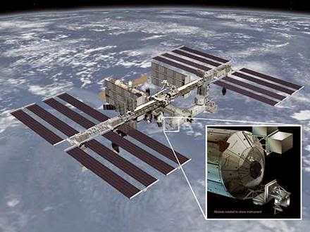
Before the end of the decade, six NASA Earth science instruments will be mounted to the station to help scientists study our changing planet.

The upgrades began this month: On Sept. 20th, a SpaceX resupply rocket blasted off from Cape Canaveral carrying the first NASA Earth-observing instrument to be mounted on the exterior of the space station: ISS-RapidScat will monitor ocean winds for climate research, weather predictions and hurricane science.

Next up is the Cloud-Aerosol Transport System (CATS) a laser radar that can measure clouds along with airborne particles such as pollution, mineral dust, and smoke. CATS will follow ISS-RapidScat on another SpaceX flight targeted for December.

Two more Earth science instruments are slated to launch in 2016.

First, SAGE III will measure ozone and other gases in the upper atmosphere to help scientists assess how the ozone layer is recovering.

Second, the Lightning Imaging Sensor will monitor thunderstorm activity around the globe.

Those instruments are already built and ready to fly. In July, NASA selected proposals for two new instruments: The Global Ecosystem Dynamics Investigation (GEDI), and the ECOsystem Spaceborne Thermal Radiometer Experiment on Space Station (ECOSTRESS), will give scientists new ways to observe how forests and ecosystems are affected by climate change. Both will be completed before the end of the decade.

Monday, September 22, 2014

Deviation in satellite flybys: An anomaly that confounds scientists

An artist's rendition of Rosetta probe during a flyby. 

Credit: ESA/C.Carreau

When space probes, such as ESA's Rosetta and NASA's Cassini, fly over certain planets and moons in order to gain momentum and travel long distances, their speed changes slightly for an unknown reason.

A Spanish researcher has now analysed whether or not a hypothetical gravitomagnetic field could have an influence.

However, other factors such as solar radiation, tides, or even relativistic effects or dark matter could be behind this mystery.

Since the beginnings of space exploration, many spacecraft have gone into a hyperbolic orbit around planets or moons, with the aim of taking advantage of their gravitational energy and go toward their target.

However, during this flyby manoeuvre, something makes the spacecraft speed deviate from the scientists' theoretical calculations.

This anomaly has only been detected with a high level of precision in flybys of Earth, due to the availability of deep space monitoring stations such as that of NASA in Robledo de Chabela (Madrid) or that of the European Space Agency in Cebreros (Ávila), which allow for the variations in the spacecrafts' speed to be recorded by means of radars.

Thus, when the Galileo space probe flew over Earth in 1990, an unexpected increase of 4 millimetres per second was detected, as was a similar decrease when it took the same flyby in 1992.

Also in 1998, a speed of 13 mm/s above estimates was observed in the spacecraft NEAR, and similar anomalies were repeated in the flybys of Cassini in 1999 (-2 mm/s), and those of the Messenger and Rosetta probes in 2005, with +0.02 mm/s and +1.82 mm/s respectively, the latter arriving just this year at the comet it was directed towards.

"These deviations do not seriously affect the trajectories of the spacecrafts, yet, although they are seemingly small amounts, it is very important to clarify what they are caused by, especially in the current era of precise space exploration," Luis Acedo Rodríguez, physicist at the Polytechnic University of Valencia, tells SINC.

Scientists have still not found any convincing explanation for the phenomenon, although they have put forward a range of hypotheses.

One points toward solar radiation as the cause of the change in speed, while others suggest an influence from magnetic fields or the effect of tides, and there are also even unconventional theories, such as the existence of a halo of dark matter trapped by Earth's gravitational pull.

Acedo has proposed an explanation based on a supposed circulating gravitomagnetic field, which would follow the Earth's parallels, an approach that can be used to explain the effects on the majority of flybys.

"Einstein's general theory of relativity predicts the existence of a similar field, but in the case of meridians, with this strongly confirmed by experiments such as Gravity Probe B," the researcher comments, although he recognises significant limitations of the model.

"If a force field existed," he explains, "its effects would also be seen in the elliptical orbits of spacecrafts, and should have been detected a long time ago by geodynamic satellites such as NASA's LAGEOS or ESA's LARES; however, this is not the case, and it is therefore doubtful that a field of this kind could cast a light on this mystery without seriously changing our understanding of Earth's gravity."

With this possibility ruled out, the expert considers, in a study published in Advances in Space Research, that the anomalous behaviour of the probes during their flybys "must originate in something that, although common, we have been unaware of to date, or in an error in the data analysis programs".

The difference in speeds could also have much more serious implications on the understanding of gravity, according to Acedo: "We already have evidence that shows a seemingly small anomaly in astronomical observations leading to new theoretical conceptions, such as the advance of Mercury's perihelion (closest point to the Sun), which was essential in the development of the theory of general relativity."

"For the case in question, and without ruling out an explanation by means of conventional sources, something similar could occur."

Meanwhile, space probes continue to challenge scientists every time they perform flybys. One of the last was that of the spacecraft Juno in October 2013, from Earth en route to Jupiter.

NASA has not yet published data on this journey, but everything indicates that its speed as it flew over our planet once again differed from estimates.

More information: L. Acedo, "The flyby anomaly: A case for strong gravitomagnetism?," Advances in Space Research, Volume 54, Issue 4, 15 August 2014, Pages 788-796, ISSN 0273-1177, dx.doi.org/10.1016/j.asr.2014.04.014.

Saturday, September 13, 2014

Japan’s ALOS ("DAICHI") satellite image: Australia's Lake Gairdner

Lake Gairdner in central South Australia is pictured in this image acquired by Japan’s ALOS ("DAICHI") satellite on 1 December 2009.

This image shows mostly the dry, salt-crusted lakebed, while the islands appear brick-red.

Credits: JAXA/ESA

The Lake Gairdner National Park, which includes the nearby lakes Everard and Harris, was established in 1991 for its significant wildlife habitat and natural features.

Japan’s ALOS ("DAICHI") satellite
While the area is hot and dry in summer, spring brings water and is a popular destination for birdwatchers.

Red and western grey kangaroos, emus and feral camels can also be seen here.

When flooded, Gairdner is one of the largest salt lakes in Australia, more than 160 km long and 48 km wide but when dry, the vast salt pan attracts racers attempting to set land speed records and is the site for the annual Speed Week event.

Speed Week 2014 poster.

Credit: Dry Lakes Racers Australia

Friday, September 12, 2014

DARPA to Test Satellite Repair Droids in Orbit


The United States military's high-technology branch is hoping to test out on-orbit satellite servicing in orbit in the next five years.

Satellites that sit in geostationary orbit, which is about 22,000 miles (36,000 kilometers) above the Earth, are traditionally used for communications and surveillance because the length of the orbit is approximately the same as Earth's day.

This allows a satellite to gaze at the same area of Earth around the clock.

This location is too far away for conventional satellite servicing mission concepts, however, and at the end of the satellite's lifespan it needs to be moved away from that orbital slot to make way for new missions.

As such, the Defense Advanced Research Projects Agency (DARPA) is seeking some sort of a public-private partnership for satellite servicing.

The U.S. military's Defense Advanced Research Projects Agency is considering adding DARPA-developed space robotic technology to commercial spacecraft to create a robotic service droid capable of repairing satellites in geostationary orbits 22,000 miles above Earth. 

 Credit: Defense Advanced Research Agency

The partnership would be for both commercial and military owners with satellites in that space, possibly saving money since new satellites wouldn't need to be launched as often.

"The ability to safely and cooperatively interact with satellites in GEO [geostationary orbit] would immediately revolutionize military and commercial space operations alike, lowering satellite construction and deployment costs and improving satellite lifespan, resilience and reliability," DARPA officials wrote in a statement.

DARPA has put out a request for information looking for "technical, security and business insights" to make this service possible.

The agency is seeking technical information on a possible "robotic servicer" that would make use of previously developed DARPA space robotics.

Ideally, the robot would be able to fix mechanical problems like antenna issues, or inspect spacecraft that had operational problems, providing more information to controllers on Earth.

The servicer might even be able to move satellites into other orbits.

Responses to the request for information are due by Nov. 3. To learn more abotu DARPA's satellite servicing project requirements, read the full request for information.

“We’re asking the space community to think hard about how they want the future of space operations to look and how GEO robotics could help,” said Gordon Roesler, DARPA program manager.

“Their insights are essential as we take the first concrete steps toward viable satellite-servicing capabilities in GEO."

"If we’re successful, we will significantly accelerate development of a capacity to maximize the utility of current space infrastructure and enhance the capabilities of future systems.”

Tuesday, September 2, 2014

ESA Satellite Sentinel-1A maps out Napa Valley earthquake

A radar interferogram from Sentinel-1A showing how the ground moved in the Napa Valley earthquake. 

Each coloured fringe is caused by a change in distance between the ground and the satellite of about 3cm. 

The extent of the ground deformation in the interferogram shows that the fault slip which occurred in this earthquake continues further north than the extent of the mapped rupture at the surface. 

Credit: Copernicus data (2014) /ESA/PPO.labs-Norut–COMET-SEOM Insarap study

Scientists have used a new Earth-observation satellite called Sentinel-1A to map the ground movements caused by the earthquake that shook up California's wine-producing Napa Valley on 24 August 2014.

This is the first earthquake to be mapped by the European Space Agency's (ESA) new satellite and demonstrates the capabilities of the Centre for the Observation and Modelling of Earthquakes, Volcanoes and Tectonics (COMET) in analysing its observations quickly.

COMET Director, Professor Tim Wright, from the School of Earth and Environment at the University of Leeds, said: "This successful demonstration of Sentinel-1A marks the beginning of a new era for our ability to map earthquakes from space.

COMET scientists are building a system that will routinely provide results for all continental earthquakes, as well as mapping the slow warping of the ground surface that leads to earthquakes."

Professor Andy Hooper, a member of the COMET team from the School of Earth and Environment at the University of Leeds, added: "This satellite represents a sea change in the way we will be able to monitor catastrophic events, such as earthquakes and volcanic eruptions, due to its systematic observation strategy."

Sentinel-1A was launched on 3 April 2014, but it only reached its final operational orbit on 7 August. The pre-earthquake image was acquired on that day.

By comparing it with an image acquired on 31 August, COMET collaborators Dr Yngvar Larsen, from the research institute Norut in Norway, and Dr Petar Marinkovic, from PPO.labs in the Netherlands, created a map of the surface deformation, called an 'interferogram', caused by the magnitude 6.0 earthquake.

The images are being used by scientists on the ground to help them map the surface rupture.

Austin Elliott, a PhD student at the University of California, Davis, who has been among the team mapping the earthquake rupture on the ground said: "The data from satellites are invaluable for completely identifying the surface break of the earthquake, deformation maps from satellite imagery guide us to places where rupture has not yet been mapped."

Although the Sentinel-1 satellite system, which will also include the future Sentinel-1B satellite, is still being tested and commissioned, ESA was able to ensure data covering the earthquake were acquired, and provide this to the science team rapidly.

When the Sentinel-1 constellation is fully operational, the average time delay between an earthquake and a radar acquisition will only be a few days, which will mean the results will also be useful for helping with humanitarian responses on the ground.

The interferogram clearly confirms that the West Napa Fault was responsible for the earthquake. This fault had not been identified as being particularly hazardous prior to the event.

Sunday, July 27, 2014

Oppressive China to launch new satellite Miranda for Venezuela

The VRSS-1 satellite is Venezuela's first remote sensing satellite and the second Venezuelan satellite after VENESAT-1.

VRSS-1 is mainly used for the country's land resource inspections, environmental protection, disaster detection and management, crop yield estimation and city planning.

Ironically, VRSS-1 Miranda has been named after Venezuelan revolutionary Francisco de Miranda.

The China Aerospace Science and Technology Corporation (CASC) has signed an agreement with Venezuela for in-orbit delivery of a second remote sensing satellite for the country, the company said on Tuesday.

CASC subsidiary Great Wall Industry Corporation will be the major contractor of the project, the corporation said, but the corporation did not give a specific timeframe for the project.

Oppressive Chinese President Xi Jinping, who is on a four-nation Latin America tour, told his Venezuelan counterpart Nicolas Maduro Sunday in Caracas that China is ready to expand satellite technology transfer to Venezuela.

China sent a remote sensing satellite, the "VRSS-1," into space from northwest China's Gobi desert for Venezuela in 2012.

VRSS-1 is Venezuela's first remote sensing satellite and is mainly used for the country's land resource inspections, environmental protection, disaster detection and management, crop yield estimation and city planning.