Showing posts with label GPM. Show all posts

Saturday, November 1, 2014

Goodbye to TRMM, Japan's first rain radar in space

Artist concept of TRMM in space over the eye of a tropical cyclone. 

Credit: NASA

After 17 years of groundbreaking 3-D images of rain and storms, the joint NASA and JAXA (Japan Aerospace Exploration Agency) Tropical Rainfall Measuring Mission (TRMM) will come to an end next year.

NASA predicts that science operations will cease in or about April 2015, based on the most recent analysis by mission operations at NASA's Goddard Space Flight Center, Greenbelt, Maryland.

On July 8, 2014, pressure readings from the fuel tank indicated that TRMM was near the end of its fuel supply.

As a result, NASA ceased station-keeping maneuvers that would keep the satellite at its operating altitude of 402 km (249.8 miles).

Atmospheric drag is slowing TRMM, and it has begun its slow drift downward. Some fuel has been retained to conduct debris avoidance maneuvers to ensure the satellite remains safe during the drift down to re-entry, which is predicted to occur in the summer of 2015.

Originally launched in 1997 as a three-year mission, TRMM's extended mission life has provided a boon to the scientific understanding of precipitation and its role in broad weather patterns and climate.

TRMM has allowed scientists to better understand how rain varies daily, seasonally and annually; how El NiƱo affects global rain patterns; how regional rain events like the Indian monsoon vary throughout the season; and even how humans have affected local precipitation through the effects of urban heat islands, deforestation and pollution.

"TRMM has been the world's foremost satellite for the study of precipitation and climate processes in the tropics, and an invaluable resource for tropical cyclone research and operations," says TRMM Project Scientist Scott Braun at NASA Goddard.

"Data from TRMM will continue to foster science well after the mission ends, and, when combined with data from the new Global Precipitation Measurement Core Observatory (GPM), launched earlier this year by NASA's partner the Japan Aerospace Exploration Agency (JAXA), will contribute to a long-term precipitation climate record."

This 3-D image of Hurricane Sandy's rainfall was created using TRMM Precipitation Radar data. 

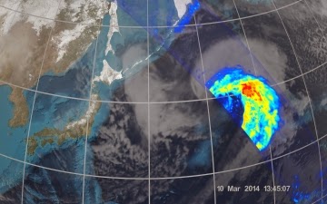
It shows the storm as it appeared on Oct. 28, 2012. 

Credit: NASA /SSAI, Hal Pierce

Orbiting at an angle to the equator that covers 35 degrees north to 35 degrees south of the equator, TRMM carries five instruments that collectively measure the intensity of rainfall, characteristics of the water vapour and clouds, and lightning associated with the rain events.

One of the instruments, the Precipitation Radar, built by JAXA, is the first precipitation radar flown in space.

It returns images of storms that for the first time have revealed close-up, 3-D views of how rain bands in tropical cyclones develop, potentially indicating how strong the storms might become.

Monday, September 8, 2014

NASA Launches New Era of Earth Science from Space Station

Image Credit: NASA

The launch of a NASA ocean winds sensor to the International Space Station (ISS) this month inaugurates a new era of Earth observation that will leverage the space station's unique vantage point in space.

Before the end of the decade, six NASA Earth science instruments will be mounted to the station to help scientists study our changing planet.

The first NASA Earth-observing instrument to be mounted on the exterior of the space station will launch from Cape Canaveral Air Force Station, Florida, on the next SpaceX Commercial Resupply Services flight, currently targeted for no earlier than Sept. 19.

Graphic of ISS-RapidScat on ISS
ISS-RapidScat will monitor ocean winds for climate research, weather predictions and hurricane monitoring from the space station.

The second instrument is the Cloud-Aerosol Transport System (CATS), a laser instrument that will measure clouds and the location and distribution of airborne particles such as pollution, mineral dust, smoke, and other particulates in the atmosphere.

Graphic of CATS on ISS
CATS will follow ISS-RapidScat on the fifth SpaceX space station resupply flight, targeted for December.

"We're seeing the space station come into its own as an Earth-observing platform," said Julie Robinson, chief scientist for the International Space Station Program at NASA's Johnson Space Center in Houston.

"It has a different orbit than other Earth remote sensing platforms. It’s closer to Earth, and it sees Earth at different times of day with a different schedule."

"That offers opportunities that complement other Earth-sensing instruments in orbit today."

The space station-based instruments join a fleet of 17 NASA Earth-observing missions currently providing data on the dynamic and complex Earth system.

GPM image of Precipitation
ISS-RapidScat and CATS follow the February launch of the Global Precipitation Measurement Core Observatory (GPM), a joint mission with the Japan Aerospace Exploration Agency (JAXA), and the July launch of the Orbiting Carbon Observatory-2 (OCO-2), making 2014 one of the busiest periods for new NASA Earth science missions in more than a decade.

Most of the agency’s free-flying, Earth-observing satellites orbit the planet over the poles at altitudes higher than 400 miles in order to gather data from all parts of the planet.

Although the space station does not pass over Earth’s polar regions, its 240-mile high orbit does offer logistical and scientific advantages.

"With the space station we don't have to build a spacecraft to gather new data, it's already there,” said Stephen Volz, associate director of flight programs in the Earth Science Division at NASA Headquarters in Washington.

“The orbit enables rare, cross-disciplinary observations when the station flies under another sensor on a satellite. Designing instruments for the space station also gives us a chance to do high-risk, high-return instruments in a relatively economical way."

The data provided by ISS-RapidScat will support weather and marine forecasting, including tracking storms and hurricanes.

The station's orbit will allow the instrument to make repeated, regular observations over the same locations at different times of day, providing the first near-global measurements of how winds change throughout the day.

ISS-RapidScat was built by NASA's Jet Propulsion Laboratory (JPL) in Pasadena, California.

CATS is a laser remote-sensing instrument, or lidar, that measures clouds and tiny aerosol particles in the atmosphere.

These atmospheric components play a critical part in understanding how human activities such as pollution and fossil fuel burning contribute to climate change.

CATS was built by NASA's Goddard Space Flight Center in Greenbelt, Maryland.

Friday, September 5, 2014

International Global Precipitation Measurement Mission (GPM) Data Goes Public


On March 17, 2014 the Global Precipitation Measurement (GPM) mission's Core Observatory flew over the East coast's last snow storm of the 2013-2014 winter season.

This was also one of the first major snow storms observed by GPM shortly after it was launched on February 27, 2014.

The GPM Core Observatory carries two instruments that show the location and intensity of rain and snow, which defines a crucial part of the storm structure - and how it will behave.

The GPM Microwave Imager sees through the tops of clouds to observe how much and where precipitation occurs, and the Dual-frequency Precipitation Radar observes precise details of precipitation in 3-dimensions.

For forecasters, GPM's microwave and radar data are part of the toolbox of satellite data, including other low Earth orbit and geostationary satellites, that they use to monitor tropical cyclones and hurricanes.

One of the first storms observed by the NASA/JAXA GPM Core Observatory on March 17, 2014, in the eastern United States revealed a full range of precipitation, from rain to snow. 

Image courtesy NASA/JAXA.

The most accurate and comprehensive collection of rain, snowfall and other types of precipitation data ever assembled now is available to the public.

This new resource for climate studies, weather forecasting, and other applications is based on observations by the Global Precipitation Measurement (GPM) Core Observatory, a joint mission of NASA and the Japan Aerospace Exploration Agency (JAXA), with contributions from a constellation of international partner satellites.

The GPM Core Observatory, launched from Japan on Feb. 27, carries two advanced instruments to measure rainfall, snowfall, ice and other precipitation.

The advanced and precise data from the GPM Core Observatory are used to unify and standardize precipitation observations from other constellation satellites to produce the GPM mission data.

These data are freely available through NASA's Precipitation Processing System at Goddard Space Flight Center in Greenbelt, Maryland.

"We are very pleased to make all these data available to scientists and other users within six months of launch," said Ramesh Kakar, GPM program scientist in the Earth Science Division at NASA Headquarters, Washington.

Instruments on the GPM Core Observatory and partner satellites measure energy naturally emitted by liquid and frozen precipitation. Scientists use computer programs to convert these data into estimates of rain and snowfall.

The individual instruments on the partner satellites collect similar data, but the absolute numbers for precipitation observed over the same location may not be exactly the same.

The GPM Core Observatory's data are used as a reference standard to smooth out the individual differences, like a principal violinist tuning the individual instruments in an orchestra.

The result is data that are consistent with each other and can be meaningfully compared. With the higher sensitivity to different types of precipitation made possible by the GPM Core Observatory's Microwave Imager (GMI) and Dual-frequency Precipitation Radar (DPR), scientists can for the first time accurately measure the full range of precipitation from heavy rain to light rain and snow.

The instruments are designed not only to detect rain and snow in the clouds, but to measure the size and distribution of the rain particles and snowflakes.

This information gives scientists a better estimate of water content and a new perspective on winter storms, especially near the poles where the majority of precipitation is snowfall.

"With this GPM mission data, we can now see snow in a way we could not before," said Gail Skofronick-Jackson, GPM project scientist at Goddard Space Flight Center.

"Cloud tops high in the atmosphere have ice in them. If the Earth's surface is above freezing, it melts into rain as it falls. But in some parts of the world, it's cold enough that the ice and snow falls all the way to the ground."

Wednesday, March 26, 2014

NASA JAXA GPM: First Images from GPM - Pacific Ocean Cyclone

NASA and the Japan Aerospace Exploration Agency (JAXA) have released the first images captured by their newest Earth-observing satellite, the Global Precipitation Measurement (GPM) Core Observatory, which launched into space Feb. 27.

The images show precipitation falling inside a March 10 cyclone over the northwest Pacific Ocean, approximately 1,000 miles east of Japan.


On March 10, the Core Observatory passed over an extra-tropical cyclone about 1,055 miles (1,700 kilometers) due east of Japan's Honshu Island. Satellite data shows the full range of precipitation in the storm.

Image Credit: NASA's Goddard Space Flight Center

Thursday, March 6, 2014

NASA JAXA GPM: Earth-based measurements needed to calibrate newest weather satellite

After Atlanta was paralyzed by a rare snowstorm, many fingers were pointed assigning blame for the resulting traffic catastrophe, including at least one aimed at imprecise weather predictions.

"The governor of Georgia said that they thought the heavier snowfall was going to be south of the city," said Ana Barros, professor of civil and environmental engineering at Duke University.

"But there's a lot of uncertainty in those predictions because we don't really understand the fine details of complex storm systems. We don't know how to model these processes at high spatial resolutions."

Ana Barros
This summer, Barros and her colleagues will conduct the first field mission with a new satellite system intended to fill in those knowledge gaps.

On Feb. 27, NASA and Japan's national space agency (JAXA) launched the core satellite for their new Global Precipitation Measurement (GPM) mission from Japan's Tanegashima Space Center.

GPM is an international satellite mission designed to provide more detailed measurements of rain and snow over a wider range of the globe than previously possible.

Not only will the satellite have more precise instrumentation than its predecessors; its orbit will allow researchers to study rainfall at higher latitudes at higher spatial and temporal resolutions.

The data it collects will help unify measurements made by partner satellites and add to science's understanding of how weather works.

Before meteorologists can start plugging the new data in to their weather models, however, researchers have to make sure they can accurately interpret the GPM measurements.

The upcoming field mission, based in the mountains of western North Carolina and led by Duke engineers, will help achieve this by comparing satellite readings with those taken simultaneously from multiple aircraft and ground sensors.

Besides calibrating the new satellite, the campaign will help improve how precipitation processes are represented in forecast calculations.

It will also provide data and inform models used to address critical water management issues in mountainous regions.

"The campaign that we are running will obtain very high-resolution data of precipitation and the microphysics of storm systems in mountainous regions," said Barros.

"The end goal is to improve weather predictions and climate models."

Saturday, March 1, 2014

NASA-JAXA GPM Launch: Mission to Measure Global Rain, Snow

A Japanese H-IIA rocket with the NASA-Japan Aerospace Exploration Agency (JAXA) Global Precipitation Measurement (GPM) Core Observatory onboard, is seen launching from the Tanegashima Space Center in Tanegashima, Japan. 

Image Credit: NASA/Bill Ingalls

The Global Precipitation Measurement (GPM) Core Observatory, a joint Earth-observing mission between NASA and the Japan Aerospace Exploration Agency (JAXA), thundered into space at 10:37 a.m. PST Thursday, Feb. 27 (3:37 a.m. JST Friday, Feb. 28) from Japan.

The four-ton spacecraft launched aboard a Japanese H-IIA rocket from Tanegashima Space Center on Tanegashima Island in southern Japan.

The GPM spacecraft separated from the rocket 16 minutes after launch, at an altitude of 247 miles (398 kilometers). The solar arrays deployed 10 minutes after spacecraft separation, to power the spacecraft.

"With this launch, we have taken another giant leap in providing the world with an unprecedented picture of our planet's rain and snow," said NASA Administrator Charles Bolden.

"GPM will help us better understand our ever-changing climate, improve forecasts of extreme weather events like floods, and assist decision makers around the world to better manage water resources."

The GPM Core Observatory will take a major step in improving upon the capabilities of the Tropical Rainfall Measurement Mission (TRMM), a joint NASA-JAXA mission launched in 1997 and still in operation.

While TRMM measured precipitation in the tropics, the GPM Core Observatory expands the coverage area from the Arctic Circle to the Antarctic Circle. GPM will also be able to detect light rain and snowfall, a major source of available fresh water in some regions.


To better understand Earth's weather and climate cycles, the GPM Core Observatory will collect information that unifies and improves data from an international constellation of existing and future satellites by mapping global precipitation every three hours.

"It is incredibly exciting to see this spacecraft launch," said GPM Project Manager Art Azarbarzin of NASA's Goddard Space Flight Center in Greenbelt, Md. "This is the moment that the GPM team has been working toward since 2006.

"The GPM Core Observatory is the product of a dedicated team at Goddard, JAXA and others worldwide."

"Soon, as GPM begins to collect precipitation observations, we'll see these instruments at work providing real-time information for the scientists about the intensification of storms, rainfall in remote areas and so much more."

Wednesday, January 22, 2014

NASA-NOAA Suomi NPP VIIRS satellite sensor: More precise hurricane forecasts

Tropical Storm Flossie imagery in July 2013 from Suomi NPP’s VIIRS Day-Night band revealing that the storm shifted more to the north, sparing the big island of Hawaii from a direct hit, but bringing the islands of Oahu, Molokai and Maui into a tropical storm warning area. 

Credit: NOAA

The ability to use satellites to locate a storm that could evolve into a severe storm or hurricane will likely become more accurate for this year's Atlantic hurricane season beginning June 1.

By then, the National Oceanic and Atmospheric Administration's (NOAA), weather forecasters will be able to further improve the use of sensors aboard the NASA-NOAA Suomi National Polar-orbiting Partnership satellite (Suomi NPP).

U.S. Polar Environmental satellites such as Suomi NPP provide complete global coverage twice daily, while NOAA/NASA Geostationary Operational Environmental Satellites offer imagery over a fixed area.

To improve the ability to better find and track hurricanes, NOAA scientists are finding ways to incorporate data from Suomi NPP's Visible Infrared Imaging Radiometer Suite, VIIRS sensor, that allows observations of Earth's atmosphere and surface during nighttime hours and offers enhanced capability to see through clouds.

VIIRS provides many advances over previous operational imagers and advances compared to its research predecessor, the Moderate Resolution Imaging Spectroradiometers (MODIS) currently operating on NASA's Aqua and Terra satellites.

It is these advances in polar imagery that will give forecasters a new tool to improve their predictions.

Similarly, the radar on board the NASA/Japan Aerospace Exploration Agency Tropical Rainfall Measuring Mission (TRMM) satellite has the capability to see through and distinguish between precipitating cumulus and the cirrus clouds which TRMM's infrared sensor also detects.

The next-generation of these sensors is set to launch from Japan next month aboard the Global Precipitation Measurement (GPM) satellite.

The information to track storms comes from satellites surface stations, weather balloons, radar and aircraft.

Most current satellites provide important information during day and night, although observations in the visible part of the spectrum are limited at night.

That is where VIIRS has an advantage. The VIIRS day-night band is sensitive enough to provide storm information even under limited moonlight conditions, a major advancement for storm analysis.

The Advanced Technology Microwave Sounder (ATMS) sensor aboard Suomi NPP also provides temperature and water vapour measurements with greater accuracy than similar microwave instruments onboard earlier satellites.

In relatively clear areas away from the storm center and in the eye of intense storms, the Cross-track Infrared Sensor (CrIS), also on Suomi NPP, enhances ATMS temperature and moisture information by providing measurements with even greater vertical and horizontal resolution.

Installation of the CrIS instrument. Credit: Ball Aerospace

Friday, December 27, 2013

NASA and JAXA Announce Launch Date for Global Precipitation Satellite GPM

Environmental research and weather forecasting are about to get a significant technology boost as NASA and the Japan Aerospace Exploration Agency (JAXA) prepare to launch a new satellite in February.

NASA and JAXA selected 1:07 p.m. to 3:07 p.m. EST Thursday, Feb. 27 (3:07 a.m. to 5:07 a.m. JST Friday, Feb. 28) as the launch date and launch window for a Japanese H-IIA rocket carrying the Global Precipitation Measurement (GPM) Core Observatory satellite from JAXA's Tanegashima Space Center.

GPM is an international satellite mission that will provide advanced observations of rain and snowfall worldwide, several times a day to enhance our understanding of the water and energy cycles that drive Earth's climate.

The data provided by the Core Observatory will be used to calibrate precipitation measurements made by an international network of partner satellites to quantify when, where, and how much it rains or snows around the world.

"Launching this core observatory and establishing the Global Precipitation Measurement mission is vitally important for environmental research and weather forecasting," said Michael Freilich, director of NASA's Earth Science Division in Washington.

"Knowing rain and snow amounts accurately over the whole globe is critical to understanding how weather and climate impact agriculture, fresh water availability, and responses to natural disasters."

"We will use data from the GPM mission not only for Earth science research but to improve weather forecasting and respond to meteorological disasters," said Shizuo Yamamoto, executive director of JAXA.

"We would also like to aid other countries in the Asian region suffering from flood disasters by providing data for flood alert systems. Our dual-frequency precipitation radar, developed with unique Japanese technologies, plays a central role in the GPM mission."

The GPM spacecraft oriented for inspections after its arrival in the clean room at Tanegashima Space Center. 

Image Credit: NASA / Michael Starobin

The GPM Core Observatory builds on the sensor technology developed for the TRMM mission, with two innovative new instruments.

The GPM Microwave Imager, built by Ball Aerospace and Technology Corp., Boulder, Colo., will observe rainfall and snowfall at 13 different frequencies.

The Dual-frequency Precipitation Radar, developed by JAXA with the National Institute of Information and Communication Technology in Tokyo, transmits radar frequencies that will detect ice and light rain, as well as heavier rainfall.

It also will be able to measure the size and distribution of raindrops, snowflakes and ice particles.

Friday, December 6, 2013

Global Precipitation Measurement (GPM) Core Observatory: Final checkout

Following arrival in a cleanroom at the Tanegashima Space Center in Japan, the Global Precipitation Measurement (GPM) core observatory was attached to a custom-designed satellite mount which allowed the NASA team on-site to perform preliminary inspections and evaluations of the spacecraft. 

Credit: NASA/Michael Starobin 

Following the Global Precipitation Measurement Core Observatory's arrival at the Tangashema Space Center in Japan, efforts by the NASA and Japan Aerospace Exploration Agency team will now focus on final checkouts and preparation for launch in early 2014.

After the satellite was removed from its transportation container, the NASA team conducted preliminary inspections and found everything to be in very good shape.

None of the systems that monitored the satellite's condition during the move from NASA Goddard to Japan showed any thing outside of normal levels. This means there will be no need to re-test the deployable parts of the observatory.

The anatomy of a raindrop. Credit: NASA

This month, the number of NASA personnel at the Japanese launch site will increase from the normal staff of 50 to approximately 80-90 to allow 24/7 operations during Comprehensive Performance Test (CPT).

This activity involves engineers making final preparations to the satellite and verifying that all the elements of the observatory are ready to support mission objectives.

Pre-CPT work this week included testing of both the flight and spare batteries. The spare batteries have been moved into storage and flight ones are now installed on the observatory.

Formal CPT activity is scheduled to begin on next Monday, Dec. 9, 2013 and all scheduled work should be completed in plenty of time for the NASA group to return home for Christmas.