Showing posts with label Pacific Ocean. Show all posts

Thursday, September 25, 2014

El Niño 2014: Ocean Circulation - Signs of a modest return

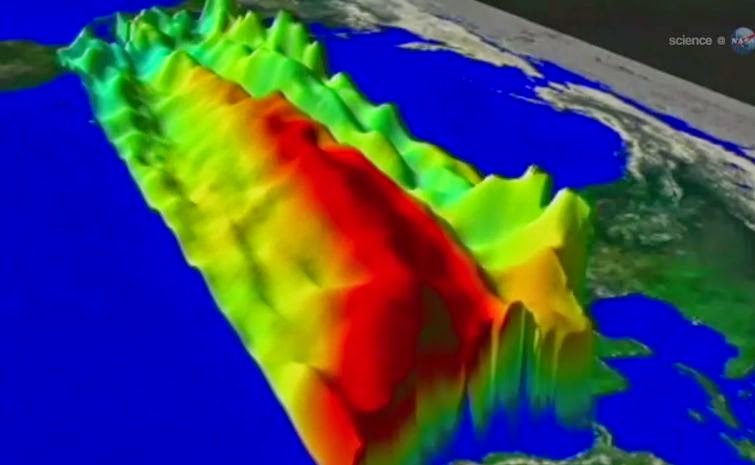
The image shows Kelvin waves of high sea level (red/yellow) crossing the Pacific Ocean at the equator. 

The waves can be related to El Niño events. Green indicates normal sea level, and blue/purple areas are lower than normal. 

Data are from the NASA /European Jason-2 satellite, collected Sept. 13-22, 2014. 

Image credit: NASA/JPL-Caltech

Prospects have been fading for an El Niño event in 2014, but now there's a glimmer of hope for a very modest comeback.

Scientists warn that unless these developing weak-to-modest El Niño conditions strengthen, the drought-stricken American West shouldn't expect any relief.

The latest sea-level-height data from the NASA /European Ocean Surface Topography Mission (OSTM) /Jason-2 satellite mission show a pair of eastward-moving waves of higher sea level, known as Kelvin waves, in the Pacific Ocean, the third such pair of waves this year.

Now crossing the central and eastern equatorial Pacific, these warm waves appear as the large area of higher-than-normal sea surface heights (warmer-than-normal ocean temperatures) hugging the equator between 120 degrees west and the International Dateline.

The Kelvin waves are traveling eastward and should arrive off Ecuador in late September and early October.

A series of larger atmospheric "west wind bursts" from February through May 2014 triggered an earlier series of Kelvin waves that raised hopes of a significant El Niño event.

Just as the warming of the eastern equatorial Pacific by these waves dissipated, damping expectations for an El Niño this year, these latest Kelvin waves have appeared, resuscitating hopes for a late arrival of the event.

For an overview of 2014's El Niño prospects and Kelvin waves, please see: phys.org/news/2014-05-el-nino.html

This latest image highlights the processes that occur on time scales of more than a year but usually less than 10 years, such as El Niño and La Niña.

The image also highlights faster ocean processes such as Kelvin waves. As Patzert says, "Jason-2 is a fantastic Kelvin wave counter."

These processes are known as the interannual ocean signal. To show that signal, scientists refined data for this image by removing trends over the past 21 years, seasonal variations and time-averaged signals of large-scale ocean circulation.

For a more detailed explanation of what this type of image means, visit: sealevel.jpl.nasa.gov/science/… lninopdo/latestdata/

For a time sequence of the evolution of the 2014 El Nino, visit: sealevel.jpl.nasa.gov/science/… /latestdata/archive/

Thursday, September 4, 2014

Scientists discover seamount in Pacific ocean

Three-dimensional view of the southwest side of the seamount with 23-degree slopes. 

Credit: University of New Hampshire


University of New Hampshire scientists on a seafloor mapping mission have discovered a new seamount near the Johnson Atoll in the Pacific Ocean.

The summit of the seamount rises 1,100 meters from the 5,100-meter-deep ocean floor.

The seamount was discovered in August when James Gardner, research professor in the UNH-NOAA Center for Coastal and Ocean Mapping/Joint Hydrographic Center, was leading a mapping mission aimed at helping delineate the outer limits of the U.S. continental shelf.

Working aboard the R/V Kilo Moana, an oceanographic research ship owned by the U.S. Navy and operated by the University of Hawaii, Gardner and his team were using multibeam echosounder technology to create detailed images of the seafloor when, late at night, the seamount appeared "out of the blue." The team was able to map the conical seamount in its entirety.

The yet-unnamed seamount, located about 300 kilometers southeast of the uninhabited Jarvis Island, lies in one of the least explored areas of the central Pacific Ocean. Because of that, Gardner was not particularly surprised by the discovery.

"These seamounts are very common, but we don't know about them because most of the places that we go out and map have never been mapped before," he says.

Since only low-resolution satellite data exists for most of the Earth's seafloor, many seamounts of this size are not resolved in the satellite data but advanced multibeam echosounder missions like this one can resolve them. "Satellites just can't see these features and we can," Gardner adds.

While the mapping mission was in support of the U.S. Extended Continental Shelf Task Force, a multi-agency project to delineate the outer limits of the U.S. continental shelf, the volcanic seamount lies within the U.S. exclusive economic zone.

That means the U.S. has jurisdiction of the waters above it as well as the sediment and rocks of the seamount itself.

Three-dimensional view of the seamount area (southeast point of view and 3.5x vertical exaggeration) showing two volcanoes, in the foreground, with the discovered seamount in the background. 

Credit: University of New Hampshire


The seamount's impact remains unknown – for now. It's too deep (its summit lies nearly 4,000 meters beneath the surface of the ocean) to be a navigation hazard or to provide rich fisheries. "It's probably 100 million years old," Gardner says, "and it might have something in it we may be interested in 100 years from now."

Wednesday, March 26, 2014

NASA JAXA GPM: First Images from GPM - Pacific Ocean Cyclone

NASA and the Japan Aerospace Exploration Agency (JAXA) have released the first images captured by their newest Earth-observing satellite, the Global Precipitation Measurement (GPM) Core Observatory, which launched into space Feb. 27.

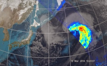
The images show precipitation falling inside a March 10 cyclone over the northwest Pacific Ocean, approximately 1,000 miles east of Japan.


On March 10, the Core Observatory passed over an extra-tropical cyclone about 1,055 miles (1,700 kilometers) due east of Japan's Honshu Island. Satellite data shows the full range of precipitation in the storm.

Image Credit: NASA's Goddard Space Flight Center

Sunday, February 3, 2013

Russian Rocket failure: US Satellite Plunges into Pacific Ocean

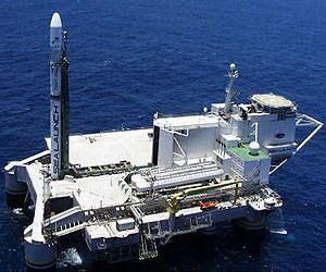
A Russian rocket carrying a US telecoms satellite plunged into the Pacific Ocean on Friday only moments after being launched from a mobile sea platform in Moscow's latest space failure.

The rocket may have veered off course from the moment of take-off because of heavy waves battering the former northern seas oil platform, initial reports said.

The Intelsat-27's loss means the giant Boeing aerospace corporation would for now be unable to fit the final piece of a constellation mean to provide TV feeds across Europe and the United States.

"There was an accident during the Zenit-3L rocket launch," a source at the Energia corporation that makes the Zenit-3SL rocket used to lift up Intelsat satellites told AFP.

"The rocket fell into the Pacific Ocean."

Officials said no one was hurt on the huge Odyssey Sea Launch platform that was once stationed off the oil-rich coast of Norway before being tugged to the Pacific by an international consortium called Sea Launch.

Energia chief Vitaly Lopota said the Russian rocket's engine appeared to fail less than a minute after the evening take-off but the reason was still unknown reason.

"We had an abnormal situation -- the emergency shutdown of the first stage engine," Lopota told the state RIA Novosti news agency.

"It happened 50 seconds into the flight. We are now looking into what happened."

Several Russian media reports said the platform itself was unstable at the time of the launch because of heavy weather.

Sources said the Zenit had purposefully steered itself as far away from the Odyssey as possible -- instead of going straight up -- because the engines detected a problem and were programmed to save the ground crew.

"The rockets detected an abnormal situation linked to platform instability from the very start, and then switched the engines over (to operations) aimed at steering the rocket away from the platform," a space industry source reported.

Sea Launch has been using the deep-sea platform to perform commercial operations since 1999. There had been only two complete failures out of the 34 missions conducted prior to Friday's launch.

Having emerged from bankruptcy protection in October 2010 after years of financial difficulties, Sea Launch will be keen to prove that the accident was an anomaly that should not affect future launches, space analysts said.

"This accident is very unpleasant for Sea Launch, which only recently started to repair its reputation on the commercial space services market," said Moscow's Space News magazine editor Igor Marinin.

Russia's space programme is under close scrutiny because it provides the world's only manned link to the International Space Station (ISS).

Sunday, August 12, 2012

NASA Aqua Image: Cloud Patterns over South Sandwich Islands

Credit: NASA

A volcano in the South Sandwich islands creates a pattern in the clouds over the Southern Ocean in this photo taken by NASA's Aqua satellite

Tuesday, March 27, 2012

Express AM4 Destroyed as Effort To Save Russian Satellite Shunned

Express AM-4 satellite. Credit: EADS Astrium photo

The Russian Express AM4 communications satellite, placed into a bad orbit after a rocket failure during its August launch, was intentionally crashed into the Pacific Ocean March 25 despite an attempt to save the craft to serve Antarctic scientists, Spaceflight Now reports.

Polar Broadband Systems Ltd. wanted to purchase the satellite and raise its orbit so that it could provide broadband coverage to researchers in the South Pole region, said company co-founder Bill Readdy, a former space shuttle commander and NASA manager. But the company’s phone calls to the Russian space agency and Express AM4’s insurance underwriter in recent days were not answered, Readdy said.

Moving the satellite into an orbit high over Antarctic research sites would have provided broadband coverage of the South Pole region for more than 14 hours per day, Readdy said.

Saturday, February 4, 2012

Saviour of the Coral Reefs: Sea Cucumbers

Sea cucumbers can save coral reefs from the impact of ocean acidification on their growth, a group of scientists working on the impact of climate change on coral reefs have revealed in a recent study.

The research, published in the latest issue of the Journal of Geophysical Research, suggests that calcium carbonate released from the digestion of sand by sea cucumbers, one of the largest invertebrates found on tropical reefs, is a key component for the survival of coral reefs.

Maria Byrne, professor and director, One Tree Island Research Station of the University of Sydney on the Great Barrier Reef, said that coral reefs must accumulate CaCO3 at a rate greater than or equal to the CaCO3 that is eroded from the reef to survive.

Byrne, who is the lead author of the research, writes in the journal: "The research at One Tree Island showed that in a healthy reef, dissolution of calcium carbonate sediment by sea cucumbers and other bio-eroders appears to be an important component of the natural calcium carbonate turnover."

Sunday, January 15, 2012

Russian Phobos-Grunt Mars probe falls in Pacific Ocean


Doomed Russian Phobos-Grunt Mars probe that's been stuck in Earth orbit for two months has crashed down in the Pacific Ocean on late Sunday.

"Phobos-Grunt fragments have crashed down in the Pacific Ocean," Russia's Defense Ministry official Alexei Zolotukhin told RIA Novosti, adding that the fragments fell in 1,250 kilometers to the west of the island of Wellington.

The spacecraft fell at about 21:45 on Sunday Moscow time [17:45 GMT].

As of 20.15 Sunday, the spacecraft was moving in the near-Earth orbit with an altitude that varied between 113.8 km at perigee and 133.2 km at apogee, the Russian space agency Roscosmos said.

Saturday, January 7, 2012

Tuesday, December 20, 2011

Volcanic island of Onekota in Pacific Ocean

Volcanic island of Onekota on 17th May 2011. 

Onekota Island is located towards the north end of the Kuril Islands chain in the Sea of Okhotsk in the northwest Pacific Ocean.
Picture: BARCROFT

Wednesday, December 7, 2011

Oceans' deepest depth re-measured

US scientists have mapped the deepest part of the world's oceans in greater detail than ever before.

The Mariana Trench in the western Pacific runs for about 2,500km and extends down to 10,994m.

This measurement for the deepest point - known as Challenger Deep - is arguably the most precise yet.

The survey, conducted by the Center for Coastal and Ocean Mapping (CCOM), was completed to help determine the exact extent of US waters in the region.

"We mapped the entire trench, from its northern end at Dutton Ridge, all the way to where it becomes the Yap Trench in the south," explained Dr Jim Gardner from CCOM, which is based at the University of New Hampshire.

"We used a multibeam echosounder mounted on a US Navy hydrographic ship. This instrument allows you to map a swath of soundings perpendicular to the line of travel of the ship. It's like mowing the grass. And we were able to map the trench at a 100m resolution," he told BBC News.

The distance to the bottom of Challenger Deep has an error associated with it of about plus or minus 40m.

The figure of 10,994m is slightly less than some other recent measurements in the modern era, but they are all broadly similar.

A location in the trench about 200km to the east of Challenger goes almost as far down. This spot, known as HMRG Deep, has a depth of 10,809m.

It is extraordinary to think that both Challenger and HMRG extend deeper below sea level than Mount Everest rises above it.

Dr Gardner said his team's survey put a huge effort into getting the "sound speed profile" of the water column correct - this measure of how the echosounding signals speed and slow as they descend is the largest source of error in the measurement.

He presented the results of the mapping here at the 2011 American Geophysical Union (AGU) Fall Meeting, the world's largest annual gathering of Earth and planetary scientists.
Challenger Deep
The US State Department funded the study because it wants to know whether the exclusive economic zone encompassing the American territories of Guam and the Northern Mariana Islands can be pushed out beyond its current limit of 200 nautical miles (370km).

This may be possible if the shape of the seafloor fulfils certain requirements under the United Nations Convention on the Law of the Sea.

But the data also has high scientific interest in that it gives geologists a clearer picture of the structures in one of the most fascinating subduction zones on Earth.

Saturday, March 12, 2011

NOAA Image of Japan tsunami and earthquake aftermath

An energy map provided by the National Oceanic and Atmospheric Administration (NOAA) shows the intensity of the tsunami in the Pacific Ocean caused by the magnitude 8.9 earthquake which struck Japan on March 11, 2011. 

Photograph: Ho/REUTERS

Tuesday, January 25, 2011

Onekotan Island, Kuril Islands, Russia

Snow cover highlights the calderas and volcanic cones that form the northern and southern ends of Onekotan Island, part of the Russian Federation in the western Pacific Ocean.

Calderas are depressions formed when a volcano empties its magma chamber in an explosive eruption and then the overlaying material collapses into the evacuated space.

In this astronaut photograph from the International Space Station, the northern end of the island (image right) is dominated by the Nemo Peak volcano, which began forming within an older caldera approximately 9,500 years ago. The last recorded eruption at Nemo Peak occurred in the early 18th century.

The southern end of the island was formed by the 7.5 kilometer (4.6 mile) wide Tao-Rusyr Caldera. The caldera is filled by Kal’tsevoe Lake and Krenitzyn Peak, a volcano that has only erupted once in recorded history (in 1952).

Extending between northeastern Japan and the Kamchatka Peninsula of Russia, the Kurils are an island arc located along the Pacific “Ring of Fire.” Island arcs form along an active boundary between two tectonic plates, where one plate is being driven beneath the other (subduction).

Magma generated by the subduction process feeds volcanoes—which eventually form volcanic islands over the subduction boundary.

Thursday, September 16, 2010

La Niña continues to strengthen in the Pacific Ocean

La Niña continues to strengthen in the Pacific Ocean, as shown in the latest satellite data of sea surface heights from the NASA/European Ocean Surface Topography Mission/Jason-2 satellite. The image is based on the average of 10 days of data centred on Sept. 3, 2010. Higher (warmer) than normal sea surface heights are indicated by yellows and reds, while lower (cooler) than normal sea surface heights are depicted in blues and purples. Green indicates near-normal conditions. According to NASA climatologist Bill Patzert 'This La Niña could deepen the drought in the already parched Southwest and could also worsen conditions that have fuelled Southern California's recent deadly wildfires'

La Niña continues to strengthen in the Pacific Ocean, as shown in the latest satellite data of sea surface heights from the NASA/European Ocean Surface Topography Mission/Jason-2 satellite.

The image is based on the average of 10 days of data centred on Sept. 3, 2010. Higher (warmer) than normal sea surface heights are indicated by yellows and reds, while lower (cooler) than normal sea surface heights are depicted in blues and purples.

Green indicates near-normal conditions. According to NASA climatologist Bill Patzert "This La Niña could deepen the drought in the already parched Southwest and could also worsen conditions that have fuelled Southern California's recent deadly wildfires"

Picture: AP / NASA / JPL

Wednesday, May 26, 2010

Manta ray 16ft wide

A diver swims in the shadow of a 16-feet wide manta ray.

Diver and professional photographer Franco Banfi snapped this in the water off the coast of the Socorro and San Benedicto Islands in the Pacific Ocean

Picture: FRANCO BANFI / SOLENT