Showing posts with label images. Show all posts

Friday, January 16, 2015

SpaceX Release images of Falcon 9 Launcher crash - Video

Video of SpaceX Falcon 9's Lower Stage Launcher crash 

Credit: SpaceX


SpaceX Falcon 9's Lower Stage Launcher crash.

Credit: Space X

SpaceX Falcon 9's Lower Stage Launcher crashes back onto the deck of the floating platform that was intended as its safe haven.

Elon Musk, CEO of SpaceX, has released pictures from his firms recent failed attempt to land a rocket on a boat.

The images show the first stage of SpaceX's Falcon 9 rocket hitting the boat at a 45 degree angle before exploding.

Looking closely at the images above, you can see the steerable fins at the top of the rocket, designed to bring it in for a safe landing.

Musk has previously said that the fins ran out of hydraulic fluid just before landing, meaning the rocket lost control, so SpaceX will be adding more fluid for its next attempt.

The rocket came in too fast, destroying its landing legs, and then the leftover fuel ignited and it exploded (see below).

"Full RUD (rapid unscheduled disassembly) event. Ship is fine minor repairs. Exciting day!" tweeted Musk.

Monday, November 3, 2014

NASA’s LRO Spacecraft Captures Images of LADEE’s Impact Crater

This image shows the area of the LADEE impact after spacecraft's planned impact into the eastern rim of Sundman V crater. 

Image Credit: NASA/Goddard/Arizona State University

NASA’S Lunar Reconnaissance Orbiter (LRO) spacecraft has spied a new crater on the lunar surface; one made from the impact of NASA’s Lunar Atmosphere and Dust Environment Explorer (LADEE) mission.

“The Lunar Reconnaissance Orbiter Camera (LROC) team recently developed a new computer tool to search Narrow Angle Camera (NAC) before and after image pairs for new craters, the LADEE impact event provided a fun test, said Mark Robinson, LROC principal investigator from Arizona State University in Tempe.

“As it turns there were several small surface changes found in the predicted area of the impact, the biggest and most distinctive was within 968 feet (295 meters) of the spot estimated by the LADEE operations team. What fun!”

The LADEE mission ended on April 18, 2014, with the spacecraft’s planned impact into the eastern rim of Sundman V crater on the far side of the moon.

LRO has taken an image of the LADEE impact site on the eastern rim of Sundman V crater.

The image was created by ratioing two images, one taken before the impact and another afterwards. 

The bright area highlights what has changed between the time of the two images, specifically the impact point and the ejecta.

Image Credit: NASA /Goddard /Arizona State University

LADEE's engines fired April 11, 2014, to perform a final orbital maintenance maneuver and adjust to guarantee it would impact on the farside of the moon and away from the Apollo landing sites.

Over a seven-day period, LADEE's orbit decreased and the spacecraft orbited very low to the surface and close to the walls of lunar craters and mountain ridges to give the team a chance to collect valuable science data.

Finally, LADEE impacted the eastern rim of Sundman V crater on April 18. The impact site is about half a mile (780 meters) from the crater rim with an altitude of about 8,497 feet (2,590 meters) and was only about two tenths of a mile (300 meters) north of the location mission controllers predicted based on tracking data.

The impact crater is small, less than ten feet (three meters) in diameter, barely resolvable by the LROC NAC.

The crater is small because the spacecraft, compared to most celestial impacts, was not traveling very fast, approximately 3,800 miles per hour (1,699 meters per second) and had a low mass and a low density.

The size of the impact crater made it hard to identify among the myriad of small fresh craters on the lunar surface. Images acquired of the impact region before the impact, were compared with images obtained after the impact to identify the crater.

Artist concept of the Lunar Reconnaissance Orbiter with Apollo mission imagery of the moon in the background.

Image Credit: NASA's Goddard Space Flight Center

Since the NAC images are so large (250 mega-pixels) and the new crater is so small, the LROC team co-registered the before and after images (called a temporal pair) and then divided the before image by the after image. By doing this, changes to the surface become evident.

The ejecta from the impact forms a triangular pattern primarily downrange to the west, extending about 656-984 feet (200-300 meters) from the impact site.

There is also a small triangular area of ejecta up range but it extends only about 66-98 feet (20-30 meters).

The ejecta pattern is oriented northwest, consistent with the direction the spacecraft was traveling when it impacted the surface.

"I'm happy that the LROC team was able to confirm the LADEE impact point," said Butler Hine, LADEE project manager at Ames Research Center in Moffett Field, California.

"It really helps the LADEE team to get closure and know exactly where the product of their hard work wound up."

Monday, October 20, 2014

Vintage Comet 67P/Churyumov–Gerasimenko

It was 45 years ago when astronomer Klim Churyumov and Svetlana Gerasimenko, one of his researchers, unwittingly began a new chapter in the history of space exploration.

During a comet-hunting expedition to Alma-Ata Observatory, Kazakhstan, they discovered the bizarre, ice-rich object, subsequently named Comet 67P/Churyumov–Gerasimenko, that is now under close scrutiny by ESA’s Rosetta spacecraft.

In November 2014 it is hoped that more secrets will be revealed when Rosetta’s Philae attempts the first soft-landing on the nucleus of a comet.

These two images, taken with a wide-angle Schmidt telescope, were exposed a short time apart during the historic expedition.

The pair of photographic plates, taken by Klim Churyumov on 21 September 1969, shows a fuzzy object (indicated by the arrows) shifting position slightly in the night sky.

The comet appears indistinct because its solid heart is surrounded by a coma of gas and dust, material that was ejected into space as the ice-rich nucleus was warmed by solar radiation.

Before the era of digital cameras, imaging astronomical objects was a slow, painstaking process involving lengthy exposures of the same part of the sky on glass plates that were coated with a light-sensitive emulsion.

Glass-backed plates, rather than film, were commonly used in astronomy because they did not shrink or deform noticeably in the development process or under different environmental conditions.

They were held in large-format frames for wide-field imaging.

Each successive plate was exposed after an interval of 20–30 minutes.

The plates then had to be taken back to the laboratory to be processed and studied.

By comparing the images, it was possible to find new comets and other fast-moving objects as they shifted across the background of more distant, ‘fixed’ stars.

Since the discovery of this comet, advances in space exploration have revolutionised comet studies, starting with the first close-up images of comet Halley obtained by ESA’s Giotto spacecraft in 1986.

Since then, a handful of comets has been visited by spacecraft and some comet dust has been brought back to Earth.

These studies show that comets can no longer be regarded simply as dirty snowballs. Ideas about their origins and nature have greatly altered and there are still many questions, which Rosetta and its Philae lander could go a long way towards answering.

Sunday, October 19, 2014

Mount Sinabung volcanic eruption - images

Indonesia’s Mount Sinabung, which had lain dormant for over 400 years, has been intermittently erupting since September 15 last year, killing 15 people and forcing hundreds to flee their homes. According to the National Disaster Mitigation Agency, more than 3,000 residents are still displaced

Mount Sinabung spews pyroclastic smoke, seen from Tiga Pancur village in Berastagi, Karo district, North Sumatra, Indonesia. 

Credit: Ulet Ifansasti/Getty Images

Mount Sinabung spews pyroclastic smoke, seen from Tiga Pancur village on October 13, 2014 in Berastagi, Karo district, North Sumatra, Indonesia.

Mount Sinabung, which has lain dormant for over 400 years, has been intermittently erupting since September 15 last year, killing 15 people and forcing hundreds to flee their homes.

According to The National Disaster Mitigation Agency, more than 3,000 residents are still displaced.

Smoke and fumes swirl around a volcanic vent spouting red hot lava.

Saturday, October 18, 2014

NASA MESSENGER Captures Images of Ice on Mercury

Nasa's MESSENGER spacecraft
NASA's MErcury Surface, Space ENvironment, GEochemistry, and Ranging (MESSENGER) spacecraft has provided the first optical images of ice and other frozen volatile materials within permanently shadowed craters near Mercury's north pole.

The images not only reveal the morphology of the frozen volatiles, but they also provide insight into when the ices were trapped and how they've evolved, according to an article published in the journal, Geology.

Two decades ago, Earth-based radar images of Mercury revealed the polar deposits, postulated to consist of water ice.

Prokofiev, named in August 2012 for the Russian composer, is the largest crater in Mercury’s north polar region to host radar-bright material.

Credit: NASA /Johns Hopkins University Applied Physics Lab /Carnegie Iinstitution of Washington

That hypothesis was later confirmed by MESSENGER through a combination of neutron spectrometry, thermal modeling, and infrared reflectometry.

"But along with confirming the earlier idea, there is a lot new to be learned by seeing the deposits," said lead author Nancy Chabot, the Instrument Scientist for MESSENGER's Mercury Dual Imaging System (MDIS) and a planetary scientist at the Johns Hopkins University Applied Physics Laboratory in Laurel, Maryland.

Beginning with MESSENGER's first extended mission in 2012, scientists launched an imaging campaign with the broadband clear filter of MDIS's wide-angle camera (WAC).

Mercury Dual Imaging System (MDIS)
Although the polar deposits are in permanent shadow, through many refinements in the imaging, the WAC was able to obtain images of the surfaces of the deposits by leveraging very low levels of light scattered from illuminated crater walls. "It worked in spectacular fashion," said Chabot.

The team zeroed in on Prokofiev, the largest crater in Mercury's north polar region found to host radar-bright material.

"Those images show extensive regions with distinctive reflectance properties," Chabot said.

"A location interpreted as hosting widespread surface water ice exhibits a cratered texture indicating that the ice was emplaced more recently than any of the underlying craters."

In other areas, water ice is present, she said, "but it is covered by a thin layer of dark material inferred to consist of frozen organic-rich compounds." In the images of those areas, the dark deposits display sharp boundaries.

"This result was a little surprising, because sharp boundaries indicate that the volatile deposits at Mercury's poles are geologically young, relative to the time scale for lateral mixing by impacts," said Chabot.

"One of the big questions we've been grappling with is 'When did Mercury's water ice deposits show up?' Are they billions of years old, or were they emplaced only recently?" Chabot said.

"Understanding the age of these deposits has implications for understanding the delivery of water to all the terrestrial planets, including Earth."

Overall, the images indicate that Mercury's polar deposits either were delivered to the planet recently or are regularly restored at the surface through an ongoing process.

The images also reveal a noteworthy distinction between the Moon and Mercury, one that may shed additional light on the age of the frozen deposits.

"The polar regions of Mercury show extensive areas that host water ice, but the Moon's polar regions, which also have areas of permanent shadows and are actually colder, look different," Chabot said.

"One explanation for differences between the Moon and Mercury could be that the volatile polar deposits on Mercury were recently emplaced," according to the paper.

"If Mercury's currently substantial polar volatile inventory is the product of the most recent portion of a longer process, then a considerable mass of volatiles may have been delivered to the inner Solar System throughout its history."

"That's a key question," Chabot said. "Because if you can understand why one body looks one way and another looks different, you gain insight into the process that's behind it, which in turn is tied to the age and distribution of water ice in the Solar System. This will be a very interesting line of inquiry going forward."

Thursday, September 25, 2014

NASA MAVEN: Probe Snaps 1st Red Planet Images

The first observations of Mars' upper atmosphere made by NASA's MAVEN probe, which reached the Red Planet on Sept. 21, 2014.

Credit: Laboratory for Atmospheric and Space Physics, University of Colorado; NASA

NASA's MAVEN spacecraft isn't wasting any time at Mars.

MAVEN sent home its first images of Mars' upper atmosphere early Monday morning (Sept. 22), just eight hours after entering orbit around the Red Planet.

The false-colour images, which NASA released Wednesday (Sept. 24), were captured by MAVEN's Imaging Ultraviolet Spectrograph (IVS) instrument when the probe was 22,680 miles (36,500 kilometers) above the surface of Mars, agency officials said.

"Blue shows the ultraviolet light from the sun scattered from atomic hydrogen gas in an extended cloud that goes to thousands of kilometers above the planet’s surface," NASA officials wrote in an online description of the image.

"Green shows a different wavelength of ultraviolet light that is primarily sunlight reflected off of atomic oxygen, showing the smaller oxygen cloud," they added.

"Red shows ultraviolet sunlight reflected from the planet’s surface; the bright spot in the lower right is light reflected either from polar ice or clouds."


The $671 million MAVEN mission is NASA's first effort to study the Red Planet's upper atmosphere.

MAVEN will use its three onboard instrument suites to measure the rate of gas escape into space, in an attempt to better understand why Mars lost most of its atmosphere over the eons.

NB: The planet's air was relatively thick in the ancient past but is now just 1 percent as dense as that of Earth.

MAVEN's observations should shed light on how and why Mars transitioned from a warm and wet world billions of years ago to the cold, dry planet we know today, mission scientists have said.

The spacecraft is now in a commissioning phase, during which mission team members will lower MAVEN to its final orbit and check out its science gear.

The probe's one-year science mission is scheduled to start in early November.

NASA SERVIR: ISERV tool enables rapid view of Earth images from space

A screen-capture of the new online map showing available images taken by the ISERV camera system

Users can click on a location to see a slideshow of images uploaded by project scientists. 

Credit: NASA

Flipping through online photo albums and social media collections of "selfies" is one thing, but when pictures can show land areas where millions of people live, it can put things in a completely different perspective - especially for scientists.


One of NASA's newest tools for effective Earth observation has been orbiting our planet for more than 15 years.

The International Space Station provides a constant, reliable perspective from which to record changes on the surface of Earth.

A new user-friendly online resource will provide images from a space station camera with nearly two years of images to share.

Danny Hardin, left, an NSSTC senior research scientist from the University of Alabama in Huntsville, trains three researchers from El Salvador to use SERVIR, an NSSTC-developed environmental monitoring system.

Credit: SERVIR

The interface is a world map that links to thousands of images made by the ISERV camera: the International Space Station SERVIR Environmental Research and Visualization System.

With the click of a mouse, the public can access the images with the ISERV Viewer.

People can view and download specific ISERV captures from a collection of more than 4,000 Earth images. ISERV scientists plan to expand the database to about 60,000 by summer 2015.


ISERV was installed as a technology testbed in the Window Observational Research Facility (WORF) on the orbiting laboratory in January 2013 and is scheduled to be removed from operation in 2015.

The camera receives and acts on commands from the ISERV team to acquire image data of specific areas of Earth's surface as the space station passes overhead.

Images from ISERV are uploaded quickly to the web due to a new automated georeferencing capability, allowing imagery to be processed and published much faster.

This is critically important when dealing with a disaster situation. Georeferencing is a process in which points in an image can be associated with geographic locations on a map.

The SERVIR project operates via regional "hubs" in Nairobi, Kenya; Kathmandu, Nepal; and Panama City, Panama, and is coordinated from NASA's Marshall Space Flight Center.

The SERVIR hubs can task the ISERV system to image scenes of Earth's surface in their regions of interest to address environmental issues and disasters.

Much as parents can look back to see how their child has changed over the years, scientists hope that the snapshots gathered by ISERV of land areas before and after environmental changes will improve future response to natural disasters.

Wednesday, September 24, 2014

ESA Rosetta Probe Snaps Spectacular Comet 67/P Close-Ups


Europe's Rosetta spacecraft has returned some of the most detailed images yet of the comet it caught last month after a decade-long chase through deep space.

Rosetta snapped the four new comet photos, which mission scientists stitched into a single mosaic, on Sept. 19, at a distance of 17.7 miles (28.6 kilometers) from the center of Comet 67P/Churyumov-Gerasimenko.

The mosaic shows ridges on 67P's "neck" and many cliffs and boulders scattered across the comet's surface. Some of the photos overlap, so the same comet features can be seen in multiple images.

Rosetta spacecraft obtained this four-image NAVCAM mosaic of Comet 67P/Churyumov-Gerasimenko, with images taken on Sept. 19, 2014, when it was 18 miles (28.6 km) from the comet. 

Credit: ESA/Rosetta/NAVCAM

Rosetta launched in March 2004 and finally caught up to 67P on Aug. 6 of this year, thus becoming the first spacecraft ever to orbit a comet.

The probe has been taking photos and measurements of 67P ever since, allowing astronomers to construct the first map of the 2.5-mile-long (4 km) celestial object.

European Space Agency (ESA) researchers used a program called Microsoft ICE to stitch the four new Rosetta photos together.

A few areas on the left needed exposure adjustments, and the whole image's contrast was enhanced a little, ESA officials said.

Astronomers in Ukraine first spotted Comet 67P, which completes one lap around the sun every 6.5 years, in 1969.

The object is unusually dark for a comet, most of which are reflective and covered in ice; so far, astronomers haven't spotted any ice patches on 67P

Rosetta spacecraft produced this four-image montage of comet 67P/C-G, with images taken on Sept. 19, 2014. 

Black borders separate the images, and there is some overlap. 

 Credit: SA/Rosetta/NAVCAM

Achieving orbit around 67P was a cosmic first, and the Rosetta team plans to make some more history soon.

The mission plan calls for Rosetta to drop a lander called Philae down onto the comet on Nov. 11.

Philae will land on the smaller of 67P's two lobes to study the comet's surface and analyze its composition and atmosphere.

Philae also has a drill, which it will use to take samples.

ESA officials expect that Rosetta will fly with and study the comet until December 2015. They hope the mission provides insight into how comets change as they approach the sun.

Sunday, September 7, 2014

Curiosity captures images of Martian clouds

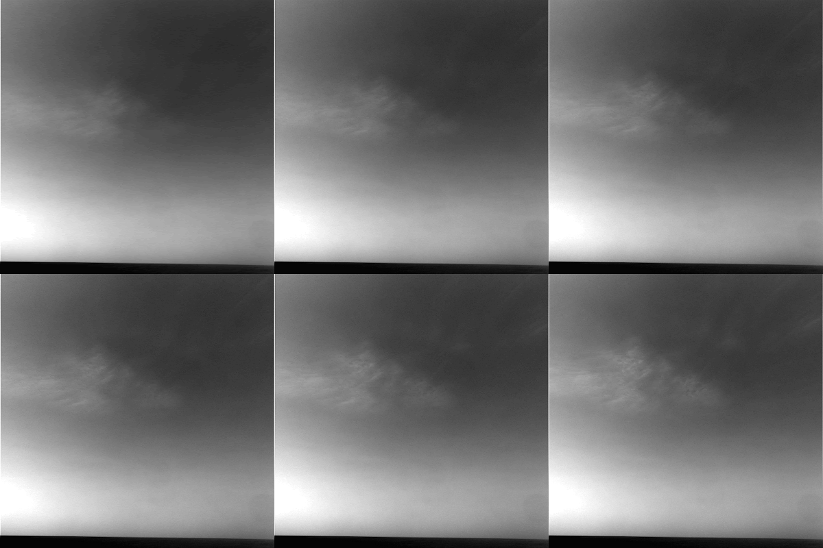
Clouds that are probably composed of ice crystals and possibly supercooled water droplets were caught in images by NASA’s Opportunity rover

Credit: NASA/JPL/Texas A&M/Cornell

Curiosity celebrated two years on Mars on August 5, 2014, and is continuing its progress across the surface of the planet.

The rover has already fulfilled one of its primary mission goals by confirming that environments theoretically capable of supporting microbial life were once present on ancient Mars.

Now Curiosity is continuing its journey toward the slopes of Mount Sharp and is currently headed for an outcrop dubbed 'Pahrump Hills.

In a tweet on September 2, 2014, Curiosity shared its view of the path ahead and proclaimed:

"Head for the hills! I'm driving towards these hills on Mars to do geology work & also search for clouds."

Curiosity is described as the first roving analytical laboratory on Mars, and has been cruising around the planet these past two years drilling rocks, zapping soil, and photographing layered outcrops.

The geological data that the mission has returned has been invaluable for astrobiologists trying to interpret Mars' past climate conditions but why is Curiosity also taking time to turn its instruments skyward?

Astrobiology Magazine spoke with Dr. Robert M. Haberle, Planetary Scientist at NASA Ames and a team member for the Rover Environmental Monitoring Station (REMS), and asked him why astrobiologists are curious about martian clouds.

"Clouds are part of the planet's climate system," explained Haberle. "Their behaviour tells us about winds and temperatures."

Studying weather and clouds on Mars today can shed light on processes that have shaped the planet's climate through time.

Bob M. Haberle
"Some studies suggest that clouds in the past may have significantly warmed the planet through a greenhouse effect. A warmer environment is more conducive to life," said Haberle.

Clouds are also connected to wind and weather patterns, and studying weather is important for interpreting how natural processes have shaped the rocks, dunes and outcrops that Curiosity has been photographing.

Haberle points out that, "winds are the primary mechanism for shaping the planet's surface for the past 3-4 billion years.

Studying martian weather can not only help us understand Mars' current climate, but also provides clues about its past environment and the physical processes that operate on the planet.

This information can in turn help astrobiologists interpret the planet's geological record.

REMS is an environmental monitoring station composed of six different sensors.

The instrument collects daily and seasonal data on wind, pressure, relative humidity, temperature and ultraviolet radiation at the martian surface.

REMS was contributed to the Mars Science Laboratory (MSL) mission by the the Centro de Astrobiologia (CAB) in Spain.

Tuesday, August 5, 2014

NASA ER-2: Melt ponds shine in MABEL laser altimeter flight images

Engineers installed a new camera system on MABEL for its summer 2014 campaign, so scientists could better understand what it measured during flights. 

A key goal of the Alaska-based campaign was to measure glacial melt ponds like this one, photographed July 16. 

Credit: NASA

Even from 65,000 feet above Earth, aquamarine melt ponds in the Arctic stand out against the white sea ice and ice sheets. These ponds form every summer, as snow that built up on the ice melts, creating crystal clear pools.

On July 16 and July 17, NASA's ER-2 aircraft flew above Alaskan glaciers and to the North Pole, carrying an instrument called the Multiple Altimeter Beam Experimental Lidar (MABEL).

MABEL is a laser altimeter, measuring the elevation of glaciers, mountains, forests and other topography below.

Scientists will use those measurements to design analysis software, or algorithms, for the upcoming Ice, Cloud and land Elevation Satellite-2 (ICESat-2) mission.

The 2014 MABEL campaign continued through July and was launched, in part, to capture melt ponds and other features of summer ice.

After nine science flights out of Fairbanks, Alaska, the ER-2 and MABEL returned to California on Aug. 1, gathering additional data along the way.

For this campaign, engineers added a new camera system to allow the team to match the MABEL measurements with a visual glimpse of the ground.

The digital camera takes a picture every 3 seconds, each frame capturing an area about 2.5 by 1.5 kilometers (1.6 by 0.9 miles).

Some of these first images downloaded were just what the MABEL team wanted to see, said Thorsten Markus, ICESat-2 project scientist at NASA's Goddard Space Flight Center in Greenbelt, Maryland.

They want to understand how the MABEL data collected over a melt pond differs from data collected over open water, ice and more, and the images indicate there will be good measurements to analyze.

From the ER-2’s cruising altitude of 65,000 feet, the camera system snaps images of an area about 2.5 by 1.5 kilometers (1.6 by 0.9 miles). 

These melt ponds, formed by snowmelt on Alaskan glaciers, can range in size and shape. 

Credit: NASA

"We have clear open water, then we see melt ponds and then we see open water again," Markus said of a shot taken on the way to the North Pole.

"For algorithm development, this is perfect."

On a July 17 flight to the North Pole and back, the ER-2 aircraft carrying the MABEL instrument flew over fractured sea ice, dotted with melt ponds and marked by ridges formed by the dynamic ice. 

Credit: NASA

Wednesday, June 4, 2014

Alien Planet-Hunting Telescope Tool SPHERE Snaps 1st Amazing Images - Video


A new instrument designed to give scientists a direct look at nearby alien worlds has seen its "first light" in Chile, astronomers announced today (June 4).

This infrared image shows the dust ring around the nearby star HR 4796A in the southern constellation of Centaurus. 

Credit: ESO/J.-L. Beuzit et al./SPHERE Consortium

Spectro-Polarimetric High-contrast Exoplanet REsearch (SPHERE), the new alien planet detection tool was mounted on the European Southern Observatory's Very Large Telescope Unit Telescope 3 in the Atacama Desert last month.

In its first few days of operations, SPHERE already has produced images of Saturn's moon Titan and dust discs around stars as it gears up to take pictures of exoplanets, ESO officials said.

Using space and ground-based telescopes, astronomers have detected more than 2,000 exoplanets since spotting the first ones back in the 1990s but scientists have rarely been able to look at these worlds directly because the weak glow of a planet is often outshined by bright light from its parent star.

Instead, astronomers often use indirect techniques like the transit method, in which they look for telltale dips in a star's brightness caused when a planet crosses in front of the star.


To be observed directly, planets usually need to be very large and very far away from their parent star.

The first confirmed direct photo of an alien planet in 2010 showed a world eight times the mass of Jupiter that orbited its host star at from more than 300 times the distance between Earth and the sun.

The SPHERE instrument is shown shortly after it was installed on ESO’s VLT Unit Telescope 3 

Credit: ESO/J. Girard

SPHERE is designed to get the highest contrast possible in a small patch of sky around a star to see exoplanets that might otherwise be hidden.

To boost the contrast in its images, SPHERE uses adaptive optics to correct for the blurring effects of the Earth's atmosphere as well as a coronagraph also blocks out starlight.

Sunday, April 27, 2014

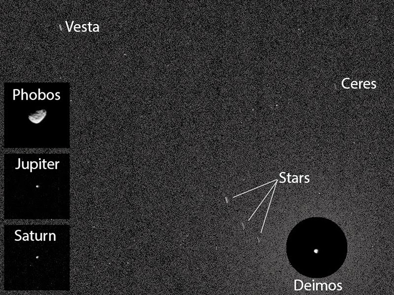
NASA's Curiosity rover captures images of asteroids Ceres and Vesta

For the first time, NASA's Curiosity rover has captured images of an asteroid from the surface of Mars -- two of them, in fact.

The imagery recorded by Curiosity and beamed back to Earth feature Ceres and Vesta, two of the largest asteroids in the asteroid belt that runs between between Mars and Jupiter.

This Curiosity first was also a bit of a coincidence, as the SUV-sized rover had aimed its cameras at the Martian sky in order to snap shots of the Red Planet's two moons, not hunt for asteroids whizzing by.

"This imaging was part of an experiment checking the opacity of the atmosphere at night in Curiosity's location on Mars, where water-ice clouds and hazes develop during this season," camera team member Mark Lemmon, of Texas A&M University, explained in a statement.

"The two Martian moons were the main targets that night, but we chose a time when one of the moons was near Ceres and Vesta in the sky."

Mark Lemmon
NASA is currently on its way to get an even closer look at this two giant space rocks.

NASA's Dawn spacecraft orbited the 350-mile-wide Vesta asteroid in 2011 and 2012, and it is preparing to orbit the 590-mile-wide Ceres in 2015.

Thursday, April 17, 2014

ESA Sentinel 1A: First radar vision for Copernicus

Brussels from Sentinel-1A. Credit: ESA

Launched on 3 April, ESA's Sentinel-1A satellite has already delivered its first radar images of Earth.

They offer a tantalising glimpse of the kind of operational imagery that this new mission will provide for Europe's ambitious Copernicus environmental monitoring programme.

Rather aptly, the first image shows Brussels in Belgium, the seat of the European Commission.

The European Commission leads the Copernicus programme and coordinates the broad range of services to improve the management of the environment and to safeguard everyday lives.

ESA is responsible for developing the family of Sentinel satellites and for ensuring that the stream of data are available for these services.

This first image of Belgium was captured on 12 April, just one day after the satellite was put into its operational attitude, and demonstrates the potential of Sentinel-1A's radar vision.

Since it was launched from Europe's Spaceport in French Guiana, Sentinel-1A has undertaken a complicated routine to deploy its 12-m long radar and two 10-m long solar wings, as well as passing a series of initial instrument checks.

The satellite is not yet in its operational orbit, nor is it calibrated for supplying true data. These tasks will be carried out during the commissioning phase, which will take about three months to complete.

This preliminary set of images simply offer a taster of what's to come.

One of the images acquired on the same day focuses on Pine Island Glacier in Antarctica. 

This glacier is in a state of 'irreversible retreat' so it is important to keep a very close eye on glaciers such as these as they lose ice to the ocean.

Another shows a transect over the northern part of the Antarctica Peninsula.

As well as monitoring glaciers, Sentinel-1A is poised to generate timely maps of sea-ice conditions, particularly for the increasingly busy Arctic waters.

Images from its advanced radar can be used to distinguish clearly between the thinner more navigable first-year ice and the hazardous, much thicker multiyear ice to help assure safe year-round navigation in polar waters.

As these first images show, Sentinel-1A is already demonstrating the vital role it will play in the largest civil Earth observation programme ever conceived.

Friday, February 14, 2014

NASA LADEE transmits its first images of the Moon

Series of LADEE star tracker images features the lunar terrain. Credit: NASA Ames

Earlier this month, NASA's Lunar Atmosphere and Dust Environment Explorer (LADEE) observatory successfully downlinked images of the moon and stars taken by onboard camera systems, known as star trackers.

This is the first time the LADEE team commanded the spacecraft to send these pictures back to Earth.

The main job of a star tracker is to snap images of the surrounding star field so that the spacecraft can internally calculate its orientation in space.

It completes this task many times per minute. The accuracy of each of LADEE's instruments' measurements depends on the star tracker calculating the precise orientation of the spacecraft.

Butler Hine
"Star tracker cameras are actually not very good at taking ordinary images," said Butler Hine LADEE project manager at NASA's Ames Research Center in Moffett Field, Calif.

"But they can sometimes provide exciting glimpses of the lunar terrain."

Given the critical nature of its assignment, a star tracker doesn't use ordinary cameras.

Star trackers' lenses have a wide-angle field of view to capture the night sky in a single frame.

The images shown here were acquired on Feb. 8, 2014, around 23:45 UTC, while LADEE was carrying out atmospheric measurements.

The series of five images were taken at one-minute intervals, and caught features in the northern western hemisphere of the moon.

LADEE was traveling approximately 60 miles (100 km) per minute along its orbit.

All images were taken during lunar night, but with Earthshine illuminating the surface.

The initial image captured the smooth-floored crater Krieger, about 14 miles (23 km) in diameter, on the horizon, with four mile (seven km) wide Toscanelli, in the foreground.

The second image shows Wollaston P, about two-and-a-half miles (4 km) diameter, near the horizon, and the southeastern flank of the lunar mountain Mons Herodotus.

The third image caught a minor lunar mountain range, Montes Agricola, which is northwest of the large bright crater Aristarchus (out of view), as well as the flat-floored crater Raman, about six miles (10 km) diameter.

Image four in the series captures Golgi, about four miles (6 km) in diameter, and three-mile-wide (5 km) Zinner.

The final image views craters Lichtenberg A and Schiaparelli E in the smooth mare basalt plains of Western Oceanus Procellarum, west of the Aristarchus plateau.

The star trackers will operate while LADEE continues to measure the chemical composition of the atmosphere, collect and analyze samples of lunar dust particles in the atmosphere and hope to address a long-standing question: Was lunar dust, electrically charged by sunlight, responsible for the pre-sunrise glow above the lunar horizon observed during several Apollo missions? And who knows?

The LADEE star trackers may help answer that question.

Thursday, January 30, 2014

DigitalGlobe IKONOS-2 Images: Sochi Winter Olympics Sites From Space

This DigitalGlobe satellite image shows the 2014 Winter Olympics village in Sochi, Russia

Image Credit: DigitalGlobe

Here's a view of the Olympics only the astronauts can get.

New satellite imagery shows the sprawling sporting venues and slopes that will host the world's best athletes next week when the 2014 Winter Olympic Games in Sochi, Russia begin.

The recent photos come from DigitalGlobe, a commercial company based in Colorado that provides high-resolution images of the planet, using a variety of satellites, including IKONOS-2.


Ikonos-2 is an imaging satellite of GeoEye (formerly Space Imaging Inc., before the acquisition by ORBIMAGE) providing high-resolution imagery on a commercial basis. 

With Ikonos-2, a new era of 1m spatial resolution imagery began for spaceborne instruments in the field of civil Earth observation. 

The Ikonos satellite system was built by LMMS (Lockheed Martin Missiles & Space) of Sunnyvale, CA (USA).

Image Credit: ESA

This DigitalGlobe satellite image shows the 2014 Winter Olympics event slopes in Sochi, Russia

Both these images were collected Jan. 2, 2014. 

Image Credit: DigitalGlobe

Wednesday, January 29, 2014

Satellite images detect underwater volcanic eruptions

Degassing lava erupts onto the seafloor at NW Rota-1 volcano, creating a billowing cloudy plume that is extremely acidic, and is full of carbon dioxide and sulfur. 

Credit: Woods Hole Oceanographic Institution (WHOI)

Oregon State University scientists have discovered how to pinpoint the time and place of underwater volcanic eruptions using satellite images.

Volcanic eruptions on the ocean floor can spew large amounts of pumice and fine particles, as well as hot water that brings nutrients to the surface, resulting in plumes of algae.

The plumes are picked up as shades of green in satellite images.

Robert O'Malley
"Some volcanic eruptions take place hundreds of feet below water and show no changes to the sea surface to the naked eye," said Robert O'Malley, an OSU research assistant in botany and plant pathology in OSU's College of Agricultural Sciences.

"It's amazing an orbiting satellite can detect color changes that indicate an eruption has taken place. Many times you can't spot an eruption if you were floating over it in a boat."

Underwater volcanic eruptions are rarely detected, so little is known about them, according to Mike Behrenfeld, an OSU expert in marine algae and and one of the researchers on the project.

"Satellite measurements of the planet are made every day," Behrenfeld said, "so this new method provides another tool for spotting these dramatic events that affect life in the oceans."

O'Malley and Behrenfeld developed a process for analyzing low-resolution images to show evidence of eruptions, which can extend over thousands of square miles, by matching five known eruptions with data from NASA satellites.

"We measured sunlight going into the ocean interacting with particles consistent with underwater volcanic eruptions," said O'Malley.

"From there, we found we could connect color data with documented eruptions. Now we have a better idea of what to look for in the data when we don't know about the eruption first."

Next, the researchers plan to test how well their method works as eruptions are happening. Further study will also focus on the depth at which eruptions can be detected.

The study was published in the journal Remote Sensing of the Environment.

More information: Read the study here: ir.library.oregonstate.edu/xmlui/handle/1957/45229

Thursday, January 9, 2014

StSci Team: 3D Printed Hubble Images for Blind Astronomers


Astronomers at the Space Telescope Science Institute (StSci) are experimenting with 3D printers to deliver Hubble imagery to the vision impaired. It is also useful as a learning tool for sighted people.

Credit: Space Telescope Science Institute

Monday, December 9, 2013

NASA IRIS: Providing unprecedented images of Sun

The fine detail in images of prominences in the sun's atmosphere from NASA's Interface Region Imaging Spectrometer (IRIS) -- such as the red swirls shown here -- are challenging the way scientists understand such events. 

Credit: NASA/LMSAL /IRIS

The region located between the surface of the sun and its atmosphere has been revealed as a more violent place than previously understood, according to images and data from NASA's newest solar observatory, the Interface Region Imaging Spectrograph, (IRIS).

Solar observatories look at the sun in layers. By capturing light emitted by atoms of different temperatures, they can focus in on different heights above the sun's surface extending well out into the solar atmosphere, the corona.

On June 27, 2013, IRIS, was launched, to study what's known as the interface region – a layer between the sun's surface and corona that previously was not well observed.

Over its first six moths, IRIS has thrilled scientists with detailed images of the interface region, finding even more turbulence and complexity than expected.

IRIS scientists presented the mission's early observations at a press conference at the Fall American Geophysical Union meeting on Dec. 9, 2013.

Alan Title
"The quality of images and spectra we are receiving from IRIS is amazing," said Alan Title, IRIS principal investigator at Lockheed Martin in Palo Alto, Calif. "And we're getting this kind of quality from a smaller, less expensive mission, which took only 44 months to build."

For the first time, IRIS is making it possible to study the explosive phenomena in the interface region in sufficient detail to determine their role in heating the outer solar atmosphere.

The mission's observations also open a new window into the dynamics of the low solar atmosphere that play a pivotal role in accelerating the solar wind and driving solar eruptive events.

Tracking the complex processes in the interface region requires instrument and modeling capabilities that are only now within our technological reach.

IRIS captures both images and what's known as spectra, which display how much of any given wavelength of light is present.

This, in turn, corresponds to how much material in the solar atmosphere is present at specific velocities, temperatures and densities.

IRIS's success is due not only to its high spatial and temporal resolution, but also because of parallel development of advanced computer models.

The combined images and spectra have provided new imagery of a region that was always known to be dynamic, but shows it to be even more violent and turbulent than imagined.

This is an artist's concept of the Interface Region Imaging Spectrograph, or IRIS, satellite in orbit. Credit: NASA

"We are seeing rich and unprecedented images of violent events in which gases are accelerated to very high velocities while being rapidly heated to hundreds of thousands of degrees," said Bart De Pontieu, the IRIS science lead at Lockheed Martin.

"These types of observations present significant challenges to current theoretical models."


This video compares the Solar Dynamics Observatory's (SDO) resolution with the Interface Region Imaging Spectrograph (IRIS) resolution for the same region of the Sun