Showing posts with label Mars. Show all posts

Monday, February 9, 2015

ESA Mars Express Image: Cappuccino swirls at Mars’ south pole

Swirls of chocolate, caramel and cream, this image is definitely one to trigger sweet-toothed cravings.

Smooth cream-coloured plateaus surrounded by cocoa-dusted ridges interspersed with caramel-hued streaks create a scene reminiscent of a cosmic cappuccino.

This picture is, perhaps surprisingly, from ESA’s Mars Express, which has been exploring and imaging the martian surface and atmosphere since 2003.

We may be used to seeing numerous images of red and brown-hued soil and ruddy landscapes peppered with craters, but the Red Planet isn’t always so red.

The bright white region of this image shows the icy cap that covers Mars’ south pole, composed of frozen water and carbon dioxide.

While it looks smooth in this image, at close quarters the cap is a layered mix of peaks, troughs and flat plains, and has been likened in appearance to swiss cheese.

The southern cap reaches some 3 km thick in places, and is around 350 km in diameter. This icy region is permanent; in the martian winter another, thinner ice cap forms over the top of it, stretching further out across the planet and disappearing again when the weather warms up.

The cap is around 150 km north of Mars’ geographical south pole and Mars Express has shed light on why this ice cap is displaced.

Perspective view of Hellespontus Montes

Credit: ESA

Deep impact craters,notably the Hellas Basin, the largest impact structure on the entire planet at 7 km deep and 2300 km across, funnel the strong winds that blow across Mars towards its southern pole, creating a mix of different low- and high-pressure systems.

The carbon dioxide in the polar cap sublimates at different rates in these regions with contrasting pressure, resulting in the cap’s lopsided structure.

Mars Express imaged this area of Mars on 17 December 2012, in infrared, green and blue light, using its High Resolution Stereo Camera.

This image was processed by Bill Dunford, using data available from the ESA Planetary Science Archive.

Wednesday, January 28, 2015

MARS Habitation Fire ends GreenHab mission

Mars Desert Research Station (MDRS) GreenHab following a fire on Dec. 29, 201

Credit: Nick Orenstein

Four crewmembers simulating a mission on Mars dealt with a real-life emergency late last month, a greenhouse fire so strong that flames reached at least 10 feet (3 meters) high.

On Dec. 29, the first day of their mission, the crew noticed an unusual power surge in their habitat at the Mars Desert Research Station (MDRS), in the Utah desert near the small town of Hanksville.

A few minutes later, somebody spotted smoke coming from the greenhouse.

Crew commander Nick Orenstein, an experienced camper who has built bonfires in the past, ran outside to take a look.

He said he figured the group could take on the fire, because the smoke was blowing away from the habitat, and only one shelf inside the greenhouse was aflame.

At that time, the fire was about the size of three overstuffed chairs.

"This is a moment where instinct took over, the instinct of fight or flight, and we had fight," Orenstein told reporters. "There really wasn't a question at the moment."

It took the crew about half an hour to bring the fire under control.

Orenstein and crew engineer Dmitry Smirnov used all available fire extinguishers on site, but even after the extinguishers were exhausted and the power cut, the fire was still not out.

"We put out the rest by putting water on the flames," Orenstein recalled.

The four-person crew was barely able to deal with the emergency, he added.

"Six or seven [people], to me, seems realistic as the adequate number of people to handle a situation like this most effectively."

The middle of the greenhouse, which was called the GreenHab, was destroyed. An investigation by the fire marshal determined two days later that an electrical heater caused the fire, which was ruled an accident.

The heater was set up close to some wooden shelves that had likely dried out over more than 10 years of use, said Orenstein, who is also the volunteer MDRS GreenHab coordinator.

Damage inside the Mars Desert Research Station GreenHab following a fire on Dec. 29, 2014. 

Credit: Nick Orenstein

In response to a 911 call, the Lane County sheriff came to MDRS later on Dec. 29, after the crew had successfully fought the fire.

NB: The isolated location of the facility means it usually takes some time for emergency services to arrive.

The sheriff did a preliminary investigation and confirmed that nobody was hurt, Orenstein said.

Orenstein's crew, the 146th one to use the habitat, decided it was best to stay in Hanksville temporarily, for two reasons, there were no fire extinguishers left at the research station, and there was some concern about chemical contamination in the habitat from the fire.

"My responsibilities for the next few days were to look after the crew and to make sure that they were OK," Orenstein said.

"Essentially, it was a post-tramautic stress therapy session there. We were making sure we were all OK, and looking out for each other."

MDRS director Shannon Rupert and a few other MDRS officials did extra cleanup before the next crew arrived, and Orenstein went back to the facility briefly for the Crew 147 handover later in January.

A temporary tentlike greenhouse is now available for experiments to go forward this season, Rupert added.

"It's devastating because it's a loss of a functional component of the campus," Rupert told reporters.

"But it could have been so much worse. Everyone was safe. That was the main thing. Everybody got out."

Friday, January 16, 2015

UK Space Agency justify loss of Beagle 2 on Mars - Video

UK Space Agency continue to justify expenditure and efforts to launch Beagle 2 lander.

Grainy images picked up by NASA MRO HiRise camera scanning Mars.

UK Space Agency Announce discovery of Beagle-2 on Mars

Following a lengthy and protracted briefing by the UK Space Agency, they finally acknowledged the discovery of the Beagle 2 on Mars by the HiRise camera on MRO.
The UK Agency seemed to feel the need to promote their apparent expertise and kudos before breaking the news before showing off the grainy images.


This is one of the images shown at the briefing. It is far from clear but we are assured it contains the component parts of the UK's failed Beagle 2.
More than 11 years after UK Mars probe Beagle 2 was lost, believed crashed, space scientists are set to reveal new findings about what hapened to the spacecraft.

Mystery surrounds exactly what will be disclosed by experts from the European Space Agency and the underfunded, struggling, UK Space Agency at the English National Academy of Science, known as the Royal Society in London on Friday, but it has raised hopes that orbiting spacecraft around Mars might have located the debris of the Beagle 2.

The probe was the brainchild of the eccentric, mutton-chopped Professor Colin Pillinger, of the UK’s Open University, who died suddenly in May 2014 from a brain haemorrhage.

Beagle 2 was carried to Mars by ESA’s Mars Express which remains in orbit to this day performing valuable surveys of the planet.

Beagle was due to land on Christmas Day 2003, but nothing was ever heard from the tiny craft.

Experts later concluded that its parachute had failed in the extra thin atmosphere and it hit the ground too hard.

Months later, Colin called an impromptu press conference, convinced that he had identified a speck in a photo of the martian surface as his lost probe, but later higher-resolution imagery from a NASA orbiter showed there was nothing.

This recent announcement would indicate that this time there is hope that something really has been spotted.

The panel at Friday’s announcement will include Beagle 2’s mission manager Professor Mark Sims, Dr John Bridges of Leicester University’s Space Research Centre, the European Space Agency’s director of science and robotic exploration Alvaro Giménez, and David Parker, of Durham University and the underfunded UK Space Agency.

A recent image from the HiRise camera on the NASA MRO. 

Credit: NASA, JPL, University of Arizona

All are remaining tight-lipped about what will be revealed, but interestingly, Dr Bridges is a member of the team working with the HiRISE camera aboard NASA's Mars Reconnaissance Orbiter, which is the only imager powerful enough to pick out the debris of Beagle 2, or any other probe, from orbit.

John Zarnecki, Emeritus Professor of Space Science, and Professor Pillinger’s former colleague, told reporters: “I don’t know what they will announce. All one can think of is that they might have got an image of the probe, but if Beagle 2 is in a thousand pieces, it is unlikely that we will have found the pieces.”

“When dear old Colin was alive, he imagined he could see the Beagle 2 in single pixels. None of us could see it, he was the only one who could. So if they really have found it this time, it would be wonderful.”

Professor Zarnecki, who headed the OU’s Planetary and Space Sciences department, said that finding Beagle 2 would be an important event, but there was no chance that it could still work.

He said: “The probe will be dead. There could be no battery life and it would have frozen probably. Electronic materials and components don’t like the cold of Mars very much.”

“The main thing is that it could tell us something about how and why it failed. We’re not going to get anything scientific out of it now, but anything we can learn about how and why it failed informs our designs for the future.

“One of the reasons why space missions on the whole are so successful is that we do learn from experience. It is similar to why flying by plane is so safe - we learn from failures.”

Professor Zarnecki had his own experiment on Beagle 2, a tiny device to measure temperature, air pressure, and wind-speed and direction, “like a weather station, but a fancy one”, he said.

Tuesday, January 13, 2015

MRO Mars HiRise Image: Russell Crater Dunes

Russell Crater Dunes on Mars

Credit: HiRise camera Team, JPL, University of Arizona

The Russell Crater dune field is covered seasonally by carbon dioxide frost, and this image shows the dune field after the frost has sublimated (evaporated directly from solid to gas).

There are just a few patches left of the bright seasonal frost.

Numerous dark dust devil tracks can be seen meandering across the dunes. The face of the largest dune is lined with gullies.

The source of the gullies is unclear but could involve erosion by the seasonal carbon dioxide ice.

A closer view of the Russell Crater Dunes on Mars, in colour.

Credit: HiRise camera Team, JPL, University of Arizona

Thursday, January 8, 2015

NASA Mars Opportunity Rover: Perched atop Martian hill, Cape Tribulation

NASA's Opportunity rover is soaking in the view from its perch atop a Martian hill as engineers continue to fix a problem with its computer memory.

The aging rover beamed new images to Earth on Wednesday, confirming it reached the hill informally called Cape Tribulation.

Opportunity landed on Mars more than a decade ago and has recently suffered bouts of amnesia stemming from an issue with its flash memory.

The six-wheel rover has been able to drive despite the occasional memory lapse.

Opportunity will spend several days at the summit snapping pictures that engineers will stitch into a colour panorama.

Project manager John Callas says the rover will try to find interesting rocks to study. If there are none to be found, it will keep driving.

Opportunity rover takes in view from top of Martian hill


These images sent by NASA's Opportunity rover on Wednesday, Jan. 7, 2015 shows a view from atop a Martian hill. 

Opportunity will spend several days at the summit making pictures that engineers will stitch into a color panorama. (AP Photo/NASA)

Tuesday, January 6, 2015

NASA Mars Curiosity Rover: Potential signs of ancient life in Mars rover photos

A rock bed at the Gillespie Lake outcrop on Mars displays potential signs of ancient microbial sedimentary structures. 

Credit: NASA

A careful study of images taken by the NASA rover Curiosity has revealed intriguing similarities between ancient sedimentary rocks on Mars and structures shaped by microbes on Earth.

The findings suggest, but do not prove, that life may have existed earlier on the Red Planet.

The photos were taken as Curiosity drove through the Gillespie Lake outcrop in Yellowknife Bay, a dry lakebed that underwent seasonal flooding billions of years ago.

Mars and Earth shared a similar early history. The Red Planet was a much warmer and wetter world back then.

On Earth, carpet-like colonies of microbes trap and rearrange sediments in shallow bodies of water such as lakes and costal areas, forming distinctive features that fossilize over time.

These structures, known as microbially-induced sedimentary structures (or MISS), are found in shallow water settings all over the world and in ancient rocks spanning Earth's history.

Nora Noffke, a geobiologist at Old Dominion University in Virginia, has spent the past 20 years studying these microbial structures.

Last year, she reported the discovery of MISS that are 3.48 billion years old in the Western Australia's Dresser Formation, making them potentially the oldest signs of life on Earth.

In a paper published online last month in the journal Astrobiology (the print version comes out this week), Noffke details the striking morphological similarities between Martian sedimentary structures in the Gillespie Lake outcrop (which is at most 3.7 billion years old) and microbial structures on Earth.

The distinctive shapes include erosional remnants, pockets, domes, roll-ups, pits, chips and cracks, which on Earth can extend from a few centimeters to many kilometers.

Although Noffke makes a tantalizing case for possible signs of ancient life on Mars, her report is not a definitive proof that these structures were shaped by biology.

Getting such confirmation would involve returning rock samples to Earth and conducting additional microscopic analyses, a mission that isn't scheduled anytime in the near future.

"All I can say is, here's my hypothesis and here's all the evidence that I have," Noffke says, "although I do think that this evidence is a lot."

"The fact that she pointed out these structures is a great contribution to the field," says Penelope Boston, a geomicrobiologist at the New Mexico Institute of Mining and Technology.

"Along with the recent reports of methane and organics on Mars, her findings add an intriguing piece to the puzzle of a possible history for life on our neighboring planet."

A Careful Analysis
"I've seen many papers that say 'Look, here's a pile of dirt on Mars, and here's a pile of dirt on Earth,'" says Chris McKay, a planetary scientist at NASA's Ames Research Center and an associate editor of the journal Astrobiology. "And because they look the same, the same mechanism must have made each pile on the two planets.'"

McKay adds: "That's an easy argument to make, and it's typically not very convincing. However, Noffke's paper is the most carefully done analysis of the sort that I've seen, which is why it's the first of its kind published in Astrobiology."

Overlay of sketch on photograph from above to assist in the identification of the structures on the rock bed surface. 

Image credit: Noffke (2105). Credit: ASTROBIOLOGY, published by Mary Ann Liebert, Inc.

The images on which Noffke drew are publicly available on the Mars Science Laboratory page on NASA's website.

"In one image, I saw something that looked very familiar," Noffke recalls. "So I took a closer look, meaning I spent several weeks investigating certain images centimeter by centimeter, drawing sketches, and comparing them to data from terrestrial structures, and I've worked on these for 20 years, so I knew what to look for."

Noffke compared the rover pictures to images taken at several sites on Earth, including modern sediment surfaces in Mellum Island, Germany; Portsmouth Island, USA; and Carbla Point, Western Australia; as well as older fossils of microbial mats in Bahar Alouane, Tunisia; the Pongola Supergroup in Africa; and the Dresser Formation in Western Australia.

The photos showed striking morphological similarities between the terrestrial and Martian sedimentary structures.

The distribution patterns of the microbial structures on Earth vary depending on where they are found. Different types of structures are found together in different types of environments.

For instance, microbial mats that grow in rivers will create a different set of associations than those that grow in seasonally flooded environments.

The patterns found in the Gillespie Lake outcrop are consistent with the microbial structures found in similar environments on Earth.

What's more, the terrestrial structures change in a specific way over time. As the microbial mats form, grow, dry up, crack and re-grow, specific structures become associated with them.

Here again, Noffke found that the distribution pattern in Martian rocks correspond with microbial structures on Earth that have changed over time. Taken together, these clues strengthen her argument beyond simply pointing out the similarities in shape.

In her paper, she also describes alternative processes through which these could have formed. For instance, the chips, pits and cracks could be the product of erosion by salt, water, or wind.

"But if the Martian structures aren't of biological origin," Noffke says, "then the similarities in morphology, but also in distribution patterns with regards to MISS on Earth would be an extraordinary coincidence."


Potential MISS erosional remnant on Mars (top); edge of a microbial mat–overgrown erosional remnant on Portsmouth Island, USA (middle); erosional remnant of a modern MISS on Mellum Island, Germany (bottom). 

Credit: Mars: NASA; Earth: Nora Noffke

"At this point, all I'd like to do is point out these similarities," she adds. "Further evidence must be provided to verify this hypothesis."

More information: The paper is available online: online.liebertpub.com/doi/pdf/… 0.1089/ast.2014.1218

Saturday, December 20, 2014

ESA Mars Express: Flying over Becquerel Crater - Video


This latest release from the camera on ESA’s Mars Express is a simulated flight over the Becquerel crater, showing large-scale deposits of sedimentary material.

Becquerel crater is 167 km in diameter and lies in the Arabia Terra region on Mars, on the boundary between the southern highlands and northern lowlands.

This movie shows the location of Becquerel crater on Mars and then provides a flyover of a mound of layered, sulphate-bearing deposits on the crater floor, thought to have formed under the influence of water.

The darker material surrounding the mound is wind-blown dust from a source to the north, and provides evidence for effects of wind in eroding the sedimentary deposits.

The movie was made from a mosaic of four individual images acquired by the High Resolution Stereo Camera on ESA’s Mars Express during orbits 3253/1, 5332, 5350 and 5368.

The image is centred at about 22ºN / 352ºE. The average ground resolution is about 17 m per pixel.

NASA's Curiosity Mars Rover: Organics Possibly Present

This image illustrates possible ways methane might be added to Mars' atmosphere (sources) and removed from the atmosphere (sinks). 

NASA's Curiosity Mars rover has detected fluctuations in methane concentration in the atmosphere, implying both types of activity occur on modern Mars. 

Credit: NASA/JPL-Caltech/SAM-GSFC/Univ. of Michigan

NASA's Curiosity Mars rover has measured a tenfold spike in methane, an organic chemical, in the atmosphere around it and detected other organic molecules in a rock-powder sample collected by the robotic laboratory's drill.

"This temporary increase in methane, sharply up and then back down, tells us there must be some relatively localized source," said Sushil Atreya of the University of Michigan, Ann Arbor, and Curiosity rover science team.

"There are many possible sources, biological or non-biological, such as interaction of water and rock."

Researchers used Curiosity's onboard Sample Analysis at Mars (SAM) laboratory a dozen times in a 20-month period to sniff methane in the atmosphere.

During two of those months, in late 2013 and early 2014, four measurements averaged seven parts per billion.

Before and after that, readings averaged only one-tenth that level.

Curiosity also detected different Martian organic chemicals in powder drilled from a rock dubbed 'Cumberland', the first definitive detection of organics in surface materials of Mars.

These Martian organics could either have formed on Mars or been delivered to Mars by meteorites.

Organic molecules, which contain carbon and usually hydrogen, are chemical building blocks of life, although they can exist without the presence of life.

Curiosity's findings from analyzing samples of atmosphere and rock powder do not reveal whether Mars has ever harboured living microbes, but the findings do shed light on a chemically active modern Mars and on favorable conditions for life on ancient Mars.

"We will keep working on the puzzles these findings present," said John Grotzinger, Curiosity project scientist of the California Institute of Technology in Pasadena (Caltech).

"Can we learn more about the active chemistry causing such fluctuations in the amount of methane in the atmosphere? Can we choose rock targets where identifiable organics have been preserved?"

Researchers worked many months to determine whether any of the organic material detected in the Cumberland sample was truly Martian.

Curiosity's SAM lab detected in several samples some organic carbon compounds that were, in fact, transported from Earth inside the rover.

However, extensive testing and analysis yielded confidence in the detection of Martian organics.

Wednesday, December 17, 2014

MARS HiRise Map: Signs of Ancient Mars Lakes and Quakes

Long ago, in the largest canyon system in our solar system, vibrations from "marsquakes" shook soft sediments that had accumulated in Martian lakes.

The shaken sediments formed features that now appear as a series of low hills apparent in a geological map based on NASA images.

The map was released by the U.S. Geological Survey (USGS).

This map of the western Candor Chasma canyon within Mars' Valles Marineris is the highest-resolution Martian geological map ever relased by USGS.

It is derived from images taken by the High Resolution Imaging Science Experiment (HiRISE) camera on NASA's Mars Reconnaissance Orbiter (MRO), which reveal details smaller than a desk.

"This new map shows that at the time these sediments were deposited, a part of west Candor Chasma, specifically Condor Colles, contained numerous shallow, spring-fed lakes," said map author Chris Okubo of the USGS Astrogeology Science Center, Flagstaff, Arizona.


"These lakes helped to trap wind-blown sand and dust, which accumulated over time and formed the extensive sedimentary deposits we see today."

The wet sediments experienced seismic shaking in "marsquakes" related to movement along several large geological faults in the area. A series of low hills resulted.

Valles Marineris is more than 2,500 miles (4,000 kilometers) long. The conditions under which sedimentary deposits in it formed have been an open issue for decades.

Possibilities proposed have included accumulation in lakebeds, volcanic eruptions under glaciers within the canyons, and acculation of wind-blown sand and dust.

The map is available for download here. Additional information about the map is available here.

Tuesday, December 16, 2014

NASA Mars Opportunity Rover: Changes to non-Flash Memory usage

Persistent computer resets and "amnesia" events on NASA's Mars Exploration rover Opportunity that have occurred after reformatting the robot's flash memory have prompted a shift to a working mode that avoids use of the flash data-storage system.

The most recent reformatting of Opportunity's flash memory was last week.

Following that, performance of the flash memory remained intermittent, and difficulty in placing data into the memory led to computer resets during the weekend.

Flash memory retains information even when power is shut off during the rover's overnight power-conserving "sleep" time.

In the no-flash mode, the rover can continue normal operations of science observations and driving, though it cannot store data during the overnight sleep.

Data gathered each Martian day is stored in volatile memory, which on Opportunity is random-access memory (RAM). That data stored in volatile memory is relayed Earthward before sleep because it is lost when power goes off.

The team is developing a set of commands to restore usability of the flash memory through an overhaul more extensive than the reformatting that has been used so far.

The incidents of Opportunity's flash memory not accepting data for storage have occurred in only one of the seven banks of flash microchip circuitry on board. The team plans to send commands for the rover to avoid that entire bank.

"The mission can continue without storing data to flash memory, and instead store data in volatile RAM," said Mars Exploration Rover Project Manager John Callas of NASA's Jet Propulsion Laboratory, Pasadena, California.

"While we're operating Opportunity in that mode, we are also working on an approach to make the flash memory usable again."

"We will be sure to give this approach exhaustive reviews before implementing those changes on the rover."

Opportunity is examining outcrops on the western rim of Endeavour Crater while traversing southward toward "Marathon Valley," where clay minerals have been detected in observations by NASA's Mars Reconnaissance Orbiter.

Monday, December 15, 2014

NASA MAVEN: Links in Chain Leading to Atmospheric Loss Identified

NASA’s MAVEN mission is observing the upper atmosphere of Mars to help understand climate change on the planet. 

MAVEN entered its science phase on Nov. 16, 2014.

Image Credit: NASA's Goddard Space Flight Center

Early discoveries by NASA’s newest Mars orbiter are starting to reveal key features about the loss of the planet’s atmosphere to space over time.

The findings are among the first returns from NASA’s Mars Atmosphere and Volatile Evolution (MAVEN) mission, which entered its science phase on Nov. 16.

The observations reveal a new process by which the solar wind can penetrate deep into a planetary atmosphere.

They include the first comprehensive measurements of the composition of Mars’ upper atmosphere and electrically charged ionosphere.

The results also offer an unprecedented view of ions as they gain the energy that will lead to their to escape from the atmosphere.

“We are beginning to see the links in a chain that begins with solar-driven processes acting on gas in the upper atmosphere and leads to atmospheric loss,” said Bruce JakoskyMAVEN principal investigator with the Laboratory for Atmospheric and Space Physics at the University of Colorado, Boulder.

“Over the course of the full mission, we’ll be able to fill in this picture and really understand the processes by which the atmosphere changed over time.”

On each orbit around Mars, MAVEN dips into the ionosphere, the layer of ions and electrons extending from about 75 to 300 miles above the surface.

This layer serves as a kind of shield around the planet, deflecting the solar wind, an intense stream of hot, high-energy particles from the sun.

Scientists have long thought that measurements of the solar wind could be made only before these particles hit the invisible boundary of the ionosphere.

The SWIA instrument will measure the solar wind and ion density and velocity in the magnetosheath of Mars. 

Credit: UCB/SSL

MAVEN’s Solar Wind Ion Analyzer (SWIA), however, has discovered a stream of solar-wind particles that are not deflected but penetrate deep into Mars’ upper atmosphere and ionosphere.

Interactions in the upper atmosphere appear to transform this stream of ions into a neutral form that can penetrate to surprisingly low altitudes.

Deep in the ionosphere, the stream emerges, almost Houdini-like, in ion form again.

The reappearance of these ions, which retain characteristics of the pristine solar wind, provides a new way to track the properties of the solar wind and may make it easier to link drivers of atmospheric loss directly to activity in the upper atmosphere and ionosphere.

The NGIMS instrument will measure the composition and isotopes of thermal neutrals and ions in the Martian atmosphere. 

Credit: NASA/GSFC

MAVEN’s Neutral Gas and Ion Mass Spectrometer (NGIMS) is exploring the nature of the reservoir from which gases are escaping by conducting the first comprehensive analysis of the composition of the upper atmosphere and ionosphere.

These studies will help researchers make connections between the lower atmosphere, which controls climate, and the upper atmosphere, where the loss is occurring.

The instrument has measured the abundances of many gases in ion and neutral forms, revealing well-defined structure in the upper atmosphere and ionosphere, in contrast to the lower atmosphere, where gases are well-mixed.

The variations in these abundances over time will provide new insights into the physics and chemistry of this region and have already provided evidence of significant upper-atmospheric “weather” that has not been measured in detail before.

The STATIC instrument will enable measurement of energetic particles in the Martian atmosphere. Credit: NASA/SSL

New insight into how gases leave the atmosphere is being provided by the spacecraft’s Suprathermal and Thermal Ion Composition (STATIC) instrument.

Within hours after being turned on at Mars, STATIC detected the “polar plume” of ions escaping from Mars.

This measurement is important in determining the rate of atmospheric loss.

Wednesday, December 10, 2014

NASA Curiosity Rover: Water helped shape Mars

This evenly layered rock photographed by the Mast Camera (Mastcam) on NASA's Curiosity Mars Rover shows a pattern typical of a lake-floor sedimentary deposit not far from where flowing water entered a lake.

The scene combines multiple frames taken with Mastcam's right-eye camera on Aug. 7, 2014, during the 712th Martian day, or sol, of Curiosity's work on Mars.

It shows an outcrop at the edge of "Hidden Valley," seen from the valley floor.

This view spans about 5 feet (1.5 meters) across in the foreground.

An annotated image of MastCam on Curiosity rover.

Credit: NASA JPL

The colour has been approximately white-balanced to resemble how the scene would appear under daytime lighting conditions on Earth.

The image at the top of the page has a superimposed scale bar of 50 centimeters (about 20 inches).

This is an example of a thick-laminated, evenly-stratified rock type that forms stratigraphically beneath cross-bedded sandstones regarded as ancient river deposits.

These rocks are interpreted to record sedimentation in a lake, as part of or in front of a delta, where plumes of river sediment settled out of the water column and onto the lake floor.

Sunday, December 7, 2014

Canadian Northern Light Mission to Mars seeks Crowdfunding

A prototype of the Canadian Beaver rover that could arrive at Mars in 2018. 

Credit: Thoth Technology

A Canadian company wants to land a couple of robots on Mars in late 2018, but to do so, it might need your help.

For the mission, called Northern Light, Thoth Technology plans to deliver a lander and a mini rover called "Beaver" to the Red Planet in the next four years, and the company is asking space fans to help crowdfund the huge undertaking.

The Northern Light mission will look for biomarker gases (those that could indicate biological sources) like methane, and will have the capability to grind into rocks, to find out the environment in which they were formed.

No landing site has been selected yet, but it will likely be close to the equator for maximum sunshine.

Northern Light Lander and Robotic Arm

A key challenge, however, will be obtaining sufficient funding. The full cost of the mission has not been disclosed publicly, but development costs are expected to add up to $980,000, Roberts said.

An Indiegogo campaign has raised roughly C$6,000 ($5,320) of that, and will close Jan. 3.

Caroline Roberts, president and CEO of Thoth Technology, said she prefers not to speculate on what will happen, or what other funding avenues would be pursued, if the crowdfunding campaign doesn't raise its goal of $1 million CAD.

“We're hoping it will be successful," Roberts told reporters. "We carry on, regardless of the level of hope. We're not stopping."

More money will be needed to buy a ride on a rocket and to operate the mission from the Algonquin Radio Observatory, a Canadian telescope owned by Thoth that would serve as the link between Mars and Earth.

Friday, November 28, 2014

Mars, Lagoon and Trifid Nebulas Shine in Stunning Skywatcher Photos

These amazing images are of the planet Mars passing below two nebulas. 

Astrophotographer Derek Demeter took the images from the Stardust Ranch in Okeechobee, Florida. 

Credit: Derek Demeter/Seminole State College

These amazing images show the planet Mars passing below two nebulas.

Astrophotographer Derek Demeter took the images from the Stardust Ranch in Okeechobee, Florida.

Demeter is the director of the Emil Buehler Perpetual Trust Planetarium at Seminole State College of Florida.

The photos capture Mars passing below two objects known as the Lagoon and Trifid nebulas.

Both are located in the constellation Sagittarius and are found in the central region of our Milky Way galaxy.

“This is a great perspective of our solar system relative to the galaxy,” Demeter told reporters.

The image shows Mars passing below two objects known as the Lagoon and Trifid nebulas. 

Astrophotographer Derek Demeter took the images from the Stardust Ranch in Okeechobee, Florida. 

Credit: Derek Demeter/Seminole State College

Located about 5,000 light-years from Earth, the Lagoon Nebula is one of two star-forming regions visible to the unaided eye from the Northern Hemisphere.

It is about 110 light-years across and is also known as Messier 8 or NGC 6523. The Trifid Nebula (Messier 20 or NGC 6514) is a combination of an emission nebula (the red area), a reflection nebula (the blue area) and a dark nebula.

Also visible are the star-forming regions of NGC 6559, IC 1274 and IC 1275.

Wednesday, November 26, 2014

NASA Mars Curiosity Rover: Mars Target Area 'Alexander Hills'

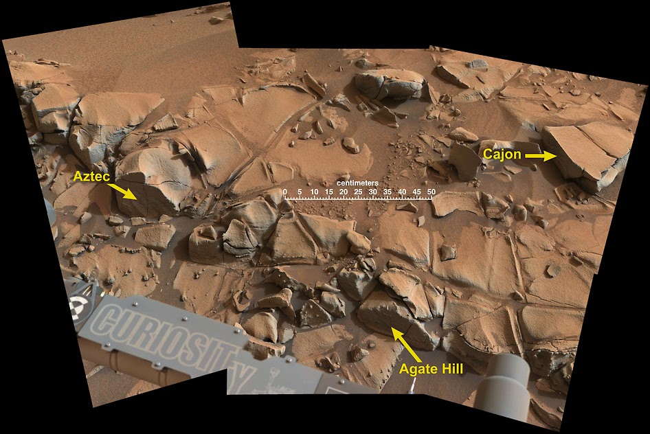
This view from the Mast Camera (Mastcam) on NASA's Curiosity Mars rover shows a swath of bedrock called "Alexander Hills," which the rover approached for close-up inspection of selected targets.

The mosaic of six Mastcam frames covers an area about 6 feet (2 meters) across.

It shows details within the workspace accessible using the rover's robotic arm from the rover's location when the view was acquired.

The component exposures were taken on Nov. 23, 2014, during the 817th Martian day, or sol, of Curiosity's work on Mars.

The colour has been approximately white-balanced to resemble how the scene would appear under daytime lighting conditions on Earth.

This annotated version shows the location of three targets selected for study, "Aztec," "Agate Hill" and "Cajon", and a 50-centimeter (20-inch) scale bar.

The location of Alexander Hills within the "Pahrump Hills" outcrop at the base of Mount Sharp is indicated on an earlier Mastcam vew

Saturday, November 22, 2014

Warmth and flowing water on early Mars, were episodic

Although the surface is now cold and desiccated, in early Mars history water formed an open-basin lake, filling the crater, forming a delta, and breaching the lower rim as water flowed to lower elevations (blue). 

New research suggests that warmer temperatures and water flow on ancient Mars were likely related to periodic volcanism early in the planet's history 

Credit: NASA /Mars Reconnaissance Orbiter Rendering by James Dickson, Brown University

Ample evidence of ancient rivers, streams, and lakes make it clear that Mars was at some point warm enough for liquid water to flow on its surface.

While that may conjure up images of a tropical Martian paradise, new research published today in Nature Geoscience throws a bit of cold water on that notion.

The study, by scientists from Brown University and Israel's Weizmann Institute of Science, suggests that warmth and water flow on ancient Mars were probably episodic, related to brief periods of volcanic activity that spewed tons of greenhouse-inducing sulfur dioxide gas into the atmosphere.

The work, which combines the effect of volcanism with the latest climate models of early Mars, suggests that periods of temperatures warm enough for water to flow likely lasted for only tens or hundreds of years at a time.

With all that's been learned about Mars in recent years, the mystery of the planet's ancient water has deepened in some respects.

The latest generation of climate models for early Mars suggests an atmosphere too thin to heat the planet enough for water to flow.

The sun was also much dimmer billions of years ago than it is today, further complicating the picture of a warmer early Mars.

"These new climate models that predict a cold and ice-covered world have been difficult to reconcile with the abundant evidence that water flowed across the surface to form streams and lakes," said James W. Head, professor of earth, environmental and planetary sciences at Brown University and co-author of the new paper with Weizmann's Itay Halevy.

Itay Halevy
"This new analysis provides a mechanism for episodic periods of heating and melting of snow and ice that could have each lasted decades to centuries."

Halevy and Head explored the idea that heating may have been linked to periodic volcanism.

Many of the geological features that suggest water flow date to around 3.7 billion years ago, a time when massive volcanoes are thought to have been active and huge lava outpourings occurred.

On Earth, however, widespread volcanism often leads to cooling rather than warming. Sulphuric acid particles and thick ash reflect the sun's rays, and that can lower temperatures, but Head and Halevy thought the effects of sulphur in Mars' dusty atmosphere might have been different.

To find out, the researchers created a model of how sulfuric acid might react with the widespread dust in the Martian atmosphere.

The work suggests that those sulphuric acid particles would have glommed onto dust particles, which would reduce their ability to reflect the sun's rays.

Meanwhile sulphur dioxide gas would produce a modest greenhouse effect, just enough to warm the Martian equatorial region so that water could flow.

Head has been doing fieldwork for years in Antarctica and thinks the climate on early Mars may have been very similar to that of the cold, desert-like McMurdo Dry Valleys.

"The average yearly temperature in the Antarctic Dry Valleys is way below freezing, but peak summer daytime temperatures can exceed the melting point of water, forming transient streams, which then refreeze," Head said.

"In a similar manner, we find that volcanism can bring the temperature on early Mars above the melting point for decades to centuries, causing episodic periods of stream and lake formation."

But as that early active volcanism on Mars ceased, so did the possibility of warmer temperatures and flowing water.

Head said the research may offer new clues about where the fossilized remnants of life might be found on Mars, if it ever existed.

"Life in Antarctica, in the form of algal mats, is very resistant to extremely cold and dry conditions and simply waits for the episodic infusion of water to 'bloom' and develop," he said.

"Thus, the ancient and currently dry and barren river and lake floors on Mars may harbor the remnants of similar primitive life, if it ever occurred on Mars."

More information: Nature Geoscience, dx.doi.org/10.1038/ngeo2293