Russell Crater Dunes on Mars Credit: HiRise camera Team, JPL, University of Arizona
The Russell Crater dune field is covered seasonally by carbon dioxide frost, and this image shows the dune field after the frost has sublimated (evaporated directly from solid to gas).
There are just a few patches left of the bright seasonal frost.
Numerous dark dust devil tracks can be seen meandering across the dunes. The face of the largest dune is lined with gullies.
The source of the gullies is unclear but could involve erosion by the seasonal carbon dioxide ice.
A closer view of the Russell Crater Dunes on Mars, in colour. Credit: HiRise camera Team, JPL, University of Arizona
More than 11 years after UK Mars probe Beagle 2 was lost, believed crashed, space scientists are set to reveal new findings about what hapened to the spacecraft.
Mystery surrounds exactly what will be disclosed by experts from the European Space Agency and the underfunded, struggling, UK Space Agency at the English National Academy of Science, known as the Royal Society in London on Friday, but it has raised hopes that orbiting spacecraft around Mars might have located the debris of the Beagle 2.
The probe was the brainchild of the eccentric, mutton-chopped Professor Colin Pillinger, of the UK’s Open University, who died suddenly in May 2014 from a brain haemorrhage.
Beagle 2 was carried to Mars by ESA’s Mars Express which remains in orbit to this day performing valuable surveys of the planet.
Beagle was due to land on Christmas Day 2003, but nothing was ever heard from the tiny craft.
Experts later concluded that its parachute had failed in the extra thin atmosphere and it hit the ground too hard.
Months later, Colin called an impromptu press conference, convinced that he had identified a speck in a photo of the martian surface as his lost probe, but later higher-resolution imagery from a NASA orbiter showed there was nothing.
This recent announcement would indicate that this time there is hope that something really has been spotted.
The panel at Friday’s announcement will include Beagle 2’s mission manager Professor Mark Sims, Dr John Bridges of Leicester University’s Space Research Centre, the European Space Agency’s director of science and robotic exploration Alvaro Giménez, and David Parker, of Durham University and the underfunded UK Space Agency.
A recent image from the HiRise camera on the NASA MRO. Credit: NASA, JPL, University of Arizona
All are remaining tight-lipped about what will be revealed, but interestingly, Dr Bridges is a member of the team working with the HiRISE camera aboard NASA's Mars Reconnaissance Orbiter, which is the only imager powerful enough to pick out the debris of Beagle 2, or any other probe, from orbit.
John Zarnecki, Emeritus Professor of Space Science, and Professor Pillinger’s former colleague, told reporters: “I don’t know what they will announce. All one can think of is that they might have got an image of the probe, but if Beagle 2 is in a thousand pieces, it is unlikely that we will have found the pieces.”
“When dear old Colin was alive, he imagined he could see the Beagle 2 in single pixels. None of us could see it, he was the only one who could. So if they really have found it this time, it would be wonderful.”
Professor Zarnecki, who headed the OU’s Planetary and Space Sciences department, said that finding Beagle 2 would be an important event, but there was no chance that it could still work.
He said: “The probe will be dead. There could be no battery life and it would have frozen probably. Electronic materials and components don’t like the cold of Mars very much.”
“The main thing is that it could tell us something about how and why it failed. We’re not going to get anything scientific out of it now, but anything we can learn about how and why it failed informs our designs for the future.
“One of the reasons why space missions on the whole are so successful is that we do learn from experience. It is similar to why flying by plane is so safe - we learn from failures.”
Professor Zarnecki had his own experiment on Beagle 2, a tiny device to measure temperature, air pressure, and wind-speed and direction, “like a weather station, but a fancy one”, he said.
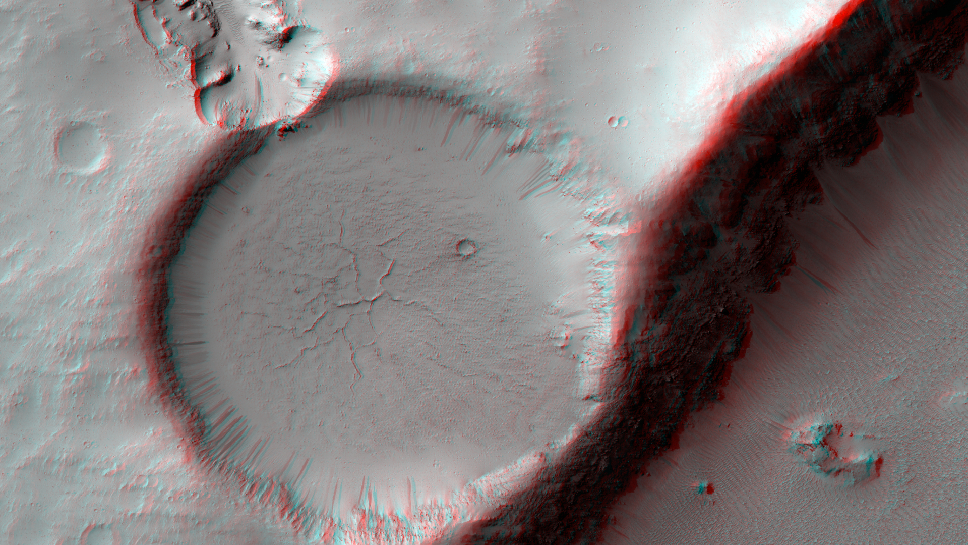
The relatively flat, shallow floor, rough surface texture, and possible cooling cracks seem to indicate that the crater was partially filled with lava.
The northern part of the image also shows a more extensive lava flow deposit that surrounds the impact ejecta of the largest impact crater in the image.
Which way did the lava flow? It might appear that the lava flowed from the north through the channel into the partially filled crater.
However, if you look at the anaglyph with your red and blue 3D glasses, it becomes clear that the partially filled crater sits on top of the large crater's ejecta blanket, making it higher than the lava flow to the north. Since lava does not flow uphill, that means the explanation isn't so simple.
We have seen much evidence for lava flows in this region that flowed to much higher levels than the present surface, then deflated or drained away.
That may have happened here: lava flowed from from north to south to fill this crater, but then it drained back to the north, carving this channel.
The topographic information that we gained from having a stereo pair let us answer a question that we could not have with only a single image.
This is a great example of why we take stereo images, where the two images are used to make a 3D image.
These images were taken of comet C/2013 A1 Siding Spring by NASA's Mars Reconnaissance Orbiter on Oct. 19, 2014, during the comet's close flyby of Mars and the spacecraft. Comet Siding Spring is on its first trip this close to the sun from the Oort Cloud at the outer fringe of the solar system. Image Credit: NASA/JPL-Caltech/University of Arizona
The images are the highest-resolution views ever acquired of a comet coming from the Oort Cloud at the fringes of the solar system. Other spacecraft have approached and studied comets with shorter orbits.
This comet's flyby of Mars provided spacecraft at the Red Planet an opportunity to investigate from close range.
The highest-resolution of images of the comet's nucleus, taken from a distance of about 86,000 miles (138,000 kilometers), have a scale of about 150 yards (138 meters) per pixel.
Telescopic observers had modeled the size of the nucleus as about half a mile, or one kilometer wide.
However, the best HiRISE images show only two to three pixels across the brightest feature, probably the nucleus, suggesting a size smaller than half that estimate.
Nasa Mars Rover Curiosity arrives at Murray Formation. Credit: NASA.
This image shows the old and new routes of NASA's Mars Curiosity rover and is composed of color strips taken by the High Resolution Imaging Science Experiment, or HiRISE, on NASA's Mars Reconnaissance Orbiter. This new route provides excellent access to many features in the Murray Formation and it will eventually pass by the Murray Formation's namesake, Murray Buttes, previously considered to be the entry point to Mt. Sharp. Credit: NASA/JPL-Caltech/Univ. of Arizona
NASA's Mars Curiosity rover has reached the Red Planet's Mount Sharp, a Mount-Rainier-size mountain at the center of the vast Gale Crater and the rover mission's long-term prime destination.
"Curiosity now will begin a new chapter from an already outstanding introduction to the world," said Jim Green, director of NASA's Planetary Science Division at NASA Headquarters in Washington.
"After a historic and innovative landing along with its successful science discoveries, the scientific sequel is upon us."
Curiosity's trek up the mountain will begin with an examination of the mountain's lower slopes.
The rover is starting this process at an entry point near an outcrop called Pahrump Hills, rather than continuing on to the previously-planned, further entry point known as Murray Buttes.
Both entry points lay along a boundary where the southern base layer of the mountain meets crater-floor deposits washed down from the crater's northern rim.
"It has been a long but historic journey to this Martian mountain," said Curiosity Project Scientist John Grotzinger of the California Institute of Technology in Pasadena.
"The nature of the terrain at Pahrump Hills and just beyond it is a better place than Murray Buttes to learn about the significance of this contact. The exposures at the contact are better due to greater topographic relief."
The decision to head uphill sooner, instead of continuing to Murray Buttes, also draws from improved understanding of the region's geography provided by the rover's examinations of several outcrops during the past year.
Curiosity currently is positioned at the base of the mountain along a pale, distinctive geological feature called the Murray formation.
Compared to neighbouring crater-floor terrain, the rock of the Murray formation is softer and does not preserve impact scars, as well. As viewed from orbit, it is not as well-layered as other units at the base of Mount Sharp.
Curiosity made its first close-up study last month of two Murray formation outcrops, both revealing notable differences from the terrain explored by Curiosity during the past year.
The first outcrop, called Bonanza King, proved too unstable for drilling, but was examined by the rover's instruments and determined to have high silicon content.
A second outcrop, examined with the rover's telephoto Mast Camera (MastCam), revealed a fine-grained, platy surface laced with sulfate-filled veins.
While some of these terrain differences are not apparent in observations made by NASA's Mars orbiters, the rover team still relies heavily on images taken by the agency's Mars Reconnaissance Orbiter (MRO) to plan Curiosity's travel routes and locations for study.
For example, MRO images helped the rover team locate mesas that are over 60 feet (18 meters) tall in an area of terrain shortly beyond Pahrump Hills, which reveal an exposure of the Murray formation uphill and toward the south.
The team plans to use Curiosity's drill to acquire a sample from this site for analysis by instruments inside the rover.
The site lies at the southern end of a valley Curiosity will enter this week from the north.
This portion of a color mosaic taken by NASA's Mars Curiosity rover shows strata exposed along the margins of the valleys in the "Pahrump Hills" region on Mars. Credit: NASA/JPL-Caltech/MSSS
Though this valley has a sandy floor the length of two football fields, the team expects it will be an easier trek than the sandy-floored Hidden Valley, where last month Curiosity's wheels slipped too much for safe crossing.
Curiosity reached its current location after its route was modified earlier this year in response to excessive wheel wear.
In late 2013, the team realized a region of Martian terrain littered with sharp, embedded rocks was poking holes in four of the rover's six wheels.
This damage accelerated the rate of wear and tear beyond that for which the rover team had planned. In response, the team altered the rover's route to a milder terrain, bringing the rover farther south, toward the base of Mount Sharp.
"The wheels issue contributed to taking the rover farther south sooner than planned, but it is not a factor in the science-driven decision to start ascending here rather than continuing to Murray Buttes first," said Jennifer Trosper, Curiosity Deputy Project Manager at NASA's Jet Propulsion Laboratory in Pasadena, California.
"We have been driving hard for many months to reach the entry point to Mount Sharp," Trosper said.
"Now that we've made it, we'll be adjusting the operations style from a priority on driving to a priority on conducting the investigations needed at each layer of the mountain."
After landing inside Gale Crater in August 2012, Curiosity fulfilled in its first year of operations its major science goal of determining whether Mars ever offered environmental conditions favourable for microbial life.
Clay-bearing sedimentary rocks on the crater floor, in an area called Yellowknife Bay, yielded evidence of a lakebed environment billions of years ago that offered fresh water, all of the key elemental ingredients for life, and a chemical source of energy for microbes.
Scarring the southern highlands of Mars is one of the Solar System's largest impact basins: Hellas, with a diameter of 2300 km and a depth of over 7 km.
Hellas is thought to have formed between 3.8 and 4.1 billion years ago, when a large asteroid hit the surface of Mars.
Since its formation, Hellas has been subject to modification by the action of wind, ice, water and volcanic activity.
Impact craters have also since pock-marked this vast basin floor, two of which are the focus of this image, taken by the High Resolution Stereo Camera (HiRise) on ESA's Mars Express on 17 December 2013. The ground resolution is about 15 metres per pixel.
These craters lie in the deepest, western portion of Hellas, and such a clear view is unusual because dust clouds typically obscure the basin floor. Indeed, this region seems to be covered by a thick blanket of dust.
The larger of the two craters is about 25 km across. A flow of material appears to have been transported from the top left of the scene and into the crater.
Zooming in to the smooth mound and the area immediately around it reveals interesting textures that likely resulted from this flow.
Flow features are also seen outside of the craters, and in particular, at the centre left of the image near the top of the frame.
Material also seems to have cascaded from the larger crater's rim and into a neighbouring smaller crater, at the far left of the image.
The morphology of many features in the Hellas Basin and its surroundings strongly suggests the presence of ice and glaciers.
For example, in the foreground and around the crater rim, polygons of patterned ground are visible which indicates the presence of water, this pattern occurs when fine grained and porous wet soil freezes.
Indeed, in the deepest parts of the basin, the atmospheric pressure is about 89% higher than at the surface, which may even offer conditions suitable for water.
Radar images from NASA's Mars Reconnaissance Orbiter suggest that some craters in Hellas might contain water-ice glaciers several hundred metres thick, buried under layers of dust.
The crater spans half the length of a football field and first appeared in March 2012. The impact that created it likely was preceded by an explosion in the Martian sky caused by intense friction between an incoming asteroid and the planet's atmosphere.
This series of events can be likened to the meteor blast that shattered windows in Chelyabinsk, Russia, last year.
The air burst and ground impact darkened an area of the Martian surface about 5 miles (8 kilometers) across.
The darkened spot appears in images taken by the orbiter's weather-monitoring camera, the Mars Colour Imager (MARCI).
Since the orbiter began its systematic observation of Mars in 2006, scientist Bruce Cantor has examined MARCI's daily global coverage, looking for evidence of dust storms and other observable weather events in the images.
Cantor is this camera's deputy principal investigator at Malin Space Science Systems, the San Diego company that built and operates MARCI and the orbiter's telescopic Context Camera (CTX).
Through his careful review of the images, he helps operators of NASA's solar-powered Mars rover, Opportunity, plan for weather events that may diminish the rover's energy. He also posts weekly Mars weather reports.
About two months ago, Cantor noticed an inconspicuous dark dot near the equator in one of the images.
"It wasn't what I was looking for," Cantor said. "I was doing my usual weather monitoring and something caught my eye. It looked usual, with rays emanating from a central spot."
Scientists using NASA's Mars Reconnaissance Orbiter found a fresh meteor-impact crater, and by golly it's big. It's the largest ever located anywhere by using before-and-after pictures.
He began examining earlier images, skipping back a month or more at a time. The images revealed that the dark spot was present a year ago, but not five years ago.
He homed in further, checking images from about 40 different dates, and pinned down the date the impact event occurred; the spot was not there up through March 27, 2012, and then appeared before the daily imaging on March 28, 2012.
Of the approximately 400 fresh crater-causing impacts on Mars that have been documented with before-and-after images, this is the only one discovered using a MARCI image, rather than an image from a higher-resolution camera.
More information: Images of the site from MARCI and from the two telescopic cameras on MRO are at: go.usa.gov/8KgJ
NASA's Curiosity Mars rover and tracks from its driving are visible in this view from orbit, acquired on April 11, 2014, by the High Resolution Imaging Science Experiment (HiRISE) camera on NASA's Mars Reconnaissance Orbiter. Image Credit: NASA/JPL-Caltech/Univ. of Arizona
Scientists using NASA's Curiosity Mars rover are eyeing a rock layer surrounding the base of a small butte, called "Mount Remarkable," as a target for investigating with tools on the rover's robotic arm.
A rover's-eye view of Mount Remarkable and surroundings as seen from Curiosity's position in that HiRISE image is available in a mosaic of images from Curiosity's Navigation Camera (Navcam).
The butte stands about 16 feet (5 meters) high. Curiosity's science team refers to the rock layer surrounding the base of Mount Remarkable as the "middle unit" because its location is intermediate between rocks that form buttes in the area and lower-lying rocks that show a pattern of striations.
Depending on what the mission scientists learn from a close-up look at the rock and identification of chemical elements in it, a site on this middle unit may become the third rock that Curiosity samples with its drill.
The rover carries laboratory instruments to analyze rock powder collected by the drill.
The mission's first two drilled samples, in an area called Yellowknife Bay near Curiosity's landing site, yielded evidence last year for an ancient lakebed environment with available energy and ingredients favorable for microbial life.
NASA's Curiosity Mars rover and its tracks are visible in this view combining information from three observations by the High Resolution Imaging Science Experiment (HiRISE) camera on NASA's Mars Reconnaissance Orbiter. The image appears three-dimensional when viewed through red-blue glasses.
Image Credit: NASA/JPL-Caltech/Univ. of Arizona
Mars Reconnaissance Orbiter (MRO) spacecraft shows a sand dune field in a Southern highlands crater on the red planet. The sun lay only 5 degrees above the horizon when the spacecraft captured this image, producing deep shadows, with dune crests sticking up sharply into the sunlight. The bright patches which appear bluish in enhanced color arise from seasonal frost accumulating as this hemisphere approaches winter. Credit: NASA HiRISE
A vast ocean may have once covered a third of the Red Planet. Credit: ESA, C. Carreau
Did a vast ocean once cover Mars' northern plains?
The idea has been hotly debated among scientists for the past 20 years, ever since Viking Orbiter images revealed possible ancient shorelines near the pole.
Later findings even suggested that the primordial ocean, dubbed Oceanus Borealis, could have covered a third of the planet.
But even if the evidence has mounted steadily, fostering our hopes of finding signs of past life on the Red Planet, the case for an ancient Martian ocean remains unsettled.
Today, large fields of boulder-size rocks blanket parts of Mars' northern plains.
By pointing to analogue geological features on our Earth, Moscardelli suggests that the boulders were delivered to their current locations by catastrophic underwater landslides, bolstering evidence for an ancient Martian ocean.
So Moscardelli is not reporting their presence as something new, but rather a new interpretation of the processes behind their origin.
The paper was published this month in a journal of the Geological Society of America.
Terrestrial Analogy
In the past, geoscientists thought of ocean sediments as mostly fine-grained, floating in the water column and settling like a slow "rain" on the sea floor, Moscardelli explained. But we now know it's not the only possible scenario.
Boulder-size rocks in Arcadia Planitia, northern lowland of Mars (HiRISE ESP_019853_2410). Credit: NASA (Moscardelli 2014)
"We know that 'submarine landslides' can transport big boulders, sometimes as big as a house, for hundreds of kilometers into the deep-water of the Earth oceans," she said.
"Imagine a huge landslide affecting the entire state of Texas, but happening in the ocean."
She even shows that these underwater events can affect huge areas, as with a massive landslide that covered thousands of square kilometers in the Barents Sea, north of Russia, about a million years ago.
Some scientists have suggested that the boulders of Mars's northern plain could be the product of meteorite impacts. But to Moscardelli, that's not a fitting theory.
"That's possible for some of the boulders, especially those found close to craters," she says. "But how do you explain boulder fields that can cover thousands of square kilometers without any impact craters around?
"The submarine hypothesis provides a feasible alternative."


 Posts
Posts