Showing posts with label Mars Odyssey. Show all posts

Sunday, October 19, 2014

NASA's Mars Reconnaissance Orbiter safely watches Comet Siding Spring FlyBy

NASA's Mars Reconnaissance Orbiter, which has sent home more data about Mars than all other missions combined, is also now providing data about a comet that buzzed The Red Planet today (Oct. 19).

The orbiter continues operating in good health after sheltering behind Mars during the half hour when high-velocity dust particles from comet C/2013 A1 Siding Spring had the most chance of reaching the paths of Mars orbiters.

The Comet Siding Spring C/2013 A1 is indicated on this image as it passes Mars, seen here shining brightly on the bottom left.

Credit: Slooh

maintained radio communications with Earth throughout the comet's closest approach, at 11:27 a.m. PDT (2:27 p.m. EDT), and the peak dust-risk period centered about 100 minutes later.

"The spacecraft performed flawlessly throughout the comet flyby," said Mars Reconnaissance Orbiter Project Manager Dan Johnston of NASA's Jet Propulsion Laboratory, Pasadena, California. "It maneuvered for the planned observations of the comet and emerged unscathed."

Following the critical period of dust flux, the orbiter is communicating at 1.5 megabits per second with NASA's Deep Space Network.

It remained on Side A of its two redundant computers, and all subsystems are working as expected.

The remainder of the NASA Mars orbiters, Mars Express and ISRO's MOM, appear to be in good health and unaffected by the comet flyby.

An artist impression of the passing of Comet Siding Spring as seen by Curiosity Rover on Mars.

Credit: SLOOH

NASA, ESA and ISRO Satellites and Rovers observe Mars atmosphere and Comet Siding Spring


This artist's concept illustration depicts the Comet Siding Spring (2013 A1) flyby Mars and illustrates some of the NASA, ESA and ISRO satellites positioned to record the event.

Credit: Nasa, ESA

A comet the size of a small mountain is about to skim past Mars, and NASA hopes its spacecraft will be able to photograph the once-in-a-million-years encounter.

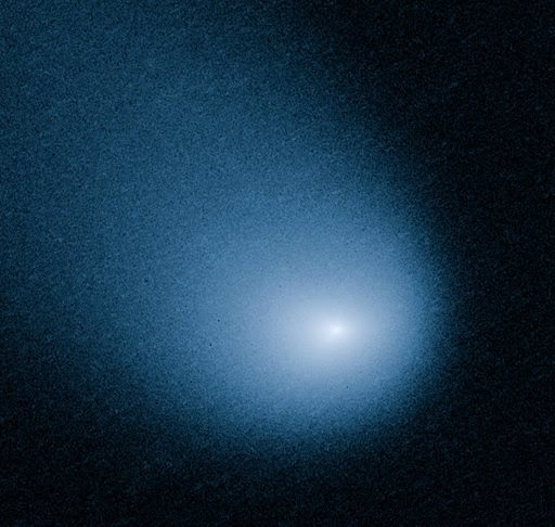
This March 27, 2014 image provided by NASA, ESA, and J.-Y. Li shows comet C/2013 A1, also known as Siding Spring, as captured by Wide Field Camera 3 on NASA's Hubble Space Telescope. 

Credit: AP Photo /NASA, ESA, J.-Y. Li

The comet, known as Siding Spring (C/2013 A1), is set to hurtle past Mars at a close distance of about 88,000 miles (141,600 kilometers).

The closest pass is expected to happen Sunday at 2:27 pm (1827 GMT).

Astronomers do not expect it will come any where near colliding with Mars, but they do hope it will be close enough to reveal clues about the origins of the solar system.

That is because the comet is believed to have originated billions of years ago in the Oort Cloud, a distant region of space at the outskirts of the solar system.

"Comets such as C/2013 A1 are essentially dirty icy snowballs with rocks and dust embedded in frozen gasses," said Dan Brown, an astronomy expert at Nottingham Trent University.

"It is on its first run towards the center of our solar system and its material is virtually unchanged by the rays of the sun and can give us an insight to the material composition of our early solar system 4.6 billion years ago."

Fast and powdery
The comet is flying through space at a breakneck speed of 122,400 miles per hour.

Another interesting thing about the comet, about a mile wide in diameter, is that it is only about as solid as a pile of talcum powder.

Illustration of the trajectory of Siding Spring, which will come close to Mars on Sunday.

NASA has manuevered its Mars orbiters to the far side of the planet so they won't be damaged by the comet's high-speed debris.

Even as the Mars Reconnaissance Orbiter, Mars Odyssey and MAVEN have been repositioned to avoid hazardous dust, scientists hope they will be able to capture a trove of data about the flyby for Earthlings to study.

NASA's two rovers, Curiosity and Opportunity, will turn their cameras skyward and send back pictures of the comet's pass in the coming days, weeks and months, the US space agency said.

"The orbiters will keep a close eye on the show," said Rebecca Johnson, editor of StarDate magazine.

"They'll study the comet itself, which is a small chunk of ice and rock. They'll also study the cloud of gas and dust around the comet, as well as its long tail," she said.

"And they'll measure how the gas and dust interact with the Martian atmosphere."

The comet has traveled more than one million years to make its first pass by Mars, and will not return for another million years, after it completes its next long loop around the sun.

The comet was discovered by Robert McNaught at ANU's Siding Spring Observatory in January 2013.

Its flyby of Mars is not likely to be visible to sky watchers on Earth.

But the encounter is of great interest to scientists, particularly since there are so many spacecraft on and around Mars to record it.

"As it zips toward the sun, it gives scientists a chance to see a relic from the distant past, a snowball that preserves the same ingredients that gave birth to our own world," said Johnson.

This image shows just how many satellites and probes humanity has sent to Mars. Some more successful than others, and we still have much to learn about our near neighbour.

Sunday, July 27, 2014

NASA’s Mars Spacecraft Maneuvers to Prepare for Close Comet Flyby

This graphic depicts the orbit of comet C/2013 A1 Siding Spring as it swings around the sun in 2014. 

On Oct. 19, the comet will have a very close pass at Mars. 

Its nucleus will miss Mars by about 82,000 miles (132,000 kilometers).

Image Credit: NASA/JPL-Caltech

NASA is taking steps to protect its Mars orbiters, while preserving opportunities to gather valuable scientific data, as Comet C/2013 A1 Siding Spring heads toward a close flyby of Mars on Oct. 19.

The comet’s nucleus will miss Mars by about 82,000 miles (132,000 kilometers), shedding material hurtling at about 35 miles (56 kilometers) per second, relative to Mars and Mars-orbiting spacecraft.

At that velocity, even the smallest particle, estimated to be about one-fiftieth of an inch (half a millimeter) across, could cause significant damage to a spacecraft.

NASA currently operates two Mars orbiters, with a third on its way and expected to arrive in Martian orbit just a month before the comet flyby.

Teams operating the orbiters plan to have all spacecraft positioned on the opposite side of the Red Planet when the comet is most likely to pass by.

"Three expert teams have modeled this comet for NASA and provided forecasts for its flyby of Mars," explained Rich Zurek, chief scientist for the Mars Exploration Program at NASA's Jet Propulsion Laboratory (JPL) in Pasadena, California.

"The hazard is not an impact of the comet nucleus, but the trail of debris coming from it. Using constraints provided by Earth-based observations, the modeling results indicate that the hazard is not as great as first anticipated."

"Mars will be right at the edge of the debris cloud, so it might encounter some of the particles -- or it might not."

During the day's events, the smallest distance between Siding Spring's nucleus and Mars will be less than one-tenth the distance of any known previous Earthly comet flyby.

The period of greatest risk to orbiting spacecraft will start about 90 minutes later and last about 20 minutes, when Mars will come closest to the center of the widening dust trail from the nucleus.

NASA's Mars Reconnaissance Orbiter (MRO)
NASA's Mars Reconnaissance Orbiter (MRO) made one orbit-adjustment maneuver on July 2 as part of the process of repositioning the spacecraft for the Oct. 19 event. An additional maneuver is planned for Aug. 27.

NASA's Mars Odyssey orbiter
The team operating NASA's Mars Odyssey orbiter is planning a similar maneuver on Aug. 5 to put that spacecraft on track to be in the right place at the right time, as well.

NASA's Mars Atmosphere and Volatile Evolution (MAVEN)
NASA's Mars Atmosphere and Volatile Evolution (MAVEN) spacecraft is on its way to the Red Planet and will enter orbit on Sept. 21.

The MAVEN team is planning to conduct a precautionary maneuver on Oct. 9, prior to the start of the mission's main science phase in early November.

In the days before and after the comet's flyby, NASA will study the comet by taking advantage of how close it comes to Mars.

Researchers plan to use several instruments on the Mars orbiters to study the nucleus, the coma surrounding the nucleus, and the tail of Comet C/2013 A1 Siding Spring, as well as the possible effects on the Martian atmosphere.

This particular comet has never before entered the inner solar system, so it will provide a fresh source of clues to our solar system's earliest days.

MAVEN will study gases coming off the comet's nucleus into its coma as it is warmed by the sun.

MAVEN also will look for effects the comet flyby may have on the planet’s upper atmosphere and observe the comet as it travels through the solar wind.

Odyssey will study thermal and spectral properties of the comet's coma and tail. MRO will monitor Mars’ atmosphere for possible temperature increases and cloud formation, as well as changes in electron density at high altitudes.

The MRO team also plans to study gases in the comet’s coma. Along with other MRO observations, the team anticipates this event will yield detailed views of the comet’s nucleus and potentially reveal its rotation rate and surface features.

NASA Mars MSL Curiosity rover
Mars' atmosphere, though much thinner than Earth's, is thick enough that NASA does not anticipate any hazard to the Opportunity and Curiosity rovers on the planet's surface, even if dust particles from the comet hit the atmosphere and form into meteors.

Rover cameras may be used to observe the comet before the flyby, and to monitor the atmosphere for meteors while the comet's dust trail is closest to the planet.

Observations from Earth-based and space telescopes provided data used for modeling to make predictions about Siding Spring's Mars flyby, which were in turn used for planning protective maneuvers.

The three modeling teams were headed by researchers at the University of Maryland in College Park, the Planetary Science Institute in Tucson, Arizona, and JPL.

NASA Seeks Proposals for Commercial Mars Data Relay Satellites

One possible area for improvement is laser or optical communications. NASA successfully demonstrated laser communications technology in October 2013 with its Lunar Atmosphere and Dust Environment Explorer (LADEE) mission.

LADEE made history using a pulsed laser beam to transmit data over 239,000 miles from the moon to Earth at a record-breaking download rate of 622 megabits-per-second (Mbps).

NASA has issued a Request for Information (RFI) to investigate the possibility of using commercial Mars-orbiting satellites to provide telecommunications capabilities for future robotic missions to the Red Planet.

"We are looking to broaden participation in the exploration of Mars to include new models for government and commercial partnerships," said John Grunsfeld, associate administrator of NASA's Science Mission Directorate at the agency's headquarters in Washington.

"Depending on the outcome, the new model could be a vital component in future science missions and the path for humans to Mars."

The RFI details possible new business models that would involve NASA contracting to purchase services from a commercial service provider, which would own and operate one or more communication relay orbiters.

The solicitation is open to all types of organizations including U.S. industry, universities, nonprofits, NASA centers, and federally funded research and development centers, in addition to U.S. government and international organizations.

NASA is interested in exploring alternative models to sustain and evolve its Mars' communications relay infrastructure to avoid a communications gap in the 2020s.

The RFI encourages innovative ideas for cost-effective approaches that provide relay services for existing landers, as well as significantly improving communications performance.

Lisa May
Mars landers and rovers currently transmit their science data and other information to Earth either by a direct communication link or via orbiting satellites acting as relay stations.

The direct link is severely limited because of mass, volume, and power limits on the rovers.

To address these limits, NASA's Mars Exploration Program currently uses relay radios on its Mars science orbiters.

The spacecraft carry high-gain antennas and higher power transmitters that provide very high-rate, energy-efficient links between orbiters and surface missions as the obiters pass overhead.

Mars Reconnassaince Orbiter (MRO)
MARS Relay Strategy
"The current Mars relay strategy has been extremely successful in providing the science and engineering data returned from the Martian surface over the past decade," said Lisa May, lead program executive for NASA's Mars Exploration Program.

Because NASA has launched science orbiters to Mars on a steady cadence, the current strategy has been cost effective.

MAVEN
However, NASA has no scheduled Mars science orbiters after MAVEN arrives on the Red Planet in the fall.

This creates the need to identify cost-effective options to ensure continuity of reliable, high-performance telecommunications relay services for the future.

"Looking ahead, we need to seriously explore the possibility of the commercialization of Mars communications services," said May.

"This will offer advantages to NASA, while also providing appropriate return-on-investment to the service provider."

Sunday, July 20, 2014

ASU USGS project: THEMIS Development of sharpest map of Mars' surface properties

A small impact crater on Mars named Gratteri, 4.3 miles (6.9 km) wide, lies at the center of large dark streaks. 

Unlike an ordinary daytime photo, this nighttime image shows how warm various surface areas are. 

Brighter tones mean warmer temperatures, which indicate areas with rockier surface materials. 

Darker areas indicate cooler and dustier terrain. For example, the bright narrow rings scattered across the image show where rocks are exposed on the uplifted rims of impact craters. 

Broad, bright areas show expanses of bare rock and durable crust. Fine-grain materials, such as dust and sand, show up as dark areas, most notably in the streaky rays made of fine material flung away in the aftermath of the meteorite's impact. 

Image courtesy NASA/JPL-Caltech/Arizona State University.

A heat-sensing camera designed at Arizona State University has provided data to create the most detailed global map yet made of Martian surface properties.

The map uses data from the Thermal Emission Imaging System (THEMIS), a nine-band visual and infrared camera on NASA's Mars Odyssey orbiter.

A version of the map optimized for scientific researchers is available at the U.S. Geological Survey (USGS).

The new Mars map was developed by the Geological Survey's Robin Fergason at the USGS Astrogeology Science Center in Flagstaff, Arizona, in collaboration with researchers at ASU's Mars Space Flight Facility.

The work reflects the close ties between space exploration efforts at Arizona universities and the U.S. Geological Survey.

"We used more than 20,000 THEMIS nighttime temperature images to generate the highest resolution surface property map of Mars ever created," says Fergason, who earned her doctorate at ASU in 2006.

"Now these data are freely available to researchers and the public alike."

Surface properties tell geologists about the physical nature of a planet or moon's surface.
  • Is a particular area coated with dust, and if so, how thick is it likely to be?
  • Where are the outcrops of bedrock? 
  • How loose are the sediments that fill this crater or that valley? 
A map of surface properties lets scientists begin to answer questions such as these.


Darker means cooler and dustier
The new map uses nighttime temperature images to derive the "thermal inertia" for areas of Mars, each the size of a football field.

Thermal inertia is a calculated value that represents how fast a surface heats up and cools off.

As day and night alternate on Mars, loose, fine-grain materials such as sand and dust change temperature quickly and thus have low values of thermal inertia.

Bedrock represents the other end of the thermal inertia range: because it cools off slowly at night and warms up slowly by day, it has a high thermal inertia.

"Darker areas in the map are cooler at night, have a lower thermal inertia and likely contain fine particles, such as dust, silt or fine sand," Ferguson says.

The brighter regions are warmer, she explains, and have surfaces with higher thermal inertia. These consist perhaps of coarser sand, surface crusts, rock fragments, bedrock or combinations of these materials.

The designer and principal investigator for the THEMIS camera is Philip Christensen, Regents' Professor of Geological Sciences in the School of Earth and Space Exploration, part of the College of Liberal Arts and Sciences on the Tempe campus.

NB: Four years ago, Christensen and ASU researchers used daytime THEMIS images to create a global Mars map depicting the planet's landforms, such as craters, volcanoes, outflow channels, landslides, lava flows and other features.


"A tremendous amount of effort has gone into this great global product, which will serve engineers, scientists and the public for many years to come," Christensen says.

"This map provides data not previously available, and it will enable regional and global studies of surface properties. I'm eager to use it to discover new insights into the recent surface history of Mars."

As Fergason notes, the map has an important practical side. "NASA used THEMIS images to find safe landing sites for the Mars Exploration Rovers in 2004, and for Curiosity, the Mars Science Laboratory rover, in 2012," she says.

"THEMIS images are now helping NASA select a landing site for its next Mars rover in 2020."

Tuesday, July 8, 2014

USGS: New Red Planet Map Shows Water Shaped Mars' Highlands

A small portion of the 118-megabyte new map of Mars' southern highlands published by the United States Geological Survey (USGS).

Credit: Scott Mest and David Crown/USGS

A very detailed new map of Mars' southern highlands shows how profoundly liquid water sculpted the region long ago, scientists say.

David Crown
"This new map depicts the complicated sequence of geologic processes that have served to modify ancient, rugged highland terrains surrounding the Hellas impact basin and shows evidence for the persistent effects of water and ice in degrading the Martian surface," David Crown, of the Planetary Science Institute (PSI) in Tucson, Arizona, said in a statement.

Crown and his PSI colleague Scott Mest produced the new map, which was published by the United States Geological Survey (USGS).

It covers the area on Mars from 27.5 to 42.5 degrees south latitude and 110 to 115 degrees east longitude.

Figure showing the area covered (crosshatched) by the USGS's new map of Mars' southern highlands.

Credit: Scott Mest and David Crown/USGS

The map sheds particular light on the evolution of two canyon systems in the southern highlands, Waikato Vallis and Reull Vallis.

Researchers think both canyons formed when underground water came to the surface, collapsing the ground.

Images from NASA's two Viking orbiters, which began circling the Red Planet in the 1970s, seemed to suggest that Waikato Vallis and Reull Vallis were part of the same ancient canyon system.

But the new map, constructed with data collected by NASA's Mars Reconnaissance Orbiter (MRO), Mars Odyssey and Mars Global Surveyor spacecraft, reveals that Waikato and Reull were actually separate canyons separated by a plains landscape known as Eridania Planitia.

In fact, water released from Waikato Vallis formed a shallow lake in these plains long ago, scientists said.

While Waikato and Reull are the dominant landforms in the area, the new map also shows many small channels that flowing water carved into the southern highlands, likely about the same time the two big canoyns were forming, researchers said.

"Most highland peaks and the walls of many impact craters show evidence that ice-rich sediments flowed downhill, forming features that resemble rock glaciers on Earth; these features represent the most recent water-related activity in the area, and may be active today," PSI representatives wrote in a description of the new map.

You can download a free copy of the 118-megabyte Mars map from the USGS website.

Monday, March 3, 2014

MAVEN's Electra Ultra High Frequency Transceiver

This radio hardware, the Electra UHF Transceiver on NASA's MAVEN mission to Mars, is designed to provide communication relay support for robots on the surface of Mars.

The team operating NASA's Mars Atmosphere and Volatile Evolution (MAVEN) mission successfully completed, on Feb. 19, 2014, the initial post-launch power-on and checkout of the spacecraft's Electra Ultra High Frequency Transceiver.

This wraps up the initial checkouts of all payloads on the MAVEN spacecraft, with everything performing as expected.

MAVEN will examine the upper atmosphere of Mars to provide understanding about processes that led to the loss of much of the original Martian atmosphere.

Data and analysis could tell planetary scientists the history of climate change on the Red Planet and provide further information on the history of planetary habitability.

The spacecraft was launched on Nov. 18, 2013, and will enter orbit around Mars in September 2014.

The Electra radio payload is part of the NASA Mars Exploration Program's Mars Relay Network.

This network is composed of orbiters, including NASA's Mars Odyssey and Mars Reconnaissance Orbiter (MRO), that provide reliable, high-data-rate relay communications links to landers on the surface of Mars, including NASA's Opportunity and Curiosity rovers.

Using relay via orbiters, compared with the rovers' capability to transmit directly to Earth, greatly increases science data return from the Martian surface.

MAVEN will be available to provide relay services on a contingency basis during its prime science mission and may routinely provide relay support during an anticipated extended mission.

MAVEN's Electra payload is provided and operated by NASA's Jet Propulsion Laboratory, Pasadena, Calif.

Since launch, the mission team has checked out MAVEN's three suites of science instruments. The Particles and Fields Package contains six instruments to characterize the solar wind and the ionosphere of Mars.

The Remote Sensing Package will determine global characteristics of the upper atmosphere and ionosphere.

The Neutral Gas and Ion Mass Spectrometer will measure the composition of Mars' upper atmosphere.

Monday, February 17, 2014

Mars MRO HiRise: New evidence for ancient ocean

A vast ocean may have once covered a third of the Red Planet. 

Credit: ESA, C. Carreau

Did a vast ocean once cover Mars' northern plains?

The idea has been hotly debated among scientists for the past 20 years, ever since Viking Orbiter images revealed possible ancient shorelines near the pole.

Later findings even suggested that the primordial ocean, dubbed Oceanus Borealis, could have covered a third of the planet.

But even if the evidence has mounted steadily, fostering our hopes of finding signs of past life on the Red Planet, the case for an ancient Martian ocean remains unsettled.

Lorena Moscardelli
Now a new study by Lorena Moscardelli, a geologist at the University of Texas, Austin, puts forward yet another line of evidence.

Today, large fields of boulder-size rocks blanket parts of Mars' northern plains.

By pointing to analogue geological features on our Earth, Moscardelli suggests that the boulders were delivered to their current locations by catastrophic underwater landslides, bolstering evidence for an ancient Martian ocean.


The boulders were spotted by the HiRISE camera on the Mars Reconnaissance Orbiter a while ago.

So Moscardelli is not reporting their presence as something new, but rather a new interpretation of the processes behind their origin.

The paper was published this month in a journal of the Geological Society of America.

Terrestrial Analogy
In the past, geoscientists thought of ocean sediments as mostly fine-grained, floating in the water column and settling like a slow "rain" on the sea floor, Moscardelli explained. But we now know it's not the only possible scenario.

Boulder-size rocks in Arcadia Planitia, northern lowland of Mars (HiRISE ESP_019853_2410). 

Credit: NASA (Moscardelli 2014)

"We know that 'submarine landslides' can transport big boulders, sometimes as big as a house, for hundreds of kilometers into the deep-water of the Earth oceans," she said.

"Imagine a huge landslide affecting the entire state of Texas, but happening in the ocean."

In her new study, Moscardelli documents several sites where these events have occurred on Earth, such as the Pennsylvanian Jackfork Group of south-central Arkansas; the outcrops of the Guandacol Formation in the Pangazo Basin, Argentina; or in the Santos Basin, offshore Brazil.

She even shows that these underwater events can affect huge areas, as with a massive landslide that covered thousands of square kilometers in the Barents Sea, north of Russia, about a million years ago.

Some scientists have suggested that the boulders of Mars's northern plain could be the product of meteorite impacts. But to Moscardelli, that's not a fitting theory.

"That's possible for some of the boulders, especially those found close to craters," she says. "But how do you explain boulder fields that can cover thousands of square kilometers without any impact craters around?

"The submarine hypothesis provides a feasible alternative."

More information: Paper: www.geosociety.org/gsatoday/

Saturday, February 15, 2014

Mars ASU THEMIS camera to get new views of Red Planet

ASU's Thermal Emission Imaging System (THEMIS) is taking regular temperature measurements of the ground as the orbit of NASA's Mars Odyssey spacecraft drifts toward a time of day that will give THEMIS views of Mars around sunrise and sunset. 

This will be the first systematic observations of these times of day in more than a generation. 

Here, THEMIS is imaging the floor of Gale Crater, using its visual wavebands to create a color view of the area where Mars rover Curiosity (too small to be imaged) is exploring for ancient habitable environments. 

Image courtesy NASA /JPL-Caltech /Arizona State University.

For the first time since the Viking Mars mission of the 1970s, which ended more than a generation ago, scientists will soon begin systematic observations of Mars from orbit at times of day around local sunrise and sunset.

The instrument they will use is the Thermal Emission Imaging System (THEMIS) camera, designed at Arizona State University.

Mars Odyssey carries three main science instruments: The Gamma Ray Spectrometer (GRS), the Thermal Emission Imaging System (THEMIS), and the Mars Radiation Environment Experiment (MARIE).

The spacecraft has been drifting toward the new orbit for more than a year, and a small engine burn on Feb. 11 accelerated the drift so it can finalize the orbit in November of 2015.

During the transition, THEMIS will continue observations as the orbital time of day changes.

Philip Christensen
"We don't know exactly what we'll find when we get to an orbit where we see Mars just after sunrise," says Philip Christensen, designer and principal investigator for THEMIS.

He is a Regents' Professor of Geological Sciences in ASU's School of Earth and Space Exploration on the Tempe campus. Christensen developed the post-orbit change observing plan.

THEMIS is a multi-band camera that images Mars in nine infrared (heat-sensitive) "colours" and five visible ones. It was launched on Mars Odyssey in April 2001 and reached the Red Planet in October that year.

The spacecraft spent several months dipping into the Martian atmosphere to regularize its orbit, and THEMIS began science imaging in February 2002.

With more than 12 years elapsed since arrival, Mars Odyssey is the longest-working Mars spacecraft of any nation.


Morning and evening on Mars
Besides revealing landscapes in sharp relief, thanks to the low sun angle, the new orbital time of day for THEMIS promises to let scientists explore frosts, ground fogs, early morning clouds and hazes, and other transient atmosphere-related features that usually vanish as the Martian day goes on.

"We know that in places, carbon dioxide frost forms overnight," says Christensen. "And then it sublimates immediately after sunrise."

"What would this process look like in action? How would it behave? We've never observed this kind of phenomenon directly."

He notes that the Martian atmosphere is more variable than scientists have appreciated in the past.

"We can look for seasonal differences," says Christensen. "Are fogs more common in winter or spring? Do they vary from day to day? From one part of the year to another? From year to year? We'll check it out."

In addition, THEMIS will measure surface temperatures at thousands of locations. These observations can yield insight about materials in the ground and about temperature-driven processes.

These include warm-season flows of water or brine seen on some slopes, and gas-and-sand geysers fed by spring thawing of carbon dioxide ice near Mars' south pole.

Jeffrey Plaut
"We're teaching an old spacecraft new tricks," says Odyssey project scientist Jeffrey Plaut at NASA's Jet Propulsion Laboratory in Pasadena, California.

"We will be in position to do something that has never been done systematically: to watch how morning fog, clouds and surface frost develop at different times of year."

After Mars Odyssey reaches its intended orbit of 6:45 a.m. and p.m. (local time) in November 2015, mission engineers expect Odyssey will have enough propellant for nine to 10 more years of operation, an important matter for ongoing Mars exploration.

Besides conducting its own observations, Odyssey also serves as a crucial communications relay to Earth for the two active rovers, Curiosity and Opportunity, operating on the Martian surface.

"Mars is a dynamic world," says Christensen. "And for a generation, we've not been positioned to explore this part of it so thoroughly."

Monday, June 11, 2012

NASA MARS Odyssey Orbiter Puts Itself into Standby Safe Mode

NASA's Mars Odyssey orbiter put itself into a precautionary standby status early Friday, June 8, Universal Time (Thursday evening, Pacific Time), when the spacecraft detected unexpected characteristics in movement of one of its reaction wheels.

The spacecraft uses three of these wheels as the primary method for adjusting and maintaining its orientation. It carries a spare reaction wheel.

Odyssey's flight team is in communication with the spacecraft while planning actions in response to Odyssey entering the standby status, which is called safe mode.

"The spacecraft is safe, and information we've received from it indicates the problem is limited to a single reaction wheel," said Odyssey Mission Manager Chris Potts of NASA's Jet Propulsion Laboratory, Pasadena, Calif.

"The path forward is evaluating the health of the reaction wheel and our options for proceeding."

Because the trigger for the incident was limited to a reaction wheel, the spacecraft did not need to completely reboot its computer, as it had in some earlier safing incidents during its record-setting decade of service at Mars. The flight team will be developing a recovery timeline in coming days.

NASA launched the Mars Odyssey spacecraft on April 7, 2001. Odyssey arrived at Mars Oct. 24, 2001.

After arrival, the spacecraft spent several months using a technique called aerobraking, which involved dipping into the Martian atmosphere to adjust its orbit. In February 2002, science operations began. Odyssey has worked at Mars longer than any other mission in history.

Besides conducting its own scientific observations, it serves as a communication relay for robots on the surface of Mars.

NASA plans to use Odyssey and the newer Mars Reconnaissance Orbiter as communication relays for the Mars Science Laboratory mission during the landing and Mars-surface operations of that mission's Curiosity rover.

Friday, September 2, 2011

NASA Mars: Rover Opportunity at Work Examining 'Tisdale 2'

NASA's Mars Exploration Rover Opportunity used its front hazard-avoidance camera to take this picture showing the rover's arm extended toward a light-toned rock, "Tisdale 2"

This was done during the 2,695th Martian day, or sol, of the rover's work on Mars (Aug. 23, 2011). Tisdale 2 is about 12 inches (30 centimeters) tall.

The rover used two instruments on the robotic arm, the microscopic imager and the alpha particle X-ray spectrometer, to examine Tisdale 2. In this image, the turret at the end of the arm is positioned so that the microscopic imager is facing the rock.

Tisdale 2 and other rocks on the ground beyond it were apparently ejected by the impact that excavated a 66-foot-wide (20-meter-wide) crater, called "Odyssey," which is nearby to the left (north) of this scene.

Odyssey and these rocks are on a low ridge called "Cape York," which is a segment of the western rim of Endeavour crater. Endeavour is about 14 miles (22 kilometers) in diameter. Portions of the interior and eastern rim of Endeavour are visible near the top of this image.

Image Credit: NASA/JPL-Caltech

Wednesday, December 15, 2010

NASA Mars Odyssey: Udzha Crater

Although it is 45 kilometers (28 miles) wide, countless layers of ice and dust have all but buried Udzha Crater.

Udzha lies near the edge of the northern polar cap, and only the topmost edges of its crater rim rise above the polar deposits to hint at its circular shape.

The image was taken by the Thermal Emission Imaging System instrument on NASA's Mars Odyssey orbiter and posted in a special December 2010 set marking the occasion of Odyssey becoming the longest-working Mars spacecraft in history. The pictured location on Mars is 81.8 degrees north latitude, 77.2 degrees east longitude.

NASA's Jet Propulsion Laboratory manages the 2001 Mars Odyssey mission for NASA's Science Mission Directorate, Washington, D.C. The Thermal Emission Imaging System (THEMIS) was developed by Arizona State University, Tempe, in collaboration with Raytheon Santa Barbara Remote Sensing.

The THEMIS investigation is led by Dr. Philip Christensen at Arizona State University. Lockheed Martin Astronautics, Denver, is the prime contractor for the Odyssey project, and developed and built the orbiter. Mission operations are conducted jointly from Lockheed Martin and from JPL, a division of the California Institute of Technology in Pasadena.

Image credit: NASA/JPL-Caltech/ASU

More Mars Odyssey Images here

Sunday, July 25, 2010

NASA's Mars Odyssey orbiter put itself into a safe standby mode


Odyssey has been orbiting Mars since 2001.


NASA's Mars Odyssey orbiter put itself into a safe standby mode on Wednesday, July 14, and the team operating the spacecraft has begun implementing careful steps designed to resume Odyssey's science and relay operations this week.

Engineers have diagnosed the cause of the safe-mode entry as the spacecraft's proper response to unexpected performance by an electronic encoder.

That encoder controls motion of a gimbal that adjusts the position of the solar array. Odyssey switched to a redundant encoder, and there is no sign of any mechanical problem with the gimbal.

Commands from Earth have switched Odyssey back to using its high-gain antenna. The programmed response to the detected problem on July 14 initially shifted the spacecraft to slower communication via its low-gain antenna.

The spacecraft team recovered downward-pointing operations, out of safe mode, on Friday, July 16. "We expect to be back to full operations this week," said Odyssey Project Manager Phil Varghese of NASA's Jet Propulsion Laboratory, Pasadena, Calif.

Odyssey has been orbiting Mars since 2001. In addition to its own major scientific discoveries and continuing studies of the planet, the Odyssey mission has played important roles in supporting the missions of the Mars rovers Spirit and Opportunity and the Phoenix Mars Lander.

The rover Opportunity was not able to transmit data to ground controllers via Odyssey while the orbiter was in safe mode. Science activities were delayed, but critical activities have not been affected.