Showing posts with label satellites. Show all posts

Sunday, October 19, 2014

NASA, ESA and ISRO Satellites and Rovers observe Mars atmosphere and Comet Siding Spring


This artist's concept illustration depicts the Comet Siding Spring (2013 A1) flyby Mars and illustrates some of the NASA, ESA and ISRO satellites positioned to record the event.

Credit: Nasa, ESA

A comet the size of a small mountain is about to skim past Mars, and NASA hopes its spacecraft will be able to photograph the once-in-a-million-years encounter.

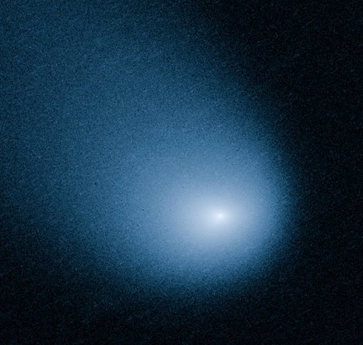
This March 27, 2014 image provided by NASA, ESA, and J.-Y. Li shows comet C/2013 A1, also known as Siding Spring, as captured by Wide Field Camera 3 on NASA's Hubble Space Telescope. 

Credit: AP Photo /NASA, ESA, J.-Y. Li

The comet, known as Siding Spring (C/2013 A1), is set to hurtle past Mars at a close distance of about 88,000 miles (141,600 kilometers).

The closest pass is expected to happen Sunday at 2:27 pm (1827 GMT).

Astronomers do not expect it will come any where near colliding with Mars, but they do hope it will be close enough to reveal clues about the origins of the solar system.

That is because the comet is believed to have originated billions of years ago in the Oort Cloud, a distant region of space at the outskirts of the solar system.

"Comets such as C/2013 A1 are essentially dirty icy snowballs with rocks and dust embedded in frozen gasses," said Dan Brown, an astronomy expert at Nottingham Trent University.

"It is on its first run towards the center of our solar system and its material is virtually unchanged by the rays of the sun and can give us an insight to the material composition of our early solar system 4.6 billion years ago."

Fast and powdery
The comet is flying through space at a breakneck speed of 122,400 miles per hour.

Another interesting thing about the comet, about a mile wide in diameter, is that it is only about as solid as a pile of talcum powder.

Illustration of the trajectory of Siding Spring, which will come close to Mars on Sunday.

NASA has manuevered its Mars orbiters to the far side of the planet so they won't be damaged by the comet's high-speed debris.

Even as the Mars Reconnaissance Orbiter, Mars Odyssey and MAVEN have been repositioned to avoid hazardous dust, scientists hope they will be able to capture a trove of data about the flyby for Earthlings to study.

NASA's two rovers, Curiosity and Opportunity, will turn their cameras skyward and send back pictures of the comet's pass in the coming days, weeks and months, the US space agency said.

"The orbiters will keep a close eye on the show," said Rebecca Johnson, editor of StarDate magazine.

"They'll study the comet itself, which is a small chunk of ice and rock. They'll also study the cloud of gas and dust around the comet, as well as its long tail," she said.

"And they'll measure how the gas and dust interact with the Martian atmosphere."

The comet has traveled more than one million years to make its first pass by Mars, and will not return for another million years, after it completes its next long loop around the sun.

The comet was discovered by Robert McNaught at ANU's Siding Spring Observatory in January 2013.

Its flyby of Mars is not likely to be visible to sky watchers on Earth.

But the encounter is of great interest to scientists, particularly since there are so many spacecraft on and around Mars to record it.

"As it zips toward the sun, it gives scientists a chance to see a relic from the distant past, a snowball that preserves the same ingredients that gave birth to our own world," said Johnson.

This image shows just how many satellites and probes humanity has sent to Mars. Some more successful than others, and we still have much to learn about our near neighbour.

Thursday, October 9, 2014

Iran to Launch 3 New Satellites with More Powerful Launchers

In this undated photo provided by the Iranian Defense Ministry on Friday, June 17, 2011, technicians work on a locally manufactured satellite called Rasad. 

Image courtesy Iranian Defense Ministry.

Iran is preparing to launch three new locally made satellites to the orbit, Fars News Agency reported citing the Deputy Head of the Iranian Space Agency (ISA) Hamid Fazeli.

Tehran is preparing to orbit three new home-made satellites, called Zafar (Triumph), Tolou (Sunrise) and Pars, from more powerful launchers and on the back of bigger carriers in the near future, an official announced on Saturday. 

Credit: Fars News Agency

Deputy Head of Iran Space Agency (ISA) Hamid Fazeli made the announcement on the sidelines of a ceremony at the start of the World Space Week in Tehran today.

"Launching the under-construction satellites, including Sharifsat and Nahid, are also among the short-term plans of the ISA," he added.

Also, Iranian Vice-President for Executive Affairs Mohammad Shariatmadari told reporters in the same ceremony that Iran hopes that its Sharifsat satellite would be sent into orbit this year.

Fazeli had announced in May that Iran plans to launch three home-made monitoring satellites into orbit in the next Iranian calendar year (March 2015-March 2016).

"Zafar, Tolou and AUT Sat will be sent into space onboard the Simorq satellite carrier," he said.

Fazeli noted that the satellites would transmit images of the Earth's surface to ground stations.

Zafar will be sent into a geostationary orbit, which is a circular orbit around 36,000 kilometers (22,320 miles) above the Earth's equator.

The satellite will reportedly have a lifespan of one year and six months, and will capture images and transmit them to stations on earth.

Tolou satellite will also carry out remote sensing and topography missions, and will travel in an orbit of 500 kilometers above from the Earth’s equator.

Moreover, AUT Sat, developed by Iranian scientists at Amir Kabir University of Technology, is a monitoring and telecommunications satellite, which weighs 100 kilograms. It is expected to have a lifespan of two years.

Sunday, October 5, 2014

ESA CryoSat-2 and Jason-1 Satellites detect 'thousands' of new ocean-bottom mountains

ESA CryoSat-2 and NASA's Jason-1 satellites capture new gravity data.

ESA's CryoSat-2 and NASA's Jason-1 satellites capture new gravity data gives us our clearest view yet of the shape of the ocean floor

It is not every day you can announce the discovery of thousands of new mountains on Earth, but that is what a US-European research team has done.

What is more, these peaks are all at least 1.5km high.

ESA's CryoSat-2 Earth Observation satellite.

Credit: ESA

The reason they have gone unrecognised until now is because they are at the bottom of the ocean.

Prof Dave Sandwell (UCSD) and colleagues used Cryosat-2 and Jason-1 radar satellites to discern the mountains' presence under water and report their findings in Science Magazine.

"In the previous radar dataset we could see everything taller than 2km, and there were 5,000 seamounts," Prof Sandwell told reporters.

"With our new dataset, and we haven't fully done the work yet, I'm guessing we can see things that are 1.5km tall.

"That might not sound like a huge improvement but the number of seamounts goes up exponentially with decreasing size.

"So, we may be able to detect another 25,000 on top of the 5,000 already known," the Scripps Institution of Oceanography researcher explained.

The new detailed map of the sea floor is available here.

Knowing where the seamounts are is important for fisheries management and conservation, because it is around these topographic highs that wildlife tends to congregate.

The roughness of the seafloor is important also as it steers currents and promotes mixing, behaviours that are critical to understanding how the oceans transport heat and influence the climate.

But our knowledge of the seafloor is poor; witness the problems they have had searching for the missing Malaysia Airlines jet MH370, which is believed to have crashed west of Australia.

Seeing fracture zones tells scientists about the movement of the continents
The problem is that saltwater is opaque to all the standard techniques that are used to map mountains on land.

Ship-borne echosounders can gather very high-resolution information by bouncing sound off bottom structures, but less than 10% of the global oceans have been properly surveyed in this way because of the effort it involves.

Thursday, September 25, 2014

ESA ARTES: Opening doors to space

Credit: ESA

The same device that opens doors on buses and planes could be used to meet peak energy demands on satellites.

Most satellites use small rechargeable batteries that can store large amounts of energy.

Supercapacitors do not hold as much, but they have a special ability to deliver very high bursts for a few seconds.

They're durable, too, and can easily last the 15 years of a satellite's life.

On municipal buses, they are charged during braking and supply electricity to open and close the doors when the vehicle stops, and help to get it moving again.

On the new EADS Airbus A380, supercapacitors help to operate the aircraft's heavy doors. In an emergency, they can even do it independently of the aircraft's central power system.

ESA recently joined forces with the Eggo company and Brno University of Technology in the Czech Republic, and Airbus Defense and Space (EADS) France to look at if these supercapacitors could be useful on telecom satellites.

While a typical space battery can deliver around 200 W/kg, banks of supercapacitors can deliver up to 50 times more power for short durations.

The studies carried out under ESA's ARTES programme found that this could keep a satellite's power supply from fluctuating as instruments draw energy.

If the electricity supply to instruments falls too low this could cause them to switch off or work below par.

Bank of supercapacitors. 

Credit: ESA

Other applications include the pyrotechnic separation mechanisms on rockets, high-power radar for Earth observation, and electric propulsion for repositioning and decommissioning satellites.

On top of this, smaller and lighter batteries could be used in combination with supercapacitors.

"Our work on supercapacitors reflects ESA's commitment to ensuring that the European and Canadian space industries remain at the very forefront of developments in electric energy storage systems for telecommunications," notes ESA's Energy Storage Engineer, Brandon Buergler.

Thursday, September 11, 2014

NASA SDO: Extreme Solar Flare heading to Earth


The Sun by the Atmospheric Imaging Assembly of NASA's Solar Dynamics Observatory. 

Credit: NASA

Scientists say an extreme X-Class solar flare is blasting its way to Earth and could mess up some power grids, satellites and radio transmissions.

Forecasters at NOAA's Space Weather Prediction Center don't yet know when Wednesday's solar storm will arrive here and which part of the planet will be facing the sun and bear the brunt of the effects.

It could be as early as Thursday morning to a few days.

Prediction Center director Tom Berger said scientists will have a better idea after they get more satellite data.

The X-Class flare is considered extreme on forecasters' scale, but just barely. Flares like this cause geomagnetic storms which can knock some power grids offline temporarily.

They also can damage satellites and disrupt radio transmissions but they expand the colourful Aurora Borealis (northern lights).

Sunday, September 7, 2014

ESA Satellites showing clouds of sulphur dioxide from Bardarbunga volcano

A plume of sulphur dioxide was detected drifting towards Europe from Iceland’s Bardarbunga volcano late on 4 September 2014. 

These images are based on data from the Spinning Enhanced Visible & InfraRed Imager (SEVIRI) on the Meteosat Second Generation (MSG) mission. 

Credit: NILU

Satellites are showing clouds of sulphur dioxide from Iceland's restive Bardarbunga volcano.

ESA's Volcanic Ash Strategic Initiative Team (VAST) and Support to Aviation Control Service (SACS) are monitoring the situation closely, and have detected sulphur dioxide emissions since early September.

A small cloud of sulphur dioxide has been drifting toward Europe since late last night.

The Bardarbunga volcano has shown heightening activity since mid-August, causing thousands of local earthquakes, spewing lava and threatening air travel.

The aviation alert level is high, fluctuating between orange and red as the potential of eruption is increased.

"The current volcanic activity is typically effusive and no ash has been detected so far with satellite measurements," said Nicolas Theys from the Belgian Institute for Space Aeronomy.

"SACS, VAST and ESA partners will continue monitoring volcanic emissions over Bardarbunga and provide added-value services, in case the eruption becomes explosive, causing ash-producing activity with possible consequences for European air space."

The presence of ash in the atmosphere can endanger jet engines, so timely information about ash, sulphur dioxide clouds and their dispersion are crucial to alert civil aviation authorities.

Earth-observing satellites can provide this information, especially for toxic gases like sulphur dioxide, which cannot be seen with the naked eye.

With frequent and worldwide measurements of ash plumes and sulphur dioxide emissions, satellites help to improve aviation safety.


This animation shows the spread of sulphur dioxide from Iceland’s Bardarbunga volcano from 31 August to 4 September 2014, as detected by the GOME-2 instrument on the MetOp-A and -B satellites

Credit: BIRA/IASB

SACS and VAST uses multiple satellites, including Europe's MetOp and Meteosat missions, to provide early warning information about volcanic eruptions.

When an eruption occurs, an alert is sent to interested users, most notably to Volcanic Ash Advisory Centres and airlines, and public maps are generated showing the extent and intensity of the volcanic plumes.

Sunday, August 3, 2014

NASA Remote Robotic Oxidizer Transfer Test (RROxiTT) robot refuelling satellites

The Remote Robotic Oxidizer Transfer Test (RROxiTT) robot demonstrated a way for future servicing satellites to transfer oxidizer to a satellite in need of refueling, at the Kennedy Space Center's Payload Hazardous Servicing Facility.

Credit: NASA

NASA wants to create a robotic gas station in space.

While that might call to mind visions of interstellar starships, the unmanned depot won't actually be used to refuel rockets leading to the outer solar system or other worlds. Instead, it will service satellites orbiting Earth.

Thousands of satellites currently circle the Earth, transmitting everything from GPS navigation signals to weather forecasts to television shows, and all of them need fuel to maneuver in orbit.

Without a way to refuel these aging machines, many satellites that could otherwise provide many more years of service break down and are retired.


NASA's Satellite Servicing Capabilities Office (SSCO) at Goddard Space Flight Center in Maryland teamed with the Kennedy Space Center (in Florida) in 2011 to concoct a way to refuel satellites as they zip around the planet. Under their solution, this refueling will be carried out by robotics.

By creating this new technology, "NASA hopes to add precious years of functional life to satellites and expand options for operators who face unexpected emergencies, tougher economic demands and aging fleets," NASA's Bob Granat wrote in a statement.

This robotic technology is not limited to fueling, though. NASA can also use it to fix malfunctioning satellites and build entirely new structures in outer space.

The partnership between Goddard and Kennedy has been fruitful thanks to each organization's special capabilities.

Kennedy's long history of preparing spacecraft for launch, for instance, meant that it had a lot of experience with loading propellant.

In addition, because of Kennedy's involvement, "project participants were able to use existing equipment, facilities and excess Space Shuttle Program hardware, saving millions of dollars in development costs," NASA said.

Goddard, meanwhile, focused on the robotics. In fact, they recently shipped a robotic arm to Kennedy, 800 miles (1,287 kilometers) away, to test the system's remote-control capability.

During the test, the remote robot operator, located at Goddard, connected the end of the robot arm to a valve on the side of a simulated satellite, which was located at Kennedy.

The Kennedy team then made sure that the nitrogen tetroxide, a substance commonly used in spacecraft, flowed smoothly through the valve.

One beneficial side effect of refueling satellites in orbit is that it lessens the amount of dangerous space junk in the area just above Earth's atmosphere.

Instead of having dead satellites floating around uncontrolled, engineers on the ground can extend their lives with refueling, putting off costly launches and slowing the rate of material sent into space.

At the geosynchronous orbit level, a region 22,236 miles (35,786 km) above Earth, there are more than 100 government-owned spacecraft and 360 "commercial communication satellites."

Therefore, "the capability to refuel and repair satellites at this orbit could make GEO [Geosynchronous Earth orbit] more sustainable and help mitigate orbital debris problems," officials with NASA's Satellite Servicing Capabilities Office wrote on their website.

Monday, June 9, 2014

El Hierro Volcano research improves algorithms used by EO satellites

Image taken by the satellite WorldView-2 in October 2011. 

The bright green waters indicate high concentrations of volcanic material flowing from the brown zone, which is where the volcano is located. 

On the right, the ‘diffuse attenuation coefficient’ has been applied, this is an indicator of the water roughness level. 

The areas shaded in black are clouds. 

Credit: Institute of Oceanography and Global Change (ULPGC)

Information provided by satellites on the amount of chlorophyll-A and the roughness of the sea following the eruption of the underwater volcano off the island of El Hierro (Spain) did not coincide with the actual data collected in situ by vessels carrying out oceanographic studies.

The models have been corrected by researchers at the University of Las Palmas de Gran Canaria, who have for the first time processed very high resolution images of this kind of natural phenomenon captured from space.

The image of the Canary Islands which won the prize this year of NASA's Earth Observatory was captured by one it its satellites, 'Terra', with the Moderate Resolution Imaging Spectro-radiometer (MODIS) instrument.

This sensor also travels in the US space agency's satellite 'Aqua' as well as alongside the Medium Resolution Imaging Spectrometer (MERIS) in the European Space Agency's satellite Envisat, and they have helped to understand the evolution of the underwater volcano which emerged in 2011 beneath the waters surrounding the island El Hierro, in the Canary Islands.

However, the information supplied by MODIS and MERIS was incorrect with regard to certain marine parameters, according to measurements taken in situ by oceanographic research vessels of the Spanish Institute of Oceanography (IEO).

This has now been confirmed by researchers of the University of Las Palmas de Gran Canaria (ULPGC) in a study published by the 'International Journal of Applied Earth Observation and Geoinformation'.

"The algorithms used with the data from the NASA and ESA satellites made mistakes when determining the concentration of chlorophyll-A (a variable that indicates the biological productivity in marine ecosystems) as it showed concentrations that were greater than actual ones as measured by the research ships," explained Francisco Eugenio, co-author of the study and researcher at the Institute of Oceanography and Global Change at the ULPGC, to SINC.

Members of this institute have developed new mathematical algorithms that correct the incongruities detected with chlorophyll-A as well as what is known as the 'diffuse attenuation coefficient' - an indicator of the sea turbulence in terms of dissolved material.

This parameter had also been over-estimated when applied to the data from the satellites.

"In any case, the images processed from these remote sensors have proven to be a very powerful tool for monitoring effects associated with underwater volcanic activity, such as the change of colour of the water, the presence of floating matter and volcanic plumes," Eugenio underlined.

The researcher also pointed out that, for the first time, very high resolution images have been obtained to follow this kind of geological phenomenon.

These are the images obtained from the private satellite Worldview-2, which has a pan-chromatic resolution of 46 centimetres -in black and white- and 1.85 metres in 8 multi-spectral bands. New algorithms have also been used with these.

In the case of these images, as with the low-resolution images obtained from MODIS and MERIS, the researchers have been able to work out the chronology of the atmospheric, oceanographic and biological parameters in the ocean since the volcano erupted three years ago at a depth of 300 metres below the ocean surface.

This data has been supplemented with the samples retrieved from all round the island in the project called 'Vulcano', which was most recently conducted last March.

For its part, the IEO's underwater robot Lirupos 2000 has also captured the growth of the underwater volcano's structure and the rapid rate at which the marine ecosystem is recolonizing the area.

"Currently, the volcano's main crater is at the same depth as it was in October 2013, which is 88 metres below the ocean surface," explains Eugenio.

He goes on to confirm: "The waters around El Hierro are fine, and, with the exception of a small area within a 200-metre radius around the main crater, no physical or chemical anomalies have been detected at any point around the periphery of the island, from the ocean surface to depths of 1,200 metres."

More information: F. Eugenio, J. Martin, J. Marcello, E. Fraile-Nuez, "Environmental monitoring of El Hierro Island submarine volcano, by combining low and high resolution satellite imagery," International Journal of Applied Earth Observation and Geoinformation, Volume 29, June 2014, Pages 53-66, ISSN 0303-2434, dx.doi.org/10.1016/j.jag.2013.12.009.

Friday, May 30, 2014

ESA Clean Space: Probing satellites' mysterious death tumbling

On 15 April, the French space agency CNES rotated the Pleiades Earth observation satellite to capture this image of Envisat. 

At a distance of about 100 km, Envisat's main body, solar panel and radar antenna were visible. Image courtesy CNES. 

Down on the ground, death equals stillness - but not in space.

Derelict satellites can tumble in unpredictable ways and ESA's team tasked with developing a space salvage mission want to find out why.

In recent years, satellites beginning uncontrolled reentries have been tracked, such as Russia's Phobos-Grunt and Germany's Rosat.

In a few cases, satellites suffering unexpected failures in orbit have also been followed, including ESA's Envisat and Japan's ADEOS-II. In every case, the satellite has been seen to be tumbling - but the reason why remains a mystery.

Similarly, when control of a satellite is temporarily lost, ESA's Operations Centre team in Darmstadt, Germany, are accustomed to fixing the satellite's attitude as a prelude to recovery - helping to better understand the satellite's status.

ESA's Clean Space initiative - tasked with reducing the space industry's environmental impact on Earth and space - is seeking to transform our understanding of how large, dead objects behave in space, encompassing launcher upper stages as well as satellites.

The aim of a new study is to combine detailed computer analysis with a range of ground-based observations, some which have only rarely been tried.

Optical telescopes and ground radar are today's favoured monitoring methods, but the study will also investigate the potential of optical and radar satellites in nearby orbits for space-to-space observations.

Highly accurate laser ranging will also be attempted. A global network of ground stations would bounce lasers off a satellite's retroreflectors - like 'cat's eyes' built into a motorway.

Laser ranging can pin down a satellite's position to within centimetres, but has seldom been attempted on out-of-control objects.

The hope is that sustained observation of particular objects over time will give new insights into the kind of factors influencing attitude changes, and how this motion is likely to change over time.

Meanwhile, specialised simulations will seek to pin down these drivers and develop reliable forecasts of how derelict satellites behave.

The long list of potential perturbations include changes in the satellite's centre of gravity as parts break off, atmospheric drag, the faint but steady push of sunlight, micrometeoroid and debris impacts, internal magnetic fields, outgassing and fuel leaks, exploding batteries and even the sloshing of leftover fuel.

For Clean Space, this study is of more than academic interest. The team is planning a dedicated satellite salvage mission called e.DeOrbit and improving our knowledge of a target's condition will help to fine-tune the design.

Bidders are welcome on the study contract. For more information, check the invitation package, accessible here.

Wednesday, February 26, 2014

MMS Satellites to study fundamental phenomenon of magnetic reconnection

Diagram of MMS spacecraft with communication components identified. 

Credit: NASA

First thing every morning, the engineering team for NASA's Magnetospheric Multiscale mission (MMS) gathers for a 10-minute meeting.

A white board sits at the front of the room with the day's assignments, who will wrap tape around the wires, which instruments need to be installed where, which observatory needs to undergo its next test.

This is the nerve center for the MMS engineers and technicians at NASA's Goddard Space Flight Center in Greenbelt, Md.

Goddard is tasked with an unprecedented feat for the center: building four identical observatories simultaneously.

The four spacecraft will launch together on a single rocket and then maneuver out into a pyramid configuration to orbit Earth.

Mechanical Engineers completed installation of the Solar Array panels for Observatory #4. 

There are eight panels per spacecraft, one enclosing each of the eight bays of the octagonal structure. 

When in orbit, the solar arrays will provide power to the Spacecraft during sunlight phases, while the battery (mounted inside the spacecraft deck) provides power during the 4 hour eclipses.

On its journey, MMS will observe a little-understood, but universal phenomenon called magnetic reconnection, responsible for dramatic re-shaping of the magnetic environment near Earth, often sending intense amounts of energy and fast-moving particles off in a new direction.

Not only is this a fundamental physical process that occurs throughout the universe, it is also one of the drivers of space weather events at Earth.

To truly understand the process, requires four identical spacecraft to track how such reconnection events move across and through any given space.

Building four spacecraft at once has many advantages. It saves on time and mission cost. However, such a massive undertaking requires meticulous logistical planning.

"This is the first time NASA has ever built four satellites simultaneously like this," said Craig Tooley, project manager for MMS at Goddard.

"It feels like we're planning a giant game of musical chairs to produce multiple copies of a spacecraft.

One instrument deck might be 2/3 finished, while another one is 1/3 finished, and the same people will have to test a nearly complete deck one day, and install large components on another one another day."

One of the earliest important feats for this group of engineers and technicians came during the design phase. Each spacecraft must carry, in addition to the navigational and power instruments, 25 scientific instruments.

These had to be carefully laid out so that each instrument had a full range of view and so that the eight booms sticking out from the spacecraft would not interfere with any other instrument's line of sight or electromagnetic systems.

Saturday, February 22, 2014

Dale Gardner, Jetpack-Flying Astronaut Who Salvaged Satellites, Dies at 65

NASA astronaut Dale Gardner holds up a "For Sale" sign in a nod to the malfunctioning satellites he and Joe Allen salvaged during space shuttle Discovery's STS-51A mission in 1984. Gardner, 65, died on Wednesday, Feb. 19, 2014.

Credit: NASA

NASA astronaut Dale Gardner, who in 1984 achieved the world's first space salvage during his second shuttle mission, died on Wednesday (Feb. 19). He was 65.

Dale Gardner made history becoming the last of six astronauts to use the manned maneuvering unit (MMU) jetpack as he worked to return two malfunctioning satellites to Earth.

He died Wednesday from a sudden brain aneurysm. News of his passing was shared via social media on Thursday, with the Association of Space Explorers and the Kennedy Space Center Visitor Complex in Florida noting his death.

One of the so-called "Thirty-Five New Guys" (or "TFNG") who NASA recruited in 1978 to train for its then-new space shuttle, Gardner flew twice as a mission specialist aboard the orbiters Challenger and Discovery in August 1983 and November 1984, respectively.

Gardner's first spaceflight blazed a new path through the black sky as the first shuttle mission to launch and land at night.

The six-day STS-8 mission, which marked the third flight of space shuttle Challenger, deployed INSAT-1-B, a communications and weather satellite for India, while also testing the orbiter's robotic arm and, in a first, the space-to-ground communications using a new Tracking and Data Relay Satellite (TDRS).

Gardner's STS-8 crewmates included commander Richard Truly, who had piloted the shuttle's second test flight, pilot Dan Brandenstein, and fellow mission specialists William Thornton and Guy Bluford, the latter being the first African American in space.

It was only the second mission to fly with a crew of five, the largest contingent launched aboard a spacecraft at the time.

Gardner returned to space with the second flight of shuttle Discovery as a member of the STS-51A crew.

The eight-day mission first launched two Canadian communication satellites and then, in a move that made history, retrieved two malfunctioning satellites for their return to Earth.

The Wester 6 satellite for Western Union and Indonesian Palpa B2 satellite were deployed on a previous shuttle flight but had failed to reach their proper orbits due to failed motors.

As commander Frederick Hauck, pilot David Walker, and mission specialist Anna Fisher looked on from inside, Joe Allen and Gardner embarked on a pair of spacewalks to capture and secure the wayward satellites.

The twice-done feat, which required the spacewalkers to manually hold the satellites in the orbiter's payload bay, included Allen, and then Gardner donning the MMU jetpack, marking the last times to date that astronauts would fly untethered through open space.

On the successful completion of their salvage work and in a humorous nod to the malfunctioning satellites, Gardner revealed a hand-drawn "For Sale" sign, posing for a photo that would become one of the most iconic shots of the 30-year space shuttle program.

Landing Nov. 16, 1984, Gardner logged a two-mission total of 14 days and 52 minutes orbiting the Earth, including 12 hours and 14 minutes performing two spacewalks.

Dale Allan Gardner was born Nov. 8, 1948, in Fairmount, Minnesota, but was raised in Clinton, Iowa. Graduating in 1970 from the University of Illinois, Gardner entered active duty in the United States Navy and was assigned to flight officer training in Florida and Georgia.

Monday, February 17, 2014

Space Station SPHERES run circles around ordinary satellites

NASA astronaut Thomas Marshburn tests the SPHERES-Vertigo investigation hardware, which resembles eye goggles, as it flies aboard the International Space Station. 

Credit: NASA

These are, in fact, the droids that NASA and its research partners are looking for.

Inspired by a floating droid battling Luke Skywalker in the film Star Wars, the free-flying satellites known as Synchronized Position Hold, Engage, Reorient, Experimental Satellites (SPHERES) have been flying aboard the International Space Station since Expedition 8 in 2003.

Although there have been numerous SPHERES investigations held on the orbiting laboratory, four current and upcoming SPHERES projects are of particular significance to robotics engineers, rocket launch companies, NASA exploration and anyone who uses communications systems on Earth.

The SPHERES-Vertigo, Department of Defense (DOD) SPHERES-Rings, SPHERES-Slosh and SPHERES-Inspire II investigations all use the existing SPHERES space station facility of these self-contained satellites.

Powered not by an astronaut's use of the Force, but by AA batteries, the satellites act as free-flying platforms that can accommodate various mounting features and mechanisms in order to test and examine the physical or mechanical properties of materials in microgravity.

Each satellite is an 18-sided polyhedron and is roughly the size of a soccer ball.

NASA's Ames Research Center in Moffett Field, Calif., operates and maintains the SPHERES research facility aboard the space station, which is funded by the Human Exploration and Operations Mission Directorate at NASA Headquarters in Washington.

SPHERES provide a unique low risk, low-cost, long-term microgravity research facility that supports quick-reaction testing of technologies that can be repeated numerous times.

Alvar Saenz Otero, Ph.D., associate director and SPHERES lead scientist at the Massachusetts Institute of Technology (MIT) Space Systems Laboratory describes the reusability of SPHERES for multiple microgravity investigations by saying, "if anything goes wrong, reset and try again!"

Operating intermittently since February 2013, the SPHERES Visual Estimation and Relative Tracking for Inspection of Generic Objects (SPHERES-Vertigo) investigation uses what looks like eye goggles and other new hardware and software on multiple satellites during testing.

The purpose of the study is to build 3-D models of a target using mapping algorithms and computer vision-based navigation.

These additions to the satellites help researchers create 3-D maps of a previously unknown object for navigation by flying the SPHERES in a path around that object while taking photos.

Brent Tweddle, a postdoctoral associate with the MIT Space Systems Laboratory, said the SPHERES-Vertigo project differs from previous SPHERES experiments by "adding a pair of stereo cameras, which see, perceive and understand their world visually and can communicate with satellites using Vertigo goggles."

The goggles act "like their own little intelligence block that sticks on the front end of the SPHERES and allows them to see the rest of the world that they want to navigate through," explained Tweddle.

Read the full article here

Friday, February 14, 2014

NASA RROxiTT: Testing new technologies for robotic refueling - Video

In space, a robot servicer could use propellant transfer technologies to extend the life of orbiting satellites (depicted, artist’s concept). 

Credit: NASA 

It's corrosive, it's hazardous, and it can cause an explosion powerful enough to thrust a satellite forward in space.

Multiple NASA centers are currently conducting a remotely controlled test of new technologies that would empower future space robots to transfer this dangerous fluid—satellite oxidizer—into the propellant tanks of spacecraft in space today.

Building on the success of the International Space Station's landmark Robotic Refueling Mission (RRM) demonstration, the ground-based Remote Robotic Oxidizer Transfer Test (RROxiTT) is taking another step forward in NASA's ongoing campaign to develop satellite-servicing capabilities for space architectures and human exploration.

August 2013 - In its second phase, RRM is now moving on to demonstrate how a space robot can complete intermediate tasks required to replenish croygen in the instruments of "legacy" satellites: existing, orbiting spacecraft that were not designed to be serviced. 

Initial activities to demonstrate this on-orbit capability were completed in March and June 2012 with the aid of the original RRM tools and activity boards.

Credit: NASA

On Earth, RROxiTT technologies could one day be applied to robotically replenish satellites before they launch, keeping humans at a safe distance during an extremely hazardous operation.

In space, a robot servicer could use propellant transfer technologies to extend the life of orbiting satellites (depicted, artist's concept).

Building on the Past to Set the Stage for the Future
In January 2013, RRM demonstrated that remotely controlled robots—using current-day technology—could work through the caps and wires on a satellite fuel valve and transfer fluid into existent, orbiting spacecraft that were not designed to be serviced.

To meet the safety requirements of space station, ethanol was used as a stand-in for satellite fuel.

For the team that conceived and built RRM, the Satellite Servicing Capabilities Office (SSCO) at NASA's Goddard Space Flight Center in Greenbelt, Md., the successful conclusion of this refueling demonstration was not the end of their work, only the beginning.

Benjamin Reed
"We were immensely pleased with RRM results. But doing more was always part of the plan," says Benjamin Reed, deputy project manager of SSCO.

"There were certain aspects of satellite refueling that couldn't be demonstrated safely while we were using space station as a test bed – aspects that we chose to defer to a later test date."

"RROxiTT is the next step in that technology development."


In this video, robotic arm operator Alex Janas introduces RROxiTT (Remote Robotic Oxidizer Transfer Test) while standing next to the robotic arm. 

Credit: NASA/GSFC/Scientific Visualization Studio

Taking lessons learned from RRM, the SSCO team devised the ground-based RROxiTT to test how robots can transfer oxidizer, at flight-like pressures and flow rates, through the propellant valve and into the mock tank of a satellite that was not designed to be serviced in space.

"No one has ever attempted this type of oxidizer transfer before," says Marion Riley, the SSCO test manager for RROxiTT.

"Like any NASA-sized challenge, we had to figure out—and at times, create—the right set of technologies and procedures to get the job done. Testing on the ground helps us know we're on the right track."

Read the full article here

Monday, October 28, 2013

MIT Develop Microthruster for next generation Cube satellites

Lozano holds a prototype of a microthruster, developed to propel small satellites in space. Credit: Bryce Vickmark

The MIT News Office is reporting that the University's Space Power and Propulsion Laboratory (headed by Paulo Lozano) is seeing progress with micro-sized thruster design to power the next generation of self-propelled cubesats.

Because traditional combustion or electric engines don't scale down well, the team has been testing ion electrospray thrusters that can be made as small as a postage stamp.

For most of their still relatively short history, satellites have been extremely expensive ventures, both to design and build and to launch into space.

Paulo Lozano
With the miniaturization of electronics, however, scientists see a way to reduce the costs associated with sending craft into orbit, and also for sending them into outer space—cubesats—satellites that are tiny versions of the older models.

They range in size from a shoebox to a Rubix cube. The current versions are sent aloft (sans engine) as part of a cargo load carrying other bigger equipment and remain orbiting the planet for a short time, till gravity pulls them back down.

To get more out of their investment, scientists would like to put an engine on the little satellites so that they could stay in orbit, or even be sent to other parts of the solar system.

Current research has centered around plasma or colloid thrusters.

The researchers at MIT believe that ion thrusters are the better bet.

Their idea is to use solar power to generate a charge to electrify a very small amount of liquid propellant—releasing an ion stream through a nozzle—generating just enough thrust to change the course of a cubesat or push it forward.

Four of the thrusters would be sufficient to provide both attitude control and propulsion.

Scientists believe it might be possible in the near future to send an entire fleet of cubesats into space for the amount of money it currently takes to send just one.

In addition to designing tiny engines for them, engineers have also been hard at work designing other components necessary for fully utilizing such a satellite—one such example is the recently developed (also at MIT) inflatable antennae that greatly extends their range. Some suggest cubesats may even provide the long-sought solution to cleaning up space junk.

Thursday, October 10, 2013

Pluto satellites' orbital ballet may hint of long-ago collisions

A best-fit colour image/map of Pluto generated with the Hubble Space Telescope and advanced computers. Image: NASA

A large impact 4 billion years ago may account for the puzzling orbital configuration among Pluto's five known satellites, according to a new model developed by planetary scientists from Southwest Research Institute (SwRI).

Starting with Charon, Pluto's nearest and largest moon, each of the successively more distant—and much smaller—moons orbits Pluto according to a steadily increasing factor of Charon's own orbital period.

The small satellites, Styx, Nix, Kereberos and Hydra, have orbital periods that are almost exactly 3, 4, 5 and 6 times longer than Charon's.

Harold "Hal" Levison
"Their distance from Pluto and the orbital arrangement of the satellites has been a challenge for theories of the small satellites' formation," said lead investigator Dr. Harold "Hal" Levison, an Institute scientist in SwRI's Planetary Science Directorate at Boulder, Colo.

Models for the formation of Charon leave plenty of small satellites, but all of them are much closer to Pluto than the current system that we see today," said Levison.

A major problem has been understanding how to move these satellites outward, but not lose them from the Pluto-Charon system or have them crash into Charon.

He said, "This configuration suggests that we have been missing some important mechanism to transport material around in this system."

The SwRI study, funded by a grant from NASA's Outer Planetary Research program and Lunar Science Institute, considered the earliest and most dynamic epoch of the Pluto/Charon system.

It is thought that Charon was formed by a large impact during a period in solar system history when such collisions were dramatically more frequent.

Pluto's moon Charon
Any initially surviving satellites would likely be destroyed in collisions, but these shattered moons wouldn't be lost; rather, their remains would stay in the Pluto/Charon system and become the starting point for building new satellites.

Thus there would have been many generations of satellite systems over the history of Pluto and Charon.

In modeling the destruction of the satellites, the SwRI study found that there may be a method for moving them, or their building blocks, outward, due to the competing effects of Charon's gravitational kicks and collisions among the debris of the disrupted satellites.

Charon is the largest satellite of any planet or dwarf-planet, weighing in at 1/10 the mass of Pluto (the Moon is just 1/81 the mass of Earth), and so it could rapidly slingshot the small satellites outward if they were to approach too closely.

Kevin Walsh
Meanwhile, collisions among small satellites can change orbits to keep things away from Charon. When combined, this leads to a series of satellites colliding, breaking to pieces, moving outward and then rebuilding.

"The implications for this result are that the current small satellites are the last generation of many previous generations of satellites," said Dr. Kevin Walsh, another investigator and a research scientist in SwRI's Planetary Science Directorate at Boulder, Colo.

"They were probably first formed around 4 billion years ago, and after an eventful million years of breaking and rebuilding, have survived in their current configuration ever since."

Friday, October 4, 2013

ESA Communicating with Satellites in Deep Space - Video


ESA employs 130 ton satellite dishes, dispersed in key areas all over the world to monitor the skies for transmissions. They boost faint signals from spacecraft and in reverse create high energy transmissions to relay commands.

Credit: ESA

Sunday, July 7, 2013

Japan to launch satellites to monitor oceans against piracy and encroachment

The Senkaku islands, known as Diaoyu by aggressive China.

Japan plans to launch Earth Observation (EO) satellites to monitor the world's oceans as the aggressive Chinese government ships sailed into waters around islands controlled by Tokyo.

The Japanese Cabinet office plans to launch nine EO satellites in the next five years to counter piracy and monitor the movements of foreign ships intruding into Japanese territorial waters.

They will also collect data for forecasting natural disasters such as tsunamis and tropical storms.

The report, which cabinet officials could not immediately confirm, came as Japan's coastguard said three Chinese government ships entered waters around the Senkaku islands in the East China Sea.

The maritime surveillance vessels entered the 12-nautical-mile zone around Uotsurijima, one of the Senkaku islands which oppressive China calls the Diaoyus, at about 9:30 am (0030 GMT), the Japanese coastguard reported.

The ships left the area shortly before 1:00 pm, according to an update by the coastguard.

Ships from the two countries have for months traded warnings over intrusions into what each regard as their territory, as Beijing and Tokyo jostle over political claims of ownership of the islands.

The territorial row that dates back four decades reignited last September when Tokyo nationalised three islands in the chain, in what it said was a mere administrative change of ownership.

Former Japanese prime minister Yukio Hatoyama came under fire in June after he said he understood China's aggressive claim to the islands.

Monday, June 24, 2013

Four O3b Network satellites integrated to Arianespace Soyuz launcher

The fifth Soyuz to be launched from French Guiana is now complete following the integration of its upper composite consisting of four O3b Networks satellites, their protective payload fairing and the Fregat upper stage.

This activity was performed at the Spaceport's ELS launch complex near the town of Sinnamary, beginning with the composite's transfer on a special transporter, followed by hoisting to the upper level of a purpose-built mobile gantry.

Final checkout of the Soyuz is now underway, leading to the Arianespace liftoff planned on Monday, June 24 at precisely 3:53:51 p.m., local time in French Guiana.

The cluster of four O3b Networks satellites to be orbited on Arianespace's upcoming flight will initiate the creation of a next-generation satellite network for telecommunications operators, Internet service providers, enterprise and government customers in emerging markets.

A total of 12 O3b Networks satellites are to be orbited by Arianespace in groups of four, with the next mission planned for later this year, and another in 2014.

These Ka-band relay platforms are produced by Thales Alenia Space, and have a liftoff mass of 700 kg. each.

Wednesday, March 20, 2013

ILS Forced to Lower Launch Prices in wake of Failures

International Launch Services (ILS) on March 18 said it has been forced to reduce prices in the wake of its December failure in order to accommodate customers paying higher insurance premiums to use ILS’s Proton heavy-lift rocket.

ILS said it hopes that its prices will recover as the Reston, Va.-based company proceeds with six planned launches between March and August and re-establishes its credibility among customers.

In a press briefing here during the Satellite 2013 conference, ILS President Philip R. Slack said the three failures of Russian Proton rockets in the past two years has caused insurers to bump up their rates for commercial Proton launches.

“A year ago we were within one-quarter or one-half a point of Ariane,” Slack said of ILS’s principal competitor, Arianespace of Europe.

“We would be a couple of points higher today. We obviously needed to respond to market pressure. We expect to be able to bring those rates back down with seven Proton launches in the next six months.”

The Russian Proton rocket is returning to flight with commercial Mexican satellite fleet operator Satmex’s Satmex 8 satellite.

The launch is scheduled for March 27 from Russia’s Baikonur Cosmodrome in Kazakhstan.

Following Satmex 8 is the scheduled mid-April launch of Canadian fleet operator Telesat’s Anik G1.

Proton will continue launching once a month through August.

Slack declined to disclose the order of the following launches.

Slack said the failure review board organized by ILS after the December failure, which met following a Russian government review, featured 15 ILS customers, three insurance underwriters and three industry experts.

Global insurance underwriters were briefed recently in Reston and London.

“Customer confidence is returning,” Slack said. “We need a string of launch successes, and we think when this happens Proton will win back the confidence of the market.”

The Proton vehicle has launched an average 10 times per year for the past several years. Slack said it should return to that rate this year.

The December failure — which put a Russian telecommunications satellite into a bad orbit, reducing the satellite’s service life --- forced ILS to a slow start this year.

Slack said that despite this, 2013 “should be a decent year for both launches and orders. We are hoping for five or six orders this year.”

Slack and John L. Palme, ILS’s vice president for programs and operations, said Proton prime contractor and ILS owner Khrunichev Space Center of Moscow, has embarked on a year-long quality-improvement program to bring the Breeze-M upper stage’s demonstrated reliability nearer to its theoretical reliability.

Several recent Proton failures have been laid to issues related to the Breeze-M stage.

Khrunichev has also begun development of a 5-meter-diameter fairing for Proton, a feature offered on competitor Arianespace’s Ariane 5 rocket, and by Space Exploration Technologies Corp.’s (SpaceX) Falcon 9 rocket, scheduled to begin making commercial flights later this year.

The larger Proton fairing is scheduled to be ready for flight in the second half of 2016, Slack said.

Khrunichev is also finishing what it calls the Phase 4 performance enhancement of Proton, which will increase the maximum weight of a satellite it can carry to geostationary transfer orbit to 6,350 kilograms, a 200-kilogram increase.