Showing posts with label MSL. Show all posts

Wednesday, November 5, 2014

NASA Mars Curiosity Rover discovers mineral match

This image shows the first holes drilled by NASA's Mars rover Curiosity at Mount Sharp. 

The loose material near the drill holes is drill tailings and an accumulation of dust that slid down the rock during drilling. 

Credit: NASA/JPL-Caltech/MSSS

Reddish rock powder from the first hole drilled into a Martian mountain by NASA's Curiosity rover has yielded the mission's first confirmation of a mineral mapped from orbit.

"This connects us with the mineral identifications from orbit, which can now help guide our investigations as we climb the slope and test hypotheses derived from the orbital mapping," said Curiosity Project Scientist John Grotzinger, of the California Institute of Technology in Pasadena.

Curiosity collected the powder by drilling into a rock outcrop at the base of Mount Sharp in late September.

The robotic arm delivered a pinch of the sample to the Chemistry and Mineralogy (CheMin) instrument inside the rover.

This sample, from a target called "Confidence Hills" within the "Pahrump Hills" outcrop, contained much more hematite than any rock or soil sample previously analyzed by CheMin during the two-year-old mission.

Hematite is an iron-oxide mineral that gives clues about ancient environmental conditions from when it formed.

In observations reported in 2010, before selection of Curiosity's landing site, a mineral-mapping instrument on NASA's Mars Reconnaissance Orbiter (MRO) provided evidence of hematite in the geological unit that includes the Pahrump Hills outcrop.

The landing site is inside Gale Crater, an impact basin about 96 miles (154 kilometers) in diameter with the layered Mount Sharp rising about three miles (five kilometers) high in the center.

"We've reached the part of the crater where we have the mineralogical information that was important in selection of Gale Crater as the landing site," said Ralph Milliken of Brown University,

Providence, Rhode Island. He is a member of Curiosity's science team and was lead author of that 2010 report in Geophysical Research Letters identifying minerals based on observations of lower Mount Sharp by the orbiter's Compact Reconnaissance Imaging Spectrometer for Mars (CRISM).

"We're now on a path where the orbital data can help us predict what minerals we'll find and make good choices about where to drill. Analyses like these will help us place rover-scale observations into the broader geologic history of Gale that we see from orbital data."

This image from NASA's Curiosity rover shows a sample of powdered rock extracted by the rover's drill from the "Confidence Hills" target, the first rock drilled after Curiosity reached the base of Mount Sharp in September 2014. 

Credit: NASA/JPL-Caltech/MSSS

Much of Curiosity's first year on Mars was spent investigating outcrops in a low area of Gale Crater called "Yellowknife Bay," near the spot where the rover landed.

The rover found an ancient lakebed. Rocks there held evidence of wet environmental conditions billions of years ago that offered ingredients and an energy source favourable for microbial life, if Mars ever had microbes.

Clay minerals of interest in those rocks at Yellowknife Bay had not been detected from orbit, possibly due to dust coatings that interfere with CRISM's view of them.

The rover spent much of the mission's second year driving from Yellowknife Bay to the base of Mount Sharp.

The hematite found in the first sample from the mountain tells about environmental conditions different from the conditions recorded in the rocks of Yellowknife Bay.

The rock material interacted with water and atmosphere to become more oxidized.

The rocks analyzed earlier also contain iron-oxide minerals, mostly magnetite. One way to form hematite is to put magnetite in oxidizing conditions.

The latest sample has about eight percent hematite and four percent magnetite. The drilled rocks at Yellowknife Bay and on the way to Mount Sharp contain at most about one percent hematite and much higher amounts of magnetite.

"There's more oxidation involved in the new sample," said CheMin Deputy Principal Investigator David Vaniman of the Planetary Science Institute in Tucson, Arizona.

This side-by-side comparison shows the X-ray diffraction patterns of two different samples collected from rocks on Mars by NASA's Curiosity rover. 

The images present data obtained by Curiosity's Chemistry and Mineralogy instrument (CheMin). 

At left is a pattern of data from analysis of the "Cumberland" rock target in the "Yellowknife Bay" area investigated by Curiosity in 2013. 

The pattern at right is from the "Confidence Hills" target that was the first rock drilled after Curiosity reached the base of Mount Sharp in September 2014. 

A label in the right image of the annotated view points out evidence for the mineral hematite in this rock. 

Credit: NASA/JPL-Caltech

The sample is only partially oxidized, and preservation of magnetite and olivine indicates a gradient of oxidation levels.

That gradient could have provided a chemical energy source for microbes.

The Pahrump HIlls outcrop includes multiple layers uphill from its lowest layer, where the Confidence Hills sample was drilled.

The layers vary in texture and may also vary in concentrations of hematite and other minerals.

The rover team is now using Curiosity to survey the outcrop and assess possible targets for close inspection and drilling.

This view shows the path and some key places in a survey of the "Pahrump Hills" outcrop by NASA's Curiosity Mars rover in autumn of 2014. The outcrop is at the base of Mount Sharp within Gale Crater. 

The mission's in-place investigation of the layered mountain began at the low edge of the Pahrump Hills outcrop, at the target "Confidence Hills." 

Curiosity collected a drilled sample of rock powder at that target in September 2014 and delivered portions of the powder into analytical instruments inside the rover. 

Then the mission began a "walkabout" of the outcrop, similar to the way field geologists on Earth walk across an outcrop to choose the best places on it to examine in detail. 

The dashed gold line indicates the path the rover drove during the walkabout. Names are shown for a few of the features visited and observed by the rover. 

Red dots indicate stops at the end of a day's drive. White dots indicate locations of stops made during the drives to collect observations of the Pahrump Hills outcrop. 

The mission completed the walkabout at the site labeled "Whale Rock," and the team is now examining the observations acquired during the walkabout to decide where to return for more detailed analysis. Credit: NASA/JPL-Caltech/MSSS

The mission may spend weeks to months at Pahrump Hills before proceeding farther up the stack of geological layers forming Mount Sharp.

Those higher layers include an erosion-resistant band of rock higher on Mount Sharp with such a strong orbital signature of hematite, it is called "Hematite Ridge."

The target drilled at Pahrump Hills is much softer and more deeply eroded than Hematite Ridge.

Another NASA Mars rover, Opportunity, made a key discovery of hematite-rich spherules on a different part of Mars in 2004.

That finding was important as evidence of a water-soaked history that produced those mineral concretions.

The form of hematite at Pahrump Hills is different and is most important as a clue about oxidation conditions. Plenty of other evidence in Gale Crater has testified to the ancient presence of water.

Wednesday, September 10, 2014

NASA Mars Rover Opportunity Flash-Memory Reformat Underway

Opportunity is on the west rim of Endeavour Crater heading towards 'Marathon Valley,' a putative location for abundant clay minerals. 

The project is taking steps to reformat the rover's Flash file system to correct the recurring reset problem.

On Sols 3767 and 3768 (Aug. 29 and 30, 2014), the project sent special commands to put the rover into a mode that does not use the Flash file system.

This was successful and the rover performed without any errors for those two sols.

A diagnostic check of the flight software portion of Flash was also performed. For Sols 3769, 3770 and 3771 (Aug. 31, Sept. 1 and Sept. 2, 2014), the rover was operated back in its normal mode using the Flash files system.

The rover remained under master sequence control for all three sols without any Flash-induced resets.

On Sol 3772 (Sept. 3, 2014), the project began the process of copying a subset of necessary files from the Flash files system over to EEPROM (other non-volatile storage) for safe keeping during the reformat process.

The plan ahead is to perform the reformat of the Flash files system, then restore the necessary files to Flash. At that point, the rover should be back into normal operation.

As of Sol 3771 (Sept. 2, 2014), the solar array energy production was 713 watt-hours with an atmospheric opacity (Tau) of 0.852 and a solar array dust factor of 0.771.

Total odometry is 25.28 miles (40.69 kilometers).

Sunday, September 7, 2014

Curiosity captures images of Martian clouds

Clouds that are probably composed of ice crystals and possibly supercooled water droplets were caught in images by NASA’s Opportunity rover

Credit: NASA/JPL/Texas A&M/Cornell

Curiosity celebrated two years on Mars on August 5, 2014, and is continuing its progress across the surface of the planet.

The rover has already fulfilled one of its primary mission goals by confirming that environments theoretically capable of supporting microbial life were once present on ancient Mars.

Now Curiosity is continuing its journey toward the slopes of Mount Sharp and is currently headed for an outcrop dubbed 'Pahrump Hills.

In a tweet on September 2, 2014, Curiosity shared its view of the path ahead and proclaimed:

"Head for the hills! I'm driving towards these hills on Mars to do geology work & also search for clouds."

Curiosity is described as the first roving analytical laboratory on Mars, and has been cruising around the planet these past two years drilling rocks, zapping soil, and photographing layered outcrops.

The geological data that the mission has returned has been invaluable for astrobiologists trying to interpret Mars' past climate conditions but why is Curiosity also taking time to turn its instruments skyward?

Astrobiology Magazine spoke with Dr. Robert M. Haberle, Planetary Scientist at NASA Ames and a team member for the Rover Environmental Monitoring Station (REMS), and asked him why astrobiologists are curious about martian clouds.

"Clouds are part of the planet's climate system," explained Haberle. "Their behaviour tells us about winds and temperatures."

Studying weather and clouds on Mars today can shed light on processes that have shaped the planet's climate through time.

Bob M. Haberle
"Some studies suggest that clouds in the past may have significantly warmed the planet through a greenhouse effect. A warmer environment is more conducive to life," said Haberle.

Clouds are also connected to wind and weather patterns, and studying weather is important for interpreting how natural processes have shaped the rocks, dunes and outcrops that Curiosity has been photographing.

Haberle points out that, "winds are the primary mechanism for shaping the planet's surface for the past 3-4 billion years.

Studying martian weather can not only help us understand Mars' current climate, but also provides clues about its past environment and the physical processes that operate on the planet.

This information can in turn help astrobiologists interpret the planet's geological record.

REMS is an environmental monitoring station composed of six different sensors.

The instrument collects daily and seasonal data on wind, pressure, relative humidity, temperature and ultraviolet radiation at the martian surface.

REMS was contributed to the Mars Science Laboratory (MSL) mission by the the Centro de Astrobiologia (CAB) in Spain.

Wednesday, August 20, 2014

NASA Mars Curiosity Rover Stalled by 'Hidden Valley' Sand Trap


Click on the picture to see the full image.

NASA’s Curiosity rover looks back to ramp with 4th drill site target at ‘Bonanza King’ rock outcrop in ‘Hidden Valley’ in this photo mosaic view captured on Aug. 6, 2014, Sol 711. 

Inset shows results of brushing on Aug. 17, Sol 722, that revealed gray patch beneath red dust. Note the rover’s partial selfie, valley walls, deep wheel tracks in the sand dunes and distant rim of Gale crater beyond the ramp. Navcam camera raw images stitched and colorized. 

Credit: NASA/JPL-Caltech/Ken Kremer-kenkremer.com/Marco Di Lorenzo


This image, taken by NASA's Mars rover Curiosity in August 2014, looks across the northeastern end of sandy "Hidden Valley" to the lower slopes of Mount Sharp on the horizon.

Credit: NASA/JPL-Caltech

NASA's Mars rover Curiosity may have to choose a new route to the base of a huge Red Planet mountain.

The 1-ton Curiosity rover had been heading for Mount Sharp, a 3.4-mile-high (5.5 kilometers) mountain in the center of Mars' Gale Crater, via "Hidden Valley," a sandy swale that's about the length of a football field.

But Curiosity turned back shortly after entering the valley's northeastern end earlier this month, finding the sand surprisingly slippery, NASA officials said.

"We need to gain a better understanding of the interaction between the wheels and Martian sand ripples, and Hidden Valley is not a good location for experimenting," Curiosity project manager Jim Erickson, of NASA's Jet Propulsion Laboratory (JPL) in Pasadena, California, said in a statement.

This photo taken on Aug. 12, 2014 by NASA's Curiosity Mars rover shows an outcrop that includes the "Bonanza King" rock under consideration as a drilling target.

Credit: NASA/JPL-Caltech/MSSS

There is no way out of Hidden Valley save exits at its northeastern and southwestern ends, NASA officials said.

The mission team is now assessing possible alternative routes that would take Curiosity north of the valley.

The goal is to get Curiosity to Mount Sharp, which has been the rover's ultimate science destination since before its August 2012 touchdown.

Mission scientists want the six-wheeled robot to climb up through the mountain's foothills, reading a history in the rocks of Mars' transition from a warm and wet planet in the ancient past to the cold, dry world we know today.

The chief goal of the $2.5 billion Curiosity mission is to determine if the Red Planet could ever have supported microbial life.

The team has already checked off this goal, finding that an area near Curiosity's landing site called Yellowknife Bay was a habitable lake-and-stream system billions of years ago.

Researchers came to this conclusion last year after analyzing samples Curiosity drilled from two different rocks in Yellowknife Bay.

Friday, August 8, 2014

NASA Mars Curiosity Rover: Two Years and Counting on Red Planet

This image from the Navigation Camera on NASA's Curiosity Mars rover shows wheel tracks printed by the rover as it drove on the sandy floor of a lowland called "Hidden Valley" on the route toward Mount Sharp.  

Image courtesy NASA/JPL-Caltech.

NASA's most advanced roving laboratory on Mars celebrates its second anniversary since landing inside the Red Planet's Gale Crater on Aug. 5, 2012, PDT (Aug. 6, 2012, EDT).

During its first year of operations, the Curiosity rover fulfilled its major science goal of determining whether Mars ever offered environmental conditions favorable for microbial life.

Clay-bearing sedimentary rocks on the crater floor in an area called Yellowknife Bay yielded evidence of a lakebed environment billions of years ago that offered fresh water, all of the key elemental ingredients for life, and a chemical source of energy for microbes, if any existed there.

"Before landing, we expected that we would need to drive much farther before answering that habitability question," said Curiosity Project Scientist John Grotzinger of the California Institute of Technology, Pasadena.

"We were able to take advantage of landing very close to an ancient streambed and lake. Now we want to learn more about how environmental conditions on Mars evolved, and we know where to go to do that."

During its second year, Curiosity has been driving toward long-term science destinations on lower slopes of Mount Sharp.

Those destinations are in an area beginning about 2 miles (3 kilometers) southwest of the rover's current location, but an appetizer outcrop of a base layer of the mountain lies much closer -- less than one-third of a mile (500 meters) from Curiosity. The rover team is calling the outcrop "Pahrump Hills."

For about half of July, the rover team at NASA's Jet Propulsion Laboratory in Pasadena, California, drove Curiosity across an area of hazardous sharp rocks on Mars called "Zabriskie Plateau."

Damage to Curiosity's aluminum wheels from driving across similar terrain last year prompted a change in route, with the plan of skirting such rock-studded terrain wherever feasible.

The one-eighth mile (200 meters) across Zabriskie Plateau was one of the longest stretches without a suitable detour on the redesigned route toward the long-term science destination.

Friday, August 1, 2014

NASA Mars 2020 Rover: SHERLOC to micro-map Mars minerals and carbon rings

This diagram shows components of the investigations payload for NASA's Mars 2020 rover mission

Mars 2020 is a mission concept that NASA announced in late 2012 to re-use the basic engineering of Mars Science Laboratory to send a different rover to Mars, with new objectives and instruments, launching in 2020.

Credit: NASA

An ultraviolet-light instrument on the robotic arm of NASA's Mars 2020 rover will use two types of ultraviolet-light spectroscopy, plus a versatile camera, to help meet the mission's ambitious goals, including a search for signs of past life on Mars and selection of rock samples for possible return to Earth.

It is called SHERLOC, for Scanning Habitable Environments with Raman & Luminescence for Organics and Chemicals.

"This instrument uses two distinct detection strategies," said its principal investigator, Luther Beegle of NASA's Jet Propulsion Laboratory in Pasadena, California.

"It can detect an important class of carbon molecules with high sensitivity, and it also identifies minerals that provide information about ancient aqueous environments."

SHERLOC will shine a tiny dot of ultraviolet laser light at a target. This causes two different spectral phenomena to occur, which the instrument captures for analysis.

The first is a distinctive fluorescence, or glow, from molecules that contain rings of carbon atoms. Such molecules may be clues to whether evidence of past life has been preserved.

The second is an effect called Raman scattering, which can identify certain minerals, including ones formed from evaporation of salty water, and organic compounds.

This dual use enables powerful analysis of many different compounds on the identical spot.

A moving mirror in the instrument will shift pointing of the ultraviolet laser beam in a scanning pattern to provide a map of the ingredients at a microscopic scale.

The laser beam has a diameter of 50 microns; about half the thickness of a piece of paper. It will provide information on that scale within a target area about half the breadth of a dime.

This illustration depicts the mechanism and conceptual research targets for an instrument named Scanning Habitable Environments with Raman & Luminescence for Organics and Chemicals, or SHERLOC

This instrument has been selected as one of seven investigations for the payload of NASA's Mars 2020 rover mission. 

SHERLOC will be a spectrometer that will provide fine-scale imaging and use an ultraviolet laser to determine fine-scale mineralogy and detect organic compounds. 

NASA's Mars 2020 rover is a mission concept that NASA announced in late 2012 to re-use the basic engineering of Mars Science Laboratory to send a different rover to Mars, with new objectives and instruments, launching in 2020. 

Credit: NASA/JPL-Caltech

Mars Hand Lens Imager (MAHLI) camera
In addition, the instrument will include a contextual camera utilizing hardware originally developed by Malin Space Science Systems, San Diego, for the Mars Hand Lens Imager (MAHLI) camera on NASA's Curiosity Mars rover.

This context imager will enable researchers to correlate the composition information with visible features in the target, resulting in more information than composition alone.

Beegle said, "We'll be able not just to detect these chemicals and minerals with high sensitivity, but we will produce powerful chemical maps."

"For example, we can see whether organics are clumped together or diffuse, and we can correlate minerals with visible veins or grains in the rock."

"This also allows us to integrate our results with the other instruments for even more informational content on the samples."

NASA announced selection of SHERLOC and six other investigations for the Mars 2020 rover's payload on July 31, 2014.

Mars 2020 is a mission concept that NASA announced in late 2012 to re-use the basic engineering of Mars Science Laboratory to send a different rover to Mars, with new objectives and instruments, launching in 2020. 

Credit: NASA/JPL-Caltech

The NASA's Mars 2020 rover mission will be based on the design of the highly successful Mars Science Laboratory rover, Curiosity, which landed almost two years ago, and currently is operating on Mars.

The new rover will carry more sophisticated, upgraded hardware and new instruments to conduct geological assessments of the rover's landing site, determine the potential habitability of the environment, and directly search for signs of ancient Martian life.

Scientists will use the Mars 2020 rover to identify and select a collection of rock and soil samples that will be stored for potential return to Earth by a future mission.

The Mars 2020 mission is responsive to the science objectives recommended by the National Research Council's 2011 Planetary Science Decadal Survey.

The Mars 2020 rover also will help advance our knowledge of how future human explorers could use natural resources available on the surface of the Red Planet.

An ability to live off the Martian land would transform future exploration of the planet. Designers of future human expeditions can use this mission to understand the hazards posed by Martian dust and demonstrate technology to process carbon dioxide from the atmosphere to produce oxygen.

These experiments will help engineers learn how to use Martian resources to produce oxygen for human respiration and potentially for use as an oxidizer for rocket fuel.

Sunday, July 20, 2014

NASA Mars Curiosity Rover: ChemCam Laser makes Sparks Fly - Video


NASA's Curiosity rover on Mars has set off some fireworks on the Red Planet with the zap-zap-zap of its high-tech space laser.

On Saturday (July 12), Curiosity photographed sparks flying from a baseball-size rock blasted by the 1-ton robot's laser-sampling Chemistry and Camera instrument (ChemCam).

You can see the laser flashes in this new video of Curiosity's work from NASA, which compiles pictures taken by the Mars Hand Lens Imager (MAHLI) camera on the rover's arm.

While Curiosity has fired its laser at more than 600 different targets since touching down on Mars in August 2012, the rover had never captured images of the resulting sparks before Saturday, NASA officials said.

NASA's Curiosity Mars rover used the Mars Hand Lens Imager (MAHLI) camera on its arm to catch the first images of sparks produced by the rover's laser being shot at a rock on Mars.

NASA's Curiosity Mars rover used the Mars Hand Lens Imager (MAHLI) camera on its arm to catch the first images of sparks produced by the rover's laser being shot at a rock on Mars. 

Credit: NASA

"This is so exciting! The ChemCam laser has fired more than 150,000 times on Mars, but this is the first time we see the plasma plume that is created," ChemCam deputy principal investigator Sylvestre Maurice, of France's National Center for Scientific Research and the University of Toulouse, said in a NASA statement.

"Each time the laser hits a target, the plasma light is caught and analyzed by ChemCam's spectrometers," Maurice added. "What the new images add is confirmation that the size and shape of the spark are what we anticipated under Martian conditions."

The rock, which rover team members named "Nova," sports a layer of dust and is rich in aluminum, silicon and sodium, researchers said. Its composition is similar to other stones Curiosity has zapped recently.

Tuesday, July 1, 2014

Mars Curiosity Rover: Travels outside landing ellipse

Nasa Curiosity Rover treks across Martian dunes and drives outside landing ellipse here, in this photo mosaic view captured on Sol 672, June 27, 2014. 

Distant eroded rim of Gale Crater seen in background. Navcam camera raw images stitched and colorized. 

Credit: NASA /JPL-Caltech /Marco Di Lorenzo /Ken Kremer

NASA's intrepid robot Curiosity is roving rapidly across the sandy ripples of the Red Planet in her quest to reach mysterious Mount Sharp and just drove outside her landing ellipse!

The six wheeled rover marked a major milestone on Sol 672, June 27, 2014, by driving beyond her targeted landing ellipse for the first time since touchdown nearly two years ago on August 5, 2012.

"On yestersol's drive [June 27], I left my landing ellipse, the 20×25 km area I targeted for landing," Curiosity tweeted across interplanetary space.

See our new Sol 672 photo mosaic above showing Curiosity's glorious view marking this major achievement just days ago.

Since switching paths to smoother, sandier terrain with less sharp edged rocks, Curiosity continues rolling across the floor of her Gale Crater landing site.

"After traversing 82 meters the rover stopped because it determined that it was slipping too much," wrote mission scientist Ken Herkenhoff in an update.

"Coincidentally, the rover stopped right on the landing ellipse, a major mission milestone!"

"The vehicle was designed to be able to traverse far enough to drive out of the region defined by the uncertainty in the landing location, and has now achieved that laudable goal."

Curiosity treks to Mount Sharp in this photo mosaic view captured on Sol 669, June 24, 2014. 

Navcam camera raw images stitched and coloured. 

Credit: NASA /JPL-Caltech /Marco Di Lorenzo /Ken Kremer

The SUV sized rover automatically stopped when it encountered soft sand and sensed that it wasn't making enough progress. It's been programmed with this built in safety check to avoid being trapped in a quagmire.

Earlier last week, Curiosity celebrated another milestone anniversary on June 24 (Sol 669), 1 Martian Year on Mars!

A Martian year is equivalent to 687 Earth days, or nearly two Earth years.

Curiosity crosses landing ellipse on Sol 672. 

Credit: NASA/JPL

During Year 1 on Mars, Earth's emissary has already accomplished her primary objective of discovering a habitable zone on the Red Planet that contains the minerals necessary to support microbial life in the ancient past.

So there's no stopping Curiosity on her way to Mount Sharp, which dominates the center of Gale Crater and reaches 3.4 miles (5.5 km) into the Martian sky, taller than Mount Rainier.


Curiosity rover panorama of Mount Sharp captured on June 6, 2014 (Sol 651) during traverse inside Gale Crater

Note rover wheel tracks at left. She will eventually ascend the mountain at the ‘Murray Buttes’ at right later this year. 

Assembled from Mastcam colour camera raw images and stitched by Marco Di Lorenzo and Ken Kremer. 

Credit: NASA /JPL /MSSS /Marco Di Lorenzo /Ken Kremer

Driving, Driving, Driving, that's Curiosity's number one priority as she traverses across the surface of Gale Crater towards towering Mount Sharp on an expedition in search of the chemical ingredients of life that could support Martian microbes if they ever existed.

Curiosity still has about another 2.4 miles (3.9 kilometers) to go to reach the entry way at a gap in the dunes at the foothills of Mount Sharp sometime later this year.

To date, Curiosity's odometer totals over 5.1 miles (8.4 kilometers) since landing inside Gale Crater on Mars in August 2012. She has taken over 162,000 images.

Saturday, June 28, 2014

Mars Rover Curiosity Self-Portrait at 'Windjana' Drilling Site

Image Credit: NASA/JPL-Caltech/MSSS

NASA's Curiosity Mars rover used the camera at the end of its arm in April and May 2014 to take dozens of component images combined into this self-portrait where the rover drilled into a sandstone target called "Windjana."

The camera is the Mars Hand Lens Imager (MAHLI), which previously recorded portraits of Curiosity at two other important sites during the mission: "Rock Nest" and "John Klein"

Winjana is within a science waypoint site called "The Kimberley," where sandstone layers with different degrees of resistance to wind erosion are exposed close together.

The view does not include the rover's arm. It does include the hole in Windjana produced by the hammering drill on Curiosity's arm collecting a sample of rock powder from the interior of the rock.

 The hole is surrounded by grayish cuttings on top of the rock ledge to the left of the rover. The Mast Camera (Mastcam) atop the rover's remote sensing mast is pointed at the drill hole.

The Mastcam image of the drill hole from that perspective. The hole is 0.63 inch (1.6 centimeters) in diameter. The rover's wheels are 20 inches (0.5 meter) in diameter.

Most of the component frames of this mosaic view were taken during the 613th Martian day, or sol, of Curiosity's work on Mars (April 27, 2014).

 Frames showing Windjana after completion of the drilling were taken on Sol 627 (May 12, 2014). The hole was drilled on Sol 621 (May 5, 2014).

MAHLI was built by Malin Space Science Systems, San Diego. NASA's Jet Propulsion Laboratory, a division of the California Institute of Technology in Pasadena, manages the Mars Science Laboratory Project for the NASA Science Mission Directorate, Washington. JPL designed and built the project's Curiosity rover.


Tuesday, June 3, 2014

NASA Mars Curiosity Rover discovers evidence that water once flowed on Mars

Curiosity is finding evidence that water once flowed on Mars, an indication that life could have once existed on the planet. 

Credit: NASA Jet Propulsion Laboratory

After traveling 354 million miles and surviving a nail-biting descent to the surface of Mars, the Curiosity rover is finding that the Red Planet was once a lot like the Blue Planet.

Curiosity's exploration of Mars' barren landscape is revealing signs that water once flowed freely and that life could have existed on the planet.

"Our findings are showing that Mars is a planet that was once a whole lot like Earth," said UC Davis geology professor Dawn Sumner, co-investigator for NASA's Mars Science Laboratory team, which is exploring whether the planet ever had an environment capable of supporting microbial life.

Liquid water disappeared from Mars' surface millions of years ago, leaving behind tantalizing clues about the planet's ancient past—clues that Sumner has been deciphering since the rover landed in August 2012.

Sumner is working from Curiosity mission control at NASA's Jet Propulsion Laboratory in Pasadena while on sabbatical from UC Davis.

She helped choose which parts of the planet Curiosity should investigate. And she helps lead the team that analyzes the rocks and other geologic elements that the rover encounters.

"All the rocks we've seen on this mission are sediments that have been deposited by water," Sumner said. "We've found almost no sandstone deposited by wind."

Saturday, May 17, 2014

NASA Mars Rover Curiosity Wrapping Up drilling tasks at 'Windjana,' the Waypoint

The Mars Hand Lens Imager (MAHLI) on NASA's Curiosity Mars rover provided this nighttime view of a hole produced by the rover's drill and, inside the hole, a line of scars produced by the rover's rock-zapping laser. 

The camera used its own white-light LEDs to illuminate the scene on May 13, 2014.

Image Credit: NASA/JPL-Caltech/MSSS

Portions of powdered rock collected by drilling into a sandstone target last week have been delivered to laboratory instruments inside NASA's Curiosity Mars rover, and the rover will soon drive on toward its long-term destination on a mountain slope.

Other instruments on the rover have inspected the rock's interior exposed in the hole and in drill cuttings heaped around the hole.

The target rock, "Windjana," is a sandstone slab within a science waypoint area called "The Kimberley."

The camera and spectrometer at the end of Curiosity's robotic arm examined the texture and composition of the cuttings.

The instrument that fires a laser from atop the rover's mast zapped a series of points inside the hole with sharpshooter accuracy.

The rover team has decided not to drill any other rock target at this waypoint. In coming days, Curiosity will resume driving toward Mount Sharp, the layered mountain at the middle of Mars' Gale Crater.

The rover is carrying with it some of the powdered sample material from Windjana that can be delivered for additional internal laboratory analysis during pauses in the drive.

The mission's two previous rock-drilling sites, at mudstone targets, yielded evidence last year of an ancient lakebed environment with key chemical elements and a chemical energy source that long ago provided conditions favorable for microbial life.

Monday, April 28, 2014

NASA's Curiosity Mars Rover Inspects new Drill Site - Windjana

The team operating NASA's Curiosity Mars rover is telling the rover to use several tools this weekend to inspect a sandstone slab being evaluated as a possible drilling target.

If this target meets criteria set by engineers and scientists, it could become the mission's third drilled rock, and the first that is not mudstone.

The team calls it "Windjana," after a gorge in Western Australia.

The planned inspection, designed to aid a decision on whether to drill at Windjana, includes observations with the camera and X-ray spectrometer at the end of the rover's arm, use of a brush to remove dust from a patch on the rock, and readings of composition at various points on the rock with an instrument that fires laser shots from the rover's mast.

Curiosity's hammering drill collects powdered sample material from the interior of a rock, and then the rover prepares and delivers portions of the sample to onboard laboratory instruments.

The first two Martian rocks drilled and analyzed this way were mudstone slabs neighboring each other in Yellowknife Bay, about 2.5 miles (4 kilometers) northeast of the rover's current location at a waypoint called "the Kimberley."

Those two rocks yielded evidence of an ancient lakebed environment with key chemical elements and a chemical energy source that provided conditions billions of years ago favourable for microbial life.

From planned drilling at Windjana or some nearby location on sandstone at the Kimberley, Curiosity's science team hopes to analyze the cement that holds together the sand-size grains in the rock.

"We want to learn more about the wet process that turned sand deposits into sandstone here," said Curiosity Project Scientist John Grotzinger, of the California Institute of Technology in Pasadena.

"What was the composition of the fluids that bound the grains together?

That aqueous chemistry is part of the habitability story we're investigating."

The view is an excerpt from an April 11, 2014, observation by the High Resolution Imaging Science Experiment (HiRISE) camera on NASA's Mars Reconnaissance Orbiter. 

A larger scene from the same observation can be found here.

In the image's enhanced colour, Curiosity itself appears as the bright blue object at the two-o'clock position relative to the butte in the lower center of the scene.

That butte is called "Mount Remarkable" and stands about 16 feet (5 meters) high.

The rover subsequently drove to within its robotic arm's reach of Windjana. For scale, the distance between the parallel wheel tracks visible in the image is about 9 feet (2.7 meters).

Sunday, April 27, 2014

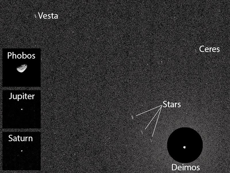
NASA's Curiosity rover captures images of asteroids Ceres and Vesta

For the first time, NASA's Curiosity rover has captured images of an asteroid from the surface of Mars -- two of them, in fact.

The imagery recorded by Curiosity and beamed back to Earth feature Ceres and Vesta, two of the largest asteroids in the asteroid belt that runs between between Mars and Jupiter.

This Curiosity first was also a bit of a coincidence, as the SUV-sized rover had aimed its cameras at the Martian sky in order to snap shots of the Red Planet's two moons, not hunt for asteroids whizzing by.

"This imaging was part of an experiment checking the opacity of the atmosphere at night in Curiosity's location on Mars, where water-ice clouds and hazes develop during this season," camera team member Mark Lemmon, of Texas A&M University, explained in a statement.

"The two Martian moons were the main targets that night, but we chose a time when one of the moons was near Ceres and Vesta in the sky."

Mark Lemmon
NASA is currently on its way to get an even closer look at this two giant space rocks.

NASA's Dawn spacecraft orbited the 350-mile-wide Vesta asteroid in 2011 and 2012, and it is preparing to orbit the 590-mile-wide Ceres in 2015.

Wednesday, April 16, 2014

NASA Mars Curiosity Rover: Rover Near Martian Butte

NASA's Curiosity Mars rover and tracks from its driving are visible in this view from orbit, acquired on April 11, 2014, by the High Resolution Imaging Science Experiment (HiRISE) camera on NASA's Mars Reconnaissance Orbiter.

Image Credit: NASA/JPL-Caltech/Univ. of Arizona

Scientists using NASA's Curiosity Mars rover are eyeing a rock layer surrounding the base of a small butte, called "Mount Remarkable," as a target for investigating with tools on the rover's robotic arm.

The rover works near this butte in an image taken on April 11 by the High Resolution Imaging Science Experiment (HiRISE) camera on NASA's Mars Reconnaissance Orbiter.

A rover's-eye view of Mount Remarkable and surroundings as seen from Curiosity's position in that HiRISE image is available in a mosaic of images from Curiosity's Navigation Camera (Navcam).

The butte stands about 16 feet (5 meters) high. Curiosity's science team refers to the rock layer surrounding the base of Mount Remarkable as the "middle unit" because its location is intermediate between rocks that form buttes in the area and lower-lying rocks that show a pattern of striations.

Depending on what the mission scientists learn from a close-up look at the rock and identification of chemical elements in it, a site on this middle unit may become the third rock that Curiosity samples with its drill.

The rover carries laboratory instruments to analyze rock powder collected by the drill.

The mission's first two drilled samples, in an area called Yellowknife Bay near Curiosity's landing site, yielded evidence last year for an ancient lakebed environment with available energy and ingredients favorable for microbial life.

NASA's Curiosity Mars rover and its tracks are visible in this view combining information from three observations by the High Resolution Imaging Science Experiment (HiRISE) camera on NASA's Mars Reconnaissance Orbiter

The image appears three-dimensional when viewed through red-blue glasses.

Image Credit: NASA/JPL-Caltech/Univ. of Arizona

Wednesday, April 9, 2014

NASA Mars MSL: Gusev Crater once held a lake

The Comanche outcrop, seen in a mosaic of Panoramic Camera images from the Mars rover Spirit, holds key mineralogical evidence for an ancient lake in Gusev Crater. 

Credit: NASA /JPL-Caltech /Cornell University /Arizona State University

If desert mirages occur on Mars, "Lake Gusev" belongs among them. This come-and-go body of ancient water has come and gone more than once, at least in the eyes of Mars scientists.

Now, however, it's finally shifting into sharper focus, thanks to a new analysis of old data by a team led by Steve Ruff, associate research professor at Arizona State University's Mars Space Flight Facility in the School of Earth and Space Exploration.

The team's report was just published in the April 2014 issue of the journal Geology.

The story begins in early 2004, when NASA landed Spirit, one of its two Mars Exploration Rovers, inside 100-mile-wide Gusev Crater. Why Gusev?

Because from orbit, Gusev looked, with its southern rim breached by a meandering river channel, as if it once held a lake – and water-deposited rocks were the rover mission's focus.

Yet when Spirit began to explore, scientists found Gusev's floor was paved not with lakebed sediments, but volcanic rocks.

Less than two miles away however stood the Columbia Hills, 300 feet high. When Spirit drove up into them, it indeed discovered ancient rocks that had been altered by water.

But to scientists' chagrin, no lake sediments were among them. Instead, scientists discovered evidence of hydrothermal activity, essentially hot springs like those in Yellowstone National Park.

But there's hope yet for Lake Gusev, thanks to a Columbia Hills rock outcrop dubbed Comanche. This outcrop is unusually rich in magnesium-iron carbonate minerals, a discovery made in 2010 that Ruff played a major role in making.

While Comanche's carbonate minerals were originally attributed to hydrothermal activity, the team's new analysis points to a different origin.

Cool waters
Says Ruff, "We looked more closely at the composition and geologic setting of Comanche and nearby outcrops."

"There's good evidence that low temperature surface waters introduced the carbonates into Comanche rather than hot water rising from deep down."

Comanche started out as a volcanic ash deposit known as tephra that originally covered the Columbia Hills and adjacent plains. This material, Ruff explains, came from explosive eruptions somewhere within or around Gusev.

Then floodwaters entered the crater through the huge valley that breaches Gusev's southern rim. These floods appear to have ponded long enough to alter the tephra, producing briny solutions.

When the brines evaporated, they left behind residues of carbonate minerals. As the lake filled and dried, perhaps many times in succession, it loaded Comanche and its neighbour rocks with carbonates.

"The lake didn't have to be big," Ruff explains. "The Columbia Hills stand 300 feet high, but they're in the lowest part of Gusev. So a deep, crater-spanning lake wasn't needed."

Today, the Columbia Hills rise as an island of older terrain surrounded by younger lava flows, Ruff says.

"Comanche and a neighbour outcrop called Algonquin are remnants of the older and much more widespread tephra deposit. The wind has eroded most of that deposit, also carrying away much of the evidence for an ancient lake."

Tuesday, April 8, 2014

NASA Curiosity Rover: Next Science Destination - The Kimberley

NASA's Curiosity Mars rover recorded this view of various rock types at waypoint called "the Kimberley" shortly after arriving at the location on April 2, 2014. 

The site offers a diversity of rock types exposed close together in a decipherable geological relationship to each other.

Credit: NASA/JPL-Caltech

NASA's Mars rover Curiosity has reached its next study area and is now scoping out rocks that it will take an up-close look at over the next few weeks.

The Curiosity rover snapped new photos of Mars after driving 98 feet (30 meters) on Wednesday (April 2) and topping a small hill that affords a good view of the surrounding area, which NASA scientists have dubbed "the Kimberley," officials said.

"This is the spot on the map we've been headed for, on a little rise that gives us a great view for context imaging of the outcrops at the Kimberley," Melissa Rice of the California Institute of Technology in Pasadena, the science team lead for Curiosity's work at the site, said in a statement.

This view from NASA's Curiosity Mars rover was taken the day before the rover's final approach drive to "the Kimberley" waypoint, selected months ago as the location for the mission's next major investigations. 

It combines several frames taken by the Navigation Camera on April 1, 2014.

Credit: NASA/JPL-Caltech

Four different types of rock intersect at the Kimberley, providing Curiosity with a wealth of material to study.

The rover is expected to do a great deal of work at the site, conducting its most extensive analyses since leaving a spot called "Yellowknife Bay" last year, NASA officials said.

Curiosity found evidence of an ancient stream-and-lake system at Yellowknife Bay, suggesting that the area could have supported microbial life billions of years ago.

Tuesday, March 25, 2014

NASA Mars Curiosity rover finds sandstone variations

Sandstone layers with varying resistance to erosion are evident in this Martian scene recorded by the Mast Camera on NASA's Curiosity Mars rover on Feb. 25, 2014, about one-quarter mile (about 400 meters) from a planned waypoint called "the Kimberley." 

Credit: NASA /JPL-Caltech /MSSS

Variations in the stuff that cements grains together in sandstone have shaped the landscape surrounding NASA's Curiosity Mars rover and could be a study topic at the mission's next science waypoint.

On a journey with many months yet to go toward prime destinations on the lower slope of Mount Sharp, Curiosity is approaching a site called "the Kimberley."

Scientists on the team picked this location last year as a likely place to pause for investigation.

Its informal name comes from a northwestern Australia region known as the Kimberley. The Martian site's geological appeal, based on images taken from orbit, is that four types of terrain with different rock textures intersect there.

Ashwin Vasavada
"The orbital images didn't tell us what those rocks are, but now that Curiosity is getting closer, we're seeing a preview," said Curiosity Deputy Project Scientist Ashwin Vasavada of NASA's Jet Propulsion Laboratory, Pasadena, Calif.

"The contrasting textures and durabilities of sandstones in this area are fascinating.

While superficially similar, the rocks likely formed and evolved quite differently from each other."

The rocks that the Curiosity mission has studied most intensively so far are finer-grain mudstone, rather than sandstone.

The rover found evidence for an ancient lakebed environment favorable for microbial life when it analyzed sample powder drilled from mudstone last year in an area called "Yellowknife Bay."

The rover team is eager to inspect sandstone at the planned waypoint, now just 282 feet (86 meters) south of the rover.

The pause for investigations at this site might include time for collecting rock-sample material with the rover's drill, for delivery to the laboratory instruments inside the vehicle.