Showing posts with label rock. Show all posts

Wednesday, December 17, 2014

30,000 Diamonds in one rock - Alrosa 's Udachnaya diamond mine

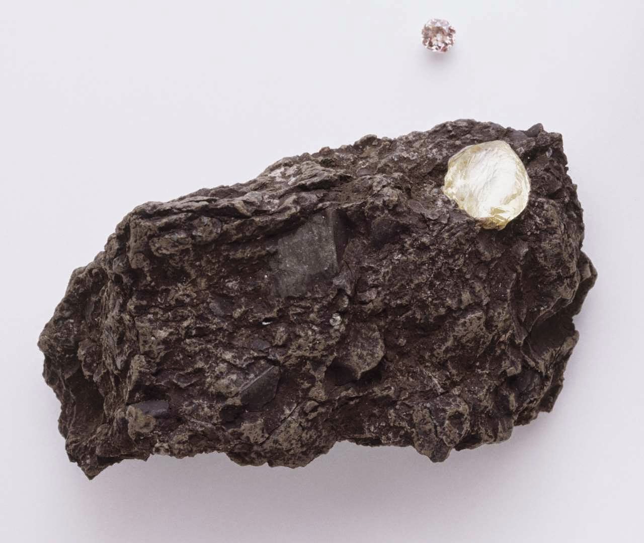
Strange rock containing 30,000 diamonds baffles science and the geologists.

Credit: Getty Images

When Russian miners pulled a strange red and green stone out of the ground, they immediately knew it was different to the thousands of tons of ore they process every day.

In fact, what workers at Alrosa 's Udachnaya diamond mine had unearthed was a 30mm rock that contained 30,000 diamonds, a concentration 1M times higher than normal.

However, despite the rare find the company donated the rock to the Russian Academy of Sciences, as the diamonds are so small that they cannot be used as gems.

After scanning the rock with X-rays, scientists found that the diamonds inside measure just 1mm and are octahedral in shape - similar to two pyramids stuck together at the base.

The red and green colouring comes from larger crystals of garnet, olivine and pyroxene.

"The exciting thing for me is there are 30,000 itty-bitty, perfect octahedrons, and not one big diamond," said Larry Taylor, a geologist at the University of Tennessee, who presented the findings at the American Geophysical Union 's annual meeting.

"It's like they formed instantaneously. This rock is a strange one indeed."

Scientists are excited at the finding as they hope it will shed further light on how diamonds are made.

They know diamonds are crystals of pure carbon that form under crushing pressures and intense heat, mostly formed in the Earth's mantle, the layer beneath the crust or surface layer, at a depth of about 150km. However, certain processes in their creation remain a mystery.

"The [chemical] reactions in which diamonds occur still remain an enigma," Mr Taylor told Live Science, which first reported the story.

Mr Taylor works with researchers at the Russian Academy of Sciences to study Udachnaya diamonds.

Russia is the largest diamond-producing country in the world, and produced more than 33m carats last year.

State-controlled Alrosa is the world's leading diamond miner, accounting for 99pc of Russia’s output and 27pc of global production. Its sees rough diamond revenues of more than $4bn a year.

Last week Alrosa signed a dozen deals with Indian buyers to increase direct deliveries to Asia's third-largest economy.

The firm earns half of its revenue, or around $2.5bn, from Indian-funded clients, and the deal could help Russia reduce risks linked to Western sanctions imposed over its role in the Ukraine crisis.

Last month Alrosa revealed a 10.5bn rouble (£110m) loss for its third quarter despite sales rising 7.6pc.

The Udachnaya mine, in the Sakha Republic, just outside the Arctic circle, is more than 600 metres deep, making it the third deepest open-pit mine in the world.

Friday, September 26, 2014

NASA Mars Rover Curiosity: Drill Pulls First Taste From Mars Mountain

This image from the Mars Hand Lens Imager (MAHLI) camera on NASA's Curiosity Mars rover shows the first sample-collection hole drilled in Mount Sharp, the layered mountain that is the science destination of the rover's extended mission.

Image Credit: NASA/JPL-Caltech/MSSS

NASA's Curiosity Mars rover has collected its first taste of the layered mountain whose scientific allure drew the mission to choose this part of Mars as a landing site.

Late Wednesday, Sept. 24, the rover's hammering drill chewed about 2.6 inches (6.7 centimeters) deep into a basal-layer outcrop on Mount Sharp and collected a powdered-rock sample.

Data and images received early Thursday at NASA's Jet Propulsion Laboratory, Pasadena, California, confirmed success of this operation.

The powder collected by the drilling is temporarily held within the sample-handling mechanism on the rover's arm.

"This drilling target is at the lowest part of the base layer of the mountain, and from here we plan to examine the higher, younger layers exposed in the nearby hills," said Curiosity Deputy Project Scientist Ashwin Vasavada of JPL.

"This first look at rocks we believe to underlie Mount Sharp is exciting because it will begin to form a picture of the environment at the time the mountain formed, and what led to its growth."


This southeastward-looking vista from the Mast Camera (Mastcam) on NASA's Curiosity Mars rover shows the "Pahrump Hills" outcrop and surrounding terrain seen from a position about 70 feet (20 meters) northwest of the outcrop.

Image Credit: NASA/JPL-Caltech/MSSS

Curiosity arrived Sept. 19 at an outcrop called "Pahrump Hills," which is a section of the mountain's basal geological unit, called the Murray formation.

Three days later, the rover completed a "mini-drill" procedure at the selected drilling target, "Confidence Hills," to assess the target rock's suitability for drilling.

A mini-drill activity last month determined that a rock slab under consideration then was not stable enough for full drilling, but Confidence Hills passed this test.

This image from the Mars Hand Lens Imager (MAHLI) camera on NASA's Curiosity Mars rover shows an example of a type of geometrically distinctive feature that researchers are using Curiosity to examine at a mudstone outcrop at the base of Mount Sharp.

Image Credit: NASA/JPL-Caltech/MSSS

The rock is softer than any of the previous three targets where Curiosity has collected a drilled sample for analysis.

Between the mini-drill test and the sample-collection drilling, researchers used tools on Curiosity's mast and robotic arm for close-up inspection of geometrically distinctive features on the nearby surface of the rock.

These features on the Murray formation mudstones are the accumulations of resistant materials. They occur both as discrete clusters and as dendrites, where forms are arranged in tree-like branching.

By investigating the shapes and chemical ingredients in these features, the team hopes to gain information about the possible composition of fluids at this Martian location long ago.

Read the full article here

Monday, September 8, 2014

Meteorite impact: Nicaragua government report - Video


"A mysterious explosion that rocked Nicaragua's crowded capital Managua, creating a large crater, appears to have been caused by a meteorite, officials said Sunday.

Amazingly, in a sprawling city of 1.2 million people, the impact near the international airport did not cause any known injuries, but it did leave a crater measuring 12 meters (39 feet) across.

"We are convinced that this was a meteorite. We have seen the crater from the impact," said Wilfredo Strauss of the Seismic Institute.

The meteorite appeared to have hurtled into a wooded area near the airport around midnight Saturday, its thunderous impact felt across the capital.

The hit was so large that it registered on the instruments Strauss's organization uses to size up earthquakes."

In this Sunday Sept. 7, 2014, publicly distributed handout photo provided by the Nicaraguan Army shows an impact crater made by a small meteorite in a wooded area near Managua's international airport and an air force base. 

Nicaraguan government spokeswoman Rosario Murillo said Sunday that a loud boom heard overnight by residents of the capital was a "relatively small" meteorite that "appears to have come off an asteroid that was passing close to Earth." 

Credit: AP Photo/Nicaraguan Army

Nicaragua's government said Sunday that a mysterious boom heard overnight in the capital was made by a small meteorite that left a crater in a wooded area near Managua's airport.

Government spokeswoman Rosario Murillo said a committee formed by the government to study the event determined it was a "relatively small" meteorite that "appears to have come off an asteroid that was passing close to Earth."

Murillo said Nicaragua will ask international experts to help local scientists in understanding what happened.

The crater left by the meteorite had a radius of 12 meters (39 feet) and a depth of 5 meters (16 feet), said Humberto Saballos, a volcanologist with the Nicaraguan Institute of Territorial Studies who was on the committee. He said it is still not clear if the meteorite disintegrated or was buried.

Humberto Garcia, of the Astronomy Center at the National Autonomous University of Nicaragua, said the meteorite could be related to an asteroid that was forecast to pass by the planet Saturday night.

"We have to study it more because it could be ice or rock," he said.

Wilfried Strauch, an adviser to the Institute of Territorial Studies, said it was "very strange that no one reported a streak of light. We have to ask if anyone has a photo or something."

Local residents reported hearing a loud boom Saturday night, but said they didn't see anything strange in the sky.

"I was sitting on my porch and I saw nothing, then all of a sudden I heard a large blast. We thought it was a bomb because we felt an expansive wave," Jorge Santamaria told The Associated Press.

The site of the crater is near Managua's international airport and an air force base. Only journalists from state media were allowed to visit it.

Sunday, July 20, 2014

NASA Mars Curiosity Rover: ChemCam Laser makes Sparks Fly - Video


NASA's Curiosity rover on Mars has set off some fireworks on the Red Planet with the zap-zap-zap of its high-tech space laser.

On Saturday (July 12), Curiosity photographed sparks flying from a baseball-size rock blasted by the 1-ton robot's laser-sampling Chemistry and Camera instrument (ChemCam).

You can see the laser flashes in this new video of Curiosity's work from NASA, which compiles pictures taken by the Mars Hand Lens Imager (MAHLI) camera on the rover's arm.

While Curiosity has fired its laser at more than 600 different targets since touching down on Mars in August 2012, the rover had never captured images of the resulting sparks before Saturday, NASA officials said.

NASA's Curiosity Mars rover used the Mars Hand Lens Imager (MAHLI) camera on its arm to catch the first images of sparks produced by the rover's laser being shot at a rock on Mars.

NASA's Curiosity Mars rover used the Mars Hand Lens Imager (MAHLI) camera on its arm to catch the first images of sparks produced by the rover's laser being shot at a rock on Mars. 

Credit: NASA

"This is so exciting! The ChemCam laser has fired more than 150,000 times on Mars, but this is the first time we see the plasma plume that is created," ChemCam deputy principal investigator Sylvestre Maurice, of France's National Center for Scientific Research and the University of Toulouse, said in a NASA statement.

"Each time the laser hits a target, the plasma light is caught and analyzed by ChemCam's spectrometers," Maurice added. "What the new images add is confirmation that the size and shape of the spark are what we anticipated under Martian conditions."

The rock, which rover team members named "Nova," sports a layer of dust and is rich in aluminum, silicon and sodium, researchers said. Its composition is similar to other stones Curiosity has zapped recently.

Sunday, April 27, 2014

Shipping Alert: Underwater volcano creates huge floating islands of rock

Havre pumice raft drifting in the Pacific. The scale bar is 20km. 

Credit: Nature Communications

A team of scientists from the UK, the US, Australia and New Zealand have modelled the fate of a huge floating raft of volcanic rocks that formed in 2012 during a submarine eruption of a Pacific volcano.

Described in this month's edition of Nature Communications, they show how satellite images of the floating-rock raft's passage across the Pacific can be used to test models of ocean circulation.

Their results could be used to forecast the dispersal of future pumice (volcanic rock) islands, and protect shipping from the hazards they pose.

The eruptions of the Icelandic volcano, Eyjafjallajökull, in 2010 brought the hazards associated with volcanic ash sharply into focus.

Air routes across northern Europe were disrupted, leaving many passengers stranded and far from home for days on end.

Ocean hazard
Hazards of floating islands of pumice spewed into the ocean from erupting volcanoes, are less well-known as a shipping hazard.

One such island grew from an explosion of the Havre volcano (seamount) in the South Pacific, between Tonga and New Zealand, in July 2012.

The volcano threw out a cubic kilometre of molten magma, which suddenly froze to form bubble-filled pumice.

Floating pumice. 

Credit: Jeff Butterworth

It is the bubbles trapped in pumice that make it so light, half the density of water, so the rock floats on water.

Like natural flotsam, pebble to boulder-sized lumps of pumice clump together.

This can create huge floating rafts in the seas around erupting volcanoes, and they can be tens of centimetres thick but thousands of kilometres in length.

Records of the use of pumice exist since the time of the Romans and Ancient Greeks. Its rough texture made them effective abrasives to remove dead skin from calluses and corns.

However, now, such floating pumice can pose a hazard for shipping. Hulls can be damaged by abrasion from the hard but light pumice, and when it approaches land these pumice rafts can block harbours and disrupt navigation.

Havre's pumice island affected an area of ocean twice as big as both islands of New Zealand put together, floating atop the sea.

Boats entering the volcanic debris reported engine problems, as the rock and dust clogged their water cooling intakes.

The study, led by Martin Jutzeler at the National Oceanography Centre in Southampton, UK, shows how the rafts eventually break up into ribbons of rock that can cover a wide area.

The simulation techniques that the team has developed will allow the progress of future volcanic rafts to be predicted, and warnings issued to shipping, in the same way as volcanic ash clouds can be forecast for aircraft approaching stratospheric eruptions.

Read the full article here

Tuesday, April 15, 2014

Pluto: Three possible models of Dwarf Planet ahead of New Horizons visit

Interior structure models assumed for Pluto.

Two space researchers, Amy Barr, with Brown University and Geoffrey Collins with Wheaton College, have published a paper in the journal Icarus in which they describe three possible interior models of the former planet Pluto.

They suggest the possibilities include: 
  1. an undifferentiated rock/ice mixture, 
  2. a differentiated rock/ice mixture, and an ocean covered with ice. 
  3. The third possibility suggests the likelihood, they claim, of tectonic action on the dwarf planet.

Pluto
A close up view of the planet by space probe New Horizons due to arrive next year, should help clarify which scenario is most likely.

Amy Barr
Scientists believe that Pluto came to exist as it does today, in part due to a collision billions of years ago that led also to the formation of its moon Charon.

Charon
When celestial bodies collide, not only do they knock each other around, they produce heat—heat, the researchers suggest that could still be evident today.

Barr and Collins are leading towards a theory that suggests that shortly after impact, Pluto and Charon were much closer together, the gravity attraction between them would have caused both to be egg shaped.

As time passed, melted ice from the impact would have created an icy crust on top of an ocean on Pluto, and then, as Charon moved farther away, the attractive pull would have diminished, causing ice plates to form and crack against one another, a form of tectonics.

Geoffrey Collins
If that were the case, the two add, then in all likelihood, when New Horizons begins sending back images, they should see evidence of such tectonic action—plate edges thrust into the air, for example.

There's just one catch, Pluto circles the sun in an elliptical orbit, thus sometimes it's much closer to the sun than other times.

When near, it has a defined atmosphere, when far away however, its atmosphere actually freezes to its surface, something that could hide ridges in the ice and thus evidence of both tectonic activity and an ocean beneath the crust of ice.

New Horizons
Artist concept of New Horizons spacecraft.

Johns Hopkins University Applied Physics Laboratory (JHUAPL) 
/Southwest Research Institute (SwRI)

Since New Horizons will arrive during a time when its atmosphere is frozen to the surface, it might be difficult to determine which of the three proposed models actually describes the relationship between its exterior and interior.

Barr and Collins are optimistic that even in such a scenario, ridges should be apparent, proving that beneath Pluto's icy surface, lies an ocean, one that future researchers might one day sample.

More information: Tectonic Activity on Pluto After the Charon-Forming Impact, Icarus, Available online 4 April 2014. dx.doi.org/10.1016/j.icarus.2014.03.042 . Available on Arxiv: xxx.lanl.gov/abs/1403.6377

Wednesday, January 29, 2014

The Grand Tack model: 'Rogue' asteroids may be normal

Credit: NASA/JPL-Caltech

To get an idea of how the early solar system may have formed, scientists often look to asteroids.

These relics of rock and dust represent what today's planets may have been before they differentiated into bodies of core, mantle, and crust.

In the 1980s, scientists' view of the solar system's asteroids was essentially static: Asteroids that formed near the sun remained near the sun; those that formed farther out stayed on the outskirts.

But in the last decade, astronomers have detected asteroids with compositions unexpected for their locations in space: Those that looked like they formed in warmer environments were found further out in the solar system, and vice versa. Scientists considered these objects to be anomalous "rogue" asteroids.

But now, a new map developed by researchers from MIT and the Paris Observatory charts the size, composition, and location of more than 100,000 asteroids throughout the solar system, and shows that rogue asteroids are actually more common than previously thought.

Particularly in the solar system's main asteroid belt—between Mars and Jupiter—the researchers found a compositionally diverse mix of asteroids.

The new asteroid map suggests that the early solar system may have undergone dramatic changes before the planets assumed their current alignment.

For instance, Jupiter may have drifted closer to the sun, dragging with it a host of asteroids that originally formed in the colder edges of the solar system, before moving back out to its current position.

Jupiter's migration may have simultaneously knocked around more close-in asteroids, scattering them outward.

Francesca DeMeo
"It's like Jupiter bowled a strike through the asteroid belt," says Francesca DeMeo, who did much of the mapping as a postdoc in MIT's Department of Earth, Atmospheric and Planetary Sciences.

"Everything that was there moves, so you have this melting pot of material coming from all over the solar system."

DeMeo says the new map will help theorists flesh out such theories of how the solar system evolved early in its history.

She and Benoit Carry of the Paris Observatory have published details of the map in Nature.

The compositional diversity seen in this new asteroid map may add weight to a theory of planetary migration called the Grand Tack model.

This model lays out a scenario in which Jupiter, within the first few million years of the solar system's creation, migrated as close to the sun as Mars is today.

During its migration, Jupiter may have moved right through the asteroid belt, scattering its contents and repopulating it with asteroids from both the inner and outer solar system before moving back out to its current position—a picture that is very different from the traditional, static view of a solar system that formed and stayed essentially in place for the past 4.5 billion years.

"That [theory] has been completely turned on its head," DeMeo says. "Today we think the absolute opposite: Everything's been moved around a lot and the solar system has been very dynamic."

DeMeo adds that the early pinballing of asteroids around the solar system may have had big impacts on Earth.

For instance, colder asteroids that formed further out likely contained ice. When they were brought closer in by planetary migrations, they may have collided with Earth, leaving remnants of ice that eventually melted into water.

"The story of what the asteroid belt is telling us also relates to how Earth developed water, and how it stayed in this Goldilocks region of habitability today," DeMeo says.

More information: Paper: dx.doi.org/10.1038/nature12908

Monday, August 5, 2013

The Lazarus Comets: Asteroid Belt a Graveyard for Comets

These illustrations show the asteroid belt in the present day and in the early Solar System, located between the Sun (at centre) and four terrestrial planets (near the Sun) and Jupiter (at bottom left). 

The top image shows the conventional model for the asteroid belt; largely composed of rocky material. 

The middle image shows the proposed model, with a small number of active comets and a dormant cometary population. 

The lower diagram shows how the asteroid belt might have looked in the early Solar System, with vigorous cometary activity. 

Credit: Ignacio Ferrin / University of Anitoquia

A team of astronomers from the University of Anitoquia, Medellin, Colombia, have discovered a graveyard of comets.

The researchers, led by Anitoquia astronomer Prof. Ignacio Ferrin, describe how some of these objects, inactive for millions of years, have returned to life leading them to name the group the 'Lazarus comets'.

The team publish their results in the Oxford University Press journal Monthly Notices of the Royal Astronomical Society.

Comets are among the smallest objects in the Solar System, typically a few km across and composed of a mixture of rock and ices.

Ignacio Ferrin
If they come close to the Sun, then some of the ices turn to gas, before being swept back by the light of the Sun and the solar wind to form a characteristic tail of gas and dust.

Most observed comets have highly elliptical orbits, meaning that they only rarely approach the Sun. Some of these so-called long period comets take thousands of years to complete each orbit around our nearest star.

There is also a population of about 500 short period comets, created when long period comets pass near Jupiter and are deflected in orbits that last anything between 3 and 200 years.

Although uncommon events, comets also collide with Earth from time to time and may have helped bring water to our planet.

The new work looked at a third and distinct region of the Solar System, the main belt of asteroids between the orbits of Mars and Jupiter.

This volume of space contains more than 1 million objects ranging in size from 1 m to 800 km.

The traditional explanation for asteroids is that they are the building blocks of a planet that never formed, as the movement of the pieces was disrupted by the strong gravitational field of Jupiter.

In the last decade 12 active comets have been discovered in the asteroid main belt region. This was something of a surprise and the Medellin team set out to investigate their origin.

Jorge Zuluaga
The team, made up of Prof. Ferrin and his colleagues Profs. Jorge Zuluaga and Pablo Cuartas, now think they have an explanation.

"We found a graveyard of comets," exclaims Professor Ferrín. He adds: "Imagine all these asteroids going around the Sun for aeons, with no hint of activity. We have found that some of these are not dead rocks after all, but are dormant comets that may yet come back to life if the energy that they receive from the Sun increases by a few per cent."

Surprisingly, this can happy fairly easily, as the orbits of many objects in the asteroid belt are nudged by the gravity of Jupiter. The shape of their orbits can then change, leading to a decrease in the minimum distance between the object and the Sun (perihelion) and a slight increase in average temperature.

Pablo Cuartas
According to this interpretation, millions of years ago the main belt was populated by thousands of active comets.

This population aged and the activity subsided. What we see today is the residual activity of that glorious past.

Twelve of those rocks are true comets that were rejuvenated after their minimum distance from the Sun was reduced a little.

The little extra energy they received from the Sun was then sufficient to revive them from the graveyard.

Prof. Ferrin describes the 12 active comets. "These objects are the 'Lazarus comets', returning to life after being dormant for thousands or even millions of years. Potentially any one of the many thousands of their quiet neighbours could do the same thing."

Journal Reference:
Ignacio Ferrin, Jorge Zuluaga, Pablo Cuartas. The location of Asteroidal Belt Comets (ABCs), in a comets' evolutionary diagram: The Lazarus Comets. Monthly Notices of the Royal Astronomical Society., 2013

Saturday, May 18, 2013

NASA Mars Rover Opportunity examines clay clues in rock Esperance

The pale rock in the upper center of this image, about the size of a human forearm, includes a target called "Esperance," which was inspected by NASA's Mars Exploration Rover Opportunity.

Data from the rover's Alpha Particle X-ray Spectrometer (APXS) indicate that Esperance's composition is higher in aluminum and silica, and lower in calcium and iron, than other rocks Opportunity has examined in more than nine years on Mars.

Preliminary interpretation points to clay mineral content due to intensive alteration by water. 

Image Credit: NASA/JPL-Caltech/Cornell/Arizona State Univ.

NASA's senior Mars rover, Opportunity, is driving to a new study area after a dramatic finish to 20 months on "Cape York" with examination of a rock intensely altered by water.

The fractured rock, called "Esperance," provides evidence about a wet ancient environment possibly favorable for life.

Steve Squyres
The mission's principal investigator, Steve Squyres of Cornell University, Ithaca, N.Y., said, "Esperance was so important, we committed several weeks to getting this one measurement of it, even though we knew the clock was ticking."

The mission's engineers at NASA's Jet Propulsion Laboratory, Pasadena, Calif., had set this week as a deadline for starting a drive toward "Solander Point," where the team plans to keep Opportunity working during its next Martian winter.

"What's so special about Esperance is that there was enough water not only for reactions that produced clay minerals, but also enough to flush out ions set loose by those reactions, so that Opportunity can clearly see the alteration," said Scott McLennan of the State University of New York, Stony Brook, a long-term planner for Opportunity's science team.

This map of a portion of the western rim of Endeavour Crater on Mars shows the area where NASA's Mars Exploration Rover Opportunity worked for 20 months, "Cape York," in relation to the area where the rover team plans for Opportunity to spend its sixth Martian winter, "Solander Point."

This rock's composition is unlike any other Opportunity has investigated during nine years on Mars—higher in aluminum and silica, lower in calcium and iron.

The next destination, Solander Point, and the area Opportunity is leaving, Cape York, both are segments of the rim of Endeavour Crater, which spans 14 miles (22 kilometers) across.

The planned driving route to Solander Point is about 1.4 miles (2.2 kilometers).

Cape York has been Opportunity's home since the rover arrived at the western edge of Endeavour in mid-2011 after a two-year trek from a smaller crater.

"Based on our current solar-array dust models, we intend to reach an area of 15 degrees northerly tilt before Opportunity's sixth Martian winter," said JPL's Scott Lever, mission manager.

Scott McLennan
"Solander Point gives us that tilt and may allow us to move around quite a bit for winter science observations."

Northerly tilt increases output from the rover's solar panels during southern-hemisphere winter.

Daily sunshine for Opportunity will reach winter minimum in February 2014. The rover needs to be on a favourable slope well before then.

This mosaic of four frames shot by the microscopic imager on the robotic arm of NASA's Mars Exploration Rover Opportunity shows a rock target called "Esperance" after some of the rock's surface had been removed by Opportunity's rock abrasion tool, or RAT. 

Credit: NASA/JPL-Caltech /Cornell /USGS

The first drive away from Esperance covered 81.7 feet (24.9 meters) on May 14.

Three days earlier, Opportunity finished exposing a patch of the rock's interior with the rock abrasion tool.

The team used a camera and spectrometer on the robotic arm to examine Esperance.

JPL's Scott Lever, mission manager
The team identified Esperance while exploring a portion of Cape York where the Compact Reconnaissance Spectrometer for Mars (CRISM) on NASA's Mars Reconnaissance Orbiter (MRO) had detected a clay mineral.

Clays typically form in wet environments that are not harshly acidic.

For years, Opportunity had been finding evidence for ancient wet environments that were very acidic.

The CRISM findings prompted the rover team to investigate the area where clay had been detected from orbit.

There, they found an outcrop called "Whitewater Lake," containing a small amount of clay from alteration by exposure to water.

"There appears to have been extensive, but weak, alteration of Whitewater Lake, but intense alteration of Esperance along fractures that provided conduits for fluid flow," Squyres said.

"Water that moved through fractures during this rock's history would have provided more favourable conditions for biology than any other wet environment recorded in rocks Opportunity has seen."

Monday, April 8, 2013

Mineral analysis of Copernicus lunar crater deposit - Melted rock

Pre-existing mineral deposits on the Moon (sinuous melt, above) survived impacts powerful enough to melt rock. 

Visible only in certain wavelengths, the deposits are not detectable in the crater image (inset). Large impacts on the Moon can form wide craters and turn surface rock liquid.

Geophysicists once assumed that liquid rock would be homogenous when it cooled. Now researchers have found evidence that pre-existing mineralogy can survive impact melt.

Despite the unimaginable energy produced during large impacts on the Moon, those impacts may not wipe the mineralogical slate clean, according to new research led by Brown University geoscientists.

The researchers have discovered a rock body with a distinct mineralogy snaking for 18 miles across the floor of Copernicus crater, a 60-mile-wide hole on the Moon's near side.

The sinuous feature appears to bear the mineralogical signature of rocks that were present before the impact that made the crater.

The deposit is interesting because it is part of a sheet of impact melt, the cooled remains of rocks melted during an impact.

The assumption was that the impact energy would the elemental composition thoroughly during the liquid phase, mixing all the rock types together into an indistinguishable mass.

Identifying any pre-impact mineral variation would be impossible but this distinct feature found at Copernicus suggests that pre-existing mineralogy isn't always blended away by the impact process.

Deepak Dhingra
"The indications are that impact melt deposits aren't bland," said Deepak Dhingra, a Brown graduate student who led the research.

"The implication is that we don't understand the impact cratering process quite as well as we thought."

The findings are published in online early view in the journal Geophysical Research Letters.

Reference
"Mineral analysis of lunar crater deposit prompts a second look at the impact cratering process": doi/10.1002/grl.50255/abstract

Read more of this article at Phys.org

Friday, October 12, 2012

NASA Mars Rover Curiosity Image: Rock named 'Jake Matijevic' Holds Surprises

This image shows where NASA's Curiosity rover aimed two different instruments to study a rock known as "Jake Matijevic" in late September 2012. 

The red dots indicate where Curiosity fired its laser at the rock. 

The circular black and white images are ChemCam images to examine the laser burns. 

Purple circles show spots where Curiosity used its Alpha Particle X-ray Spectrometer (APXS) to study the rock.

CREDIT: NASA/JPL-Caltech/MSSS

Saturday, June 18, 2011

Fabulous Picture of 'strange looking rocks'

After months of anticipation and exhausting preparations and planning for taking photos of the total lunar eclipse, everything went wrong due to a severe thunderstorm during the phenomenon.

Everything? Well...fortunatelly no, because for approximately 10 minutes in the middle of totality, a small window in the sky allowed me to see the Moon in the Earth's shadow and shoot this unbelievable photo.

The shot was taken from Ikaria island at Pezi, an area known as "the planet of the goats", because of the rough terrain with the strange looking rocks

Friday, March 26, 2010

NASA Mars: Rover Opportunity Image of Chocolate Hills rock

Picture: AFP / NASA / JPL

The Chocolate Hills rock on Mars. NASA's Mars Exploration Rover Opportunity took the image showing a strange coating that one researcher has called a "blueberry sandwich."

The coating appears blue because of the false-colour effect used to highlight details

Image Credit: NASA/JPL-Caltech/Cornell University

Opportunity's microscopic imager took this detail view of the coating on "Chocolate Hills," on which a layer of peppercorn-size spheres nicknamed "blueberries" are packed densely.