Showing posts with label Geologists. Show all posts

Wednesday, February 11, 2015

Geologists unlock mysteries of our Earth's inner core

A research team from the University of Illinois and colleagues in China found earth's inner core has an inner core of its own, with crystals aligned in a different direction. 

Image courtesy Lachina Publishing Services.

Seismic waves are helping scientists to plumb the world's deepest mystery: the planet's inner core.

Thanks to a novel application of earthquake-reading technology, a research team at the University of Illinois and colleagues at Nanjing University in China have found that the Earth's inner core has an inner core of its own, which has surprising properties that could reveal information about our planet.

Xiaodong Song
Led by Xiaodong Song, a professor of geology at the U. of I., and visiting postdoctoral researcher Tao Wang, the team published its work in the journal Nature Geoscience on Feb. 9.

"Even though the inner core is small - smaller than the moon - it has some really interesting features," said Song.

"It may tell us about how our planet formed, its history, and other dynamic processes of the Earth. It shapes our understanding of what's going on deep inside the Earth."

Researchers use seismic waves from earthquakes to scan below the planet's surface, much like doctors use ultrasound to see inside patients.

The team used a technology that gathers data not from the initial shock of an earthquake, but from the waves that resonate in the earthquake's aftermath.

The earthquake is like a hammer striking a bell; much like a listener hears the clear tone that resonates after the bell strike, seismic sensors collect a coherent signal in the earthquake's coda.

(NB: CODA, on a recorded earthquake seismogram refers to the total length of the seismic wavetrain)

"It turns out the coherent signal enhanced by the technology is clearer than the ring itself," said Song.

"The basic idea of the method has been around for a while, and people have used it for other kinds of studies near the surface, but we are looking all the way through the center of the Earth."

Looking through the core revealed a surprise at the center of the planet, though not of the type envisioned by novelist Jules Verne.

The inner core, once thought to be a solid ball of iron, has some complex structural properties. 

The team found a distinct inner-inner core, about half the diameter of the whole inner core. 

The iron crystals in the outer layer of the inner core are aligned directionally, north-south. However, in the inner-inner core, the iron crystals point roughly east-west.

Not only are the iron crystals in the inner-inner core aligned differently, they behave differently from their counterparts in the outer-inner core.

This means that the inner-inner core could be made of a different type of crystal, or a different phase.

"The fact that we have two regions that are distinctly different may tell us something about how the inner core has been evolving," Song said.

"For example, over the history of the Earth, the inner core might have had a very dramatic change in its deformation regime. It might hold the key to how the planet has evolved. We are right in the center, literally, the center of the Earth."

Wednesday, December 17, 2014

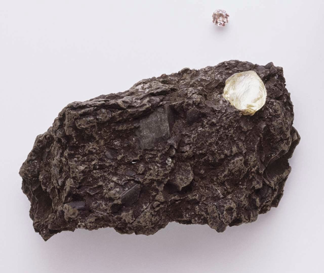
30,000 Diamonds in one rock - Alrosa 's Udachnaya diamond mine

Strange rock containing 30,000 diamonds baffles science and the geologists.

Credit: Getty Images

When Russian miners pulled a strange red and green stone out of the ground, they immediately knew it was different to the thousands of tons of ore they process every day.

In fact, what workers at Alrosa 's Udachnaya diamond mine had unearthed was a 30mm rock that contained 30,000 diamonds, a concentration 1M times higher than normal.

However, despite the rare find the company donated the rock to the Russian Academy of Sciences, as the diamonds are so small that they cannot be used as gems.

After scanning the rock with X-rays, scientists found that the diamonds inside measure just 1mm and are octahedral in shape - similar to two pyramids stuck together at the base.

The red and green colouring comes from larger crystals of garnet, olivine and pyroxene.

"The exciting thing for me is there are 30,000 itty-bitty, perfect octahedrons, and not one big diamond," said Larry Taylor, a geologist at the University of Tennessee, who presented the findings at the American Geophysical Union 's annual meeting.

"It's like they formed instantaneously. This rock is a strange one indeed."

Scientists are excited at the finding as they hope it will shed further light on how diamonds are made.

They know diamonds are crystals of pure carbon that form under crushing pressures and intense heat, mostly formed in the Earth's mantle, the layer beneath the crust or surface layer, at a depth of about 150km. However, certain processes in their creation remain a mystery.

"The [chemical] reactions in which diamonds occur still remain an enigma," Mr Taylor told Live Science, which first reported the story.

Mr Taylor works with researchers at the Russian Academy of Sciences to study Udachnaya diamonds.

Russia is the largest diamond-producing country in the world, and produced more than 33m carats last year.

State-controlled Alrosa is the world's leading diamond miner, accounting for 99pc of Russia’s output and 27pc of global production. Its sees rough diamond revenues of more than $4bn a year.

Last week Alrosa signed a dozen deals with Indian buyers to increase direct deliveries to Asia's third-largest economy.

The firm earns half of its revenue, or around $2.5bn, from Indian-funded clients, and the deal could help Russia reduce risks linked to Western sanctions imposed over its role in the Ukraine crisis.

Last month Alrosa revealed a 10.5bn rouble (£110m) loss for its third quarter despite sales rising 7.6pc.

The Udachnaya mine, in the Sakha Republic, just outside the Arctic circle, is more than 600 metres deep, making it the third deepest open-pit mine in the world.

Thursday, August 21, 2014

Geologists warning of mega Earthquake for Iquique North Chile

North Chile is at risk of a mega earthquake after a tremor in April released only some of the tension building along a high-risk fault zone since 1877, researchers said Wednesday.

Two studies published in the journal Nature said the 8.1-8.2 magnitude quake that shook the city of Iquique, killing six people and forcing a million to leave their homes, may not have been the anticipated Big One.

Scientists have long kept an eye on the north Chile subduction zone, where a slab of the Earth's crust is driving under the South American continent at an average rate of about seven centimetres per year.

Subduction zones are known for yielding powerful quakes.

In 1877, a tremor with an exponentially much higher 8.6-8.8 magnitude ruptured nearly 500 kilometres of the north Chilean fault.

The April 1 Iquique rattler, followed by a strong aftershock, broke only a section of the so-called seismic gap; a section of an active fault that had not ruptured in a long time, building up stress to be released as a major quake.

Gavin Hayes
"Our results... indicate that this (Iquique) was not the earthquake that had been anticipated," wrote the authors of the first study led by Gavin Hayes of the United States Geological Survey.

The study "Continuing Megathrust Earthquake potential in Chile after the Iquique Earthquake" is published in the journal Nature.

"Significant sections of the northern Chile subduction zone have not ruptured in almost 150 years, so it is likely that future megathrust earthquakes will occur to the south and potentially to the north of the 2014 Iquique sequence."

Megathrust earthquakes are often followed by killer tsunamis.

"Observations suggest that enough strain has accumulated along this plate boundary segment to host an earthquake close to M9 (magnitude 9)," the team cautioned.

The authors of the second study said the Iquique quake broke about a third of the northern Chile seismic gap, and agreed that "the remaining locked segments now pose a significant increased seismic hazard."

They put the potential magnitude of such a quake at 8.5.

The second study "Gradual unlocking of plate boundary controlled initiation of the 2014 Iquique earthquake" is also available in the journal Nature.

The corresponding author of this study is Bernd Schurr of GFZ Potsdam.

"The Big One may still be to come," added University of California geologist Roland Burgmann, who wrote a comment on the studies.

Hayes and his team said that on the basis of their findings, "Chilean and global seismologists now face the difficult task of communicating this uncertain yet perhaps elevated hazard, without appearing alarmist."

Chile is one of the most seismically active countries in the world.

Wednesday, April 16, 2014

Earth Observation: Grand Canyon Geology Lessons on View

The Grand Canyon in northern Arizona is a favorite for astronauts shooting photos from the International Space Station, as well as one of the best-known tourist attractions in the world. 

The steep walls of the Colorado River canyon and its many side canyons make an intricate landscape that contrasts with the dark green, forested plateau to the north and south.

The Colorado River has done all the erosional work of carving away cubic kilometers of rock in a geologically short period of time.

Visible as a darker line snaking along the bottom of the canyon, the river lies at an altitude of 715 meters (2,345 feet), thousands of meters below the North and South Rims.

Temperatures are furnace-like on the river banks in the summer, but Grand Canyon Village, the classic outlook point for visitors, enjoys a milder climate at an altitude of 2,100 meters (6,890 feet).

The Grand Canyon has become a geologic icon—a place where you can almost sense the invisible tectonic forces within the Earth.

The North and South Rims are part of the Kaibab Plateau, a gentle tectonic swell in the landscape. The uplift of the plateau had two pronounced effects on the landscape that show up in this image.

First, in drier parts of the world, forests usually indicate higher places; higher altitudes are cooler and wetter, conditions that allow trees to grow.

The other geologic lesson on view is the canyon itself. Geologists now know that a river can cut a canyon only if the Earth surface rises vertically.

If such uplift is not rapid, a river can maintain its course by eroding huge quantities of rock and forming a canyon.

Image Credit: NASA