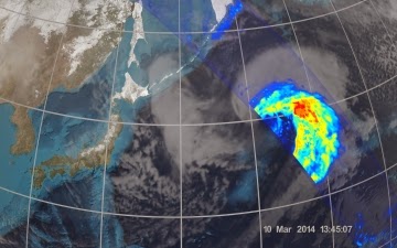
NASA and the Japan Aerospace Exploration Agency (JAXA) have released the first images captured by their newest Earth-observing satellite, the Global Precipitation Measurement (GPM) Core Observatory, which launched into space Feb. 27.
The images show precipitation falling inside a March 10 cyclone over the northwest Pacific Ocean, approximately 1,000 miles east of Japan.
On March 10, the Core Observatory passed over an extra-tropical cyclone about 1,055 miles (1,700 kilometers) due east of Japan's Honshu Island. Satellite data shows the full range of precipitation in the storm.
Image Credit: NASA's Goddard Space Flight Center


No comments:
Post a Comment