Showing posts with label SMOS. Show all posts

Friday, December 5, 2014

ESA SMOS Earth Monitoring satellite - Five Years in Orbit - Video


ESA’s SMOS satellite has clocked up more than one billion kilometres orbiting Earth to improve our understanding of our planet’s water cycle.

Marking its fifth birthday, all the data collected over land and ocean have been drawn together to show how moisture in the soil and salinity in the ocean change over the year.

The Earth Explorer SMOS mission was launched on 2 November 2009 from Plesetsk in Russia.

Carrying a novel sensor, it captures images of ‘brightness temperature’. These images correspond to microwave radiation emitted from Earth’s surface and can be related to soil moisture and ocean salinity, two key variables in Earth’s water cycle.

The animation above uses five years of SMOS data to show how, on average, moisture in the soil changes with the seasons around the world.

It illustrates how change is more pronounced at higher latitudes, but monsoon dynamics in the Indian subcontinent are also clearly visible.

The ‘Sahel transition’ region in Africa is well depicted and seasonal flooding in regions such as La Plata in Argentina and the Orinoco Basin in Veneuzela can also be seen.


Over oceans, measurements from SMOS, the longest continuous record from space, show monthly differences in sea-surface salinity with respect to the average salinity, and show large deviations in the tropical Pacific Ocean and in the Indian Ocean.

This is linked to the occurrence of La NiƱa, which is associated with cooler than normal sea-surface temperatures in the eastern Pacific, and the Indian Ocean Dipole, which describes sea-surface temperature differences between the eastern and western equatorial Indian Ocean.

While these results are of interest to understanding aspects of the water cycle, information from SMOS is being used for a number of practical applications.

In fact, 18 TB of SMOS data are distributed every year, of which around 13 TB are used by scientists and around 5 TB for near-realtime applications by operational users.

For example, integrating these accurate near-realtime observations into the European Centre for Medium-Range Weather Forecasts’ (ECMWF) system is helping to improve air temperature and humidity forecasts near the surface.

In addition, the inclusion of SMOS observations are helping to improve the prediction of rain.

Sunday, May 25, 2014

ESA SMOS: Water mission boosts food security

The SMOS mission makes global observations of soil moisture over Earth's landmasses and salinity over the oceans. 

Variations in soil moisture and ocean salinity are a consequence of the continuous exchange of water between the oceans, the atmosphere and the land - Earth's water cycle.

ESA's Soil Moisture and Ocean Salinity mission has gone beyond its original scientific brief of delivering critical information for understanding the water cycle - this versatile satellite is now being used to predict drought and improve crop yield in regions prone to famine.

The US Department of Agriculture use satellite images and soil moisture data to help identify abnormal weather that may affect the production and yield of crops.

Using this information, they publish monthly estimates of world production, supply and distribution.

As well as offering traders and commodity markets a source of unbiased information, these estimates provide decision-makers with critical information for countries that may need food aid as a result of severe droughts.

Identifying when and where there may be a risk of famine involves measuring soil moisture in the 'root-zone' during the growing season, and detecting the onset and severity of drought.

Analysts use information linked to drought from a range of observing systems to compile these crop production forecasts.

In the past, the amount of moisture in the soil available to plants was estimated by integrating daily observations of rainfall and temperatures into computer models of soil-water balance. However, this approach only works reliably in areas where high-quality observations are available.

In large areas of the world, such as southern Africa, there are little or no such data.

Turning to space, the US Department of Agriculture (USDA) Foreign Agricultural Service has started to incorporate data from ESA's Soil Moisture and Ocean Salinity (SMOS) satellite into their forecasting system.

Carrying a novel sensor, SMOS captures images of 'brightness temperature'. These images correspond to microwave radiation emitted from Earth's surface and can be related to soil moisture and ocean salinity - two key variables in Earth's water cycle.

Through SMOS, the US service obtains timely information on soil moisture patterns, which help to predict how the health of plants will change and, therefore, how productive they will be.

Testing the SMOS readings for this purpose, they received very positive feedback from analysts in southern Africa. This is a challenging area because there are very few working rain gauges.

The new product is available on the Crop Explorer website.

Thursday, June 6, 2013

NASA SMAP: Sophisticated Earth-observing Microwave Radiometer

This photograph shows the SMAP propellant tank after installation at NASA's Jet Propulsion Laboratory in Pasadena, Calif. 

The propulsion tank was made by ATK Space Systems in Commerce, Calif. The technicians and engineers pictured are (left to right) John Shuping, Ryan Van Schilfgaarde, Bob Path and Vinh Dang. 

Credit: NASA JPL/Corinne Gatto

A NASA team delivered in May a sophisticated microwave radiometer specifically designed to overcome the pitfalls that have plagued similar Earth-observing instruments in the past.

Literally years in the making, the new radiometer, which is designed to measure the intensity of electromagnetic radiation, specifically microwaves, is equipped with one of the most sophisticated signal-processing systems ever developed for an Earth science satellite mission.

Goddard technologists Mark Wong (front left), Damon Bradley (rear left), Lynn Miles (rear right), and Rafael A. Garcia (front right) created the digital-processing system for a new radiometer to debut on NASA’s Soil Moisture Active Passive mission. 

Credit: NASA Goddard/Pat Izzo

Its developers at NASA's Goddard Space Flight Center shipped the instrument to NASA's Jet Propulsion Laboratory where technicians will integrate it into the agency's Soil Moisture Active Passive spacecraft (SMAP), along with a synthetic aperture radar system operating at L-band (1.20-1.41 GHz), developed by JPL.

With the two instruments, the NASA mission will globally map soil moisture levels—data that will benefit climate models—when it begins operations a few months after its launch in late 2014.

In particular, the data will give scientists the ability to discern global soil moisture levels, a crucial gauge for drought monitoring and prediction, and fill gaps in scientists' understanding of the water cycle.

Also important, it could help crack an unsolved climate mystery: the location of the places in the Earth system that store carbon dioxide.

This is an artist's concept of NASA's Soil Moisture Active Passive mission. Credit: NASA/JPL

Years in the Making
Building the new radiometer took years to accomplish and involved the development of advanced algorithms and an onboard computing system capable of crunching a deluge of data estimated at 192 million samples per second.

Despite the challenges, team members believe they've created a state-of-the-art instrument that is expected to triumph over the data-acquisition troubles encountered by many other Earth-observing instruments.

The signal received by the instrument will have penetrated most non-forest vegetation and other barriers to gather the naturally emitted microwave signal that indicates the presence of moisture. The wetter the soil, the colder it will look in the data.

The instrument's measurements include special features that allow scientists to identify and remove the unwanted "noise" caused by radio-frequency interference from the many Earth-based services that operate near the instrument's microwave-frequency band.

The same noise has contaminated some of the measurements gathered by the European Space Agency's Soil Moisture and Ocean Salinity satellite (SMOS) and NASA's Aquarius satellite. These spacecraft found that the noise was particularly prevalent over land.

"This is the first system in the world to do all this," said Instrument Scientist Jeff Piepmeier, who came up with the concept at NASA Goddard.

Read more on this story here

Tuesday, July 26, 2011

ESA SMOS: Horn of Africa drought visible from space

The animation, derived from SMOS satellite data, shows soil moisture in the Horn of Africa from April to mid-July 2011.

The orange and yellow colouring depicts little to no moisture, while green and blue depict higher levels of soil moisture.

Credits: CESBIO/ESA

ESA: Horn of Africa drought seen from space - images

Thursday, October 7, 2010

ESA: SMOS satellite 'blinded' by radio interference


The European Space Agency (ESA) said on Wednesday that it had launched a behind-the-scenes campaign to shut down illicit radio and TV transmissions interfering with a major climate satellite.

The 315-million-euro (434-million-dollar) Soil Moisture and Ocean Salinity (SMOS) probe "has been bugged by patches of interference from radar, TV and radio transmissions in what should be a protected band," ESA complained.

"Painstaking efforts to reduce these unwanted signals are now paying off," the Paris-based agency said.

SMOS orbits 760 kilometres (470 miles) above Earth, a low-altitude slot enabling it to gauge the impact of climate change on the movement of water across land, air and sea.

Soon after launch last November 2, scientists realised that interference was "effectively blinding" the probe as it passed over parts of southern Europe, Asia, the Middle East and some coastal zones, ESA said in a press release.

The intrusion has two causes.

One is a leakover into a band of the electromagnetic spectrum (1400-1427 MHz in the L-band) which is assigned to space astronomy and Earth exploration satellites by the International Telecommunications Union (ITU).

This source came from overpowerful transmitters in adjacent bands, ESA said.

The other cause is illegal transmissions by TV, radio links and networks such as security systems that are blasting into the precious radio band.

"Also, terrestrial radars appear to cause interference," ESA said.

The agency said it had had to embark upon "the tricky and lengthy process" of having the illegal transmissions shut down and the excessive out-of-band emissions reduced.

Wednesday, October 6, 2010

ESA SMOS: Spain almost free of radio interference


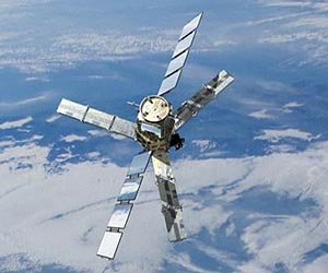
SMOS Microwave Imaging Radiometer using Aperture Synthesis (MIRAS) consists of a central structure and three arms that carry 69 antenna receivers. The instrument employs a new measuring technique in space by operating at frequencies around 1.4 GHz (L-band) to capture images of microwave radiation emitted from Earth.

From an altitude of 758 km and data obtained from a swath width of about 1000 km, SMOS achieves global coverage every three days.

Credits: ESA/AOES Medialab

Spain almost free of radio interference

Following cooperation between ESA and the National Spectrum Authority, SMOS data over Spain, shown in this image from July 2010, are now far less contaminated by radio-frequency interference.

Contaminated SMOS data


As shown in this image from March 2010, data from SMOS over Spain were being badly contaminated before unwanted transmissions from various radio systems were shut down.

Credits: ESA

Thursday, July 1, 2010

ESA's Living Planet Symposium: Innovative SMOS


The satellite carries an innovative sensor to image brightness temperature.

As key observables, these images are used as input to derive global maps of soil moisture and ocean salinity.

Given the success of the mission so far, the maps are expected to be available by the autumn.
Today, a focus at ESA's Living Planet Symposium is on the innovative SMOS mission, which recently became operational.

Early results are proving very encouraging with its first observations due to be released in early July.

ESA's Soil Moisture and Ocean Salinity (SMOS) satellite was launched in November to gather data on moisture in the surface layers of soil and salt in the surface of the oceans.

SMOS will improve our understanding of the water cycle and help advance weather and climate studies.

SMOS has completed an intense programme of calibration and commissioning and, in May, it formally began its operational life delivering data.

Although it is still early days, scientists and users are very impressed with the first snapshots of 'brightness temperature' - the microwave radiation emitted from Earth's surface.

ESA's Mission Manager, Susanne Mecklenburg said, "We still have some way to go before the full soil moisture and ocean salinity data products are available, but the brightness temperature data we have been working on for the past months clearly demonstrate what this advanced mission has to offer."

The satellite carries an innovative sensor to image brightness temperature. As key observables, these images are used as input to derive global maps of soil moisture and ocean salinity. Given the success of the mission so far, the maps are expected to be available by the autumn.

To test the usefulness of SMOS data for numerical weather prediction, data are also being delivered, within three hours of sensing, to meteorological centres such as the European Centre for Medium-Range Weather Forecasts
.

Friday, May 21, 2010

ESA SMOS Mission Video


SMOS will provide global information on surface soil moisture every three days within an accuracy of 4% at a spatial resolution of 50 km. This is comparable to being able to detect one teaspoonful of water mixed into a handful of soil.

Credits: ESA /AOES Medialab

ESA's SMOS water mission goes live - images

ESA - SMOS - ESA's SMOS water mission goes live - images

The Soil Moisture and Ocean Salinity (SMOS) mission makes global observations of soil moisture over Earth’s landmasses and salinity over the oceans.

Variations in soil moisture and ocean salinity are a consequence of the continuous exchange of water between the oceans, the atmosphere and the land – Earth’s water cycle.

Credits: ESA - AOES Medialab

Thursday, November 19, 2009

ESA: SMOS satellite instrument comes alive


Click here to see animation.........

The MIRAS instrument on ESA's SMOS satellite, launched earlier this month, has been switched on and is operating normally. MIRAS will map soil moisture and ocean salinity to improve our understanding of the role these two key variables play in regulating Earth’s water cycle.

"Following the switch-on, MIRAS is working beautifully well with all key subsystems, including all of the receivers, the optical fibres and the correlator unit, in perfect functioning condition," said ESA’s Manuel Martin-Neira, SMOS Instrument Principal Engineer. "We have been able to produce reasonable test data even without in-orbit calibration."

MIRAS (Microwave Imaging Radiometer using Aperture Synthesis) is an L-band radiometer with 69 receivers mounted on three deployed arms to measure the radiation coming from Earth.
In order to measure accurately, the receivers must be within a +/-3°C temperature range of each other, with the optimal operating temperature at 22°C. Heaters are installed on the satellite to achieve the temperature needed.

First MIRAS signal received
Switching on the instrument begins with activating the central payload computer, which controls many of the instrument’s subsystems and gives instructions to the distributed command and monitoring modes on each arm.

To assess the electrical performance of the instrument after switch-on while limiting the consumption of heater power, the physical temperature for start up was set to 10°C.

"The active thermal control is now in operation and is keeping the instrument well within the expected temperature range," Mr Martin-Neira said. "Tomorrow we expect to assess the payload at the final 22°C temperature."

The central payload computer also controls the 'mass memory', which collects all the science data from the receivers and sends them to receiving stations on the ground. The high-speed downlink, which transmits the data to the ground station, was switched on, and data have been transmitted to ESA’s European Space Astronomy Centre (ESAC), in Villafranca, Spain. The data acquisition and processing systems located at ESAC are also working well, and the first test of the product generation system has been successful.

"With the critical launch and early orbit phase completed, the engineers can now evaluate the quality of the downlinks and concentrate on the calibration of the instrument," SMOS Project Manager Achim Hahne said.

Wednesday, October 21, 2009

ESA: SMOS and Proba-2 satellites

As preparations for the launch of SMOS and Proba-2 continue on schedule, the engineers and technicians at the Russian launch site say goodbye as both satellites are encapsulated within the half-shells of the Rockot fairing.

Volker Liebig, ESA’s Director of Earth Observation Programmes, said, “Today, with the encapsulation of the SMOS satellite in the launcher fairing, we have made an important step towards the launch of this key environmental mission, which will investigate two parameters of the complex climate system. I am looking forward to the launch in a few days!”

Proba-2 encapsulated by SMOS launch adapter

The small Proba-2 satellite had already been mated to the Breeze-KM, which is the upper stage of the Russian Rockot, and sealed from view by the SMOS launch adapter above. In launch configuration, Proba-2 sits underneath the SMOS satellite, for injection into orbit after SMOS.


Proba-2 is the second in ESA’s Project for Onboard Autonomy series. Although it is less than a cubic metre, incorporates a total of 17 technology developments and four scientific experiments that focus on solar and space weather.

Michel Courtois, ESA's Director of Technical and Quality Managment, said, "The encapsulation of the Proba-2 satellite was an emotional moment for the project team in Plesetsk. After five years of hard work, our satellite is one step closer to launch, ready to show the importance of in-orbit demonstration of new technologies."

Friday, October 9, 2009

SMOS launch nearing: Media Day at ESA/ESRIN

On Wednesday 21 October, media representatives will have the opportunity to attend an in-depth briefing at ESA’s ESRIN establishment in Frascati near Rome on the upcoming mission of SMOS, ESA’s Soil Moisture and Ocean Salinity satellite scheduled for a Rockot launch from Plesetsk, Russia on 2 November at 02:50 CET.

ESA’s Director of Earth Observation Programmes Volker Liebig, together with other European experts from participating space agencies and industry, will present the SMOS mission and its scientific objectives and will be available for interviews.
Following the successful launch of GOCE on 17 March, SMOS will be the European Space Agency’s second Earth Explorer satellite under its Living Planet Programme to go into orbit. After the successful launch in 2002 of Envisat, the largest Earth observation satellite ever built, ESA started developing the Earth Explorer series of missions to provide a moderate-cost, fast response to important scientific challenges using cutting-edge technologies.

SMOS will primarily observe soil moisture over the Earth's landmasses and salinity over the oceans. Soil-moisture data are urgently required for hydrological studies; ocean-salinity data are vital for improving our understanding of ocean circulation patterns. Data from SMOS will lead to a better understanding of the Earth's water cycle and to better weather and extreme-event forecasting and will contribute to seasonal-climate forecasting. As a secondary objective, SMOS will also provide observations over snow and ice regions, contributing to study of the cryosphere.

SMOS measurement principle
One innovative feature of this mission is that it will demonstrate a new measuring technique adopting a completely different approach to observing the Earth from space. The truly novel MIRAS payload instrument which has been developed is capable of observing both soil moisture and ocean salinity by capturing images of microwave radiation emitted from the Earth’s surface around a frequency of 1.4 GHz (L-band). SMOS will carry the first ever polar-orbiting, space-borne, 2D interferometric radiometer.