Showing posts with label Weather Satellite. Show all posts

Friday, April 11, 2014

ESA Metop Weather Satellite: EADS Airbus maintain their monopoly position

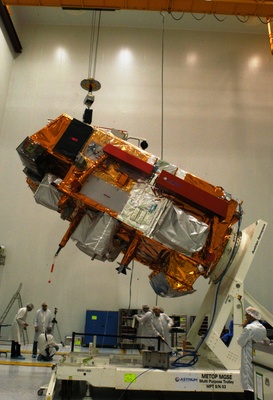
The Metop weather satellites fly pole to pole, sampling conditions in the atmosphere

The competition to build Europe's next generation of polar-orbiting weather satellites has been won by EADS Airbus.

The big aerospace concern was declared the winner at the latest meeting of the European Space Agency's (ESA) Industrial Policy Committee (IPC).

A contract valued in the hundreds of millions of euros will be signed by ESA and EADS Airbus in due course.

Two of the Metop first generation satellites have so far been launched

The existing Metop series, as it is known, has a profound impact on the quality of weather forecasting.

The satellites' sensors gather profiles of atmospheric conditions, layer by layer.

Studies comparing all the different types of meteorological observations (including surface weather stations, balloons and aeroplanes, etc) have found Metop data to have the biggest single contribution to the accuracy of the 24-hour look ahead, at around 25%.

The improved forecasts of storms and other extreme events are estimated to be worth billions of euros annually in terms of lives saved and property damage avoided.

The Metop weather satellites looks down through the different layers in the atmosphere

Thursday's IPC decision is therefore a critically important one for the continent, by ensuring there is continuity of data when the existing series of Metop weather satellites is retired.

"Metop first generation has established itself as an essential series of satellites for weather forecasting. It gives the most detailed measurements from space for such purposes," explained ESA programme manager Graeme Mason.

Monday, March 31, 2014

Russian Rocket launch fails at Kapustin Yar - Weather Satellite payload

A weather rocket launched from Russia's Kapustin Yar launching field crashed in Kazakhstan's western region, according to government reports.

The incident happened early in the morning on March 27, between 1 and 2 a.m., a government source said.

The rocket fell less than one kilometer away from a local village named Shungai with no casualties reported.

According to reports from Kapustin Yar, it was an accident caused by a propulsion system failure, which kept the rocket from reaching its designated destination.

Meanwhile, Kazakhstan's Defense Ministry said it will suspend all Russian missile experiments on leased testing fields in Kazakhstan until the cause of the crash is identified, according to the ministry's website.

"The Ministry of Defense of Kazakhstan has suspended Russia's testing on the leased military grounds in Kazakhstan until the cause of the accident is found," the press office of the Defense Ministry said on Friday.

Kazakhstan's Environmental Regulation and Control Department said soil and air samples will be collected from the crash site to assess the environmental impact.

Kapustin Yar is known to be a launch site for smaller space vehicles. It is also one of Russia's first missile test ranges. During Soviet time a number of intermediate and short range missile projects were tested there.

Thursday, March 6, 2014

NASA JAXA GPM: Earth-based measurements needed to calibrate newest weather satellite

After Atlanta was paralyzed by a rare snowstorm, many fingers were pointed assigning blame for the resulting traffic catastrophe, including at least one aimed at imprecise weather predictions.

"The governor of Georgia said that they thought the heavier snowfall was going to be south of the city," said Ana Barros, professor of civil and environmental engineering at Duke University.

"But there's a lot of uncertainty in those predictions because we don't really understand the fine details of complex storm systems. We don't know how to model these processes at high spatial resolutions."

Ana Barros
This summer, Barros and her colleagues will conduct the first field mission with a new satellite system intended to fill in those knowledge gaps.

On Feb. 27, NASA and Japan's national space agency (JAXA) launched the core satellite for their new Global Precipitation Measurement (GPM) mission from Japan's Tanegashima Space Center.

GPM is an international satellite mission designed to provide more detailed measurements of rain and snow over a wider range of the globe than previously possible.

Not only will the satellite have more precise instrumentation than its predecessors; its orbit will allow researchers to study rainfall at higher latitudes at higher spatial and temporal resolutions.

The data it collects will help unify measurements made by partner satellites and add to science's understanding of how weather works.

Before meteorologists can start plugging the new data in to their weather models, however, researchers have to make sure they can accurately interpret the GPM measurements.

The upcoming field mission, based in the mountains of western North Carolina and led by Duke engineers, will help achieve this by comparing satellite readings with those taken simultaneously from multiple aircraft and ground sensors.

Besides calibrating the new satellite, the campaign will help improve how precipitation processes are represented in forecast calculations.

It will also provide data and inform models used to address critical water management issues in mountainous regions.

"The campaign that we are running will obtain very high-resolution data of precipitation and the microphysics of storm systems in mountainous regions," said Barros.

"The end goal is to improve weather predictions and climate models."

Tuesday, September 18, 2012

ESA Launch: Metop-B the Second European weather Satellite

Watch the replay of the launch of MetOp-B from Baikonur Cosmodrome, Kazakhstan on-board a Soyuz launcher on 17 September 2012. MetOp-B is the second in the series of three identical polar-orbiting weather satellites to provide data for weather forecasting and climate monitoring. MetOp-A was launched in 2006, MetOp-B will be followed by MetOp-C, which is scheduled for launch in 2016.

ESA: Europe launches Metop-B the Second Weather Satellite


The Metop-B weather satellite was successfully launched into orbit last night from the Baikonur cosmodrome, in Kazakhstan.

Metop-B is the second Metop satellite, and its aim is to follow in the footsteps of its predecessor by monitoring the climate and atmosphere. Metop-A has been inhabiting a polar orbit since 2006, but has now exceeded its design lifetime.

The Russian Soyuz-Fregat vehicle launched at 16:28 UTC on September 17, and the weather satellite took up its position in a polar orbit 69 minutes later.

The first few days will be used to test the systems on board the satellite before commissioning of the payload.

Metop-B was developed for the polar satellite system by the European Organisation for the Exploitation of Meteorological Satellites (EUMETSAT), an international collaboration that operates several meteorological satellites.

Control of the satellite will take place at ESA’s Operations Centre in Germany.

Wednesday, September 5, 2012

ESA MetOp-B: Europe's next weather satellite - Launch Simulation

Next ESA MetOpB launch simulation at ESA's ESOC set for Fri, to practise payload activation. 

Credit: ESA

Wednesday, April 4, 2012

ESA Arianespace's Starsem affiliate readies the launch

Credits: ESA 

MetOp-B being readied for testing after arriving at the launch facilities at Baikonur.

ESA's MetOp-B is readied in Starsem’s facilities at Baikonur Cosmodrome, where the weather satellite will be orbited in May by a Soyuz launcher.

Preparations for the 25th mission of Arianespace’s Starsem affiliate are on schedule for a liftoff in the second half of May, using a Soyuz 2 launcher to orbit the European MetOp-B weather satellite from Kazakhstan’s Baikonur Cosmodrome.

With MetOp-B undergoing checkout since being delivered on March 6 to the cosmodrome, the launcher campaign has moved into a new phase with today’s arrival of the Soyuz vehicle’s Fregat M upper stage.

MetOp-B was developed as a joint undertaking between the European Space Agency and EUMETSAT (the European Organisation for the Exploitation of Meteorological Satellites).

It is the second of three nearly identical satellites to provide continuous weather observations until 2020, and follows MetOp-A – which was orbited by Starsem in October 2006 on a Soyuz mission from Baikonur Cosmodrome.

This upcoming flight uses a modernized Soyuz version of the workhorse Russian-built launcher, which also is in service with Arianespace at the Spaceport in French Guiana.

Starsem is Arianespace’s affiliate company created to operate commercial Soyuz missions from Baikonur Cosmodrome.

Its first launch was in February 1999, and the 24 flights performed to date have orbited a diverse range of payloads, including first- and second-generation satellites for Globalstar’s mobile voice and data services, the Cluster II and Corot scientific spacecraft, the Mars Express and Venus Express interplanetary probes, the Galaxy 14 and Amos 2 telecommunications platform, the GIOVE navigation satellite, an Inflatable Reentry and Descent Technology demonstrator, the Radarsat-2 Earth observation satellite, and MetOp-A.

NASA GOES-13: Devastating Texas Tornadoes Seen by Satellite

Tornadoes tore through northeast Texas yesterday (April 3), in an outbreak of severe weather that was captured by a fleet of satellites designed to monitor the situation from space.

At least six tornadoes were reported in the Dallas-Fort Worth area from mid-afternoon to early evening on April 3, according to officials at the National Weather Service.

This image, taken by the GOES-13 (or GOES-East) satellite, shows thick clouds blanketing the Dallas metropolitan area just after 2 p.m. local time yesterday.

"Severe thunderstorms containing very large hail, damaging winds and frequent cloud to ground lightning are continuing across the eastern two-thirds of north Texas," the National Weather Service alerted at the time.

"Strong tornadoes are possible with discrete supercell thunderstorms that occur out ahead of the main line of the storms."

The Texas tornadoes left a trail of heavy damage, but no fatalities were immediately reported. Still, at least 15 people are known to be injured, according to news reports.

Large hailstones from the storm also wreaked havoc, and hundreds of flights to and from the Dallas-Fort Worth International Airport were rerouted or canceled.

In some areas, hailstones reportedly measured more than 2 inches (5 centimeters) wide.

The last time the Dallas metropolitan area was hit by strong tornadoes was in 2000, according to meteorologists.

The National Weather Service uses the GOES satellites to study weather patterns and the climate.

The GOES system (short for Geostationary Satellite system) is made up of four Earth-watching observatories that help with storm tracking and weather forecasting.

Tuesday, March 27, 2012

Soviet Weather Satellite, Meteor-1 to Fall to Earth

Russia is stopping the mission of the Express-AM4 telecommunication satellite, which was launched in August. 

At about 17.32 Moscow time on Sunday, the flight control center will descend the satellite from its orbit, and it will fall into the ocean near the Hawaii Islands. 

To avoid any collisions, the region will be closed for ships and planes for the time of the operation.

Meteor-1, the Soviet Union's first fully operational weather satellite, will on Monday night re-enter the Earth's atmosphere after more than four decades in orbit, the web site of the U.S. Strategic Command said.

The Meteor satellite series was developed in the Soviet Union during the sixties.

On March 26, 1969, a Vostok rocket launched Meteor -1, the very first version of the Soviet Meteor satellite network, into orbit. The satellite terminated operations in July 1970, according to NASA information.

The spacecraft is expected to begin falling at 3:13 a.m. Moscow time on March 27 with debris estimated to fall into the Indian Ocean south of Sri Lanka, the U.S. Strategic Command said.

Weighing between 1,200 and 1,400 kilograms, the Meteor 1-1 spacecraft was originally placed in orbit at an altitude of 650 km, the Space Safety magazine said.

Two solar panels were automatically oriented toward the sun to provide the spacecraft with the maximum amount of solar power.

Meteor-1 provided near-global observations of the earth's weather systems, cloud cover, ice and snow fields, and reflected and emitted radiation from the dayside and nightside of the earth-atmosphere system for operational use by the Soviet meteorological service.

Some of the processed data and TV pictures from the satellite were distributed to meteorological centers around the world.

Tuesday, February 14, 2012

NASA MODIS: Snow in Europe

In early February 2012, much of Europe shivered under the effects of a “Russian Winter” - intense cold and snow triggered by a strong Siberian anticyclone which hovered over northern Russia.

The Moderate Resolution Imaging Spectroradiometer (MODIS) aboard NASA’s Aqua satellite captured this true-color image of the snowy landscape of France and the United Kingdom on February 11, 2012.

In the coldest parts of the year, when the intense cooling of the surface layers of air over northeastern Siberia occurs, the time is right for the formation of a Siberian anticyclone.

Also called a Siberian high, it is a semi-permanent system of high atmospheric pressure centered in northeastern Siberia.

The Siberian anticyclone is one of the principal sources of polar air masses, and outbreaks of polar air westward from the high-pressure area can cause severe cold spells in the European continent.

In early February, 2012, a strong anticyclone formed over northern Russia. On February 3, Mosfiloti Weather Service reported a high pressure of 1061 hPa in that area.

Set against a depression almost 70 hPa lower in southern Greenland, it was a driving force to push frigid temperatures across Europe.

On February 10, CNN reported that twenty-two countries had posted warnings for extreme cold temperatures and accumulating snow. Temperatures of -17 °C (1.4 °F) were reported in Romarantin and -16 °C (3 °F) in Bergerac, France on February 7.

The cold has reached as far south as Algeria, bringing a rare snowfall. The bitter cold and snow not only been inconvenient, tangling traffic and cutting off villages from essential services, especially in Eastern and Central Europe, but it has been deadly as well.

On February 14, the Telegraph reported at least 306 deaths across the continent. The Ukraine has been the hardest hit, with over 131 cold-related deaths reported.

Friday, January 20, 2012

NASA NPP Resumes Mission Checkout Phase

First Global Image from VIIRS

Since its launch from Vandenberg Air Force Base in California on Oct. 28, 2011, the NPP spacecraft and its five instruments have been undergoing initial checkout before starting regular science observations.

Activation and checkout of the full suite of instruments was delayed for several weeks after an anomaly was discovered in the Visible Infrared Imaging Radiometer Suite (VIIRS) instrument.

Following an extensive investigation that successfully identified the cause of the VIIRS instrument anomaly, the checkout and activation process for the full set of NPP instruments was resumed on Jan. 18.

The remaining commissioning activities for NPP are expected to take approximately six weeks.

All NPP instruments were originally scheduled to be operating and collecting data by mid-December. The Advanced Technology Microwave Sounder (ATMS) instrument was activated first and acquired its first measurements on Nov. 8.

ATMS is working well and providing high-spatial-resolution microwave data to take measurements of temperature and humidity in both clear and cloudy conditions. Scientists are already using the ATMS measurements in research studies of rain and snow.

VIIRS acquired its first measurements on Nov. 21. VIIRS is designed to collect radiometric imagery of the Earth's land, atmosphere and oceans using 22 visible and infrared wavelengths.

During checkout, engineers detected a larger than expected decrease in sensor sensitivity in four of VIIRS's near-infrared and visible channels.

As a precaution, activation and checkout of the remaining VIIRS channels and the Cross-track Infrared Sounder (CrIS), the Ozone Mapper Profiler Suite (OMPS) and the Clouds and the Earth's Radiant Energy System (CERES) instruments was delayed until the VIIRS anomaly was better understood.

Investigation of the VIIRS anomaly identified tungsten oxides, an anomalous material on the surface of the mirror. Tungsten oxides could cause the surface of the mirror to darken.

The investigation discovered a non-standard process that occurred during the mirror coating as a potential source of tungsten oxide contamination on the VIIRS mirrors.

This evidence suggests that the cause of the contamination is limited to the VIIRS instrument, and is not a concern for other NPP instruments.

While likely irreversible, the darkening of the VIIRS mirror caused by the contamination is expected to reach a plateau and remain at that level for the life of the mission.

Although testing on this issue is continuing, NPP mission managers expect this plateau to still provide sufficient margins to allow VIIRS to meet its design requirements.

Information from this investigation will be applied to the VIIRS instrument currently in development for the National Oceanic and Atmospheric Administration's Joint Polar Satellite System.

After commissioning and a calibration/validation period, NPP data will be available from NOAA's Comprehensive Large Array-data Stewardship System:

http://www.class.noaa.gov/

Thursday, October 27, 2011

NASA: NPP Polar Orbiting Environmental /Weather Satellite


The launch of a new polar-orbiting environmental satellite enables NOAA to continue issuing accurate
forecasts and provide advance warning for severe weather, such as deadly tornado outbreaks, blistering
heat waves, floods, snowfall and wildfires.

The satellite, NASA’s NPOESS Preparatory Project (NPP), orbits Earth every 102 minutes, flying 512 miles above the surface, and capturing data from the Earth’s land, oceans, and atmosphere.

The data is used by NOAA forecasters to detect the potential for dangerous weather conditions days – even several weeks, in advance.

For example, data from polar-orbiting satellites helped NOAA meteorologists predict, 5 days in
advance, the major snowstorms that struck the Atlantic Coast in February 2010 (“Snowmageddon”) and
paralysed New York City in December 2010.

For more information on NOAA and NPP click on the link  here


Saturday, September 3, 2011

NASA Landsat Program - Etosha Pan, Namibia

In north Namibia, the Etosha pan—a 75-mile long dry lakebed—makes up part of the Namib Desert.

The Etosha salt pan is mostly made up of dry mud and salt.

The Ekuma River is the salt pan’s sole source of water.

In this image the Etosha pan is blue, violet, cyan and white.

Vegetation is green and bare ground appears brown, pink and red. Clouds are white.

This Landsat 7 image was acquired April 22, 2000.

It is a false colour image using ETM+ bands 7,4, and 2.

The Etosha pan falls on Landsat WRS-2 Path 179 Row 73.

References
Wikipedia. Etosha pan.
More feature images.

NASA Landsat Program - Chesapeake Bay

USGS has released a new mosaic of the Chesapeake Bay.

Using six Landsat 5 images collected in July 2009 and 2011 a beautiful, seamless mosaic of the Chesapeake Bay region was created by the USGS Landsat team.

The Washington D.C.-Baltimore-Philadelphia-New York City corridor can be clearly seen (look for silvery purple) as can the Chesapeake and Delaware Bays and the coastal Atlantic barrier islands from Fishermans Island, Virginia to Sandy Hook, New Jersey.

Friday, June 24, 2011

NASA Aqua Image: 2 Cyclones in one InfraRed Image

The Northwestern Pacific Ocean is active with two tropical cyclones today, Tropical Storm Meari near the Philippines, and Tropical Depression Haima moving over China and now toward Vietnam.


NASA's Aqua satellite passed over the region on June 22 and captured an infrared image of both storms in one image.

One of the instruments onboard NASA's Aqua satellite is the Atmospheric Infrared Sounder (AIRS).

AIRS captures cloud top temperatures in tropical cyclones to determine the strength of convection and thunderstorms.

The strongest thunderstorms have cloud tops with icy cold temperatures of -63F/-52C and are indicative of areas where rainfall rates could reach up to 2 inches / 50 mm per hour and both Meari and Haima had large areas of those very cold cloud top temperatures.

AIRS captured the image on June 22 at 17:53 UTC 1:53 p.m. EDT and it showed the heaviest rainfall and strongest convection (rapidly rising air that forms the thunderstorms that power a tropical cyclone) from Tropical Storm Meari is currently over the Philippine Sea and skirting the east coast of Luzon.

The imagery showed the large area of strong thunderstorms (and convection) in Haima mostly over the South China Sea and Hainan Island, China.

Haima is still a tropical depression as its maximum sustained winds on June 23 at 1500 UTC (11 a.m. EDT) were near 30 knots (34 mph/55 kmh). Tropical storms have maximum sustained winds between 38 and 73 mph.

It was located over Hainan Island, China, and about 235 nautical miles west-southwest of Hong Kong, China near 21.4 North and 109.6 East. Tropical Depression Haima is moving westward at 10 knots (11 mph/19 kmh).

Thursday, March 11, 2010

Controversy Over ESA MeteoSat Contract: European Weather Satellite

ESA Website link to MTG Sentinel-2 satellites

German government officials are blaming their own tactical error during negotiations with France for the controversy that has blocked approval of Europe’s $1.7 billion next-generation weather-satellite program since the beginning of the year and now threatens to cause lasting damage to the 18-nation European Space Agency (ESA), German government and industry officials said.

ESA’s ruling council is scheduled to meet March 17 in Paris to attempt to forge a compromise that would permit the German government to save face while at the same time approving a Meteosat Third Generation (MTG) contract valued about around 1.25 billion euros ($1.7 billion) with a consortium led by Thales Alenia Space of France and Italy, and OHB Technology of Germany.

That winning bid, in which Thales Alenia Space’s French division would be prime contractor, bested a bid by Astrium Satellites of Germany.

An ESA Technical Evaluation Board met three times before concluding that the Thales Alenia-OHB bid, which came in about 150 million euros lower than Astrium’s offer, should be favored for negotiations in view to a contract.

The decision to favor a French prime contractor — even one teaming with a German partner — has struck a raw nerve in Germany, particularly at the German Transport Ministry, which funds Germany’s contributions to Europe’s Eumetsat meteorological satellite organization.

Click on this link to read the full article