Showing posts with label goes. Show all posts

Monday, September 16, 2013

NASA GOES: Three tropical cyclones in one shot

On Saturday, Sept. 14, NOAA's GOES-East saw newborn Tropical Storm Manuel in the eastern Pacific, Tropical Storm Ingrid in the southwestern Gulf of Mexico, the remnants of Gabrielle absorbed into a cold front over the North Atlantic, and Tropical Depression Humberto in the eastern Atlantic. 

Credit: NASA Goes Project

There were three tropical cyclones between the north Eastern Pacific and the North Atlantic Ocean on Saturday, Sept. 14, and NOAA's GOES-East satellite captured them in one image created by NASA.

Because Mexico was being hit with Tropical Storm Ingrid and Manuel, both coasts were under Tropical Storm Warnings.

The National Hurricane Center cautioned that some areas in eastern and western Mexico may receive up to two feet of rainfall from each storm!

NASA's GOES Project at the NASA Goddard Space Flight Center uses the data gathered by NOAA's GOES series of satellites and makes them into images and animations.

On Saturday, Sept. 14 at 1145 UTC/7:45 a.m. EDT, an image was created that showed newborn Tropical Storm Manuel in the eastern Pacific, Tropical Storm Ingrid in the southwestern Gulf of Mexico, the remnants of Gabrielle absorbed into a cold front over the North Atlantic, and Tropical Depression Humberto in the eastern Atlantic.

Monday, April 22, 2013

NASA Terra Mission Image: MODIS Earth Observation - Climate Change

NASA launched the Earth Observing System's flagship satellite "Terra," named for Earth, on December 18, 1999. 

Terra has been collecting data about Earth's changing climate.

On February 24, 2000, sensors on NASA's Terra satellite began opening their shutters and making their first observations. 

The mission ushered in a decade of observations from NASA's Earth Observing System, a coordinated series of satellites that monitor how Earth is changing.

This image is based largely on observations from the Moderate Resolution Imaging Spectroradiometer (MODIS) - a sensor aboard the Terra Satellite - on July 11, 2005. 

Small gaps in MODIS’ coverage between overpasses, as well as Antarctica (which is in polar darkness in July), have been filled in using GOES weather satellites and the latest version of the NASA Blue Marble.

Image Credit: NASA

Thursday, December 27, 2012

NOAA GOES Satellite Image: Storm front

A storm front is pictured over the east coast of the United States in this NASA satellite image. 

Picture: REUTERS/NASA/NOAA/GOES Project

Tuesday, July 17, 2012

SDO Image of Latest CME and Solar Flares

The Sun is becoming increasingly active as it heads towards the maximum of the eleven year solar cycle in 2013, and two powerful solar flares have erupted so far this month.

The first flare erupted from the limb of the solar disc in active region 1515 on 6 July, and was classed as an X 1.1 flare.

X-class flares are the most powerful type of solar flares, with M-class being slightly less powerful.

On 12 July, an X 1.4 flare was emitted from active region 1520, which first rotated into view on 6 July.

The active region of sunspots stretched for around 300,000 kilometres across the solar surface.

There was also a coronal mass ejection (CME) associated with the flare.

The CMEs are much larger eruptions than the localised flares, and move towards Earth at a slower speed than the flares.

CMEs can impact the technological infrastructure on Earth, such as power generation as well as satellite functions in orbit.

Their arrival also produces aurora and astronomers have been on alert to search for and photograph the dancing green glows.

The Solar Terrestrial Relations Observatory (STEREO) B spacecraft measured the speed of the CME travelling to Earth to be around 1350 kilometres per second.

The particles from the CME hit the Earth’s atmosphere on the night of 14 July, and aurorae were reported at high latitudes.

The image shows the Sun as seen by NASA’s Solar Dynamics Observatory (SDO) on 12 July shortly before the X 1.4 flare was released.

The picture combines a set of observations known as magnetogram with light at a wavelength of 171 Angstroms.

The magnetogram highlights magnetic field lines on the Sun, and assists scientists in understanding the dynamics of the solar magnetic field prior to an outburst.

The light at 171 Angstroms is used to emphasise the giant loops of material emanating from active region 1520.

The 12 July flare is the sixth X-class flare of 2012, and it is likely that there will be many more to come.

Read more about CMEs and Solar Flares: Space Weather

Wednesday, April 4, 2012

NASA GOES-13: Devastating Texas Tornadoes Seen by Satellite

Tornadoes tore through northeast Texas yesterday (April 3), in an outbreak of severe weather that was captured by a fleet of satellites designed to monitor the situation from space.

At least six tornadoes were reported in the Dallas-Fort Worth area from mid-afternoon to early evening on April 3, according to officials at the National Weather Service.

This image, taken by the GOES-13 (or GOES-East) satellite, shows thick clouds blanketing the Dallas metropolitan area just after 2 p.m. local time yesterday.

"Severe thunderstorms containing very large hail, damaging winds and frequent cloud to ground lightning are continuing across the eastern two-thirds of north Texas," the National Weather Service alerted at the time.

"Strong tornadoes are possible with discrete supercell thunderstorms that occur out ahead of the main line of the storms."

The Texas tornadoes left a trail of heavy damage, but no fatalities were immediately reported. Still, at least 15 people are known to be injured, according to news reports.

Large hailstones from the storm also wreaked havoc, and hundreds of flights to and from the Dallas-Fort Worth International Airport were rerouted or canceled.

In some areas, hailstones reportedly measured more than 2 inches (5 centimeters) wide.

The last time the Dallas metropolitan area was hit by strong tornadoes was in 2000, according to meteorologists.

The National Weather Service uses the GOES satellites to study weather patterns and the climate.

The GOES system (short for Geostationary Satellite system) is made up of four Earth-watching observatories that help with storm tracking and weather forecasting.

Tuesday, May 24, 2011

Grimsvotn May 2011 eruption seen by the US GOES-13 satellite


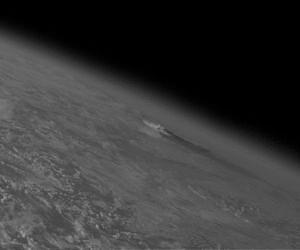
The start of the Grimsvotn May 2011 eruption as seen by the US GOES-13 satellite.

The volcanic plume was apparent on the very edge of GOES-east imagery, which can be seen in the animation of visible channel images. 

The oblique viewing angle from this satellite helped to emphasise the large vertical extent of the erupted plume. 

Credits: Cooperative Institute for Meteorological Satellite Studies.

Friday, May 14, 2010

Medieval art goes 3D


May 5 - A new exhibition showing the works of Italian medieval master Giotto, allows visitors to watch restorers at work and to ''step inside'' the artist's paintings thanks to 3D technology. Stuart McDill reports. (01:28)

Saturday, December 5, 2009

NASA MARS: Odyssey Orbiter goes into Safe Standby Mode

NASA's Mars Odyssey orbiter put itself into a safe standby mode on Saturday, Nov. 28, and the team operating the spacecraft has begun implementing careful steps designed to resume Odyssey's science and relay operations within about a week.

Engineers have diagnosed the cause of the Nov. 28 event as the spacecraft's proper response to a memory error with a known source. The likely cause is an upset in the orbiter's "memory error external bus," as was the case with a similar event in June 2008.

In safe mode over the weekend, Odyssey remained in communication with ground controllers and maintained healthy temperatures and power. To clear the memory error, the team commanded Odyssey today to perform a cold reboot of the orbiter's onboard computer. The spacecraft reported that the reboot had been completed successfully.

"This event is a type we have seen before, so we have a known and tested path to resuming normal operations," said Odyssey Project Manager Philip Varghese of NASA's Jet Propulsion Laboratory, Pasadena, Calif.

Odyssey has been orbiting Mars since 2001. In addition to its own major scientific discoveries and continuing studies of the planet, the Odyssey mission has played important roles in supporting the missions of the Mars rovers Spirit and Opportunity and the Phoenix Mars Lander.

Until Odyssey is available again as a communications relay, Spirit and Opportunity will be operating with direct communications to and from Earth.