Showing posts with label Canada. Show all posts

Sunday, July 27, 2014

ESA Astronaut Alexander Gerst on the ISS

ESA astronaut Alexander Gerst floats through the International Space Station. 

As part of his Blue Dot mission he will perform many scientific experiments in weightlessness that could not be done on Earth.

The International Space Station is a partnership between 15 countries, including Russia, USA, Canada, Japan and ESA member states.

Credits: ESA/NASA

Wednesday, May 28, 2014

CSA Dextre: ISS Space robot repairs itself

Dextre, the Canadian Space Agency’s robotic handyman aboard the International Space Station. 

Credit: CSA/NASA

In a thrilling demonstration of space robotics, today the Dextre "hand" replaced a malfunctioning camera on the station's Canadarm-2 robotic arm.

And the Canadian Space Agency gleefully tweeted every step of the way, throwing in jokes to describe what was happening above our heads on the International Space Station.

"Dextre's job is to reduce the risk to astronauts by relieving them of routine chores, freeing their time for science," the Canadian Space Agency tweeted today (May 27) .

"Spacewalks are thrilling, inspiring, but can potentially be dangerous. They also take a lot of resources and time. So Dextre is riding the end of Canadarm-2 today instead of an astronaut. And our inner child is still yelling out 'Weeeee…!' "

The complex maneuvers actually took a few days to accomplish, as the robot removed the broken camera last week and stowed it.

Today's work (performed by ground controllers) was focused on putting in the new camera and starting to test it. You can see some of the most memorable tweets of the day below.

The cookie you see in the first tweet is part of a tradition in Canada's robotic mission control near Montreal, Que., where controllers have this snack on the day when they are doing robotic work in space.


Incidentally, the Canadian Space Agency bet NASA a box of maple cream cookies in February during a gold-medal Olympic hockey game between the two countries, which Canada won.

Monday, May 5, 2014

Brilliant Daytime Fireball Streaks Over Canada, New York - Video


A brilliant fireball surprised some skywatchers Sunday (May 4) when it streaked across the daytime sky over Toronto in a celestial fireworks display caught on camera by lucky motorists.

A well-placed dashboard video camera captured the light of the bright meteor, which could be seen from parts of Canada and New York on May 4.

The daytime fireball video shows a clear view from a parked car with people chatting in the background.

The meteor comes streaking down from the top of the sky at about the 22-second mark, with a clear outburst of light occurring at about 24 seconds.

"There was a fireball that came down and burned up," one of the people recorded by David Narciso's dashcam said after the fireball streaked through the daylight sky.

"See that line of puff? There was, like, something on fire and then it just stopped."

The fireball is concurrent with, but may not be related to, the Eta Aquarid meteor shower set to peak tonight (May 5) and into the wee hours of tomorrow (May 6) morning.

The annual shower happens when Earth passes through debris left behind by Halley's Comet. This year, the meteors will probably appear low on the horizon

Monday, November 25, 2013

Urthecast: Canadian video camera launches to International Space Station

A Russian Progress freighter has launched to the International Space Station (ISS) carrying a pair of Canadian Earth observation cameras, built in the UK.

One of the imagers is a high-resolution video unit that will return short snatches of the planet's surface up to about 150 times a day.

The Rutherford Appleton Laboratory in Oxfordshire made the cameras for a Canadian start-up called Urthecast.

The company hopes to build a business around space station imagery.

One of the customer sectors for the hi-res video, for example, is likely to be news organisations that want moving pictures of major events, such as war zones and regions of the Earth hit by natural disasters.

This space camera is one of two developed by Vancouver-based Urthecast that were launched Monday, bound for the International Space Station, where they’re expected to transmit images of Earth on the Internet.

Photograph by: HO, THE CANADIAN PRESS

The movie camera should be able to pick out details as small as a metre across from the ISS's altitude of 400km.

This means it ought to be possible to discern large crowds and moving vehicles.

The second camera will provide static imagery at a resolution of 5m per pixel.

Urthecast hopes to have both units operational in the New Year, shortly after they have been installed on a special gantry at the rear of the station by spacewalking astronauts.

The Progress-53 cargo ship lifted clear of the Baikonur Cosmodrome in Kazakhstan atop a Soyuz rocket at 02:53 local time (Tuesday, 26 November - 20:53 GMT, Monday).

Scott Larson, the CEO of Urthecast, was at the Kazakh spaceport to witness launch.

"There are a lot of very happy Canadians, a lot of very happy Brits and a lot of very happy Russians," he said.

"It is truly spectacular. We are just incredibly grateful and thankful to have the opportunity to come here, and for all the hard work that has gone into it."

The Progess docking at the ISS is planned for Friday. As well as the cameras, the freighter is carrying general hardware, food, and fuel needed by the station's astronauts.

Thursday, November 14, 2013

NASA and NOAA help reveal melt secrets of Great Lakes ice

A colour-coded image of major ice types on Lake Superior, made from a RADARSAT1 radar backscatter image using a new NASA and NOAA-developed technique. 

Credit: NOAA Great Lakes Environmental Research Laboratory and NASA/JPL-Caltech

Two scientists from NASA and NOAA have developed a new space-based technique for monitoring the ice cover of the Great Lakes that is so accurate it can identify a narrow channel of open water cut through the ice by an icebreaker—even at night.

"In the dark, it's difficult to read a map that's right in front of you," said Son Nghiem of NASA's Jet Propulsion Laboratory, Pasadena, Calif., one of the developers of the new technique.

Son Nghiem
"Yet we now have a way to use satellite radars almost 500 miles [800 kilometers] out in space to see through clouds and darkness and map ice across the Great Lakes."

Ice on the Great Lakes puts a big chill on the U.S. and Canadian economies, affecting shipping, fishing and also public safety when winter and spring flooding are caused by ice jams.

It has a significant impact on the regional environment and ecological systems as well. Yet previous techniques of analyzing satellite observations of the ice sometimes misidentified ice as water and vice versa.

The new method, co-developed by Nghiem and his colleague George Leshkevich of NOAA's Great Lakes Environmental Research Laboratory, Ann Arbor, Mich., not only corrects that problem, it also gives a more accurate analysis of ice characteristics, such as whether the ice is dense or full of bubbles, and whether it has melted and refrozen.

Leshkevich said the method has now been transitioned to NOAA for routine use in generating ice maps across the Great Lakes.

"These maps will provide important information for environmental management, ice forecasting and modeling, off-shore wind farm development, operational icebreaking activities in support of winter navigation, and science research."

The more accurate classification of ice will also be useful for scientific research into such questions as how the Great Lakes are responding to, and leading, climate change in the upper Midwest.

More information: www.iaglr.org/jglr/release/39/2013.05.003_leshkevich.php

Thursday, May 16, 2013

Canada: Billion-year-old water could hold clues to life on Mars

A UK-Canadian team of scientists has discovered ancient pockets of water, which have been isolated deep underground for billions of years and contain abundant chemicals known to support life.

This water could be some of the oldest on the planet and may even contain life.

Not just that, but the similarity between the rocks that trapped it and those on Mars raises the hope that comparable life-sustaining water could lie buried beneath the red planet's surface.

The findings, published in Nature today, may force us to rethink which parts of our planet are fit for life, and could reveal clues about how microbes evolve in isolation.

Researchers from the universities of Manchester, Lancaster, Toronto and McMaster analysed water pouring out of boreholes from a mine 2.4 kilometres beneath Ontario, Canada.

They found that the water is rich in dissolved gases like hydrogen, methane and different forms – called isotopes – of noble gases such as helium, neon, argon and xenon. Indeed, there is as much hydrogen in the water as around hydrothermal vents in the deep ocean, many of which teem with microscopic life.

The hydrogen and methane come from the interaction between the rock and water, as well as natural radioactive elements in the rock reacting with the water.

These gases could provide energy for microbes that may not have been exposed to the sun for billions of years.

The crystalline rocks surrounding the water are thought to be around 2.7 billion years old but no-one thought the water could be the same age, until now.

Using ground-breaking techniques developed at the University of Manchester, the researchers show that the fluid is at least 1.5 billion years old, but could be significantly older.

Chris Ballentine
NERC-funded Professor Chris Ballentine of the University of Manchester, co-author of the study, and project director, says: 'We've found an interconnected fluid system in the deep Canadian crystalline basement that is billions of years old, and capable of supporting life. Our finding is of huge interest to researchers who want to understand how microbes evolve in isolation, and is central to the whole question of the origin of life, the sustainability of life, and life in extreme environments and on other planets.'

Before this finding, the only water of this age was found trapped in tiny bubbles in rock and is incapable of supporting life but the water found in the Canadian mine pours from the rock at a rate of nearly two litres per minute.

It has similar characteristics to far younger water flowing from a mine 2.8 kilometres below ground in South Africa that was previously found to support microbes.

Greg Holland
Ballentine and his colleagues don't yet know if the underground system in Canada sustains life, but Dr Greg Holland of Lancaster University, lead author of the study says: 'Our Canadian colleagues are trying to find out if the water contains life right now. What we can be sure of is that we have identified a way in which planets can create and preserve an environment friendly to microbial life for billions of years. This is regardless of how inhospitable the surface might be, opening up the possibility of similar environments in the subsurface of Mars.'

Professor Ballentine, based in Manchester's School of Earth, Atmospheric and Environmental Sciences, adds: 'While the questions about life on Mars raised by our work are incredibly exciting, the ground-breaking techniques we have developed at Manchester to date ancient waters also provide a way to calculate how fast methane gas is produced in ancient rock systems globally. The same new techniques can be applied to characterise old, deep groundwater that may be a safe place to inject carbon dioxide.'

David Willetts, Minister for Universities and Science, says: 'This is excellent pioneering research. It gives new insight into our planet. It has also developed new technology for carbon capture and storage projects. These have the potential for growth, job creation and our environment.'

More information: 
Deep fracture fluids isolated in the crust since the Precambrian era, by G. Holland, B. Sherwood Lollar, L. Li, G. Lacrampe-Couloume, G. F. Slater & C. J. Ballentine, in Nature, 16 May 2013. dx.doi.org/10.1038/nature12127

Friday, April 12, 2013

Can you see the face in Eua Island, Tonga?

Can you see the face in Eua Island, Tonga?

Credit: NASA/CSA/Chris_Hadfield

Thursday, April 11, 2013

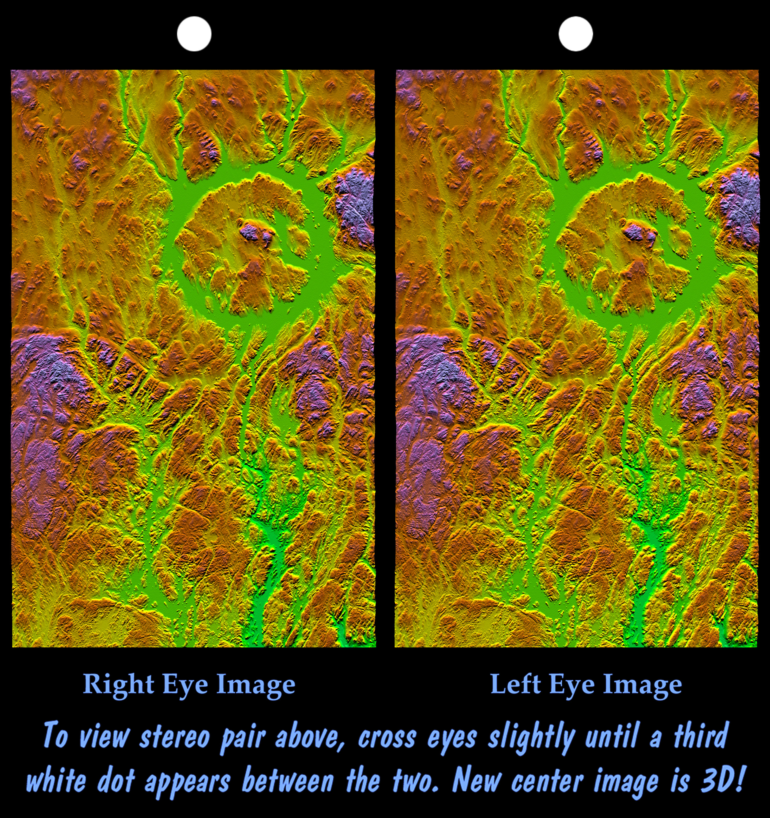
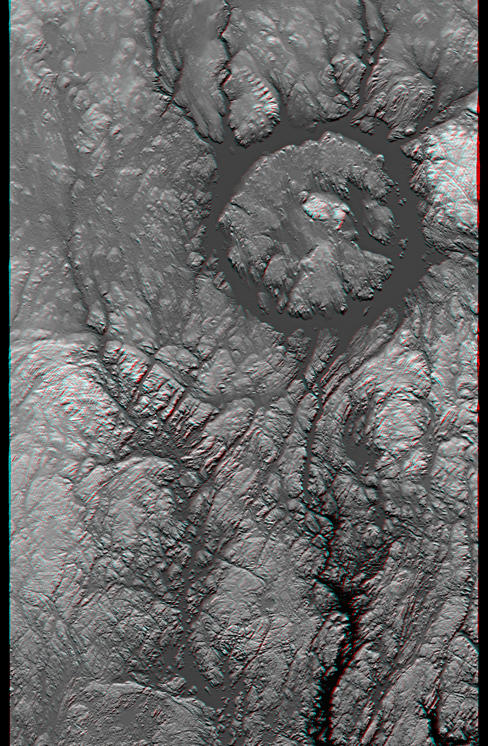
NASA Earth Observation: Manicouagan Impact Crater, Canada

Manicouagan Crater is one of the world’s largest and oldest known impact craters and perhaps the one most readily apparent to astronauts in orbit.

The age of the impact is estimated at 214 million years before present.

Since then erosion has removed about one kilometer (0.6 miles) of rock from the region and has created a topographic pattern that follows the structural pattern of the crater.

A ring depression (prominently seen as green) encloses a central peak.

The ring depression now hosts the Manicouagan Reservoir and so appears as a distinct ring lake to astronauts and as a smooth and flat feature in this topographic visualization.

A fine pattern of topographic striations trending south-southeast, most prominent within the crater itself, indicates the flow direction of glaciers that covered this area during the last ice age.

Read the full article here at NASA Earth Observation also available is a stereo and anaglyph version of this image.

Thursday, April 4, 2013

Sun's Magnetic 'Heartbeat' Revealed

A simulation of magnetic fields at the time of solar maximum.

CREDIT: University of Montreal Solar Physics Research Group

A magnetic "solar heartbeat" beats deep in the sun's interior, generating energy that leads to solar flares and sunspots, according to new research.

A new supercomputer simulation, described in the April 4 edition of the journal Science, probes the sun's periodic magnetic field reversals.

Every 40 years, according to the model, the sun's zonal magnetic field bands switch their orientation, or polarity.

That cycle is about four times longer than the 11-year sunspot cycle that governs the level of solar activity. Being able to model such a regular, long-term process is remarkable, the scientists said.

The new research, led by the University of Montreal's Paul Charbonneau, describes work from both his research group and other, independent coalitions simulating the sun's interior.

Temperature variability on a model intended to approximate what goes on inside the sun.

CREDIT: University of Montreal Solar Physics Research Group

Dissipating turbulence
Modeling the sun has been a sticky problem for decades.

The first attempts in the 1980s captured only a rough approximation of the turbulence inside of the sun.

Turbulence, when it occurs, happens at both large and small scales.

The large scales are easy to simulate, but in the sun, a small feature only about tens of miles across is just as important in understanding how fluid propagates.

When energy from turbulence dissipates, the turbulence flows into smaller and smaller whirlpool shapes, called vortices.

You can see this for yourself, Charbonneau said, when swirling your hand in a full bathtub. The movement will produce a vortex in the water that will gradually break up into tinier ones that dissipate the energy.

On the sun, dissipation takes place at a scale of tens of yards. That's extremely minute, compared with the size of the sun, which is 1 million times larger than Earth. "There's no way we can capture that in a simulation," Charbonneau stated.

To approximate this process, scientists typically limit the resolution to about 6.2 miles (10 kilometers). This, however, creates an energy buildup in the simulation that will "blow up" the model before it can run for very long, Charbonneau said.

Wednesday, March 27, 2013

ESA Herschel Image: How to Build a Very Large Star

This image does not show any stars because the Herschel Space Observatory’s cameras record far-infrared light instead of visible light. 

Gas is not visible either, even though it makes up most of the 400,000 solar masses of matter in this cloud: dust amounts to only about one percent of the mass. 

Credit: ESA/PACS Array SPIRE consortium, A. Rivera-Ingraham and P. G. Martin, University of Toronto, HOBYS Key Programme (F. Motte)

Stars ten times as massive as the Sun, or more, should not exist: as they grow, they tend to push away the gas they feed on, starving their own growth.

Scientists have been struggling to figure out how some stars overcome this hurdle.

Now, a group of researchers led by two astronomers at the University of Toronto suggests that baby stars may grow to great mass if they happen to be born within a corral of older stars –with these surrounding stars favorably arranged to confine and thus feed gas to the younger ones in their midst.

The astronomers have seen hints of this collective feeding, or technically “convergent constructive feedback,” in a giant cloud of gas and dust called Westerhout 3 (W3), located 6,500 light years from us.

Their results are published in the upcoming month in The Astrophysical Journal.

Alana Rivera-Ingraham
“This observation may lift the veil on the formation of the most massive stars which remains, so far, poorly understood,” says Alana Rivera-Ingraham, who led the study while she was a graduate student in the Department of Astronomy and Astrophysics at the University of Toronto, Canada, and is currently a postdoctoral researcher at the Institut de Recherche en Astrophysique et Planétologie in Toulouse, France.

To study the formation of high-mass stars, Rivera-Ingraham and collaborators used high-quality and high-resolution far-infrared images from a space telescope launched by the European Space Agency in 2009 —the Herschel Space Observatory.

This telescope’s two cameras recorded light that is not visible to the naked eye, spanning a range from infrared radiation partway to the microwave region.

Peter Martin
Exploiting these cameras, scientists including Peter Martin, Professor in the Canadian Institute for Theoretical Astrophysics at the University of Toronto, created the HOBYS Key Programme to study the birth of very massive stars in nearby giant clouds of gas and dust in our own Galaxy, including W3.

Research on HOBYS at the University of Toronto is supported in part by the Canadian Space Agency and the Natural Sciences and Engineering Research Council of Canada.

Scientists track the regions of the gas cloud where stars are about to form by mapping the density of dust and its temperature, looking for the most dense regions where the dust is shielded and cold.

“We can now see where stars are about to be born before it even happens, because we can detect the cold dust condensations,” says Martin. “Until Herschel, we could only dream of doing that.”

Stars are born in the denser parts of gas clouds, where the gas gets compressed enough by gravity to trigger nuclear fusion. The more massive the newborn star, the more visible and ultraviolet light it emits, heating up its surroundings —including the dust studied by Herschel.

“The radiation during the birth of high-mass stars is so intense that it tends to destroy and push away the material from which they need to feed for further growth,” says Rivera-Ingraham.

Scientists have modeled this process and found that stars about eight times the mass of our Sun would stop growing because they run out of gas.

Reference
Herschel Observations of the W3 GMC: Clues to the Formation of Clusters of High-Mass Stars. The Astrophysical Journal, 2013

Thursday, March 7, 2013

Hadfield and the Dragon - Image

Credit: Chris Hadfield / Canadian Space Agency

Canadian astronaut Chris Hadfield poses with SpaceX's Dragon capsule after it docked successfully with the International space station.

Saturday, March 2, 2013

CFH Telescope Image:The Lagoon Nebula, Messier 8

Credit: Canada-France-Hawaii Telescope/Coelum

The Lagoon Nebula, also called Messier 8, lies deeply embedded in the disk of our galaxy. 

Stars form within this giant region, and they gravitationally cluster in the heart of the nebula. 

Ultraviolet radiations from newborn stars ionize hydrogen gas, creating the pink emission.

Canada funds Non-Nuclear sources for Medical Isotopes

Canada expects to be able to make enough medical isotopes through non-nuclear methods by 2016 to replace those now produced by an aging reactor and better assure an uninterrupted supply for medical imaging, a government minister said on Thursday.

To that end, the federal government will fund three research institutes developing cyclotron and linear accelerator technologies for production of isotopes on a commercial scale, Natural Resources Minister Joe Oliver said.

Canada's only current source of the isotopes is a problem-plagued reactor at Atomic Energy of Canada Ltd's facility at Chalk River, Ontario.

The reactor is licensed to run until 2016. "Our challenge now is to prove that cyclotron and linear accelerator production can be commercially viable. ... We envision a future where isotope production will no longer require highly enriched uranium — a weapons-grade material," he said.

The government will give a total of C$25 million ($24.3 million) to the three facilities for this goal.

Asked if there would be a gap between the end of production by the Chalk River reactor and the supplies from the other sources, Oliver said he did not think so, since the technology was proven and what remained was commercialization.

"That's been worked on for a while," he told reporters after making the announcement. "It's reached a fairly robust stage right now. We're talking about increasing the amount ... and we're comfortable we can meet those objectives by 2016."

Chalk River facility
Oliver also announced Canada wanted a private operator to run the Chalk River facility, a move that would take two years to accomplish.

The temporary closure of the Chalk River reactor for safety reasons in 2007 and then again from May 2009 to August 2010 caused a medical challenge and a political furor as the government scrambled to find isotope replacements internationally.

The closures dealt a blow to Nordion Inc, which as a major supplier of isotopes relied on Chalk River. Nordion had no immediate comment on Thursday's announcement.

AECL had built two more modern prototype reactors to make isotopes but eventually mothballed them after a series of problems. An arbitration panel last year rejected Nordion's claim for damages against AECL.

A CANDU Nuclear Facility
Oliver said the government was not seeking to close down or sell the Chalk River nuclear laboratories.

In October 2011 Canada sold AECL's Candu nuclear reactor division to a subsidiary of SNC Lavalin Group Inc.

Friday, March 1, 2013

Bonnie but Rugged: Canadian Astronaut Hadfield snaps Scotland from ISS

"Bonnie but Rugged!" Loch Lomond and the Clyde estuary in view here.

Cmdr Hadfield: "The ruggedness of Scotland evident in the snowy hills and lochs north of the Firth of Clyde." 

First Minister Alex Salmond tweeted the astronaut saying he was impressed with his photography. 

Cmdr Hadfield responded by saying he hoped to visit Scotland when he was "back on earth". 


The "Whiskey Islands" - The Isle of Skye photographed by Cmdr Hadfield - he described them as "a stirring landscape". 

The islands of Canna, Rum, Eigg, and Muck are visible to the south of Skye, as well as the mainland from Loch Torridon down to Loch Nevis. Cmdr Hadfield said: 


"Edinburgh to Dundee, with the big Tay and Forth bridges visible. 


Wednesday, February 6, 2013

Wideband GLOBAL Satcom Partnership: Radarsat Constellation Mission

The Canadian government hopes to adopt the U.S. Air Force’s Wideband Global Satcom (WGS) partnership model for Canada’s three-satellite Radarsat Constellation Mission (RCM) by asking other nations to add their spacecraft to improve RCM performance, Canadian defense officials said.

The effort has picked up steam since the Jan. 9 announcement by the Canadian government that it was funding RCM’s full development, launch and first year of operations, with the first of the three satellites to be launched in 2018.

“Our phone has rung a couple of times,” said Col. Andre Dupuis, director of space requirements at Canada’s National Defence Headquarters, when asked whether other nations have expressed interest in joining the RCM effort. He declined to be specific, but said the industrial component of any collaboration may prove more complicated than establishing the necessary bilateral relations with prospective contributing governments.

Addressing the Defence Geospatial Intelligence 2013 conference here organized by Worldwide Business Research, Dupuis said the performance of an RCM-based constellation of satellites would substantially improve if it grew to as many as six satellites in the same orbit to reduce the amount of time between flights over a given point on Earth.

WGS nations contributing to the purchase of additional satellites automatically receive pro rata access to the entire constellation. It is a model also used in Earth observation by the DMC International Imaging Ltd. of Britain, which manages a five-satellite optical-imaging constellation on behalf of contributors from Britain, China, Nigeria, Turkey, Spain and Algeria.

One of the more obvious candidates for a collaboration with Canada would be Germany, whose civil TerraSAR-X and TanDEM-X radar satellites are in orbit and operated by Astrium Geo-Information Services of Europe in a partnership with the German Aerospace Center, DLR.

Astrium and DLR have been negotiating for months on a second-generation TerraSAR-X — the satellite was launched in 2007 and has a seven-year contracted design life — but thus far have not come to an agreement. Astrium had been scheduled to finance the second-generation system on its own, but has found the global market for radar imagery tougher to crack than forecast.

In a Jan. 24 briefing with journalists, DLR Chairman Johann-Dietrich Woerner said he expected DLR and Astrium to conclude their negotiations this year. Woerner said DLR is also looking for international partners on an L-band radar-imaging system, and that a decision here would also be made in 2013.

Woerner said he was in Canada when the government made the RCM announcement, and that he was “very happy” that the government is moving forward with the constellation.

Jean-Michel Darroy, director-general of Astrium Geo-Information Services, said the company’s radar sales improved in 2012, and that the commercial release of the WorldDEM product is coming in 2014. This will provide a global 3D digital elevation model based on stereo viewing of the globe by TerraSAR-X and TanDEM-X, flying in close formation, one behind the other.

Thursday, December 27, 2012

The Christmas Tune, Written By An Astronaut and Recorded in the ISS

Commander Chris Hadfield controls the Canadarm from the Space Shuttle Atlantic.

Photo: Col. Chris Hadfield

Commander Chris Hadfield, a Canadian astronaut, arrived at the International Space Station on December 19 for a planned five month stint aboard the orbiting platform.

The trip is Hadfield’s third and longest jaunt into space, and as a way to kill some downtime, says the Canadian Space Agency, Hadfield—an accomplished musician—has plans to record himself strumming and singing away.

The first fruits of that labour are now ready, says Rebecca Rosen, marking “the first original song written for and performed on the International Space Station."

Christmas may be over, but Hadfield’s first performance, an original song released on December 24 and dubbed “Jewel in the Night,” could be a good way to hold on the season’s spirit a little longer.

“Listen closely,” says Nancy Atkinson, “and you can hear the slight buzz of the [international space] station’s fans in the background.”

The song was not the first to ever be recorded in space, says Rosen, but rather the first to be written specifically for a zero-gravity performance.

Machias Seal Island: Identity Crisis!

Machias Seal Island lies between the coast of Maine and Grand Manan Island, New Brunswick.

Photo: Google Earth

Ten miles off the coast of Maine, Machias Seal Island is one of the last holdouts of the centuries-long process of ironing out the U.S.–Canadian border.

A 17th century British land grant underpins the Canadian land claim, arguing the island was a part of the province of Nova Scotia.

The establishment of a lighthouse on the island in 1832 by the British serves as the supposed final stake in the Canadian perspective on the debate, says Stephen R. Kelley, the former U.S. ambassador to Canada.

From the American perspective, however, the 1783 Treaty of Paris (the document that ended the Revolutionary War between the British and the U.S.) gives the island to America.

Though the island’s home country has never been resolved, the two countries don’t seem to be particularly miffed by the discrepancy.

Kelley thinks he knows why: there’s nothing really valuable to drive the contention. While abundant legal arguments surround Machias Seal Island, natural resources are far less evident.

"No oil or natural gas has been discovered in the area, nor has it had any strategic significance since it served as a lookout for German U-boats during World War I."

Lighthouse Keeper
Even the lighthouse’s keeper isn’t too bothered either:

For Ralph Eldridge, a Canadian who has been a lightkeeper on the island for the last 16 years, the question of who owns Machias Seal Island is a “non-issue,” something that is never a question from the visitors who travel to the island each summer.

Eldridge says he doesn’t have to produce his passport to go there. “But neither does someone from the United States or China or Japan or Spain have to when they come to the island,” he said.

Thursday, December 6, 2012

Suomi NPP VIIRS Image: Night time view of the Aurora Borealis over Canada

The so-called day-night band of the Visible Infrared Imaging Radiometer Suite, or VIIRS, can distinguish the night-time glow of Earth's atmosphere as well as a light from a single ship at sea. 

The resolution is far sharper than what has been available previously. 

VIIRS is aboard the Suomi NPP satellite, which orbits about 500 miles (800 km) above Earth's poles.Some VIIRS image have surprised scientists. 

The sensor, for example, captured light from the upper atmosphere illuminating clouds and ice in visible wavelengths - by night.

Night time view of the Aurora Borealis over Canada

Picture: NASA/Earth Observatory

Wednesday, December 5, 2012

PTSD and the erasure of disturbing Memories - YouTube


We’re all carrying around some cringe-inducing memories that we’d rather forget but for those suffering Post-Traumatic Stress Disorder (PTSD), recalling certain memories can provoke fearful, emotional experiences.

By the same token, some memories can remind those battling drug addiction of the rewarding effects of the drug and trigger a relapse.

Researchers at Canada’s Western University have found a way to effectively block these types of memories that could lead to better treatments for both conditions.

Using a rat model, neuroscientists at Western University’s Schulich School of Medicine & Dentistry found that they could completely prevent the recall of both aversive and reward-related memories by stimulating a sub-type of dopamine receptor called the “D1” receptor in the prefrontal cortex.

Importantly, unlike the process used in Eternal Sunshine of the Spotless Mind that permanently erased certain memories, the Western University team’s approach only controls the spontaneous recall of the aversive and reward-related memories, leaving the actual memory intact.

“The precise mechanisms in the brain that control how these memories are recalled are poorly understood, and there are presently no effective treatments for patients suffering from obtrusive memories associated with either PTSD or addiction,” says Nicole Lauzon, a PhD candidate in the laboratory of Steven Laviolette.

“If we are able to block the recall of those memories, then potentially we have a target for drugs to treat these disorders.”

Lauzon and Laviolette describe their findings, which appear in the journal Neuropharmacology, in the video below.

Source: Western University

Thursday, October 11, 2012

NASA Suomi NPP Image: Aurora Borealis over Canada

The aurora borealis was photographed from space over Montreal and Lake Superior on October 8.

CREDIT: NASA Earth Observatory

When a powerful solar flare, known as a coronal mass ejection, hit Earth's magnetic field on Oct. 8, people living in North America's northern latitudes were treated to a spectacular light show.

This visible light image from the Suomi National Polar-orbiting Partnership (Suomi NPP) satellite shows the northern lights swirling across Canada's Quebec and Ontario provinces.

Suomi NPP Satellite
The city lights of Montreal also shine in the bottom of the image.

The aurora borealis, also called the northern lights, forms when charged particles from the sun collide with particles in Earth's magnetic field.

The aurora is typically limited to high northern latitudes because the magnetic field sweeps the charged particles toward the poles. But when large solar flares bombard the Earth, the aurora can dip south to lower latitudes.