Showing posts with label imaging. Show all posts

Tuesday, February 25, 2014

NASA Terra Aqua MODIS: UK scientists reveal Amazon rainforest satellite imaging problem - Video


US Scientists have been puzzled by the apparent ‘greening up’ of the Amazon forest during its annual dry season.

However, Swansea University scientists, in research carried out in conjunction with NASA, have found that the Amazon is not as green in the dry season as researchers previously thought, because a trick of the light skews the satellite images.

The research is published in the latest issue of the scientific journal Nature; doi:10.1038/nature13006

This natural-colour satellite image shows the importance of correcting for sun-sensor geometry. 

On the left side, sunlight is backscattered by the Amazon rainforest, creating the appearance of brighter green leaves in some areas. 

To the right, sunglint makes the dark waters of the Amazon River and surrounding flooded wetlands appear silver or white compared to the darker forest. 

 Credit: NASA's Earth Observatory

The finding of the research yeam will help scientists develop a more accurate picture of changes in the Amazon, which is more important now than ever, given the enormous role the Amazon plays in regulating carbon dioxide, and influencing climate change.

NASA's Terra and Aqua satellites make daily observations over the huge expanse of Amazon forests.

The research team were investigating why previous satellite images seemed to show that the forests became greener during the dry season each year from June to October.

More greenery indicates productive, thriving vegetation, which would not be expected at a time of limited rainfall.

The new research shows that:
  • The apparent greening of the Amazon in the dry season is an illusion. The forest does not become greener at all.
  • It just looks that way due to a combination of shadowing within the forest canopy and the way that satellite sensors observe the Amazon during the dry season, which can create false “hot spots” in images.

Dr Jackie Rosette
‌Swansea researchers, working with NASA, developed a mathematical model which predicts how a forest will be seen from space, and how leaf area can be measured.

One of the Swansea team, Dr Jackie Rosette, spent 2 years at Goddard Space Flight Center, working closely with NASA colleagues.

Blue colours represent areas in Amazon forests where sensors and models can overestimate the green-up of vegetation; white represents areas that lack forest cover. 

The map is based on a model that extends the sun-sensor correction to all pixels in the southern Amazon. 

Credit: Doug Morton and NASA's Earth Observatory

Professor Peter North from the Department of Geography at Swansea University, one of the authors of the research paper, said:

"The Amazon is so vast that it’s only from space that we can properly observe it, so it’s very important that the satellite data gives us as accurate a picture as possible.

Our model has helped to identify the flaws in the previous interpretation. As a result, we can be much more confident that what we are seeing is a real pattern across the Amazon, not a trick of the light.

Having an accurate picture of the Amazon is essential if we are to understand its key role in shaping the climate."

Aboard the NASA satellites are sensors called MODIS (Moderate Resolution Imaging Spectroradiometer) which measure the amount of infrared light reflected from the Amazon.

Scientists use the ratio of red and near-infrared light as a measure of vegetation.

Doug Morton, NASA’s Goddard Space Flight Center said.

"We think we have uncovered the mechanism for the appearance of seasonal greening of Amazon forests – shadowing within the canopy that changes the amount of near-infrared light observed by MODIS"

The research implies that the previous hypothesis of increased productivity during dry seasons is likely to be false, and Amazon productivity may be more limited by water availability than sunlight.

This is critical for predicting the response of the Amazon to future climate change.

Tuesday, June 18, 2013

NASA Cassini Imaging: Creating An Epic Picture of Earth from Saturn

This simulated view from NASA's Cassini spacecraft on July 19, 2013, shows the expected positions of Saturn and Earth around the time Cassini is taking Earth's picture.

On July 19, 2013, NASA's Cassini spacecraft will be turned to image Saturn and its entire ring system during a total eclipse of the sun, as it has done twice before during its previous 9 years in orbit.

But this time, the images that will be collected have been specifically designed for something very special.

They will capture, in natural colour, a glimpse of our own planet next to Saturn and its rings, during an event that will be the first time Earthlings know in advance their picture will be taken from a billion miles away.

'It will be a day', says Cassini imaging team leader, Carolyn Porco of the Space Science Institute in Boulder Colorado, 'for all the world to celebrate.'

'Ever since we caught sight of the Earth among the rings of Saturn in September 2006 in a mosaic that has become one of Cassini's most beloved images, I have wanted to do it all over again, only better', said Porco.

'And this time, I wanted to turn the entire event into an opportunity for everyone around the globe, at the same time, to savour the uniqueness of our beautiful blue-ocean planet and the preciousness of the life on it.'

Porco was involved in co-initiating and executing the famous "Pale Blue Dot" image of Earth taken by NASA's Voyager 1 from beyond the orbit of Neptune in 1990.

"While Earth will be only about a pixel in size from Cassini's vantage point 898 million miles [1.44 billion kilometers] away, the Cassini team is looking forward to giving the world a chance to see what their home looks like from Saturn," said Linda Spilker, Cassini project scientist at NASA's Jet Propulsion Laboratory in Pasadena, Calif.

"With this advance notice, we hope you'll join us in waving at Saturn from Earth, so we can commemorate this special opportunity."

The intent for the upcoming mosaic is to capture the whole scene, Earth and Saturn's rings from one end to the other, in those particular camera filters - red, green and blue—that can be composited to form a natural color view, or what human eyes might see at Saturn.

It also includes imaging the Earth and the Moon with the high resolution camera, something not yet done by Cassini.

Three years ago, Porco and her staff members at CICLOPS began carefully examining Cassini's planned trajectory for the remainder of its Saturn mission in search of the best time to image the Earth when it was unobstructed by Saturn or its rings, and when there weren't other pressing scientific observations that rendered the idea impossible.

Imaging any planetary body close to the sun necessitates doing so when the sun is completely blocked, so that no undiluted sunlight can enter the cameras or other Cassini instruments and damage their sensitive detectors. Such opportunities during Cassini's orbital tour are rare.

When all was considered, the best time for this event was found on July 19, 2013. For several hours on that day, the spacecraft was once again going to be in Saturn's shadow as a result of the planning work of the project's rings working group and the spacecraft team.

The intent was to duplicate the eclipse geometries from earlier in the mission to collect, for scientific purposes, both visible and infrared imagery of the planet and its ring system.

Grabbing the chance to image the Earth within the mosaic of scientific images already being planned by both the imaging and infrared mapping teams involved special care and a lot of work to ensure a mosaic without gaps and an unobscured image of the Earth without the overwhelming glare from nearby rings.

It was a big challenge and turned into a fine example of teamwork.

'My colleagues on the VIMS team were great sports about it, and allowed us to tweak their mosaic to find the best placement of mosaic images and the best times for the high resolution Earth images', said Porco.

'In the end, we all got what we wanted.' Unlike previous images of Earth by NASA interplanetary spacecraft since the days of Voyager, this will be the first time that the world's people will know ahead of time that their picture is being taken.

Porco is hoping for a memorable event.

'My sincere wish is that people the world over stop what they're doing at the time the Earth picture is taken to revel in the sheer wonder of simply being alive on a pale blue dot of a planet, and to appreciate the ever-widening perspective of ourselves and our world that we have gained from our interplanetary explorations.

We are dreamers, thinkers, and explorers, inhabiting one achingly beautiful planet, yearning for the sublime, and capable of the magnificent.

Let's celebrate that, and make this one day a day the whole Earth smiles in unison.'

Cassini's images of Earth, both wide angle and narrow angle, will be captured between 21:27 to 21:42 on July 19 UTC, or 14:27 and 14:42 PDT.

During these times, North America and part of the Atlantic ocean will be in sunlight. The illuminated parts of the Earth and the Moon will each be no more than one pixel across.

Graphics illustrating the position of Earth with respect to Saturn and its rings, and the part of the Earth viewable during this event are available at: http://ciclops.org/view_event/193, http://saturn.jpl.nasa.gov/waveatsaturn, and http://www.nasa.gov/cassini

Monday, November 14, 2011

SEA Photography: Visual Poetry


From photographer Mark Laita, whose superb “parallel portraits” of subcultures you might recall, comes Sea — a masterful piece of visual poetry.

It captures the creatures of the deep with equal parts cutting-edge photographic technique and imaginative whimsy, to explore the extraordinary wonderland that lives beneath the surface of the world’s water.

From iridescent jellyfish to playful sea horses to prepossessing but deadly puffer fish, the 104 images in the collection reveal the astounding grace, colours, and personalities of these marine characters with unprecedented artistry and passion.

North Pacific Giant Octopus

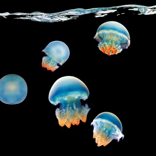
Blue Blubber Jellyfish

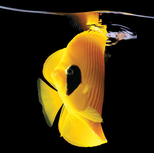
Golden Butterfly

Green Chromis

Humpback Anglerfish

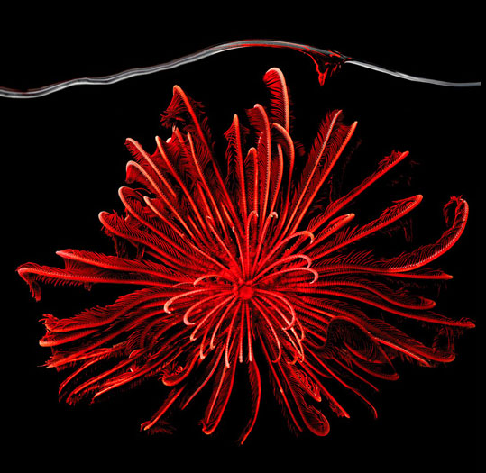
Red Feather Starfish

Blue Spot Stingray

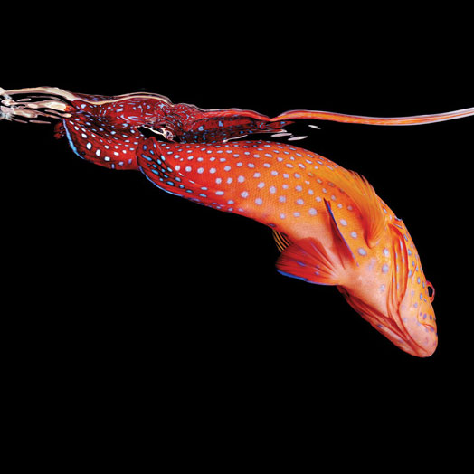
Miniatus Grouper
Full review, along with more images, here.

Thursday, January 20, 2011

Coronary Imaging helps identify cause of heart disease

Results from the PROSPECT clinical trial shed new light on the types of vulnerable plaque that are most likely to cause sudden, unexpected adverse cardiac events, and on the ability to identify them through imaging techniques before they occur.

The trial, Providing Regional Observations to Study Predictors of Events in the Coronary Tree (PROSPECT), is the first prospective natural history study of atherosclerosis using multi-modality imaging to characterize the coronary tree. The study findings were published in the January 20, 2011 issue of the New England Journal of Medicine.

“As a result of the PROSPECT trial, we are closer to being able to predict — and therefore prevent — sudden, unexpected adverse cardiac events,” said principal investigator Gregg W. Stone, MD. Dr. Stone is Professor of Medicine at Columbia University College of Physicians and Surgeons, Director of Cardiovascular Research and Education at the Center for Interventional Vascular Therapy at NewYork-Presbyterian Hospital/Columbia University Medical Center and Co-Director of the Medical Research and Education Division at the Cardiovascular Research Foundation (CRF).

The multi-center trial studied 700 patients with acute coronary syndromes (ACS) using three-vessel multimodality intra-coronary imaging — angiography, grayscale intravascular ultrasound (IVUS), and radiofrequency IVUS — to quantify the clinical event rate due to atherosclerotic progression and to identify those lesions that place patients at risk for unexpected adverse cardiovascular events (sudden death, cardiac arrest, heart attacks and unstable or progressive angina).

Among the discoveries of the trial are that most untreated plaques that cause unexpected heart attacks are not mild lesions, as previously thought, but actually have a large plaque burden and/or a small lumen area. These are characteristics that were invisible to the coronary angiogram but easily identifiable by grayscale IVUS.

Moreover, and perhaps most importantly, for the first time it was demonstrated that characterization of the underlying plaque composition (with radiofrequency IVUS, also known as VH-IVUS) was able to significantly improve the ability to predict future adverse events beyond other more standard imaging techniques.

“These results mean that using a combination of imaging modalities, including IVUS to identify lesions with a large plaque burden and/or small lumen area, and VH-IVUS to identify a large necrotic core without a visible cap (a thin cap fibroatheroma) identifies the lesions that are at especially high risk of causing future adverse cardiovascular events,” Dr. Stone said.

Monday, November 29, 2010

New Research: Prostrate Cancer Tumour Imaging

More than 200,000 men are diagnosed with prostate cancer each year and 28,000 die from it, making it one of the most common cancer in men nationwide and also one of the leading causes of cancer death in men, according to the Centres for Disease Control.

Yet the disease ranges widely in its rate of growth and aggressiveness, according to John Kurhanewicz, PhD, a UCSF expert in prostate cancer imaging. As a result, there is great debate over the ideal strategy for treating the disease, he said, leaving patients with a difficult and potentially life-changing decision over how aggressively to respond to the disease.

“This test could give both physicians and patients the information they need to make that decision,” said Kurhanewicz, whose work with Dan Vigneron, PhD, and their colleagues from the UCSF Department of Radiology and Biomedical Imaging first linked a prostate tumour’s production of lactate to tumour aggressiveness. Other researchers also have linked that lactate production to tumour aggressiveness and response to therapy in other cancers.

The method uses compounds involved in normal tissue function — in this case, pyruvate, which is a naturally occurring by-product of glucose, and lactate, also known as lactic acid — and uses newly developed equipment to increase the visibility of those compounds by a factor of 50,000 in a magnetic resonance imaging (MRI) scanner.

That process requires pyruvate to be prepared in a strong magnetic field at a temperature of minus 272O C, then rapidly warmed to body temperature and transferred to the patient in an MRI scanner before the polarisation decays back to its native state.

The result is a highly defined and clear image of the tumour’s outline, as well as a graph of the amount of pyruvate in the tumour and the rate at which the tumour converts the pyruvate into lactate.

The sterile production process requires a dedicated clinical pharmacist with the knowledge of both quality control and of clinical practice.

The procedure must take place within minutes, which meant integrating a clean room into the scanning facility. QB3 also worked with GE Healthcare in designing Byers Hall, in which the Surbeck Laboratory of Advanced Imaging is housed, to accommodate the extremely strong magnetic field of the MRI scanner and enable time-sensitive experiments.

“All of that insight is why we moved this technology to Northern California,” said Jonathan Murray, general manager, Metabolic Imaging at GE Healthcare. “This is a huge accomplishment UCSF and QB3 have achieved.

They brought together the best engineering from UC Berkeley and the best bioscience and pharmacy knowledge from UCSF, and are now demonstrating the technology in a world-renowned academic medical centre.

We are delighted with the speed of progress of this collaboration. The science is very exciting.”

Wednesday, October 7, 2009

Digital Cameras - Gigavision Sensors and the future of Perfect Pictures

HOW can image sensors - the most complicated and expensive part of a digital camera - be made cheaper and less complex? Easy: take the lid off a memory chip and use that instead.

As simple as it sounds, that pretty much sums up a device being developed by a team led by Edoardo Charbon, an engineer at the Swiss Federal Polytechnic Institute (EPFL) in Lausanne.

Gigavision
In a paper presented at an imaging conference in Kyoto, Japan, this week, the team say that their so-called "gigavision" sensor will pave the way for cellphones and other inexpensive gadgets that take richer, more pleasing pictures than today's devices. Crucially, Charbon says the device performs better in both very bright light and dim light - conditions which regular digital cameras struggle to cope with.

An Established Principle
While Charbon's idea is new and has a patent pending, the principle behind it is not. It has long been known that memory chips are extremely sensitive to light: remove their black plastic packages to let in light, and the onrush of photons energises electrons, creating a current in each memory cell that overwhelms the tiny stored charge that might have represented digital information. "Light simply destroys the information," says Martin Vetterli, a member of the EPFL team.

A similar effect occurs aboard spacecraft: when energetic cosmic rays hit a cell in an unprotected memory chip they can "flip" the state of the cell, corrupting the data stored in the chip.

What Charbon and his team have found is that when they carefully focus light arriving on an exposed memory chip, the charge stored in every cell corresponds to whether that cell is in a light or dark area. The chip is in effect storing a digital image.

To what effect?
All very clever, you might say, but why would anyone want to do that? The answer is that the two types of sensor chips used in today's digital cameras store the brightness of each pixel as an analogue signal. To translate this into a form that can be stored digitally, they need complex, bulky, noise-inducing circuitry.

CCD Sensors
The charge-coupled device (CCD) sensors used on early cameras and camcorders, and the cheaper and more modern complementary metal oxide semiconductor (CMOS) type both operate on a similar principle. On each, the area that forms an individual pixel can be thought of as a small charge-containing "bucket". The size of the charge contained in one of these buckets depends only on the amount of light falling on it.

Analogue to Digital
In a CCD, the contents of each bucket of charge are "poured" into the bucket next door, and then the next until the signal reaches the edge of the chip. There, an analogue-to-digital converter (ADC) typically assigns it an 8-bit greyscale value, ranging from 0 to 255. In a CMOS sensor, the charge is converted to a voltage local to each pixel before being shunted off to an ADC at the edge of the chip - where it too is assigned a greyscale value between 0 and 255 (see diagram).

CMOS Sensors
A memory chip needs none of this conversion circuitry, as it creates digital data directly. As a result, says Vetterli, the memory cell will always be 100 times smaller than CMOS sensor cells; it is bound to be that way because of the sheer number of signal-conditioning transistors the CMOS sensor needs around each pixel. "Our technology will always be two orders of magnitude smaller," he says.

So for every pixel on one of today's sensors, the memory-based sensor could have 100 pixels. A chip the size of a 10-megapixel camera sensor will have 100 times as many sensing cells if implemented in memory technology - hence the choice of the gigavision name.