Showing posts with label ocean. Show all posts

Tuesday, September 30, 2014

Europe's SSTL new ocean winds and waves measuring method - video


The video shows in about 20 times real time speed the motion of the TechDemoSat-1 satellite over an orbit, indicated by a white cross on the world map. 

The specular reflections targeted by the SGR-ReSI are shown by yellow spots, and the measurement tracks are shown in yellow. 

The four Delay Doppler Map channels from the SGR-ReSI are shown at the top right. The spreading horseshoe shape is caused by reflections being received away from the specular point, and a rougher ocean causes more spreading. 

When reflections are received from over land and over ice, there is much less spreading. 

The red band on the map indicates the collection of “raw” unprocessed data, which takes a few minutes to transfer before the processed Delay Doppler Maps resume.

Credit: SSTL

Surrey Satellite Technology Ltd (SSTL) has successfully demonstrated an innovative method of measuring winds and waves from space, using GNSS Reflectometry.

This paves the way for a cost effective satellite system supporting the maritime sector and the organisations that rely on this information and it also offers improvements to weather services and climate research.

The measurements were taken from an instrument developed by SSTL, the SGR-ReSI, (Space GNSS Receiver Remote Sensing Instrument) which is flying on-board TechDemoSat-1, a technology demonstration satellite which was launched in July 2014.

TechDemoSat-1
SSTL's SGR-ReSI collects the signals from GPS and other navigation satellites after they have been reflected off the ocean surface and processes them into images called Delay Doppler Maps, from which ocean roughness and wind speed measurements at the sea surface can be interpreted.

The technique works in a similar way to existing scatterometric radar from satellites, however it eliminates the need for a transmitter and can process up to four reflections from different GPS satellites simultaneously, presenting an opportunity for collecting data more regularly and in a denser grid across the globe.

By flying the receivers on a constellation of small satellites GNSS Reflectometry data could be used to map all of the Earth's ocean surface with refreshed data every couple of hours.

This would be of enormous benefit to the maritime industry who depend on wave height and wind speed predictions for optimum ship routing, insurance claims, oil and gas rig operations, undersea cable laying and fishing conditions.

Such wind speed and wave height measurements are currently very difficult to make over the open ocean in timely manner and in a dense enough grid to be useful.

Luis Gomes, Director of Earth Observation and Science at SSTL, commented: "We are very excited about the future application of this development which extends the applications of small satellites.

"For instance, a constellation of 18 SGR-ReSIs could cover most of the world's oceans every few hours providing a real time wind and wave height service."

"These do not need to be dedicated satellites as the SGR-ReSI can be easily accommodated as a hosted payload on small satellites with a different primary mission. Our aim is to deploy such a constellation in the next two years."

The SGR-ReSI can pick up GPS reflections not only off the ocean, but also off land, snow and ice, opening up other potential new opportunities for remote sensing - for example, measuring the thickness of sea ice, snow depth, soil moisture levels and the classification of vegetative foliage.

SSTL, supported by the European Space Agency, is now working on preparing the ground processing and web interface that will allow users access to the measurements over the internet with a short delay.

Thursday, July 3, 2014

NASA Cassini: Titan's Icy Ocean has extra high salt content

Researchers found that Titan's ice shell, which overlies a very salty ocean, varies in thickness around the moon, suggesting the crust is in the process of becoming rigid. 

Credit: NASA /JPL /SSI /Univ. of Arizona /G. Mitri /University of Nantes

Scientists analyzing data from NASA Cassini mission have firm evidence the ocean inside Saturn's largest moon, Titan, might be as salty as the Earth's Dead Sea.

The new results come from a study of gravity and topography data collected during Cassini's repeated flybys of Titan during the past 10 years.

Using the Cassini data, researchers presented a model structure for Titan, resulting in an improved understanding of the structure of the moon's outer ice shell.

The findings are published in this week's edition of the journal Icarus.

"Titan continues to prove itself as an endlessly fascinating world, and with our long-lived Cassini spacecraft, we're unlocking new mysteries as fast as we solve old ones," said Linda Spilker, Cassini project scientist at NASA's Jet Propulsion Laboratory (JPL) in Pasadena, California, who was not involved in the study.

Additional findings support previous indications the moon's icy shell is rigid and in the process of freezing solid.

Researchers found that a relatively high density was required for Titan's ocean in order to explain the gravity data.

This indicates the ocean is probably an extremely salty brine of water mixed with dissolved salts likely composed of sulphur, sodium and potassium.

The density indicated for this brine would give the ocean a salt content roughly equal to the saltiest bodies of water on Earth.

"This is an extremely salty ocean by Earth standards," said the paper's lead author, Giuseppe Mitri of the University of Nantes in France.

"Knowing this may change the way we view this ocean as a possible abode for present-day life, but conditions might have been very different there in the past."

Cassini data also indicate the thickness of Titan's ice crust varies slightly from place to place.

The researchers said this can best be explained if the moon's outer shell is stiff, as would be the case if the ocean were slowly crystalizing, and turning to ice.

Otherwise, the moon's shape would tend to even itself out over time, like warm candle wax.

This freezing process would have important implications for the habitability of Titan's ocean, as it would limit the ability of materials to exchange between the surface and the ocean.

A further consequence of a rigid ice shell, according to the study, is any outgassing of methane into Titan's atmosphere must happen at scattered "hot spots," like the hot spot on Earth that gave rise to the Hawaiian Island chain.

Titan's methane does not appear to result from convection or plate tectonics recycling its ice shell.

How methane gets into the moon's atmosphere has long been of great interest to researchers, as molecules of this gas are broken apart by sunlight on short geological timescales.

Titan's present atmosphere contains about five percent methane. This means some process, thought to be geological in nature, must be replenishing the gas.

The study indicates that whatever process is responsible, the restoration of Titan's methane is localized and intermittent.

"Our work suggests looking for signs of methane outgassing will be difficult with Cassini, and may require a future mission that can find localized methane sources," said Jonathan Lunine, a scientist on the Cassini mission at Cornell University, Ithaca, New York, and one of the paper's co-authors. "As on Mars, this is a challenging task."

More information: Icarus, www.sciencedirect.com/science/… ii/S0019103514001444

Tuesday, April 15, 2014

Pluto: Three possible models of Dwarf Planet ahead of New Horizons visit

Interior structure models assumed for Pluto.

Two space researchers, Amy Barr, with Brown University and Geoffrey Collins with Wheaton College, have published a paper in the journal Icarus in which they describe three possible interior models of the former planet Pluto.

They suggest the possibilities include: 
  1. an undifferentiated rock/ice mixture, 
  2. a differentiated rock/ice mixture, and an ocean covered with ice. 
  3. The third possibility suggests the likelihood, they claim, of tectonic action on the dwarf planet.

Pluto
A close up view of the planet by space probe New Horizons due to arrive next year, should help clarify which scenario is most likely.

Amy Barr
Scientists believe that Pluto came to exist as it does today, in part due to a collision billions of years ago that led also to the formation of its moon Charon.

Charon
When celestial bodies collide, not only do they knock each other around, they produce heat—heat, the researchers suggest that could still be evident today.

Barr and Collins are leading towards a theory that suggests that shortly after impact, Pluto and Charon were much closer together, the gravity attraction between them would have caused both to be egg shaped.

As time passed, melted ice from the impact would have created an icy crust on top of an ocean on Pluto, and then, as Charon moved farther away, the attractive pull would have diminished, causing ice plates to form and crack against one another, a form of tectonics.

Geoffrey Collins
If that were the case, the two add, then in all likelihood, when New Horizons begins sending back images, they should see evidence of such tectonic action—plate edges thrust into the air, for example.

There's just one catch, Pluto circles the sun in an elliptical orbit, thus sometimes it's much closer to the sun than other times.

When near, it has a defined atmosphere, when far away however, its atmosphere actually freezes to its surface, something that could hide ridges in the ice and thus evidence of both tectonic activity and an ocean beneath the crust of ice.

New Horizons
Artist concept of New Horizons spacecraft.

Johns Hopkins University Applied Physics Laboratory (JHUAPL) 
/Southwest Research Institute (SwRI)

Since New Horizons will arrive during a time when its atmosphere is frozen to the surface, it might be difficult to determine which of the three proposed models actually describes the relationship between its exterior and interior.

Barr and Collins are optimistic that even in such a scenario, ridges should be apparent, proving that beneath Pluto's icy surface, lies an ocean, one that future researchers might one day sample.

More information: Tectonic Activity on Pluto After the Charon-Forming Impact, Icarus, Available online 4 April 2014. dx.doi.org/10.1016/j.icarus.2014.03.042 . Available on Arxiv: xxx.lanl.gov/abs/1403.6377

Saturday, April 5, 2014

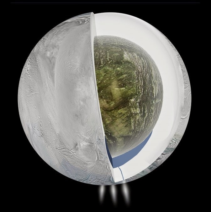
NASA Cassini: Ocean inside Saturn's Icy Moon, Enceladus

Gravity measurements by NASA's Cassini spacecraft and Deep Space Network suggest that Saturn's moon Enceladus, which has jets of water vapor and ice gushing from its south pole, also harbours a large interior ocean beneath an ice shell, as this illustration depicts.

Image Credit: NASA/JPL-Caltech

NASA's Cassini spacecraft and Deep Space Network have uncovered evidence Saturn's moon Enceladus harbors a large underground ocean of liquid water, furthering scientific interest in the moon as a potential home to extraterrestrial microbes.

Researchers theorized the presence of an interior reservoir of water in 2005 when Cassini discovered water vapor and ice spewing from vents near the moon's south pole.

The new data provide the first geophysical measurements of the internal structure of Enceladus, consistent with the existence of a hidden ocean inside the moon.

Findings from the gravity measurements are in the Friday April 4 edition of the journal Science.

"The way we deduce gravity variations is a concept in physics called the Doppler Effect, the same principle used with a speed-measuring radar gun," said Sami Asmar of NASA's Jet Propulsion Laboratory (JPL) in Pasadena, Calif., a coauthor of the paper.

"As the spacecraft flies by Enceladus, its velocity is perturbed by an amount that depends on variations in the gravity field that we're trying to measure. We see the change in velocity as a change in radio frequency, received at our ground stations here all the way across the solar system."

The gravity measurements suggest a large, possibly regional, ocean about 6 miles (10 kilometers) deep, beneath an ice shell about 19 to 25 miles (30 to 40 kilometers) thick.

The subsurface ocean evidence supports the inclusion of Enceladus among the most likely places in our solar system to host microbial life.

Before Cassini reached Saturn in July 2004, no version of that short list included this icy moon, barely 300 miles (500 kilometers) in diameter.

"This then provides one possible story to explain why water is gushing out of these fractures we see at the south pole," said David Stevenson of the California Institute of Technology, Pasadena, one of the paper's co-authors.

Cassini has flown near Enceladus 19 times. Three flybys, from 2010 to 2012, yielded precise trajectory measurements.

The gravitational tug of a planetary body, such as Enceladus, alters a spacecraft's flight path.

Variations in the gravity field, such as those caused by mountains on the surface or differences in underground composition, can be detected as changes in the spacecraft's velocity, measured from Earth.

The technique of analyzing a radio signal between Cassini and the Deep Space Network can detect changes in velocity as small as less than one foot per hour (90 microns per second).

With this precision, the flyby data yielded evidence of a zone inside the southern end of the moon with higher density than other portions of the interior.

The south pole area has a surface depression that causes a dip in the local tug of gravity. However, the magnitude of the dip is less than expected given the size of the depression, leading researchers to conclude the depression's effect is partially offset by a high-density feature in the region, beneath the surface.

"The Cassini gravity measurements show a negative gravity anomaly at the south pole that however is not as large as expected from the deep depression detected by the onboard camera," said the paper's lead author, Luciano Iess of Sapienza University of Rome.

"Hence the conclusion that there must be a denser material at depth that compensates the missing mass: very likely liquid water, which is seven percent denser than ice. The magnitude of the anomaly gave us the size of the water reservoir."

There is no certainty the subsurface ocean supplies the water plume spraying out of surface fractures near the south pole of Enceladus, however, scientists reason it is a real possibility.

The fractures may lead down to a part of the moon that is tidally heated by the moon's repeated flexing, as it follows an eccentric orbit around Saturn.

Much of the excitement about the Cassini mission's discovery of the Enceladus water plume stems from the possibility that it originates from a wet environment that could be a favorable environment for microbial life.

"Material from Enceladus’ south polar jets contains salty water and organic molecules, the basic chemical ingredients for life," said Linda Spilker, Cassini's project scientist at JPL.

"Their discovery expanded our view of the 'habitable zone' within our solar system and in planetary systems of other stars. This new validation that an ocean of water underlies the jets furthers understanding about this intriguing environment."

The Cassini-Huygens mission is a cooperative project of NASA, the European Space Agency and the Italian Space Agency.

Ocean Discovery On Enceladus Spur Life-Hunting Missions to Icy Moons

Saturn's moon Enceladus, covered in snow and ice, resembles a perfectly packed snowball in this image from NASA's Cassini mission released on Dec. 23, 2013.

This view was taken by Cassini on March 10, 2012. It shows the leading side of Enceladus

North on Enceladus is up and rotated 6 degrees to the left.

Credit: NASA/JPL-Caltech/Space Science Institute

Astronomers are hoping that the existence of a subsurface ocean on Saturn's icy moon Enceladus will build momentum for life-hunting missions to the outer solar system.

Researchers announced their discovery of the deep watery ocean on Enceladus on Thursday (April 3) in the journal Science, confirming suspicions held by many scientists since 2005, when NASA's Cassini spacecraft spied geysers of ice and water vapor erupting from Enceladus' south pole.

The discovery vaults Enceladus into the top tier of life-hosting candidates along with Europa, an ice-sheathed moon of Jupiter that also hosts a subterranean ocean. Both frigid satellites bear much closer investigation, researchers say.


"I don't know which of the two is going to be more likely to have life. It might be both; it could be neither," study co-author Jonathan Lunine of Cornell University told reporters yesterday (April 2).

Jonathan Lunine
"I think what this discovery tells us is that we just need to be more aggressive in getting the next generation of spacecraft both to Europa and to the Saturn system once the Cassini mission is over."

Cassini arrived in orbit around Saturn in 2004 and is currently scheduled to go out in a blaze of glory in September 2017, when it will dive headlong into the giant planet's thick atmosphere.

Enceladus' geysers blast material hundreds of miles into space, offering a way to sample the moon's subsurface ocean from afar.

(Researchers think the ocean is feeding the geysers, though they can't be sure of this at the moment.)

Saturday, February 22, 2014

NASA ORION Space capsule: Recovery test in ocean suspended after issue

This Wednesday, Feb. 19, 2014 photo released by NASA shows crews testing a test version of Orion's forward bay cover, NASA's next-generation space capsule. 

NASA and the Navy suspended the test Thursday, Feb. 20, 2014 off the coast of San Diego after a problem was discovered. 

AP Photo/NASA

A training exercise designed to showcase the government's ability to recover a space capsule at sea was scrubbed after NASA ran into trouble off the Southern California coast, the space agency said Friday.

Crews had difficulty tying down a mock-up of the Orion capsule aboard an amphibious warship off the shores of San Diego.

NASA said cables attached to the capsule weren't strong enough to handle turbulence and snapped off twice while it was in the well deck of the USS San Diego before it could be moved out to sea on Thursday.

With the Orion mock-up still on the Navy ship, teams could not practice fetching the spacecraft from the ocean.

"Even though the testing didn't go as we had planned, we're learning lessons that will help us be better prepared to retrieve Orion," Bill Hill of NASA headquarters said in a statement.

Engineers were troubleshooting the problem, and it was not clear when the test would be rescheduled.

NASA has been developing a next-generation spacecraft to carry astronauts beyond low-Earth orbit, possibly to an asteroid or Mars.

Orion, which will make its first unmanned test flight this fall, is being designed to travel to deep space and return at speeds of 25,000 mph (40,232 kph) by splashing down into the Pacific.

This Wednesday Feb. 19, 2014 photo released by NASA shows a test version of the Orion spacecraft, tethered inside the well deck of the USS San Diego prior to testing between NASA and the U.S. Navy. 

NASA and the Navy suspended the test Thursday, Feb. 20, 2014 off the coast of San Diego after a problem was discovered. AP Photo/NASA

The water landing is a throwback to the 1960s and 1970s when Navy ships routinely tracked and recovered Mercury, Gemini and Apollo spacecraft after re-entering Earth's atmosphere.

With the space shuttle fleet retired, NASA has decided to go with an ocean splashdown.

Unlike in the past, when helicopters would hoist astronauts after a mission, the new plan calls for an amphibious transport ship to dispatch divers and small boat teams to recover Orion and its crew.

Last year, NASA and the Navy practiced recovering the Orion in the calm waters of the Elizabeth River in Virginia with no problem.

Before the latest test was called off, NASA said crews successfully retrieved parts of the spacecraft, including the parachute and a protective covering.

NASA Administrator Charles Bolden was supposed to visit the test site Saturday, but his appearance was cancelled.

Thursday, April 26, 2012

ESA's Latest CryoSat results revealed

After nearly a year and a half of operations, CryoSat has yielded its first seasonal variation map of Arctic sea-ice thickness. 

Results from ESA's ice mission were presented at the Royal Society in London. In June 2011, the first map of Arctic sea-ice thickness was unveiled, using CryoSat data acquired between January and February of that year.

Now, the complete 2010-11 winter season data have been processed to produce a seasonal variation map of sea-ice thickness.

This is the first map of its kind generated using data from a radar altimeter at such a high resolution compared to previous satellite measurements.

CryoSat's altimeter makes precise measurements of its height above the ice by measuring the time interval between the transmission and reception of very short radar pulses.

Readings over the Arctic from October 2010 to March 2011 were processed to map the seasonal formation of floating ice.

ESA and NASA have been collaborating to perform carefully coordinated flights directly under CryoSat's orbit over the Arctic, gathering data to ensure the accuracy of the satellite measurements.

This first validated CryoSat dataset demonstrates the full potential of this innovative ice mission.

Owing to the high rate of change in the Arctic Ocean, this has a special relevance for climate change research.

Other significant results from this collaborative European mission will be presented and discussed, with perspectives from UK industrial and scientific communities.

This event is being jointly organised by ESA and the UK Space Agency as part of the wider celebration of the 50th anniversary of the UK in space.

The map, along with a full digital elevation model of Greenland and other scientific results from the collaborative European mission, were presented at the Royal Society in London.

The event was jointly organised by ESA and the UK Space Agency as part of the wider celebration of the 50th anniversary of the UK in space.

"Within the 50th anniversary celebrations of space activities in the UK, we have seen how the UK has been able to contribute to and lead in the many aspects of ESA's CryoSat mission," said David Williams, Chief Executive of the UK Space Agency.

Director of ESA's Earth Observation Programmes, Volker Liebig, outlined the dramatic effects that climate change has had on the Arctic, and how satellites have been monitoring sea-ice for over 30 years.

"In the coming years, the Arctic will become a very important geo-political region," said Prof. Liebig.

"15 to 20 per cent of the world's oil and gas reserves are expected there, and we will find shorter shipping routes as the ice melts. Satellites will play and ever-important role in the sustainable management of this sensitive region."


Every year, the Arctic Ocean experiences the seasonal formation and then melting of vast amounts of floating ice. Over the past decade, satellites have seen an acceleration in the rate of overall sea ice loss.

Radars on satellites such as ESA's CryoSat can acquire high-resolution images through clouds and darkness. This is particularly useful when observing the inaccessible Arctic, which is prone to long periods of bad weather and extended darkness.

In the coming years, CryoSat data will map precise changes in sea-ice thickness year to year, furthering our understanding of the effects that climate change has on the Arctic.

ESA's SMOS mission is providing complementary information on sea-ice cover and the thickness of thin ice.

Thursday, March 29, 2012

Amazon Founder Finds Apollo 11 Moon Rocket Engines On Atlantic Ocean Floor

This NASA file photo shows the first stage of the mighty Saturn V rocket used to launch the historic Apollo 11 moon landing mission in 1969 as the booster was being built. The five huge F-1 rocket engines were discarded into the Atlantic Ocean after the July 16, 1969 launch.
CREDIT: NASA

When NASA's mighty Saturn V rocket launched the historic Apollo 11 mission to land the first men on the moon in 1969, the five powerful engines that powered the booster's first stage dropped into the Atlantic Ocean and were lost forever.

Lost, that is, until now.

A private expedition financed by Amazon.com founder and billionaire Jeff Bezos has discovered the five F-1 rocket engines used to launch Apollo 11 into space on July 16, 1969 and is drawing up plans to retrieve one or more so they can be publicly displayed.

"I'm excited to report that, using state-of-the-art deep sea sonar, the team has found the Apollo 11 engines lying 14,000 feet below the surface, and we're making plans to attempt to raise one or more of them from the ocean floor," Bezos wrote in a statement posted to the Bezos Expeditions website.

"We don't know yet what condition these engines might be in - they hit the ocean at high velocity and have been in salt water for more than 40 years. On the other hand, they're made of tough stuff, so we'll see."

Wednesday, March 21, 2012

Seafloor Mountain Expedition Studied Crust's Deepest Layer


A topographical map of the Atlantis Massif, which also shows the location of its Lost City hydrothermal vents.
CREDIT: NOAA.

Scientists recently returned from an expedition to an unusual seafloor mountain, where they conducted what may be the first-ever on-site study of a type of rock that makes up a huge amount of our planet, but is largely out of reach.

Researchers aboard the research vessel JOIDES Resolution sent instruments to the Atlantis Massif, a seamount that lies near the Mid-Atlantic Ridge, a long volcanic rift bisecting the Atlantic Ocean, where two tectonic plates are being slowly shoved apart and fresh oceanic crust is created.

Seamounts are essentially a mountain that doesn't rise above the ocean's surface.

Unlike most seamounts, which are typically made of volcanic rock, geological forces essentially yanked the Atlantis Massif from the Earth's gabbroic layer — the deepest layer of the Earth's crust, which rests directly on the planet's ever-shifting mantle.

Saturday, February 4, 2012

Saviour of the Coral Reefs: Sea Cucumbers

Sea cucumbers can save coral reefs from the impact of ocean acidification on their growth, a group of scientists working on the impact of climate change on coral reefs have revealed in a recent study.

The research, published in the latest issue of the Journal of Geophysical Research, suggests that calcium carbonate released from the digestion of sand by sea cucumbers, one of the largest invertebrates found on tropical reefs, is a key component for the survival of coral reefs.

Maria Byrne, professor and director, One Tree Island Research Station of the University of Sydney on the Great Barrier Reef, said that coral reefs must accumulate CaCO3 at a rate greater than or equal to the CaCO3 that is eroded from the reef to survive.

Byrne, who is the lead author of the research, writes in the journal: "The research at One Tree Island showed that in a healthy reef, dissolution of calcium carbonate sediment by sea cucumbers and other bio-eroders appears to be an important component of the natural calcium carbonate turnover."

Wednesday, January 11, 2012

The World Islands project in Dubai

A development is seen on one of the islands of The World Islands project in Dubai.

Picture: REUTERS/Jumana El Heloueh

New Volcanic Island forms in Red Sea

A new island is forming in the Red Sea. About 60 kilometres (40 miles) from the coast of Yemen, an undersea eruption began in mid-December 2011.

This satellite image suggests that the eruption has risen nearly completely above water.

A plume of steam, other volcanic gases, and ash spews from a distinct cone. The land surrounding the vent has grown, and is now about 530 by 710 metres (1,700 by 2,300 feet) across.

In contrast to the fragmented rock that forms when lava interacts directly with water, lava that solidifies on land is tough, so this new island is likely to stick around.

Picture: NASA / AFP/Getty

Monday, October 10, 2011

Lair of the Giant Kraken Discovered

Long before whales, the oceans of Earth were roamed by a very different kind of air-breathing leviathan.

Snaggle-toothed ichthyosaurs larger than school buses swam at the top of the Triassic Period ocean food chain, or so it seemed before Mount Holyoke College paleontologist Mark McMenamin took a look at some of their remains in Nevada.

Now he thinks there was an even larger and more cunning sea monster that preyed on ichthyosaurs: a kraken of such mythological proportions it would have sent Captain Nemo running for dry land.

McMenamin will be presenting the results of his work on Monday, 10 October at the annual meeting of the Geological Society of America in Minneapolis.

The evidence is at Berlin-Ichthyosaur State Park in Nevada, where McMenamin and his daughter spent a few days this summer.

It’s a site where the remains of nine 45-foot (14-meter) ichthyosaurs, of the species Shonisaurus popularis can be found.

These were the Triassic’s counterpart to today’s predatory giant squid-eating sperm whales. But the fossils at the Nevada site have a long history of perplexing researchers, including the world’s expert on the site: the late Charles Lewis Camp of U.C. Berkeley.

“Charles Camp puzzled over these fossils in the 1950s,” said McMenamin. “In his papers he keeps referring to how peculiar this site is. We agree, it is peculiar.”

Camp’s interpretation was that the fossils probably represented death by an accidental stranding or from a toxic plankton bloom.

But no one had ever been able to prove that the beasts died in shallow water. In fact more recent work on the rocks around the fossils suggest it was a deep water environment, which makes neatly arranged carcasses even more mysterious.

This question — shallow or deep ocean death — is what attracted McMenamin to the site.

“I was aware that anytime there is controversy about depth, there is probably something interesting going on,” McMenamin said. And when they arrived at the remote state park and started looking at the fossils, McMenamin was struck by their strangeness.

“It became very clear that something very odd was going on there,” said McMenamin. “It was a very odd configuration of bones.”

First of all, the different degrees of etching on the bones suggested that the shonisaurs were not all killed and buried at the same time. It also looked like the bones had been purposefully rearranged.

That got him thinking about a particular modern predator that is known for just this sort of intelligent manipulation of bones.

“Modern day octopus will do this,” McMenamin said. What if there was an ancient, very large sort of octopus, like the kraken of mythology. “I think that these things were captured by the kraken and taken to the midden and the cephalopod would take them apart.”

In the fossil bed, some of the shonisaur vertebral disks are arranged in curious linear patterns with almost geometric regularity, McMenamin explained.

The proposed Triassic kraken, which could have been the most intelligent invertebrate ever, arranged the vertebral discs in double line patterns, with individual pieces nesting in a fitted fashion as if they were part of a puzzle.

Even more creepy: The arranged vertebrae resemble the pattern of sucker discs on a cephalopod tentacle, with each vertebra strongly resembling a coleoid sucker. In other words, the vertebral disc “pavement” seen at the state park may represent the earliest known self portrait, by a cephalopod.

Lair of the Giant Kraken Discovered

Wednesday, September 7, 2011

Giant Red Crabs invade the Antartic Abyss


Huge crabs more than a metre across have invaded the Antarctic abyss, wiped out the local wildlife and now threaten to ruin ecosystems that have evolved over 14 million years.

Three years ago, researchers predicted that as the deep waters of the Southern Ocean warmed, king crabs would invade Antarctica within 100 years.

But video taken by a remotely operated submersible shows that more than a million Neolithodes yaldwyni have already colonised Palmer Deep, a basin that forms a hollow in the Antarctic Peninsula continental shelf.

They are laying waste to the landscape. Video footage taken by the submersible shows how the crabs prod, probe, gash and puncture delicate sediments with the tips of their long legs.

"This is likely to alter sediment processes, such as the rate at which organic matter is buried, which will affect the diversity of animal communities living in the sediments," says Craig Smith of the University of Hawaii at Manoa, whose team discovered the scarlet invaders.

Hungry invaders

The crabs also appear to have a voracious appetite. Echinoderms – sea urchins, sea lilies, sea cucumbers, starfish and brittle stars – have vanished from occupied areas, and the number of species in colonised areas is just a quarter of that in areas that have escaped the invasion.

"[Echinoderms] constitute a significant proportion of the large animals on the seafloor in many Antarctic shelf habitats," says Smith.

The crabs come from further north and moved in as Antarctic waters have warmed, probably swept into Palmer Deep as larvae in warm ocean currents. 

They now occupy the deepest regions of Palmer Deep, between 1400 and 950 metres. In 1982, the minimum temperature there was 1.2 °C – too cold for king crabs – but by last year it had risen to a balmier 1.47 °C.

Melting ice sheets tend to make shallower waters in Antarctica cooler than deeper ones. There were no king crabs at depths of 850 metres or less, suggesting that these waters are still too cold for them. But with waters warming so rapidly, they could spread to regions as shallow as 400 metres within as little as 20 years, says Smith.

Friday, April 1, 2011

NASA Aquarius: SAC-D Artist's Concept

Artist's concept of the Aquarius/SAC-D spacecraft, a collaboration between NASA and Argentina's space agency, with participation from Brazil, Canada, France and Italy.

Aquarius, the NASA-built primary instrument on the spacecraft, will take NASA's first space-based measurements of ocean surface salinity, a key missing variable in satellite observations of Earth that links ocean circulation, the global balance of freshwater and climate.

The mission is scheduled to launch in June.


Technicians lower the cover over the shipping container holding the international Aquarius/SAC-D spacecraft at Brazil's National Institute for Space Research in Sáo José dos Campos, in preparation for its transport to California's Vandenberg Air Force Base for launch this June.

Images credit: NASA

Further information on the NASA Aquarius program

Tuesday, March 8, 2011

Research explains mystery of ocean sediment

A discovery, made by a team of scientists from the UK and US, helps explain the origins of a key component of marine sediments, fine-grained carbonates, the origins of which are often problematic to resolve.

Published in The Proceedings of the National Academy of Science (PNAS), the study describes the discovery of an entirely new source of marine carbonate and one that has major implications for understanding the origins of the sediments that form ancient limestone and chalk deposits.

Until now it was believed that the fine-grained carbonates that constitute a major component of marine carbonate sediments were derived primarily from either direct precipitation out of seawater or from the breakdown of the skeletons of marine invertebrates and algae.

This study, funded by the UK's Natural Environment Research Council (NERC), shows that large volumes of carbonate crystals are precipitated inside the intestines of marine fish and are then excreted at very high rates, releasing this lesser-known, non-skeletal carbonate into the marine environment.

Although this material comes from the guts of marine fish, it is derived from calcium in the seawater they drink rather than any undigested product of their food.

However, the form and fate of these crystals after excretion by the fish was unknown. The researchers therefore conducted a "needle in a haystack" search, to look for microscopic crystals that are unique to fish within areas that are already rich in carbonate crystals from other organisms.

The study was undertaken in The Bahamas, famous for its white carbonate sands and muds, where the preservation of such crystals in shallow sediments was predicted to be good.

Measurements made on fish that were local to The Bahamas yielded conservative estimates that they produce in excess of 6 million kg of carbonate each year across the region, equivalent to an estimated 14% of its total carbonate mud production.

Friday, June 18, 2010

NASA MODIS Image: Chaiten Volcano, Chile from space


Chile: An image taken on May 5 2008 by the NASA MODIS programme shows a cloud-like plume of ash and steam rising from the Chaiten volcano in Chile, drifting across Argentina and over the Atlantic Ocean

Picture: AFP/NASA