Showing posts with label pictures. Show all posts

Thursday, November 13, 2014

ESA Rosetta team broadcast new pictures from Philae lander

Prof Jean Pierre Bibring (CNES) ESA Rosetta science team leader at the ESA update broadcast revealing new pictures from Philae lander sitting on the Comet 67/P.

The Philae is sitting close to a rocky cliff like structure, with 2 legs out of three on firm surface. The surface appears to be rocky not powdery.

The instruments on Philae are firing up to gather as much science data as possible while the onboard matteries are running.

Given that the Philae may be sitting on partial shade there is some doubt as to whether the solar panels can be deployed to extend the power cycle of the instruments' data gathering.

Prof Ulamec (DLR) of the ESA Rosetta team shows the approx area (the blue diamond) that the team believe Philae is located, on the comet.

There is some concern that is in the shade of a cliff-like structure.

The ESA team are under great pressure to produce pictures and data from the comet and this is clearly showing up in the professional but sleep deprived presentations.


Short animated sequence showing Philae leaving Rosetta on its descent to Comet 67/P.

This image from Rosetta shows a tiny dot that is the Philae lander in transit to comet 67/P. 


This is a composite picture made up of the others (above) showing an almost panaramic view around Philae.

Saturday, November 1, 2014

Virgin Galactic crash: last moments of SpaceShipTwo

This is the moment Virgin Galactic's SpaceShipTwo rocket exploded in the air during a test flight, killing one pilot and seriously injuring another.

The rocket belonging to hedonist billionaire Sir Richard Branson's space tourism venture exploded in a fireball during a test flight before crashing in the Mojave Desert in California.

A Virgin Galactic spokesman said the rocket "suffered a serious anomaly" after a test flight conducted by partner business Scaled Composites.

One eyewitness to the event, Doug Messier, managing editor of Parabolicarc.com, saw SpaceShipTwo's engine sputter when it first came to life during the test flight, after WhiteKnightTwo released it.

"It looked like the engine didn't perform properly," Messier told Space.com's Tariq Malik. "Normally it would burn and it would burn for a certain period of time. It looked like it may have started and then stopped and then started again."

Then, Messier saw the ship break apart. "I didn't see an explosion, but it definitely broke into pieces," he added.

Sir Richard wrote on Twitter: "Thoughts with all @virgingalactic & Scaled, thanks for all your messages of support. I'm flying to Mojave immediately to be with the team."

At a press conference in California, Virgin Galactic chief executive George Whitesides said: "Space is hard and today was a tough day.

"We are going to be supporting the investigation as we figure out what happened today. We are going to get through it."

"The future rests in many ways on hard days like this but we believe we owe it to the folks who were flying these vehicles as well as the folks who have been working so hard on them to understand this and to move forward."

He said it was the first time the rocket had been flown using a new fuel formulation.

"It had been proven and tested on the ground many times," he added.

Mr Whitesides said the pilots were employed by Scaled Composites. He added that the injured pilot was "as well as could be expected".

SpaceShipTwo has been under development at Mojave Air and Spaceport .

This venture was not about the advancement of science or for the benefit of humankind. This was a 'for profit' venture.

The pursuit of fame, increased revenues and bottom-line profits by Virgin's hedonistic billionaire figure-head has now led to the premature and terrifying death of one man and crippling injuries and pain of another. 

Friday, March 21, 2014

Starshade: Space sunflower will help snap pictures of planets

The prototype Starshade, a giant structure designed to block the glare of stars so that future space telescopes can take pictures of planets.

A spacecraft that looks like a giant sunflower might one day be used to acquire images of Earth-like rocky planets around nearby stars.

The prototype deployable structure, called a starshade, is being developed by NASA's Jet Propulsion Laboratory in Pasadena, Calif.

The hunt is on for planets that resemble Earth in size, composition and temperature. Rocky planets with just the right temperature for liquid water—not too hot, not too cold—could be possible abodes for life outside our solar system.

NASA's Kepler mission has discovered hundreds of planets orbiting other stars, called exoplanets, some of which are a bit larger than Earth and lie in this comfortable "Goldilocks" zone.

Researchers generally think it's only a matter of time before we find perfect twins of Earth. The next step would be to image and characterise their spectra, or chemical signatures, which provide clear clues about whether those worlds could support life.

The Starshade is designed to help take those pictures of planets by blocking out the overwhelmingly bright light of their stars.

Simply put, the Starshade is analogous to holding your hand up to the sun to block it while taking a picture of somebody.

The proposed Starshade could launch together with a telescope. Once in space, it would separate from the rocket and telescope, unfurl its petals, then move into position to block the light of stars.

Wednesday, February 12, 2014

ISS Expedition 41 Astronaut team pose for pictures

Spaceflight is all about teamwork. ESA astronauts Alexander Gerst and Samantha Cristoforetti pose with their suited Russian colleagues Anton Shkaplerov and Maksim Surayev.

Credit: ESA

From the five space agencies that build and maintain the International Space Station to the mission control centres on Earth and the European (ESA), Japanese (JAXA), American (NASA) and Russian (ROCOSMOS) astronauts who fly to the space laboratory, international cooperation and knowhow is critical for a successful mission.

All four will leave Earth for the International Space Station this year. Alexander and Maxim are first up, on 28 May, while Samantha and Anton have their departure planned for 24 November. They will stay on the orbital outpost for around six months.

The ESA astronauts will support their Russian colleagues as 'third operators' if the cosmonauts venture outside the Space Station in their Orlan spacesuits.


Here they are preparing to train with the airlocks that separate astronauts in the Space Station from the harsh vacuum of outer space. Third operators help the spacewalkers put on and remove their spacesuits.

Alexander and Samantha are obvious choices to help the cosmonauts because they have both trained with the Orlan suit themselves.

All Station astronauts must speak Russian and English.

Alexander's Expedition 41 mission patch is visible below the European Astronaut Corps patch on his flight suit.

Friday, September 7, 2012

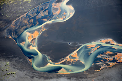
Mountain Water Pictures: Iceland from the Air

"Iceland is a wonderful country; I would even say that it is a true paradise for all the photo shooting-lovers. But what has become a real discovery for me is the bird’s eye view of the rivers flowing along the black volcanic sand. It is an inexpressible combination of colors, lines, and patterns. The photo represents the mouth of the river falling into the ocean."
"A little bit upstream there is a yellow-coloured brook flowing into the river, but yellow currents fail to mix with the main water flow. One can estimate the scale judging by the car tracks that are clearly seen on the black sand. This is just a river, just a volcano, just our planet."
Andre Ermolaev.


Some of the remarkable pictures from Andre Ermolaev’s website

Tuesday, August 28, 2012

Nasa Mars Rover's Curiosity: New Mars HD camera pictures


Get Adobe Flash player

Nasa's Curiosity rover has beamed back yet more astonishing pictures from Mars.

One of the images is a 360-degree view of the landing site, including the highest part of a nearby mountain called Mount Sharp.

Tuesday, March 9, 2010

NASA MODIS: Satellite Pictures of Floods in Spain


By late February 2010, flooding had forced the evacuation of more than 1,000 people in southern Spain, according to the Dartmouth Flood Observatory.

Heavy rains affected the provinces of Cordoba, Jaen, and Seville, blocking roads as well as flooding homes.

The Moderate Resolution Imaging Spectroradiometer (MODIS) on NASA’s Terra satellite captured these images of southern Spain on March 9, 2010 (top), and March 8, 2009 (bottom).

Both images use a combination of infrared and visible light to increase the contrast between water and land. Vegetation appears bright green. Clouds appear sky blue. Water ranges in color from electric blue to navy. Bare ground appears tan.

Much of the flooding in the province of Seville occurred along the Guadalquivir River, which flows past the city of Sevilla (Seville) en route to the Golfo de Cádiz.

Before emptying into the gulf, the river feeds wetlands along the coast, and the most conspicuous difference between the image from March 2010 and the image almost exactly a year earlier is the soggier appearance of these wetlands. Whereas patches of bright green cluster around discrete water bodies in the 2009 image, electric blue—suggestive of standing water—surrounds the deeper water bodies in 2010.

Away from the wetlands, in the direction of Costa del Sol, several water bodies appear swollen in 2010. Overall, the landscape appears greener in the later image, indicating that greater precipitation in 2010 spurred plant growth in the normally arid region.

NASA image courtesy MODIS Rapid Response Team at NASA GSFC. If you wish to see more pictures from the NASA Earth Observatory website click here.

Sunday, January 24, 2010

NASA Mars: HiRISE pictures on request

If you have an absolute favorite spot on Mars, NASA wants to know. The agency may even take a snapshot for you with its most powerful camera circling the red planet.

NASA is taking public suggestions for photo targets on Mars using the HiRISE camera on its Mars Reconnaissance Orbiter. The "HiWish" project, announced Wednesday, allows the general public to choose a location on Mars from a map on the Internet for HiRISE to photograph.

But there's a catch. Merely asking for a photo won't cut it. Requests must be accompanied with a title for the snapshot and a brief explanation of what scientific benefits may come from the Martian photo shoot. Suggestions also need to be categorized in one of the 18 science themes for the camera's mission at Mars.

The highest-priority suggestions will zoom to the top of the list, project organizers said. There is already a backlog of thousands of targets requested by scientists and students waiting for HiRISE to photograph, they added.

"The HiRISE team is pleased to give the public this opportunity to propose imaging targets and share the excitement of seeing your favorite spot on Mars at people-scale resolution," said HiRISE principal investigator Alfred McEwen of the University of Arizona in a statement.

Friday, January 15, 2010

ESA ENVISAT: Haiti Damaga Evaluation Pictures


Damage evaluation map based on satellite data over the Port-au-Prince area of Haiti, following a 7.0 magnitude earthquake and several aftershocks that hit the Caribbean nation on 12 January.
Map based on data from CNES's SPOT-5, JAXA's ALOS and the U.S.-based GeoEye-1 satellites; processed by SERTIT.

Credits: CNES, JAXA, GeoEye, SERTIT

Wednesday, January 13, 2010

NASA MODIS Terra sattelite pictures of the Arctic


A satellite image shows the impact of the negative Arctic Oscillation on land surface temperatures throughout the Northern Hemisphere as observed by MODIS on NASA's Terra satellite during December 2009.
While much of the Northern Hemisphere has shivered in a cold snap in recent weeks, temperatures in the Arctic soared to unusually high levels

Picture: NASA / REUTERS

Friday, November 27, 2009

NASA: Chandra X-ray pictures of the Crab Nebula

The Crab Nebula, one of the most studied objects in the sky. X-ray data from Chandra provide significant clues to the workings of this mighty cosmic "generator," which is producing energy at the rate of 100,000 suns

Picture: AP / NASA

Friday, October 9, 2009

Earth from Space: Typhoon Melor Pictures

This Envisat image captures Typhoon Melor spinning in the Pacific Ocean northeast of the Philippines on 6 October before slamming into the main Japanese island of Honshu on Thursday.
As the typhoon approached Honshu, it was generating winds of 198 km/h, but weakened after making landfall. The strong winds associated with Melor have toppled trees and power lines, leaving some 10 000 homes without electricity.
By early Thursday, the storm was moving northwest at 30 km/h, carrying a maximum sustained wind speed reaching 111 km/h, according to the Japan Meteorological Agency.

Melor is the first typhoon to make landfall in Japan since Typhoon Fitow hit in 2007. Last year was the first time in eight years that a typhoon did not hit the island.

Typhoons and hurricanes are different names for the same kind of storm – a tropical cyclone. If a storm begins in the Atlantic Ocean or the Eastern Pacific Ocean it is called a hurricane, and if it begins in the Western Pacific it is called a typhoon. Typhoons usually pack stronger winds than hurricanes.

Friday, September 4, 2009

NASA: LRO pictures of Apollo 12 landing site

LRO image of Apollo 12 LM descent stage and Surveyor 3

This image from LRO shows the spacecraft's first look at the Apollo 12 landing site. The Intrepid lunar module descent stage, experiment package (ALSEP) and Surveyor 3 spacecraft are all visible. Astronaut footpaths are marked with unlabeled arrows.

This image is 824 meters (about 900 yards) wide. The top of the image faces North. Credit: NASA/Goddard Space Flight Center/Arizona State University