Showing posts with label WHOI. Show all posts

Sunday, November 23, 2014

WHOI NEREUS Robotic Deep-Sea Vehicle Implodes at Hadal depth

Nereus, before its implosion.

Photo Credit: Ken Kostel/Woods Hole Oceanographic Institution

Victor Zykov is director of research at the Schmidt Ocean Institute in Palo Alto, California.

He heads a team developing a remotely operated, full ocean depth robotic vehicle.

They aim to improve on a deep-sea exploration vehicle that imploded this year.

He explains how they aim to build one that's more than a match for the pressure.

Nereus Implodes

It imploded in the Kermadec trench. The formal investigation is still underway, but the preliminary findings suggest that parts of the vehicle meant to maintain atmospheric pressure may have failed.

It was about 10,000 meters down, where the pressures are immense, like having three Humvees stacked on top of one another pressing on a thumbnail and the pressure is applied and released over and over again as the vehicle goes up and down in the water.

That creates stress fatigue and over time small cracks can spread.

Nereus's mission was to undertake high-risk, high-reward research in the deepest parts of Earth's ocean where pressure on the vehicle can be as great as 16,000 pounds per square inch. 

Credit: Advanced Imaging and Visualization Lab, Woods Hole Oceanographic Institution

A Loss to Marine Research

Nereus was the only vehicle active and available to the international scientific community to conduct research in water deeper than 6,000 meters, also known as hadal depths.

There were five projects planned for Nereus; 2014 would have been the first year of really advanced operations, so its loss was a major blow.

Designing an improved version

For buoyancy, instead of ceramics or hollow glass spheres, we plan to use an advanced material called syntactic foam, an epoxy resin with tiny hollow glass microspheres in it.

The latest version of this can survive at depths of 11,000 meters, and even if some of the glass spheres fail under pressure, they don't usually all fail at once.


Also, the camera enclosures will be much smaller, using miniaturized technology deriving from Deepsea Challenger, and will be made of either sapphire or acrylic.

Compared with glass, both materials are more consistent and have more predictable mechanical properties.

Other improvements

As well as a navigation system that will be precise to within 10 meters, even at 11,000 meters down, and better batteries that don't require a hefty pressure protection chamber, the support ship will have a control room with a nearly 180-degree field of view using high-definition screens in positions that match the placement of cameras on the vehicle.

The WHOI team are also installing 3-D video so that the pilot can perceive depth of image, too. They believe this will provide the operators with the best possible illusion of being in the deep ocean, without exposing them to the great risks of diving to hadal depths.

The new vehicle - NEREUS IIk

The current title is N11k, but that is more of a working vehicle designation than a name.

The team anticipate that they will have a competition with input from researchers, students, scientists, and so on to come up with something appropriate.

The plan is to have it ready for ocean trials in early 2016 and for scientific projects later in that year.

Tuesday, November 11, 2014

Fukushima Radiation cesium-134 detected off North American West Coast

Satellite measurements of ocean temperature (illustrated by color) from July 28th to August 4th and the direction of currents (white arrows) help show where radionuclides from Fukushima are transported.  

Large scale currents transport water westward across the Pacific.  Upwelling along the west coast of North America in the summertime brings cold deep water to the surface and transports water offshore.  

Circles indicate the locations where water samples were collected.  

White circles indicate that no cesium-134 was detected.  

Blue circles indicate locations were low levels of cesium-134 were detected.  No cesium-134 has yet been detected along the coast, but low levels have been detected offshore. 

Credit: Woods Hole Oceanographic Institution (WHOI)

Monitoring efforts along the Pacific Coast of the U.S. and Canada have detected the presence of small amounts of radioactivity from the 2011 Fukushima Dai-ichi Nuclear Power Plant accident 100 miles (150 km) due west of Eureka, California.

Scientists at the Woods Hole Oceanographic Institution (WHOI) found the trace amounts of telltale radioactive compounds as part of their ongoing monitoring of natural and human sources of radioactivity in the ocean.

In the aftermath of the 2011 tsunami off Japan, the Fukushima Dai-ichi Nuclear Power Plant released cesium-134 and other radioactive elements into the ocean at unprecedented levels.

Since then, the radioactive plume has traveled west across the Pacific, propelled largely by ocean currents and being diluted along the way.

At their highest near the damaged nuclear power plant in 2011, radioactivity levels peaked at more than 10 million times the levels recently detected near North America.

WHOI marine chemist Ken Buesseler (left) helps two citizen scientists from LUSH Cosmetics gather a water sample in Vancouver, British Columbia, earlier this year. 

Courtesy of Kevin Griffin, WHOI

"We detected cesium-134, a contaminant from Fukushima, off the northern California coast.  The levels are only detectable by sophisticated equipment able to discern minute quantities of radioactivity," said Ken Buesseler, a WHOI marine chemist, who is leading the monitoring effort.

"Most people don't realize that there was already cesium in Pacific waters prior to Fukushima, but only the cesium-137 isotope.  Cesium-137 undergoes radioactive decay with a 30-year half-life and was introduced to the environment during atmospheric weapons testing in the 1950s and '60s."

"Along with cesium-137, we detected cesium-134, which also does not occur naturally in the environment and has a half-life of just two years. Therefore the only source of this cesium-134 in the Pacific today is from Fukushima."

The amount of cesium-134 reported in these new offshore data is less than 2 Becquerels per cubic meter (the number of decay events per second per 260 gallons of water).

This Fukushima-derived cesium is far below where one might expect any measurable risk to human health or marine life, according to international health agencies, and it is more than 1000 times lower than acceptable limits in drinking water set by US EPA.

The offshore radioactivity reported this week came from water samples collected and sent to Buesseler’s lab for analysis in August by a group of volunteers on the research vessel Point Sur sailing between Dutch Harbor, Alaska, and Eureka, California. 

These results confirm prior data described at a scientific meeting in Honolulu in Feb. 2014 by John Smith, a scientist at Fisheries and Oceans Canada in Dartmouth, Nova Scotia, who found similar levels on earlier research cruises off shore of Canada. 

Credit: Curtis Colins

Scientists have used models to predict when and how much cesium-134 from Fukushima would appear off shore of Alaska and the coast of Canada.

They forecast that detectable amounts will move south along the coast of North America and eventually back towards Hawaii, but models differ greatly on when and how much would be found.

Friday, April 11, 2014

WHOI NEREUS: Scientists use ROV to explore Kermadec Trench‎

Researchers will use the deep-submergence vehicle Nereus in their explorations. 

Credit: WHOI

What lives in the deepest part of the ocean, the abyss?

A team of researchers funded by the National Science Foundation (NSF) will use the world's only full-ocean-depth, hybrid, remotely-operated vehicle, Nereus, and other advanced technology to find out.

They will explore the Kermadec Trench at the bottom of the Pacific Ocean.

The trench, located off New Zealand, is the fifth deepest trench in the world. Its maximum depth is 32,963 feet or 6.24 miles (10,047 meters).

It's also one of the coldest trenches due to the inflow of deep waters from Antarctica.

The 40-day expedition to the Kermadec Trench, which begins on April 12, 2014, kicks off a three-year collaborative effort.

The project, known as the Hadal Ecosystem Studies Project (HADES), will conduct the first systematic study of life in ocean trenches, comparing it to the neighbouring abyssal plains, flat areas of the seafloor usually found at depths between 9,843 and 19,685 feet (3,000 and 6,000 meters).

David Garrison
"The proposal to study the deep-sea environment as part of HADES was high-risk, but, we hope, also high-reward," says David Garrison, program director in NSF's Division of Ocean Sciences, which funds HADES.

"Through this exciting project, we will shine a light into the darkness of Earth's deep-ocean trenches, discovering surprising results all along the way."

Among least-explored environments on Earth
A result of extreme pressures in these deep-sea environments and the technical challenges involved in reaching them, ocean trenches remain among the least-explored environments on the planet.

Tim Shank
"We know relatively little about life in ocean trenches, the deepest marine habitats on Earth," says Tim Shank, a biologist at the Woods Hole Oceanographic Institution, one of the participating organizations.

"We didn't have the technology to do these kinds of detailed studies before. This will be a first-order look at community structure, adaptation and evolution: how life exists in the trenches."

NSF HADES principal investigators are Tim Shank, Jeff Drazen of the University of Hawaii and Paul Yancey of Whitman College.

Telepresence technology aboard the NOAA research vessel Thomas G. Thompson will allow the public to share in the discoveries.

Live-streaming Web events from the seafloor will include narration from the science team.

The researchers' work will also be chronicled in video, still images and blog updates on the expedition website.

Monday, January 27, 2014

WHOI Alvin: Deep-diving sub cleared to return to service

Artist's rendition of the newly upgraded Alvin, showing its improved interior layout. 

Credit: E. Paul Oberlander, WHOI

After a three-year overhaul and major upgrade, the United States' deepest-diving research submersible, Alvin, has been cleared to return to work exploring the ocean's depths.

The sub has been out of service since December 2010, undergoing a major upgrade, including the replacement of its personnel sphere with a newly fabricated, larger, more capable hull.

The Woods Hole Oceanographic Institution (WHOI) operates the U.S. Navy-owned sub for the National Deep Submergence Facility on behalf of a consortium of universities and research organizations conducting deep ocean research.

Steven Schulze
On Jan. 8, 2014, the Naval Sea Systems Command's (NAVSEA) Executive Director of Undersea Warfare for the Department of the Navy Steven Schulze certified that the sub could safely operate to depths of 3,800 meters, with the expectation that a certification dive to 4,500 meters will be completed later this year.

"There has been tremendous coordination between the Navy, Woods Hole Oceanographic Institution (WHOI) and the National Science Foundation (NSF) to ensure Alvin's safety and integrity," said the Navy's Director of Advanced Undersea Integration Don Hoffer.

Don Hoffer
"Alvin is a national asset and the Navy is pleased to be a part of the team that returned the vehicle to service."

"Achieving Navy certification is a major milestone in the Alvin upgrade project, enabling the vehicle to get back to its critical mission of taking scientists to the deep sea," said WHOI Vice President for Marine Facilities and Operations Rob Munier.

Rob Munier
"This significant accomplishment is a testament to the rigorous engineering collaboration between WHOI and NAVSEA and the unwavering support of NSF.

Certification helps ensure that Alvin's excellent record of safety will continue for many decades to come."

Alvin carries a pilot and two science observers on missions that last approximately eight hours.

Certification was the final step in Stage I of the Alvin upgrade project, funded by NSF and WHOI.

The upgrade project included; 
  • upgrades to major components for an increased depth rating of 6,500 meters,
  •  including installation of a new, larger personnel sphere with improved interior ergonomics; 
  • five viewports (instead of the previous three) to improve visibility and provide overlapping fields of view; 
  • new lighting and high-definition imaging systems; new syntactic foam for buoyancy and an improved command-and-control system.; 
Upgrades also included improvements to Alvin's launch system and storage hangar onboard its support vessel, the R/V Atlantis.

The Navy certified Alvin using its Deep Submergence Scope of Certification process, reviewing the design, construction and materials used to ensure the vehicle performs as expected.

The Navy uses the same process to certify manned undersea systems for submarine rescue and submarine-based Special Operation Forces delivery systems.

Read the full article here

Monday, February 18, 2013

Alvin (HOV) Submersible Gets back in the Water after Major Re-Fit


Credit: Woods Hole Oceanographic Institution (WHOI)

One of the giants of ocean science, the HOV Alvin deep-submersible, is almost ready to get back in the water after a $41m (£26.5m) refit.


The upgrade is intended to enable the 49-year-old vehicle to go 2,000m deeper, although some additional work will be required to achieve this goal.

Project manager Kurt Uetz and Alvin pilot Mike Skowronski proudly provide a sneak peek at the refitted sub a month before it goes back in the water.


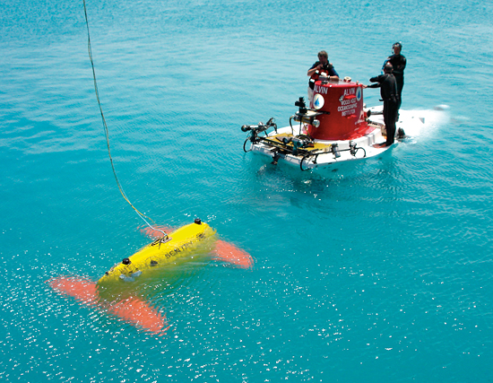
The new WHOI Sentry autonomous underwater vehicle meets the submersible Alvin during a testing expedition off Bermuda in April 2006. 

Sentry is a robotic underwater vehicle used for exploring the deep ocean; it will often be used to complement Alvin by surveying large swaths of ocean floor to determine the best spots for close-up exploration. 

Sentry is part of the National Deep Submergence Facility

Photo by Chris German, Woods Hole Oceanographic Institution