
The eruption, which is still in progress, appears to be of no danger at this time to the surrounding population and the city of Goma, or the mountain gorillas and other wildlife.
Picture: LuAnne Cadd / Barcroft Media


 Tantalum from coltan is used to manufacture electronic capacitors, used in consumer electronics products such as cell phones, DVD players, video game systems and computers.
  Saving Gorillas Starts With Understanding Their Human Neighbours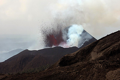
Following the eruption, scientists and local authorities have been using a long series of space images from ESA’s Envisat, together with seismic and helicopter data, to monitor the situation and calm fears of the local population.
Dr Nicolas d’Oreye of GORISK, which is in Congo assisting the Goma Volcano Observatory to collect and process satellite observations and field data, said the satellite images are very useful for managing the crisis.
"As well as helping to validate information from different datasets, the satellite images are providing invaluable information about the situation, such as the details about the lava flow and the fact that the Nyiragongo volcano is not showing any signs of abnormal activity.
 | 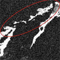 |
Path of lava flow |
Goma, the capital of the North Kivu province, is situated along the southern margin of the lava fields from these volcanoes. Lava from the Nyamulagira (height 3058 m) eruption has been flowing in a direction south and southwest of the volcano, raising concerns that lava could cover the Goma and Sake road within weeks, causing widespread chaos and threatening the local economy.
"Lava flows from Nyamulagira are usually not a direct threat for the population and the infrastructure except when it develops southwards, as it is in this case," explained Dr d’Oreye, a senior scientist at the Geophysics/Astrophysics Department of the National Museum of Natural History in Luxembourg. "In this situation, it is crucial to monitor the flow size, direction and speed for the authorities to be able to make timely decisions."
Lava flows can be mapped by comparing satellite radar images acquired before and after the eruption. In the images, old lava appears bright white. If an area appears white in before images and black in after images, then the ground has changed between acquisitions by the flow of new lava.

 Posts
All Comments
Posts
All Comments


