Showing posts with label operational. Show all posts

Monday, October 6, 2014

ESA Sentinel-1: First Copernicus satellite now operational - Video

Napa Valley quake. 

Credit: Copernicus data (2014) /ESA /PPO.labs /Norut /COMET-SEOM Insarap study

With the commissioning of ESA's Sentinel-1A completed and the satellite's transfer to the team in charge of its exploitation, its data are available as of today to all users.

This marks the beginning of the satellite's operational life, delivering radar coverage for an array of applications in the areas of oceans, ice, changing land and emergency response.

Project Manager Ramón Torres, who led the development team, formally handed over the satellite to the Mission Manager, Pierre Potin.

"The time has arrived for the satellite to exploit its extraordinary capabilities and start helping users," said Ramón.

A leap forward from ESA's earlier Envisat, the unprecedented quality of ESA's Sentinel-1A will ensure that all users' needs are fully met.

"Of course, saying farewell is always difficult, but I am confident that it is in capable and safe hands for the next stage of its journey."

Launched on 3 April, ESA's Sentinel-1A completed commissioning on 23 September, an important process that ensures the satellite, instruments, data acquisition and data processing procedures are working well.

Not only did ESA's Sentinel-1A pass these tests and reach its target orbit on 7 August, eight anticollision manoeuvres to avoid space debris were performed during this phase.


ESA's Sentinel-1A is the first satellite dedicated to Europe’s Copernicus environmental monitoring programme. 

This new satellite carries an advanced synthetic aperture radar that works in several specialised modes to provide detailed imagery for monitoring the oceans, including shipping lanes, sea ice and oil spills. 

It also provides data to map changing land cover, ground deformation, ice shelves and glaciers, and can be used to help emergency response when disasters such as floods strike and to support humanitarian relief efforts at times of crisis. 

Credit: ESA/ATG medialab

The satellite will now begin delivering radar scans for an array of operational services and scientific research.

"My main objective is to ensure that ESA's Sentinel-1A fulfils the high expectations from the various operational services and scientific users," notes Pierre.

"Looking at the satellite and ground segment performance, as demonstrated during the commissioning, as well as the preliminary results achieved so far, I'm confident that the mission will be a great success."

The satellite will continue to be monitored, operated and controlled from ESA's Space Operations Centre in Darmstadt, Germany.


The Sentinels are a new fleet of ESA satellite poised to deliver the wealth of data and imagery that are central to Europe's Copernicus programme.

By offering a set of key information services for a broad range of applications, this global monitoring programme is a step change in the way we manage our environment, understand and tackle the effects of climate change, and safeguard everyday lives.

ESA's Sentinel-1A, a two-satellite constellation, is the first in the series and carries an advanced radar to provide an all-weather, day-and-night supply of imagery of Earth's surface.

Wednesday, September 29, 2010

ESA's GOCE Operational again


Following recovery from a glitch that prevented ESA’s GOCE gravity mission from sending any scientific data to the ground, the satellite has been gently brought back down to its operational altitude and resumed normal service – delivering the most detailed gravity data to date.

Data from GOCE will result in a unique model of the ‘geoid’, which is the surface of an ideal global ocean at rest. It is a crucial reference for accurately measuring ocean circulation, sea-level change and ice dynamics – all affected by climate change. Volker Liebig,

Director of ESA’s Earth Observation Programmes, said," I am very happy that the scientific measurements now continue and we can profit from the current low solar activity and measure the best-ever geoid." 

To observe the strongest gravity signal possible, the Gravity field and steady-state Ocean Explorer (GOCE) orbits at an exceptionally low altitude: just 255 km above Earth, skimming the fringes of our atmosphere. However, when the telemetry problem was discovered in July, operators raised GOCE’s orbit to 263 km while experts set about fixing it.

The reason for this was to safeguard the sophisticated xenon ion engines, which gently compensate for atmospheric drag in the satellite’s normal low orbit. The thrusters help to keep the satellite stable in ‘free fall’ to prevent any buffeting from the residual air at this low altitude, which could drown out the gravity data.

The telemetry problem was resolved earlier this month and operators have spent the last three weeks gently bringing GOCE back down to the very precise altitude of 254.9 km – within 10 m!

The first global gravity model based on GOCE satellite data was presented at ESA’s Living Planet Symposium.

Based on only two months of data, from November and December 2009, it illustrates the excellent capability of GOCE to map tiny variations in Earth’s gravity field.

Credits: ESA – GOCE High Level Processing Facility

Now back in the correct orbit with all systems fully functional, GOCE is back to its job of mapping Earth’s gravity with unprecedented accuracy and resolution.

ESA’s GOCE Mission Manager, Rune Floberghagen said, "After working hard to resolve the problem we experienced with the telemetry transmission, it certainly feels good to have the satellite back doing its job of measuring of the gravity field."

Tuesday, September 28, 2010

NASA NPOESS: National Polar-orbiting Operational Environmental Satellite System


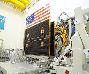
Ball Aerospace technicians perform a pop-and-catch partial deploy of the NASA National Polar-orbiting Operational Environmental Satellite System (NPOESS) Preparatory Project (NPP) weather satellite's solar array during this week's successful pre-environmental review in advance of flight environmental testing.

This is one of the final satellite activities being done prior to the Vibration testing, the first phase of environmental tests. Credit: Ball Aerospace.

A group of multi-disciplinary experts from NASA and NOAA, as well as a number of independent reviewers conducted the pre-environmental review of the five-instrument satellite.

The review team assessed the satellite test activities completed to-date, the completeness and adequacy of the environmental test plans, and determined the satellite is ready to proceed with its environmental test campaign.

"We are confident that the NPP satellite systems are robust and we are preparing the satellite to undergo rigorous environmental testing," stated Ken Schwer, NPP Project Manager, at NASA's Goddard Space Flight Centre. The launch is slated for October 2011.

The five-instrument suite includes: the Visible/Infrared Imager Radiometer Suite (VIIRS); the Cross-track Infrared Sounder (CrIS); the Clouds and the Earth Radiant Energy System (CERES); the Advanced Technology Microwave Sounder (ATMS); and the Ozone Mapping and Profiler Suite (OMPS).

NPP's advanced visible, infrared, and microwave imagers and sounders will improve the accuracy of climate observations and enhance capabilities to the nation's civil and military users of satellite data.

NPP is designed to provide continuity with NASA's Earth Observing System (EOS) satellites for climate observations and to provide the operational weather community with risk reduction for the next generation of weather satellites.

Monday, March 22, 2010

NASA & NOAA: Weather Satellite GOES-15 operational


Boeing Satellite and Intelligence Systems operations will transition the routine health and safety monitoring to the NASA Goddard operations team on March 24.

Twelve days after a flawless launch, NASA and NOAA's Geostationary Operational Environmental Satellite-P (GOES-P) reached its proper orbit and was renamed GOES-15.

The latest weather satellite will complete its checkout in mid August 2010 and be stored in-orbit, ready for activation should one of the operational GOES satellites degrade or exhaust their fuel.

"The NASA team has done an excellent job and the spacecraft performance has been near perfect. Reaching the proper orbit marks a significant milestone, but we still have a lot of work to complete," stated Andre Dress, the NASA GOES Deputy Project Manager. "We remain focused on the tasks at hand and look forward to complete mission success."

Since GOES-P launched on-board a United Launch Alliance Delta IV rocket on March 4, the satellite has undergone 5 orbit raising maneuvers before arriving at its checkout longitude of 90 degrees West, where it orbits at approximately 22 thousand miles above the Earth's surface.

NASA Engineers and controllers deployed the Solar Array on March 17 and they will turn on the Imager and Sounder on March 23. The Imager is expected to capture the first visible image on April 5.

GOES-15 is the third and final spacecraft to be launched in the GOES N-P Series of geostationary environmental weather satellites. With two operational satellites, they provide weather observations that cover over 50 percent of the Earth's surface.

Boeing Satellite and Intelligence Systems operations will transition the routine health and safety monitoring to the NASA Goddard operations team on March 24.

At this time the NASA and NOAA team will commence with the post launch verification testing, which will last for approximately 150 days. Once all the systems are checked out, the satellite will be turned over to NOAA for operational control.