Showing posts with label Landsat. Show all posts

Thursday, May 16, 2013

Google: New Public Application of Landsat Images Released

The Columbia Glacier.

Credit: Nasa Earth Observatory

Google released more than a quarter-century of images of Earth taken from space Thursday compiled into an interactive time-lapse experience. 

Working with data from the Landsat Program managed by the U.S. Geological Survey, the images display an historical perspective on changes to Earth's surface over time.

NASA Associate Administrator for Communications David Weaver issued the following statement about the Google announcement:

"The Landsat data record -- humanity's longest continuous record of our planet from space -- has been an invaluable tool for scientists and decision-makers in many fields, from natural resources to agricultural productivity and climate change.

The release on Google's Earth Engine of new Landsat time-lapse data animations shows key changes across our planet and helps share this remarkable U.S. resource with the public in an engaging new way.

"The Obama administration is committed to keeping this freely accessible archive of continuous global land observations growing for years to come. That's why the president's Fiscal Year 2014 budget includes funding to have NASA take the lead on the design of a new spaceborne system that will continue the acquisition of Landsat-quality measurements.

"NASA launched the newest Landsat satellite in February. Later this month, we will be handing over operations of this mission to our long-time partners at the U.S. Geological Survey. NASA is looking forward to beginning the work to extending this critically important national resource."

Monday, May 6, 2013

NASA USGS Landsat thermal sensor lights up from volcano's heat

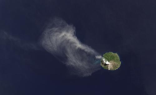
An ash plume drifts from Paluweh volcano in Indonesia in this image, taken April 29, 2013, from the Landsat Data Continuity Mission's Operational Land Imager instrument

Credit: Robert Simmon, NASA's Earth Observatory, using data from USGS and NASA

As the Landsat Data Continuity Mission satellite flew over Indonesia's Flores Sea April 29, it captured an image of Paluweh volcano spewing ash into the air.

The satellite's Operational Land Imager detected the white cloud of smoke and ash drifting northwest, over the green forests of the island and the blue waters of the tropical sea.

The Thermal Infrared Sensor (TIRS) on LDCM picked up even more.

By imaging the heat emanating from the 5-mile-wide volcanic island, TIRS revealed a hot spot at the top of the volcano where lava has been oozing in recent months.

The two LDCM instruments, working together, illustrate a quote from Aristotle: The whole is greater than the sum of its parts, said Betsy Forsbacka, TIRS instrument manager at NASA's Goddard Space Flight Center in Greenbelt, Md.

"Each instrument by itself is magnificent," she said. "When you put them together, with the clues that each give you on what you're seeing on Earth's surface, it's greater than either could do by themselves."

The image of Paluweh also illuminates TIRS' abilities to capture the boundaries between the hot volcanic activity and the cooler volcanic ash without the signal from the hot spot bleeding over into pixels imaging the cooler surrounding areas.

TIRS engineers tested and refined the instrument pre-launch to ensure each pixel correctly represents the heat source it images on Earth's surface.

Otherwise, Forsbacka said, it would be like shining a flashlight in your eyes—the bright light can leave you seeing spots and halos where it should be dark.

The same effect can occur with detectors. But the contrast is sharp on the Paluweh image.

A bright white hot spot, surrounded by cooler dark ash clouds, shows the volcanic activity at Paluweh volcano in the Flores Sea, Indonesia. 

This thermal image was taken by the Landsat Data Continuity Mission's Thermal Infrared Sensor on April 29, 2013. 

Credit: Robert Simmon, NASA's Earth Observatory, using data from USGS and NASA

"We can image the white, representing the very hot lava, and right next to it we image the gray and black from the cooler surrounding ash," Forsbacka said.

"It's exciting that we're imaging such diverse thermal activity so well. The TIRS instrument can also pick up subtle shifts of temperatures, within a 10th of a degree Celsius and, with two different thermal bands instead of the one band on previous Landsat satellites, LDCM is poised to make it easier for scientists to subtract out the effects of the atmosphere on the signal, obtaining a more accurate temperature of Earth's surface."

Friday, March 22, 2013

NASA, USGS release first Landsat 8 images

The area around Boulder, Colo., is shown here in a true colour image collected by the OLI aboard LDCM on March 18, 2013. 

The OLI and an important component of TIRS, its cryocooler, were built at the Ball Aerospace & Technologies Corporation facility in Boulder. 

Credit: USGS/NASA Earth Observatory

NASA and the Department of the Interior's U.S. Geological Survey (USGS) have released the first images from the Landsat Data Continuity Mission (LDCM) satellite, which was launched Feb. 11.

The natural-colour images show the intersection of the United States Great Plains and the Front Range of the Rocky Mountains in Wyoming and Colorado.

In the images, green coniferous forests in the mountains stretch down to the brown plains with Denver and other cities strung south to north.

"We are very excited about this first collection of simultaneous imagery," said Jim Irons, LDCM project scientist at NASA's Goddard Space Flight Center in Greenbelt, Md.

"These images confirm we have two healthy, functioning sensors that survived the rigors of launch and insertion into Earth orbit."

Since launch, LDCM has been going through on-orbit testing.

The mission operations team has completed its review of all major spacecraft and instrument subsystems, and performed multiple spacecraft attitude maneuvers to verify the ability to accurately point the instruments.

The two LDCM sensors collect data simultaneously over the same ground path. OLI collects light reflected off the surface of Earth in nine different regions of the electromagnetic spectrum, including bands of visible light and near-infrared and short-wave-infrared bands, which are beyond human vision.

TIRS collects data at two longer wavelength thermal infrared bands that measure heat emitted from the surface.

By looking at different band combinations, scientists can distinguish features on the land surface.

These features include forests and how they respond to natural and human-caused disturbances, and the health of agricultural crops and how much water they use.

Data from LDCM will extend a continuous, 40-year-long data record of Earth's surface from previous Landsat satellites, an unmatched, impartial perspective that allows scientists to study how landscapes all across the world change through time.

The natural-colour images were processed by the EROS Data Center north of Sioux Falls.

"These first scenes from the new Landsat satellite continue the remarkable output from the Landsat program with better, more useful imagery and information," said Matthew C. Larsen, associate director for climate and land use change at the U.S. Geological Survey in Reston, Va.

"We are gratified that this productive partnership between USGS and NASA has maintained the continuity and utility of this essential satellite tool, providing the foundation for land and water management around the globe."

As planned, LDCM currently is flying in an orbit slightly lower than its operational orbit of 438 miles (705 kilometers) above Earth's surface.

As the spacecraft's thrusters raise its orbit, the NASA-USGS team will take the opportunity to collect imagery while LDCM is flying under Landsat 7, also operating in orbit.

Measurements collected simultaneously from both satellites will allow the team to cross-calibrate the LDCM sensors with Landsat 7's Enhanced Thematic Mapper-Plus instrument.

"So far, our checkout activities have gone extremely well," said Ken Schwer, LDCM project manager at Goddard.

"The mission operations team has done a tremendous job getting us to the point of imaging Earth." During the next few weeks, this team will calibrate the instruments and verify they meet performance specifications.

After its checkout and commissioning phase is complete, LDCM will begin its normal operations in May. At that time, NASA will hand over control of the satellite to the USGS, which will operate it throughout its planned five-year mission life.

The satellite will be renamed Landsat 8. USGS will process data from OLI and TIRS and add it to the Landsat Data Archive at the USGS Earth Resources Observation and Science Center, where it will be distributed for free via the Internet.

For more information on these first LDCM images

For more information on the LDCM mission.

Monday, February 11, 2013

NASA Launching Powerful Landsat Earth-Observation Satellite

The payload faring containing the Landsat Data Continuity Mission LDCM spacecraft is lifted to the top of Space Launch Complex-3E at Vandenberg Air Force Base where it will be hoisted atop a United Launch Alliance Atlas V for launch. 

CREDIT: NASA/VAFB

NASA's latest Earth-observation satellite blasted off Feb. 11, continuing a venerable program that has been monitoring environmental change and resource use for more than four decades.

The Landsat Data Continuity Mission launched atop an Atlas 5 rocket from Vandenberg Air Force Base in California.

The LDCM spacecraft will track changes in forest cover, agricultural output and urban sprawl, among other things, adding to a Earth-observation record that has been growing continuously since Landsat 1 lifted off in July 1972.

"LDCM will be the best Landsat spacecraft yet, in terms of improved capabilities and the amount of data returned," mission program executive David Jarrett, of NASA headquarters in Washington, D.C., told reporters Friday (Feb. 8) in a prelaunch press briefing. "LDCM will continue the Landsat legacy well into the future."

The new satellite separated from the rocket an hour and twenty minutes after liftoff, and the peep of its first signal was received three minutes later at a ground station in Norway.

The satellite will reach its operational orbit 438 miles (735 kilometers) over the Earth within two months.

It is designed to have a minimum five year life span, although it is fueled for a 10-year run in space, orbiting the Earth about 14 times a day.

The satellite is the eighth in a series that has been instrumental in tracking the changing face of the planet.

"This data is a key tool for monitoring climate change and has led to the improvement of human and biodiversity health, energy and water management, urban planning, disaster recovery and agriculture monitoring -- all resulting in incalculable benefits to the U.S. and world economy," NASA administrator Charles Bolden said in a statement.

The new spacecraft's powerful sensors will gather 400 "screens" of the planet a day and relay them for storage in ground base archives where they can be accessed by anyone.

Landsat Data Continuity Mission and ULA Atlas-V Launcher: Pre-launch Checks

The United Launch Alliance (ULA) Atlas V rocket with the Landsat Data Continuity Mission (LDCM) spacecraft onboard is seen on Sunday, Feb. 10, 2013 at Vandenberg Air Force Base, Calif.

The Landsat Data Continuity Mission (LDCM) mission is a collaboration between NASA and the U.S. Geological Survey that will continue the Landsat program's 40-year data record of monitoring the Earth's landscapes from space. 

The spacecraft is scheduled to launch Feb. 11.

Photo Credit: NASA/Bill Ingalls

Wednesday, December 26, 2012

Eighth Landsat LDCM Satellite Arrives At Launch Site

An oversized semi-trailer truck carrying NASA's Landsat Data Continuity Mission (LDCM) has arrived at its launch site at Vandenberg Air Force Base in California in preparation for launch. 

This NASA and U.S. Geological Survey mission will continue a 40-year record of measuring change on the planet from space.

LDCM is the eighth satellite in the Landsat series, which began in 1972. It will extend and expand global land observations that are critical in many sectors, including energy and water management, forest monitoring, human and environmental health, urban planning, disaster recovery and agriculture.

Following final tests, the LDCM satellite will be attached to an Atlas V rocket and launched into space Feb. 11, 2013. Built and tested by Orbital Sciences Corp., LDCM left their Gilbert, Ariz., facility on Dec. 17.

"LDCM builds on and strengthens a key American resource: a decades-long, unbroken Landsat-gathered record of our planet's natural resources, particularly its food, water and forests," said Jim Irons, Landsat project scientist at NASA's Goddard Space Flight Center in Greenbelt, Md.

LDCM carries two instruments, the Operational Land Imager (OLI) built by Ball Aerospace and Technologies Corp. in Boulder, Colo., and the Thermal Infrared Sensor (TIRS) built by NASA Goddard.

"Both of these instruments have evolutionary advances that make them the most advanced Landsat instruments to date and are designed to improve performance and reliability to improve observations of the global land surface," said Ken Schwer, LDCM project manager at NASA Goddard.

OLI will continue observations in the visible, near infrared, and shortwave infrared portions of the electromagnetic spectrum and includes two new spectral bands, one of which is designed to support monitoring of coastal waters and the other to detect previously hard to see cirrus clouds that can otherwise unknowingly impact the signal from the Earth's surface in the other spectral bands.

TIRS will collect data in two thermal bands and will thus be able to measure the temperature of the Earth's surface, a measurement that's vital to monitoring water consumption, especially in the arid western United States.

Friday, July 27, 2012

NASA LandSat: Catastrophic growth of China’s megacities and Pollution levels

In 1973, NASA and United States Geological Survey’s Landsat 3 satellite took the image above of quiet, rural land (plant-covered land is red) along China’s Pearl River Delta. 

Six years later, in 1979, the region began to grow as China set up two economic zones north of Hong Kong. 

Then, 30 years later, in 2003, Landsat 7 satellite took this dramatic shot:


Images: NASA/USGS

It’s a catastrophic urban shift, happening all over China, with an unsupportable increase in demand for natural resources and the associated suchoking rge in pollution levels.

You can see the booming urban areas in gray, a major contrast to the mostly red image from 1973.

In the image you can see part of Guangzhou, the most populous urban area in the region today with 12,700,000 people; Dongguan, an urban area with more than 8 million people; and Foshan with more than 7 million. As of 2010, the Pearl District Economic Zone had a population of 36 million.

You can see more before and after images from 10 other cities across the globe. Or, at The Atlantic Cities, check out Nate Berg’s slightly jarring animated GIF rendition of the urban shift.

Thursday, July 26, 2012

NASA Landsat Images: The Longest Continuous View of Earth From Space

NASA and the Interior Department Monday marked the 40th anniversary of the Landsat program, the world’s longest-running Earth-observing satellite program. 

The first Landsat satellite was launched July 23, 1972, from Vandenberg Air Force Base in California.

The 40-year Landsat record provides global coverage that shows large-scale human activities such as building cities and farming.

The program is a sustained effort by the United States to provide direct societal benefits across a wide range of human endeavors, including human and environmental health, energy and water management, urban planning, disaster recovery and agriculture.

Landsat images from space are not merely pictures. They contain many layers of data collected at different points along the visible and invisible light spectrum. A single Landsat scene taken from 400 miles above Earth can accurately detail the condition of hundreds of thousands of acres of grassland, agricultural crops or forests.

“Landsat has given us a critical perspective on our planet over the long term and will continue to help us understand the big picture of Earth and its changes from space,” said NASA Administrator Charles Bolden. “With this view we are better prepared to take action on the ground and be better stewards of our home.”

In cooperation with the U.S. Geological Survey (USGS), a science agency of the Interior Department, NASA launched six of the seven Landsat satellites. The resulting archive of Earth observations forms a comprehensive record of human and natural land changes.

“Over four decades, data from the Landsat series of satellites have become a vital reference worldwide for advancing our understanding of the science of the land,” said Interior Department Secretary Ken Salazar.

“The 40-year Landsat archive forms an indelible and objective register of America’s natural heritage and thus it has become part of this department’s legacy to the American people.”

Remote-sensing satellites such as the Landsat series help scientists to observe the world beyond the power of human sight, to monitor changes and to detect critical trends in the conditions of natural resources.

“With its entirely objective, long term records for the entire surface of the globe, the Landsat archive serves as the world’s free press, allowing any person, anywhere, to access vital information without charge,” said Interior’s Anne Castle, assistant secretary for water and science. “Landsat has been a game changer for agricultural monitoring, climate change research and water management.”

NASA is preparing to launch the next Landsat satellite, the Landsat Data Continuity Mission (LDCM), in February 2013 from Vandeberg. LDCM will be the most technologically advanced satellite in the Landsat series.

LDCM sensors take advantage of evolutionary advances in detector and sensor technologies to improve performance and increase reliability. LDCM will join Landsat 5 and Landsat 7 satellites in Earth orbit to continue the Landsat data record.

“The first 40 years of the Landsat program have delivered the most consistent and reliable record of Earth’s changing landscape,” said Michael Freilich, director of NASA’s Earth Science Division in the Science Mission Directorate in Washington.

“We look forward to continuing this tradition of excellence with the even greater capacity and enhanced technologies of LDCM.”

NASA and USGS will highlight the accomplishments of the Landsat program in a televised news briefing 11 a.m. EDT, Monday at the Newseum, 555 Pennsylvania Ave. NW, in Washington.

During the briefing, the agencies will announce the 10 most significant images from the Landsat record; the U.S. regions selected for the “My American Landscape” contest showing local environmental changes; and the top five Landsat “Earth As Art” images selected in an online poll.

The public is encouraged to participate in the briefing’s question-and-answer sessions by using the Twitter hashtag #asknasa.

NASA Television and the NASA website will provide live briefing coverage. For NASA TV streaming video, scheduling and downlink information, visit: http://www.nasa.gov/ntv

For more information about the Landsat program, visit: http://landsat.usgs.gov and http://www.nasa.gov/landsat

Tuesday, July 24, 2012

LANDSAT Looks over Megalopolis - Video

In 1972, NASA's Landsat program launched on a mission to planet Earth. Sensing at several wavelengths, the satellite brought Dartmouth University researchers vital data on urban growth the in East Coastal U.S.. Credit: NASA

Sunday, April 1, 2012

NASA LandSat Images: The Syrian Desert appears Greener

In this series of four Landsat images, the agricultural fields are about one kilometer across. 

Healthy vegetation appears bright green while dry vegetation appears orange. 

Barren soil is a dark pink, and urban areas, like the town of Tubarjal at the top of each image, have a purple hue. Credit: NASA/GSFC.

Saudi Arabia is drilling for a resource possibly more precious than oil.

Over the last 24 years, it has tapped hidden reserves of water to grow wheat and other crops in the Syrian Desert. This time series of data shows images acquired by three different Landsat satellites operated by NASA and the U.S. Geological Survey.

The green fields that dot the desert draw on water that in part was trapped during the last Ice Age. In addition to rainwater that fell over several hundred thousand years, this fossil water filled aquifers that are now buried deep under the desert's shifting sands.

Saudi Arabia reaches these underground rivers and lakes by drilling through the desert floor, directly irrigating the fields with a circular sprinkler system. This technique is called center-pivot irrigation.

Because rainfall in this area is now only a few centimeters (about one inch) each year, water here is a non-renewable resource. Although no one knows how much water is beneath the desert, hydrologists estimate it will only be economical to pump water for about 50 years.

In this series of four Landsat images, the agricultural fields are about one kilometer (.62 miles) across.

The images were created using reflected light from the short wave-infrared, near-infrared, and green portions of the electromagnetic spectrum (bands 7, 4, and 2 from Landsat 4 and 5 TM and Landsat 7 ETM+ sensors). Using this combination of wavelengths, healthy vegetation appears bright green while dry vegetation appears orange.

Barren soil is a dark pink, and urban areas, like the town of Tubarjal at the top of each image, have a purple hue.

Landsat 4 launched in 1982 and provided scientific data for 11 years until 1993. NASA launched Landsat 5 in 1984 and it ran a record-breaking 28 years, sending back what was likely its last data in 2011. Landsat 7 is still up and running; it was launched in 1999.

The data from these and other Landsat satellites has been instrumental in increasing our understanding of forest health, storm damage, agricultural trends, urban growth, and many other ongoing changes to our land.

NASA and the U.S. Department of the Interior through the U.S. Geological Survey (USGS) jointly manage Landsat, and the USGS preserves a 40-year archive of Landsat images that is freely available data over the Internet.

The next Landsat satellite, now known as the Landsat Data Continuity Mission (LDCM) and later to be called Landsat 8, is scheduled for launch in January 2013.

Friday, November 4, 2011

ESA LandSat Image: Australian lakes

This Landsat satellite image shows a portion of Lake Eyre (lower-left corner) and the north-south sand dunes of the Simpson and Tirari deserts in the remote outback of South Australia.

The Thematic Mapper on Landsat 5 acquired this image on 31 May 2011. ESA supports the Landsat series as a Third Party Mission, meaning it uses its ground infrastructure and expertise to acquire, process and distribute Landsat data to users.

Credits: USGS

Saturday, September 3, 2011

NASA Landsat Program - Etosha Pan, Namibia

In north Namibia, the Etosha pan—a 75-mile long dry lakebed—makes up part of the Namib Desert.

The Etosha salt pan is mostly made up of dry mud and salt.

The Ekuma River is the salt pan’s sole source of water.

In this image the Etosha pan is blue, violet, cyan and white.

Vegetation is green and bare ground appears brown, pink and red. Clouds are white.

This Landsat 7 image was acquired April 22, 2000.

It is a false colour image using ETM+ bands 7,4, and 2.

The Etosha pan falls on Landsat WRS-2 Path 179 Row 73.

References
Wikipedia. Etosha pan.
More feature images.

NASA Landsat Program - Chesapeake Bay

USGS has released a new mosaic of the Chesapeake Bay.

Using six Landsat 5 images collected in July 2009 and 2011 a beautiful, seamless mosaic of the Chesapeake Bay region was created by the USGS Landsat team.

The Washington D.C.-Baltimore-Philadelphia-New York City corridor can be clearly seen (look for silvery purple) as can the Chesapeake and Delaware Bays and the coastal Atlantic barrier islands from Fishermans Island, Virginia to Sandy Hook, New Jersey.

Thursday, November 25, 2010

NASA Landsat-7 Image: Great Barrier Reef

What might be mistaken for dinosaur bones being unearthed at a paleontological dig are some of the individual reefs that make up the Great Barrier Reef, the world's largest tropical coral reef system.

The reef stretches more than 2,000 kilometers (1,240 miles) along the coast of Queensland, Australia.

It supports astoundingly complex and diverse communities of marine life and is the largest structure on the planet built by living organisms.

Credit: USGS/NASA/Landsat 7

To learn more about the Landsat satellite go to: landsat.gsfc.nasa.gov/

NASA Landsat-7 Image: Saudi Arabia and Yemen

Description: White pinpricks of cloud cast ebony shadows on the Rub' al Khali, or Empty Quarter, near the border between Saudi Arabia and Yemen.

The lines of wind-sculpted sand are characteristic of immense sand deserts, or sand seas, and the Rub' al Khali is the largest desert of this type in the world.

A highland ridge is just high enough to disturb the flow of the lines. In the center of that interruption lies the Saudi Arabian town of Sharurah.

Credit: USGS/NASA/Landsat 7

To learn more about the Landsat satellite go to: landsat.gsfc.nasa.gov/

NASA Landsat-7 Image: Mighty Mississippi

Description: Small, blocky shapes of towns, fields, and pastures surround the graceful swirls and whorls of the Mississippi River.

Countless oxbow lakes and cutoffs accompany the meandering river south of Memphis, Tennessee, on the border between Arkansas and Mississippi, USA.

The "mighty Mississippi" is the largest river system in North America.

Credit: USGS/NASA/Landsat 7

To learn more about the Landsat satellite go to: landsat.gsfc.nasa.gov/

NASA Landsat-5 Image: Siberia, Chaunskaya Bay

Vivid colors and bizarre shapes come together in an image that could be an imaginative illustration for a fantasy story.

This labyrinth of exotic features is present along the edge of Russia's Chaunskaya Bay (vivid blue half circle) in northeastern Siberia.

Two major rivers, the Chaun and Palyavaam, flow into the bay, which in turn opens into the Arctic Ocean. Ribbon lakes and bogs are present throughout the area, created by depressions left by receding glaciers.

Credit: USGS/NASA/Landsat 5

To learn more about the Landsat satellite go to: landsat.gsfc.nasa.gov/

Wednesday, November 24, 2010

NASA Thematic Mapper on Landsat-5: Sivash Lagoons

A picture released by the Nasa Earth Observatory shows a natural-colour image captured by the Thematic Mapper on NASA's Landsat 5 satellite.

The shallow waters of a network of lagoons known as Sivash appear in shades of peach, mustard, lime green, brilliant blue, muted blue-green, beige, and brown.

From mainland Ukraine, the Crimean Peninsula extends southward into the Black Sea. The peninsula is bordered on the west by the Black Sea, and on the east by the Sea of Azov.

Stretching across the peninsula is a network of shallow, marshy inlets sprawling over roughly 1,000 square miles (2,600 square kilometres).

During the summer months, warmed marsh waters give off unpleasant odours, lending the region nicknames of Rotten Sea or Putrid Sea.

Picture: AFP/NASA

Saturday, June 5, 2010

60 Stunning Landsat Satellite Photos of Earth

60 Stunning Landsat Satellite Photos of Earth


Looking at nature from different perspectives can create stunning compositions for your photographs.

This couldn’t be more true than when we look at our planet from outer space and appreciate the reality of its beauty from such an incredible and rarely seen perspective.

The images in this compilation are from the Landsat 7 satellite and were created to introduce the general public to the Landsat Program.

Various combinations of the eight Landsat 7 spectral bands were selected to create the vivid RGB composites that we have featured.

Here are 60 absolutely stunning images of the Earth as seen from outer space. Click on the images for large resolution versions which you can use as wallpapers.