Showing posts with label high-speed data. Show all posts

Wednesday, April 4, 2012

NASA Kepler Explorer App Puts Distant Planets at Fingertips

Armchair explorers of the cosmos can now have at their fingertips the nearly 2,000 distant planetary systems discovered by NASA's Kepler Mission. Kepler Explorer, an innovative app for iPads and iPhones developed by a team at the University of California, Santa Cruz, provides interactive displays of newly discovered planetary systems based on Kepler data.

Now available for free from the iTunes App Store, Kepler Explorer was developed through the OpenLab initiative at UC Santa Cruz, which brought together faculty and students in astrophysics, art, and technology for a summer institute last year.

The Kepler Explorer team includes astrophysicist Jonathan Fortney, a member of the Kepler science team; two of his graduate students, Eric Lopez and Caroline Morley; artist Kyle McKinley, a recent graduate of the Digital Arts and New Media program; and John Peters, a recent graduate of the computer game design program.

"I learned a lot about astrophysics from this project. It was a lot of fun," said Peters, who wrote all of the software code for the app.

Fortney, an associate professor of astronomy and astrophysics at UCSC, said he enjoyed the opportunity to work on a project that could reach a wider audience than most of his research.

The team quickly settled on the idea to create an app, and also developed it into an exhibit that provides additional information and shows the app's output on a large screen.

The exhibit was part of two OpenLab public exhibitions last year, one at the UCSC Digital Arts Research Center and another at the Tech Museum in San Jose.

It is scheduled for long-term installation in the Lick Observatory visitors gallery later this month.

Kepler Explorer starts with drop-down menus listing all the Kepler-discovered planetary systems, plus our own solar system.

The selected system is displayed in a view that shows the planet or planets in their orbits around the host star.

Shown in real time the planets look motionless, but moving a slider increases the speed until the planets zip around their star.

The touch screen lets users zoom in and move around the system, and tapping on an individual planet brings it up for further exploration.

Another view shows the relative sizes of the individual planets compared to their host star.

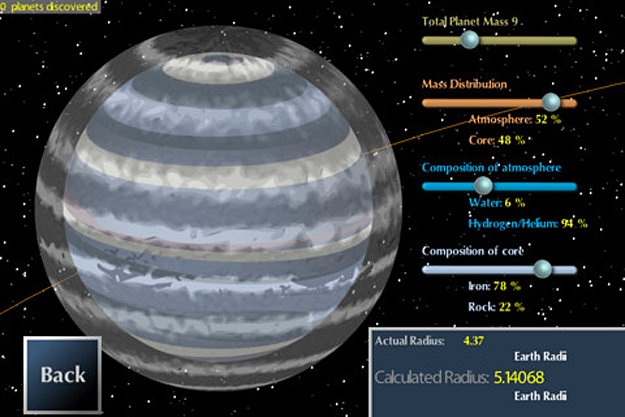
Kepler Explorer's most innovative features are seen when viewing individual planets. The user can manipulate the composition of the planet and its atmosphere and see which mixtures of components (iron, rock, water, and hydrogen) are consistent with Kepler's observations.

This feature represents graphically the type of in-depth analysis that Fortney does for the Kepler Mission. "I have pretty good intuition for what the likely composition of a planet is based on its size, but the app allows anyone to explore the properties of many different planets very quickly," he said.

Because Kepler detects planets as they pass in front of their host star, it only measures the radius of a planet, or how big it is. In most cases, the mass of the planet is unknown.

When the mass is unconstrained, there may be different combinations of components that result in a planet of a given size.

The app's interactive graphics show how this works. There are sliders for different components and how they are partitioned in the core and the atmosphere, and as you move the sliders the image of the planet grows and shrinks, based on hundreds of calculations.

As you change the settings, the app tells you when the size of your planet matches the observations. The calculations involved took hours of computer time, but the results are stored in tables so the app can use them on the fly.

"For a large-radius planet, you can very quickly tell that it can't be a rocky planet, for example, and that in itself is pretty informative," Lopez said.

So far, the Kepler Mission has detected a total of 2,321 planet candidates orbiting 1,790 host stars. Automatic updates for the Kepler Explorer app will add new planet candidates as they are discovered.

Jennifer Parker, an associate professor of art, started the OpenLab initiative in 2011 with astrophysicist Enrico Ramirez-Ruiz, who invited Fortney to participate, and recent graduates Amy Boewer and Jack O'Neill.

"We wanted to bring together faculty who are interested in interdisciplinary work with students from a range of disciplines," Parker said.

"There is such a vast amount of research on this campus, and one way to share it with the public is to make tangible things and playable media. It's not just about art illustrating science.

OpenLab is creating a space for new ways of thinking that can emerge from conversations between different disciplines."

Thursday, February 23, 2012

Scotland Space Scientific Research and Innovation is reaching for the stars

At last Scotland is being seen as playing a leading role in the space sector after decades of being the engineers, scientists and innovators that break down technological barriers in other countries' space programs.

The space sector contributes £5.6 billion to the UK economy, as well as supporting 68,000 high-value jobs. Not only that, it has soared above the recent economic headwinds, growing an average of 9 per cent each year since 1999.

Scotland-based companies are playing a key role in that success story. Clyde Space is leading the design and manufacture of the UKube-1 satellite – the UK’s first satellite commissioned by the UK Space Agency.

Other examples include Star-Dundee, which sells its data-handling test products to almost every international space agency, while Selex Galileo, in Edinburgh, is tapping into the market for European satellites.

Commercial success also goes hand in hand with globally recognised academic excellence, with the recent launch of the Space Glasgow research cluster by the UK Science Minister David Willetts.

Scotland is also involved with key instruments for the James Webb Space Telescope (JWST), which will replace Hubble Space telescope (HST), currently jointly managed by NASA and ESA.

But don’t think that space research is something that can only be applied out in the great beyond. In fact, on 6 March, Glasgow will host the second Scottish Space Symposium, exploring the theme of “Bringing space down to earth”. Download a copy of the Program here

Scottish Enterprise is supporting the event in partnership with University of Strathclyde to showcase the benefits of using space-based information and technologies.

For example, use of space-based data will allow Network Rail to improve safety by monitoring landslides remotely via satellite rather than sending engineers to remote locations.

Edinburgh-based Ecometrica is also using satellite data to monitor CO2 levels, putting them at the vanguard of carbon trading and tariffs which the EU is investigating placing on businesses as a means of tackling climate change.

So the Scottish Space Symposium will explore how businesses can benefit from terrestrial applications in such key fields as communications and transport. Science fact, as opposed to science fiction.

Wednesday, April 6, 2011

Space Debris: US Air Force Holds Satellite Collision Avoidance Data

The U.S. Air Force remains undecided about how much data it will make available on the whereabouts of satellites and orbital debris beyond what it publicises now, as it weighs orbital traffic safety concerns against the national security penchant for secrecy.

Two years ago an active Iridium Communications satellite and a retired Russian Cosmos spacecraft slammed into each other, spewing thousands of pieces of debris across popular orbital routes. This was the worst-ever collision of man-made objects in orbit.

Even now, the US Air Force is still grappling with how much of the data, which it harvests from ground-based radars, should be made public, Richard W. McKinney said.

Commercial satellite operators and others interested in the growing problem of space debris have long requested the U.S. military to loosen its grip on what it harvests from its sensors, which feed into a catalogue of orbital objects.

A select portion of that catalogue, called Two-Line Elements (TLEs), is made public to give basic information on a satellite’s whereabouts.

Following the Iridium-Cosmos collision, the Air Force agreed to review whether it should be making public a larger share of the data it collects. McKinney said that process continues.

“We’re looking at that, and we’re looking at M2M relationships,” McKinney said at the MilSpace 2011 conference organised by SMi Group of London, referring to automated, machine-to-machine communications that would manage data dissemination. “A policy on how we would share data, and whether we go beyond TLEs, is part of the review.

“There are some real security issues involved, but having said that, I can say we don’t want to see another collision in space, because that would create yet more debris and that would make further collisions even more frequent.”

The U.S. Space Surveillance Network is about to undertake a major upgrade of the Space Fence, a group of Very High Frequency radars deployed across the United States in a line at about 33 degrees north latitude.

The upgrade, for which two design contracts worth $107 million, have been awarded to competing teams led by Raytheon Integrated Defense Systems and Lockheed Martin Mission Systems and Sensors.

These will feature higher-frequency, S-band radars able to detect smaller pieces of orbital junk in low and medium Earth orbit. The Air Force has estimated that the new Space Fence, which could be operational by late 2015, will cost $3.5 billion.

Tuesday, March 22, 2011

NASA Kepler Mission: Data Collection Restored

After a safe mode event that lasted 144 hours, NASA’s Kepler spacecraft returned to science data collection at 2:45 a.m. EDT Sunday, March 20.

A safe mode is a self-protective measure that the spacecraft takes when something unexpected occurs.

During safe mode, the spacecraft points the solar panels directly at the sun and begins to slowly rotate along a sun-aligned axis.

This safe mode orientation provides the vehicle with the maximum power and limits the buildup of momentum from solar wind.

The spacecraft also swapped to its backup subsystem interface box (SIB), an electronics component that provides thermal and power distribution control to all spacecraft subsystems, and powered off the photometer, the instrument used to measure light intensity to detect planets.

This is a normal procedure when the spacecraft enters safe mode.

The anomaly occurred on March 14, immediately after the spacecraft issued a network interface card (NIC) reset command to implement a computer program update. The NIC is a key component of the SIB and supports its functions.

The NIC also interfaces between the spacecraft's flight software, attitude determination, and its control subsystems and sensors. During the reset, the NIC sent invalid reaction wheel data to the flight software, which caused the spacecraft to enter safe mode.

During the spacecraft’s recovery from the safe mode event, the project team performed the spring quarterly roll and downloaded science data collected since Feb. 4 from the spacecraft's solid-state recorder.

That data will be sent to the Kepler Science Operations Center at NASA's Ames Research Center, Moffett Field, Calif., where the science team will evaluate it.

An anomaly response team will continue to evaluate the spacecraft data to determine the cause of the safe mode event.

Friday, October 22, 2010

ESA and DLR: Sentinel-2

 ESA and the German Aerospace Centre DLR, have signed a Memorandum of Understanding (MOU) for a state-of-the-art optical data relay terminal to be flown on the Sentinel-2 satellite.

Click on the picture to watch the animated movie

The contract was signed today at ESA headquarters in Paris by Volker Liebig, ESA Director of Earth Observation, Magali Vaissiere, ESA Director of Telecommunications and Integrated Applications, Jurgen Mallwitz, Head of the German Aerospace Center (DLR) Administration Department and Christoph Hohage, DLR Director of national programmes.

The Sentinel satellites – numbered from Sentinel-1 to Sentinel-5 - will form the core of the European Global Monitoring for Environment and Security (GMES) programme. Sentinel-2 will be devoted to monitoring the land environment and will deliver high-resolution data (around 10 metres and above on the ground).

Its data will benefit services in areas such as land management, agriculture and forestry and environmental monitoring as well as disaster control and humanitarian relief operations.

Monday, December 7, 2009

EDRS: high-speed data from LEO to ground

At its core, the EDRS system will enable satellites in low-Earth orbits (LEO), which are usually only able to communicate directly with a ground station for just a few minutes per orbit, to send their data almost continuously via laser link up to receivers mounted on spacecraft in geostationary orbit.

These are in permanent view of ground stations, so the data can be sent down at high speed and distributed to end-users.

This architecture vastly improves existing space applications and enables new services. For example, when a forest fire is first spotted, a satellite could be tasked to acquire images and send the data via EDRS quickly to the ground, where maps could be generated within just a few hours. This is very difficult with current systems.

The EDRS system will also provide graduated levels of commercial service by offering lower-speed data transfer via traditional Ka-band radio links, at lower cost, in addition to the high-speed optical links.