Showing posts with label focus. Show all posts

Wednesday, September 17, 2014

NASA Airborne Campaigns Focus on Climate Impacts in the Arctic

Flights are underway from Fairbanks, Alaska, with NASA’s C-130 Hercules aircraft to study the connection between retreating Arctic sea ice and climate change. 

Image Credit: NASA/Patrick Lynch

Over the past few decades, average global temperatures have been on the rise, and this warming is happening two to three times faster in the Arctic.

As the region’s summer comes to a close, NASA is hard at work studying how rising temperatures are affecting the Arctic.

NASA researchers this summer and fall are carrying out three Alaska-based airborne research campaigns aimed at measuring greenhouse gas concentrations near Earth’s surface, monitoring Alaskan glaciers, and collecting data on Arctic sea ice and clouds.

Observations from these NASA campaigns will give researchers a better understanding of how the Arctic is responding to rising temperatures.
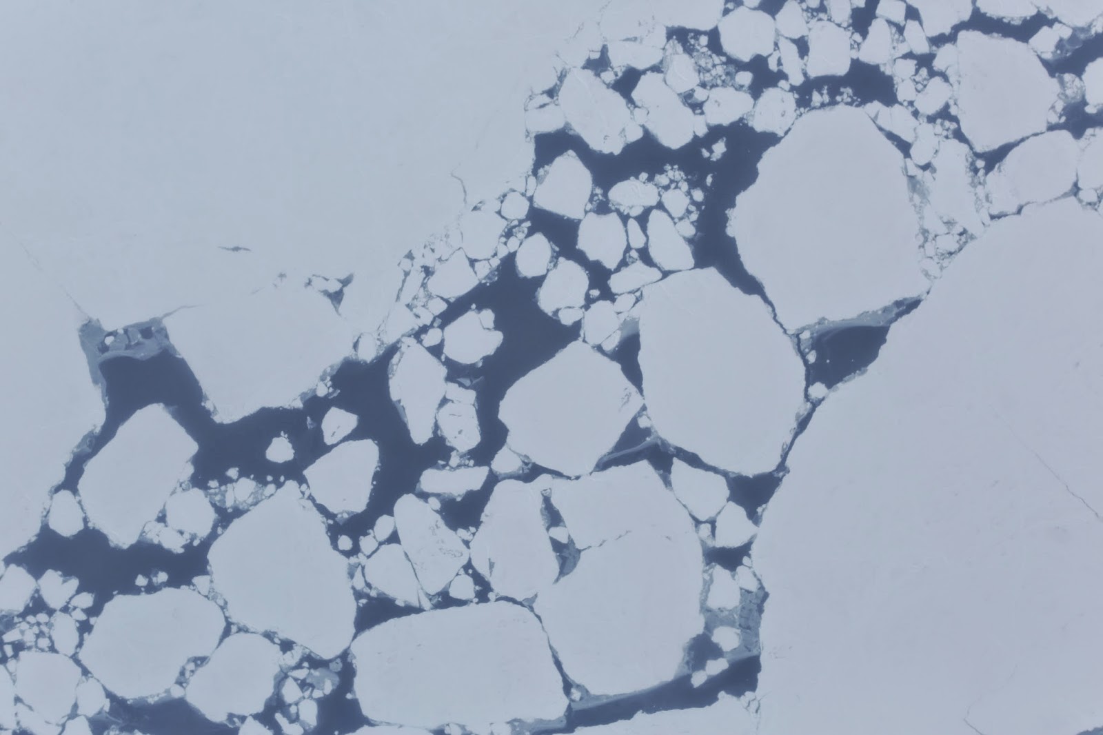
Broken sea ice captured during an ARISE flight over the Arctic Ocean by one of the C-130 Hercules’s onboard cameras. 

Credit: NASA

The Arctic Radiation, IceBridge Sea and Ice Experiment (ARISE), is a new NASA airborne campaign to collect data on thinning sea ice and measure cloud and atmospheric properties in the Arctic.

The campaign was designed to address questions about the relationship between retreating sea ice and the Arctic climate.

Arctic sea ice reflects sunlight away from Earth, moderating warming in the region. Loss of sea ice means more heat from the sun is absorbed by the ocean surface, adding to Arctic warming.

In addition, the larger amount of open water leads to more moisture in the air, which affects the formation of clouds that have their own effect on warming, either enhancing or reducing it.

Changes in more than 130 Alaskan glaciers are being surveyed by scientists at the University of Alaska-Fairbanks in a DHC-3 Otter as part of NASA’s multi-year Operation IceBridge.

Image Credit: Chris Larsen, University of Alaska-Fairbanks

ARISE will link clouds and sea ice in a way that improves our computer models of the Arctic,” said Tom Wagner, cryospheric sciences program manager at NASA Headquarters in Washington.

“Our goal is to better understand both the causes of Arctic ice loss and the connections to the overall Earth system.”

The ARISE campaign, using NASA’s C-130 Hercules aircraft from Wallops Flight Facility in Virginia, had its first science flight on Sept. 4 and has already carried out several surveys of sea ice and cloud conditions. The campaign is based in Fairbanks, Alaska.

“We are off to a great start collecting a timely and unique dataset to help better understand the potential influence of clouds on the Arctic climate as sea ice conditions change,” said William SmithARISE principal investigator at NASA’s Langley Research Center in Hampton, Virginia.

Carbon in Arctic Reservoirs Vulnerability Experiment (CARVE), is a five-year airborne research campaign that uses instruments aboard NASA aircraft to measure air and surface conditions and concentrations of gases like carbon dioxide, carbon monoxide and methane.

Using NASA’s C-23 Sherpa aircraftCARVE flies approximately two weeks per month from May to November.

Now that the mission is in its fourth year, researchers are building a detailed picture of how the land and atmosphere interact in the Arctic.

In high-latitude areas like Alaska, frozen ground known as permafrost can trap large amounts of carbon dioxide and methane produced by layers of decayed plant and animal matter.

As permafrost temperatures have been increasing faster than air temperatures in the Arctic, scientists have questioned whether these heat-trapping gases could be released into the atmosphere, increasing their global concentrations.

“The exchange of carbon between the land and the atmosphere is very important, but uncertain,” said Charles Miller, a scientist at NASA’s Jet Propulsion Laboratory in Pasadena, California, and principal investigator of CARVE.

Wednesday, May 28, 2014

NASA UAVSAR: An airborne research team focuses on Andean volcanoes

This false-colour image of Peru's Ubinas volcano was acquired on April 14, 2014, by NASA's Uninhabited Aerial Vehicle Synthetic Aperture Radar (UAVSAR)

Located about 100 miles (160 kilometers) from the city of Arequipa, Ubinas is Peru's most active volcano. 

UAVSAR flew exactly the same flight path over Ubinas in 2013. 

By combining the images from the two years, researchers will produce detailed maps of surface motions that can improve models of volcanic deformation. 

Credit: NASA/JPL-Caltech

A NASA-developed airborne imager called a synthetic aperture radar took a detailed look at volcanoes in Central and South America during an Earth science study in late April and early May 2014.

The Uninhabited Aerial Vehicle Synthetic Aperture Radar (UAVSAR), developed by NASA's Jet Propulsion Laboratory in Pasadena, California, was flown on NASA's C-20A.

The 29-day deployment ended May 6 when the aircraft returned to its base in Palmdale, California, after 19 flights totaling 97 hours in the air.

This is the second consecutive year the UAVSAR team has conducted a campaign to study sites in Central and South America.

Many of the flights imaged the Andean volcanic belt located in western South America.

"By combining images acquired in 2013 with the 2014 images, researchers will produce detailed surface motion measurements to improve volcanic deformation models," said Naiara Pinto, JPL's UAVSAR science coordinator.

NASA's C-20A features a high-precision autopilot designed and developed by engineers at NASA's Armstrong Flight Research Center, Edwards, California, allowing the aircraft to fly the same flight lines this spring as those flown in 2013 within 15 feet (4.5 meters) or closer.

With the autopilot engaged, the synthetic aperture radar is able to acquire repeat-pass data that can measure land-surface changes within fractions of an inch (centimeters).

NASA's C-20A aircraft crew preparing for flight from Tocumen International Airport in Panama City, Panama. 

The aircraft was deployed to Central and South America for a research study using JPL's UAVSAR airborne radar, located in an underbelly pod (note red cover). 

Credit: NASA/Armstrong Flight Research Center

In coordination with the volcano studies, the agency's C-20A gathered data over Amazonian forests in Peru, agricultural sites in Chile and glaciers on the Chilean/Argentinian border.

All of these research projects involve Latin American institutions, including universities and hazard monitoring agencies.

Tuesday, February 11, 2014

ESA Gaia coming into focus - NGC1818

An ESA Gaia test image of the young star cluster NGC1818 in the Large Magellanic Cloud, taken as part of calibration and testing before the science phase of the mission begins.

The field-of-view is 212 x 212 arcseconds and the image is approximately oriented with north up and east left. 

The integration time of the image was 2.85 seconds and the image covers an area less than 1% of the full ESA Gaia field of view.

Gaia's overall design is optimised for making precise position measurements and the primary mirrors of its twin telescopes are rectangular rather than round.

To best match the images delivered by the telescopes, the pixels in Gaia's focal plane detectors are then also rectangular. 

To produce this image of NGC1818, the image has been resampled onto square pixels. 

Furthermore, to maximise its sensitivity to very faint stars, Gaia's main camera does not use filters and provides wide-band intensity data, not true-colour images.

The false-colour scheme used here relates to intensity only. The real colours and spectral properties of the stars are measured by other Gaia instruments. 

Image courtesy ESA /DPAC /EADS Airbus DS.

ESA's billion-star surveyor Gaia is slowly being brought into focus.

This test image shows a dense cluster of stars in the Large Magellanic Cloud, a satellite galaxy of our Milky Way.

Once Gaia starts making routine measurements, it will generate truly enormous amounts of data.

To maximise the key science of the mission, only small 'cut-outs' centred on each of the stars it detects will be sent back to Earth for analysis.

This test picture, taken as part of commissioning the mission to 'fine tune' the behaviour of the instruments, is one of the first proper 'images' to be seen from Gaia, but ironically, it will also be one of the last, as Gaia's main scientific operational mode does not involve sending full images back to Earth.

Gaia was launched on 19 December 2013, and is orbiting around a virtual point in space called L2, 1.5 million kilometres from Earth.

Annotated diagram of the Payload Module
Gaia's goal is to create the most accurate map yet of the Milky Way.

It will make precise measurements of the positions and motions of about 1% of the total population of roughly 100 billion stars in our home Galaxy to help answer questions about its origin and evolution.

Repeatedly scanning the sky, Gaia will observe each of its billion stars an average of 70 times each over five years.

In addition to positions and motions, Gaia will also measure key physical properties of each star, including its brightness, temperature and chemical composition.

To achieve its goal, Gaia will spin slowly, sweeping its two telescopes across the entire sky and focusing the light from their separate fields simultaneously onto a single digital camera - the largest ever flown in space, with nearly a billion pixels.

But first, the telescopes must be aligned and focused, along with precise calibration of the instruments, a painstaking procedure that will take several months before Gaia is ready to enter its five-year operational phase.

Wednesday, October 17, 2012

Uranus: Keck observations brings weather into sharp focus

A paired picture of Uranus, the sharpest, most detailed picture of the distant planet to date, reveals a raft of new details about the planet's enigmatic atmosphere. 

The north pole of Uranus (to the right in the picture) is characterised by a swarm of storm-like convective features, and an unusual scalloped pattern of clouds encircles the planet's equator. 

The infrared image was taken using the Keck II telescope in Hawaii. 

Credit: Lawrence Sromovsky, Pat Fry, Heidi Hammel, Imke de Pater

In 1986, when Voyager swept past Uranus, the probe's portraits of the planet were "notoriously bland," disappointing scientists, yielding few new details of the planet and its atmosphere, and giving it a reputation as the most boring planet of the solar system.

Now, however, thanks to a new technique applied at the Keck Observatory, Uranus is coming into sharp focus through high-resolution infrared images, revealing in incredible detail the bizarre weather of the seventh planet from the sun.

The images were released in Reno, Nev. today (Oct. 17, 2012) at a meeting of the American Astronomical Society's Division of Planetary Sciences and provide the best look to date of Uranus's complex and enigmatic weather.

The planet's deep blue-green atmosphere is thick with hydrogen, helium and methane, Uranus's primary condensable gas.

Larry Sromovsky
Winds blow mainly east to west at speeds up to 560 miles per hour, in spite of the small amounts of energy available to drive them.

Its atmosphere is almost equal to Neptune's as the coldest in our solar system with cloud-top temperatures in the minus 360-degree Fahrenheit range, cold enough to freeze methane.

Large weather systems, which are probably much less violent than the storms we know on Earth, behave in bizarre ways on Uranus, explains Larry Sromovsky, a University of Wisconsin-Madison planetary scientist who led the new study using the Keck II telescope.

"Some of these weather systems," Sromovsky notes, "stay at fixed latitudes and undergo large variations in activity. Others are seen to drift toward the planet's equator while undergoing great changes in size and shape. Better measures of the wind fields that surround these massive weather systems are the key to unraveling their mysteries."


Imke de Pater
To get a better picture of atmospheric flow on Uranus, Sromovsky and colleagues Pat Fry, also of UW-Madison, Heidi Hammel of the Association of Universities for Research in Astronomy (AURA), and Imke de Pater of the University of California at Berkeley, used new infrared techniques to detect smaller, more widely distributed weather features whose movements can help scientists trace the planet's pattern of blustery winds.

"We're seeing some new things that before were buried in the noise," says Sromovsky, a senior staff scientist at UW-Madison's Space Science and Engineering Center.


Heidi Hammel
"My first reaction to these images was 'wow' and then my second reaction was WOW," says AURA's Heidi Hammel, a co-investigator on the new observations and an expert on the atmospheres of the solar system's outer planets.

"These images reveal an astonishing amount of complexity in Uranus's atmosphere. We knew the planet was active, but until now much of the activity was masked by noise in our data."

The complexity of Uranus's weather is puzzling, Sromovsky explains. The primary driving mechanism must be solar energy because there is no detectable internal energy source.

"But the sun is 900 times weaker there than on Earth because it is 30 times further from the sun, so you don't have the same intensity of solar energy driving the system," explains Sromovsky.

"Thus the atmosphere of Uranus must operate as a very efficient machine with very little dissipation. Yet the weather variations we see seem to defy that requirement."

The new Keck II pictures of the planet, according to Sromovsky, are the "most richly detailed views of Uranus yet obtained by any instrument on any observatory.

No other telescope could come close to producing this result." Sromovsky and his colleagues used Keck II, located on the summit of Hawaii's 14,000-foot extinct volcano Mauna Kea, to capture a series of images that, when combined, help increase the signal to noise ratio and thus tease out weather features that are otherwise obscured.

In two nights of observing under superb conditions, Sromovsky's group was able to obtain exposures of the planet that provide a clear view of the planet's cloudy features, including several new to science.

The group used two different filters in an effort to characterize cloud features at different altitudes. "The main objective was to find a larger number of cloud features by detecting those that were previously too subtle to be seen, so we could better define atmospheric motions," Sromovsky notes.

New features found by the Wisconsin group include a scalloped band of clouds just south of Uranus's equator and a swarm of small convective features in the north polar regions of the planet, features that have never been seen in the southern polar regions.

"This is a very asymmetric situation," says the Wisconsin scientist. "There is certainly something different going on in those two polar regions." One possible explanation, is that methane is pushed north by an atmospheric conveyor belt toward the pole where it wells up to form the convective features observed by Sromovsky's group.

"The 'popcorn' appearance of Uranus's pole reminds me very much of a Cassini image of Saturn," adds de Pater.

Read more here

Friday, April 30, 2010

NASA's Quest for space life a focus for the future

US space agency NASA is pondering 28 potential missions focusing on finding life beyond Earth inside our solar system, a US researcher said Wednesday.

"Astrobiology and the search for life is really central to what we should be doing next in the exploration of the solar system," Steve Squyres, a researcher at Cornell University in Ithaca, New York, said in a telephone press briefing.

"We are looking for a total of 28 different missions.... They cover everything from Mercury landers to fly-by of objects in deep outer space of the solar system -- and they are particularly relevant to looking for life," he explained.

Among other objects of interest: a three-stage Martian mission that would bring Martian soil samples back to Earth, said Squyres, who worked on the Spirit and Opportunity rovers, still active six years after their arrival on the Red Planet.

"Those samples might reveal a great deal of whether Mars once or today (has) forms of life," he said.

Another part of the mission would be to look at the origin of methane in the planet's atmosphere, and whether or not it is organic, he said.

Methane breaks down quickly in the Martian atmosphere, but scientists discovered plumes of methane on Mars in 2003, raising the prospect that the planet is not entirely dead.

"So we will send a mission potentially to look at the sources of the methane and consider the possibility that they could be from biological origins," Squyres added.

Further out in the solar system, scientists are very interested in Europa, a moon of Jupiter, he said.

"It's believed that Europa may have an ocean of liquid water underneath its icy crust. And we are looking at a Europa robot mission that would have, among other things, the capability to use a radar system that can penetrate through that ice, find the ocean if it exists, identify places where you might go to the surface to learn more" about the ocean, Squyres said.

Likewise Titan, a moon of Saturn, has scientists' attention.

It is "a moon we know to be very rich in organic materials. We are looking long term at a mission that will study Titan in great deal, including an orbiter, a balloon in Titan atmosphere and a lander to land in some of the lakes of liquid methane," the Cornell scientist added.

Another mission under consideration is one to return samples from a comet, the researcher said. "Comets are believed to be rich in organic materials, rich in building blocks of life. Most of the organic material on earth was probably delivered to earth by comets."

The number of projects needs to be whittled down, he said, before a recommendation will be made on what missions NASA should prioritise.