Showing posts with label climate. Show all posts

Wednesday, September 17, 2014

NASA Airborne Campaigns Focus on Climate Impacts in the Arctic

Flights are underway from Fairbanks, Alaska, with NASA’s C-130 Hercules aircraft to study the connection between retreating Arctic sea ice and climate change. 

Image Credit: NASA/Patrick Lynch

Over the past few decades, average global temperatures have been on the rise, and this warming is happening two to three times faster in the Arctic.

As the region’s summer comes to a close, NASA is hard at work studying how rising temperatures are affecting the Arctic.

NASA researchers this summer and fall are carrying out three Alaska-based airborne research campaigns aimed at measuring greenhouse gas concentrations near Earth’s surface, monitoring Alaskan glaciers, and collecting data on Arctic sea ice and clouds.

Observations from these NASA campaigns will give researchers a better understanding of how the Arctic is responding to rising temperatures.
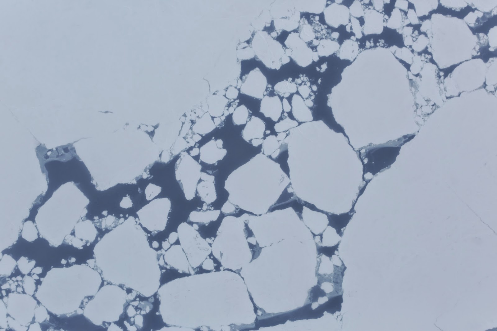
Broken sea ice captured during an ARISE flight over the Arctic Ocean by one of the C-130 Hercules’s onboard cameras. 

Credit: NASA

The Arctic Radiation, IceBridge Sea and Ice Experiment (ARISE), is a new NASA airborne campaign to collect data on thinning sea ice and measure cloud and atmospheric properties in the Arctic.

The campaign was designed to address questions about the relationship between retreating sea ice and the Arctic climate.

Arctic sea ice reflects sunlight away from Earth, moderating warming in the region. Loss of sea ice means more heat from the sun is absorbed by the ocean surface, adding to Arctic warming.

In addition, the larger amount of open water leads to more moisture in the air, which affects the formation of clouds that have their own effect on warming, either enhancing or reducing it.

Changes in more than 130 Alaskan glaciers are being surveyed by scientists at the University of Alaska-Fairbanks in a DHC-3 Otter as part of NASA’s multi-year Operation IceBridge.

Image Credit: Chris Larsen, University of Alaska-Fairbanks

ARISE will link clouds and sea ice in a way that improves our computer models of the Arctic,” said Tom Wagner, cryospheric sciences program manager at NASA Headquarters in Washington.

“Our goal is to better understand both the causes of Arctic ice loss and the connections to the overall Earth system.”

The ARISE campaign, using NASA’s C-130 Hercules aircraft from Wallops Flight Facility in Virginia, had its first science flight on Sept. 4 and has already carried out several surveys of sea ice and cloud conditions. The campaign is based in Fairbanks, Alaska.

“We are off to a great start collecting a timely and unique dataset to help better understand the potential influence of clouds on the Arctic climate as sea ice conditions change,” said William SmithARISE principal investigator at NASA’s Langley Research Center in Hampton, Virginia.

Carbon in Arctic Reservoirs Vulnerability Experiment (CARVE), is a five-year airborne research campaign that uses instruments aboard NASA aircraft to measure air and surface conditions and concentrations of gases like carbon dioxide, carbon monoxide and methane.

Using NASA’s C-23 Sherpa aircraftCARVE flies approximately two weeks per month from May to November.

Now that the mission is in its fourth year, researchers are building a detailed picture of how the land and atmosphere interact in the Arctic.

In high-latitude areas like Alaska, frozen ground known as permafrost can trap large amounts of carbon dioxide and methane produced by layers of decayed plant and animal matter.

As permafrost temperatures have been increasing faster than air temperatures in the Arctic, scientists have questioned whether these heat-trapping gases could be released into the atmosphere, increasing their global concentrations.

“The exchange of carbon between the land and the atmosphere is very important, but uncertain,” said Charles Miller, a scientist at NASA’s Jet Propulsion Laboratory in Pasadena, California, and principal investigator of CARVE.

Wednesday, September 10, 2014

Scientists concerned over the future of satellite-based research

Landsat 8 captured fine details of the lava flowing in Iceland between the Bardarbunga and Askja volcanoes.

Credit: NASANOAA.

The U.S. has more than 30 civilian, Earth-observing satellites circling the planet, providing scientists with a torrent of crucial environmental and climate information.

More satellites are on deck to launch in the next few years, but, according to an article in Chemical & Engineering News (C&EN), the weekly news magazine of the American Chemical Society, scientists have registered serious concerns over the lack of a long-term, cohesive vision for the scientific missions.

Jyllian Kemsley, a senior editor at C&EN, reports that satellites are marvels of technology.

From their orbits up to thousands of miles above the planet's surface, they collect Earthly measurements and beam down to scientists information they can't get any other way.

The satellites map cloud cover; they track snow and ice cover; they measure atmospheric carbon dioxide, a potent greenhouse gas; they detect chemical reactions in the atmosphere; they help meteorologists make weather predictions.

Future launches will undoubtedly add to the treasure trove of scientific data.

But some scientists say that despite the state-of-the-art sensors the satellites are equipped with, a short-sighted vision for the future, may cause the resulting science to suffer.

They say that the division between two agencies leading the way, NASA, which operates under a "first and best" vision, and the National Oceanic & Atmospheric Administration (NOAA), which takes the longer view, has created a "valley of death."

This gap hinders the use of NASA's research instruments for NOAA's desired sustained monitoring, which is critical to understanding complex systems of atmospheric chemistry and climate.

More information: Observing Earth - cen.acs.org/articles/92/i36/Observing-Earth.html

Monday, August 4, 2014

NASA Earth Observatory: New Studies Examine Climate/Vegetation Links

Two new spaceborne Earth-observing instruments will help scientists better understand how global forests and ecosystems are affected by changes in climate and land use change. 

This image of the Amazon rainforest is from a 2010 global map of the height of the world's forests based on multiple satellite datasets. 

Image courtesy NASA Earth Observatory.

NASA has selected proposals for two new instruments, including one from NASA's Jet Propulsion Laboratory, Pasadena, California, that will observe changes in global vegetation from the International Space Station.

UMD will develop the Global Ecosystem Dynamics Investigation Lidar (GEDI) for up to $94 million while JPL will build the ECOsystem Spaceborne Thermal Radiometer Experiment (ECOSTRESS) on Space Station for as much as $30 million, NASA said Wednesday.

The sensors will give scientists new ways to see how forests and ecosystems are affected by changes in climate or in land use.

A high-resolution, multiple-wavelength imaging spectrometer from JPL will study the effectiveness of water use by vegetation.

This instrument will be completed in 2018 and will not cost more than $30 million. A laser-based system from the University of Maryland, College Park, will observe the structure of forest canopy. This instrument will be completed in 2019 and will not cost more than $94 million.

John Grunsfeld
"We are excited to expand the use of the International Space Station to make critical Earth observations that will help scientists understand the diversity of forests and vegetation and their response to a changing climate," said John Grunsfeld, associate administrator of NASA's Science Mission Directorate in Washington.

"These innovative Earth Venture Instruments will join a growing suite of NASA Earth-observing sensors to be deployed to the station starting this year."

The instruments were competitively selected from 20 proposals submitted to NASA's Earth Venture Instrument program.

Part of the Earth System Science Pathfinder program (ESSP), Earth Venture investigations are small, targeted science investigations that complement NASA's larger research missions.

The National Research Council recommended in 2007 that NASA undertake this type of regularly solicited, quick-turnaround project. The program's first selection was awarded in 2010.

Simon Hook of JPL is the principal investigator for the ECOsystem Spaceborne Thermal Radiometer Experiment on Space Station (ECOSTRESS).

This project will use a high-resolution thermal infrared radiometer to measure plant evapotranspiration, the loss of water from growing leaves and evaporation from the soil.

These data will reveal how ecosystems change with climate and provide a critical link between the water cycle and effectiveness of plant growth, both natural and agricultural.

The ECOSTRESS team has extensive experience in development and analysis of thermal infrared spectroscopic images of Earth's surface.

Monday, February 3, 2014

NASA MODIS: Temperature Feedback magnifying climate warming in Arctic

Mosaic of images of the Arctic by MODIS. Credit: NASA

A team of researchers with the Max Planck Institute in Germany, has found that temperature feedback in the Arctic is causing more warming in that region than sea ice albedo feedback.

In their paper published in the journal Nature Geoscience, the team describes how plugging data into a computer simulation revealed a "layered cake" atmosphere that traps heat over the polar cap.

Scientists have known for several years that temperatures in the Arctic are rising faster (due to global warming) than for the rest of the planet—for the most part, most climatologists have attributed this to sea ice albedo—a feedback system where a small rise in temperature leads to melting of ice and snow.

Less ice and snow means less heat is reflected back into space, which means more warming occurs, and so on. In this new effort, the researchers suggest that while sea ice albedo is causing temperatures to rise, it's second to temperature feedback in overall impact.

To gain a better perspective on why Arctic temperatures are increasing so much, the researchers turned to highly sophisticated and data intensive climate computer models.

Their model showed a cap of cold layered air hovering over the Arctic, holding in the heat. The researchers believe their simulation accurately portrays what actually exists in the real Arctic.

Normally, they explain, changing weather patterns (such as thunderstorms) in other parts of the world keep atmospheric air churning, which in turn allows heat closer to the ground to be moved higher, allowing some of it to escape into space.

Things are very different in the Arctic—there is very little churning, which means that warm air close to ground (just one to two kilometers thick) remains where it is, trapped by a heavy layered atmosphere.

The simulation also helps to explain why Arctic warming is more pronounced in the winter than during other seasons—even less mixing of the air in the atmosphere occurs because the air is so cold.

The team reports that their simulations show that the temperature feedback that occurs in the Arctic is causing more average temperature increase than sea ice albedo, the second most critical factor in causing warming.

They have not used their findings to try to predict what sort of overall impact increasing Arctic temperatures might have on the rest of the planet, however, if the polar cap will melt completely, or if it does, when it might occur.

More information: Arctic amplification dominated by temperature feedbacks in contemporary climate models, Nature Geoscience (2014) DOI: 10.1038/ngeo2071

ESA ERS-2 satellite: Arctic lakes show climate on thin ice

Floating ice (light blue) and grounded ice (dark blue) in lakes of Alaska’s North Slope near Barrow, as seen by ESA’s ERS-2 satellite in 2011. 

Credit: Planetary Visions / University of Waterloo, Canada / ESA

Ice in northern Alaska's lakes during winter months is on the decline.

Twenty years of satellite radar imagery show how changes in our climate are affecting high-latitude environments.

Changes in air temperature and winter precipitation over the last five decades have affected the timing, duration and thickness of the ice cover on lakes in the Arctic.

In this region, warmer climate conditions result in thinner ice cover on shallow lakes and, consequently, a smaller fraction of lakes freezing all the way through during winter months.

The Alaskan Arctic coastal plain is covered in a great swathe of shallow lakes 

Credit: NASA USGS

These changes in ice cover affect the local and regional climate, the dynamics of the underlying permafrost and the availability of water for residential and industrial use throughout the winter.

They also alter the physical, thermal and chemical properties of the water, affecting the ecology dependent on them.

But the magnitude of these changes had not yet been comprehensively documented until now.

In a recent study of Alaska's North Slope, published in The Cryosphere, the ice regimes of shallow lakes were documented using radar images from ESA's ERS-1 and -2 satellites.

The study reveals a 22% decrease of 'grounded ice' – or ice frozen through to the lakebed – from 1991 to 2011. This is equivalent to an overall thinning of ice by 21–38 cm.

Cristina Surdu
"Prior to starting our analysis, we were expecting to find a decline in ice thickness and grounded ice based on our examination of temperature and precipitation records of the past five decades from the Barrow meteorological station," said Cristina Surdu, lead author of the study.

"At the end of the analysis, when looking at trend analysis results, we were stunned to observe such a dramatic ice decline during a period of only 20 years."

The greatest change was observed during late winter (April–May) over the 20-year period, which gradually decreased from 1991 to 2005.

The ice experienced a more abrupt decline during the final six years of the analysis, reaching its lowest in 2011.

ERS-2 was launched in 1995, four years after ERS-1, the first European Remote Sensing satellite. 

At the time, these two satellites were the most sophisticated European Earth observation spacecraft ever developed, delivering new information to study Earth's land, oceans, atmosphere and polar ice, as well as being called upon to monitor natural disasters such as earthquakes and floods. 

Credit: EADS Astrium

Monday, August 27, 2012

Scientists use A-Train satellites to measure how pollution particles affect clouds

Described as a satellite constellation, the 'A-Train' is shown in this artist's conception. 

The close timing and engineering of these satellites along a track means that they function as if they were all on the same platform. 

Data collected by the A-Train gave scientists in this CloudSat study more complete information on atmospheric particles around the globe. Photo: NASA.

Grabbing a virtual tiger by the tail, scientists led by researchers at Pacific Northwest National Laboratory directly linked a cloud's inclination to rain to its effects on the climate.

Using global satellite data and complex calculations, they were able—for the first time—to develop a proxy measurement for one of the most vexing questions in atmospheric science: how tiny particles in the atmosphere affect the amount of cloud.

Using this new metric, they showed that aerosols' effects on clouds are overestimated by as much as 30 percent in a global climate model. The results were published in the journal Geophysical Research Letters.

"Our study helps narrow the large aerosol-cloud interaction uncertainties in projections of future global warming," said Dr. Minghuai Wang, atmospheric scientist at PNNL and lead author of the study.

"Wide ranges of estimates in aerosol effects on clouds have made it challenging to understand how clouds really affect the climate." Understanding clouds and their effects on climate is a formidable challenge in trying to predict how the climate will change by the end of the century.

On the line are questions of future melting of the polar ice, drought and water shortages, and increases in extreme weather events. One particularly tough question is how tiny pollution-caused particles in the atmosphere will affect clouds.

This study shows how satellite observations can be used to hone in on aerosol effects on clouds and make it possible to better understand how clouds will affect climate.

"The use of satellite observations in studying climate processes like these is absolutely critical because it is the only way to obtain cloud and aerosol measurements over the whole globe," said Dr. Mikhail Ovchinnikov, PNNL atmospheric scientist and co-author of the study.

The study, led by PNNL scientists, constructed a new metric for rain frequency susceptibility, then closely correlated that metric to the aerosol effect on cloud amount, which is the total amount of water in the cloud and the cloud's size.

This metric, along with satellite measurements, was then used in three global climate models to find new ranges of cloud amount change due to pollution-caused aerosol particles, compared to current estimates.

The team, for the first time, used "A-Train" satellite observations which collect coincident global measurements of aerosols, clouds, and precipitation to develop a new metric, termed rain frequency susceptibility or "S-POP."

This metric provides a quantitative measure of the sensitivity of rain frequency to the amount of aerosols in clouds.

They showed how S-POP is closely correlated to aerosols' effects on cloud amount, using three global climate models, including a multi-scale aerosol climate model developed at PNNL (PNNL-MMF) that embeds a cloud-resolving model at each grid column of a host global climate model.

Finally, the relationship between S-POP and the aerosol effects on cloud amount from the global climate models together with the observed rain frequency susceptibility from A-Train observations were used to estimate aerosol effects on cloud amount in global climate models.

They showed that in one global model, the National Center for Atmospheric Research's Community Atmosphere Model version 5 (CAM5), aerosol effects on clouds were overestimated by 30 percent.

This research also provides a guide for the development and evaluation of new parameterizations, techniques to computationally represent complex small-scale systems, of aerosol effects on clouds in global climate models.

The researchers plan to apply S-POP to evaluate cloud amount based on rain frequency susceptibility in other global climate models, and guide further improvement of the aerosol indirect effects estimations in CAM5 and the PNNL-MMF multi-scale aerosol-climate model.

Read the paper: "Constraining Cloud Lifetime Effects of Aerosols Using A-Train Satellite Observations," Geophysical Research Letters 39:L15709. DOI:10.1029/2012GL052204

Friday, October 14, 2011

NASA NPP: New Type of Earth-Observing Satellite for Launch

NPP inside a clean room at Vandenberg Air Force Base in California. Credit: NASA/30th Communications Squadron, VAFB.

NASA is planning an Oct. 27 launch of the first Earth-observing satellite to measure both global climate changes and key weather variables.

The National Polar-orbiting Operational Environmental Satellite System Preparatory Project (NPP) is the first mission designed to collect critical data to improve weather forecasts in the short-term and increase our understanding of long-term climate change.

NPP continues observations of Earth from space that NASA has pioneered for more than 40 years.

NPP's five science instruments, including four new state-of-the-art sensors, will provide scientists with data to extend more than 30 key long-term datasets.

These records, which range from the ozone layer and land cover to atmospheric temperatures and ice cover, are critical for global change science.

"NPP's observations of a wide range of interconnected Earth properties and processes will give us the big picture of how our planet changes," said Jim Gleason, NPP project scientist at NASA's Goddard Space Flight Center in Greenbelt, Md.

"That will help us improve our computer models that predict future environmental conditions. Better predictions will let us make better decisions, whether it is as simple as taking an umbrella to work today or as complex as responding to a changing climate."

NPP serves as a bridge between NASA's Earth Observing System of satellites and the planned Joint Polar Satellite System (JPSS), which will collect climate and weather data. JPSS will be developed by NASA for the National Oceanic and Atmospheric Administration (NOAA).

NOAA meteorologists will incorporate NPP data into their weather prediction models to produce forecasts and warnings that will help emergency responders anticipate, monitor and react to many types of natural disasters.

"The timing of the NPP launch could hardly be more appropriate," said Louis W. Uccellini, director of NOAA's National Centers for Environmental Prediction in Camp Springs, Md. "With the many billion dollar weather disasters in 2011, NPP data is critical for accurate weather forecasts into the future."

A Delta II rocket will carry NPP into an orbit 512 miles above Earth's surface. Roughly the size of a mini-van, the spacecraft will orbit Earth's poles about 14 times a day. It will transmit data once each orbit to a ground station in Svalbard, Norway, and to direct broadcast receivers around the world.

NPP is set to launch from Space Launch Complex 2 at Vandenberg Air Force Base in California on Oct. 27. The launch window extends from 5:48 a.m. to 5:57 a.m. EDT.

The launch recently was delayed two days due to the repair of the Delta II's hydraulic system. The NPP spacecraft is scheduled to be transported to the launch pad for attachment to the Delta II on Oct. 12.

Monday, November 30, 2009

Arctic Expedition Investigates Climate Change and Alternative Fuels

Scientists from the Marine Biogeochemistry and Geology and Geophysics sections of the Naval Research Laboratory (NRL) organized and led a team of university and government scientists on an Arctic expedition to initiate methane hydrate exploration in the Beaufort Sea and determine the spatial variation of sediment contribution to Arctic climate change.

Utilising the U.S. Coast Guard Cutter Polar Sea as a research platform, three cross-shelf transects were surveyed and sampled off Alaska's North Slope at Hammerhead, Thetis Island and Halkett representing three regions of the Alaskan shelf.

The expedition integrated expertise in coastal geophysics, sediment geochemistry, dissolved and free methane fluxes through the water column and into the atmosphere, sediment and water column microbiology and biogeochemistry and detailed characterization of the sub-seafloor geology.

"The objective of the sampling is to help determine variations in the shallow sediment and water column methane sources, methane cycling and the subsequent flux to the atmosphere," said Richard Coffin, chief scientist, NRL Chemistry Division.

The content, location and distribution of methane in hydrate is variable and controlled by geothermal gradients and biological and thermal methane production. Large deposits of methane hydrates, frozen mixtures of hydrocarbon gas (mostly methane) and water, occur over large areas of the ocean floor. International research has begun with a primary goal of obtaining the methane in these hydrates as an energy source.

During the 12-day expedition, Methane In The Arctic Shelf and Slope (MITAS-1), the crew conducted 34 conductivity-temperature-depth (CTD) water column casts using a rosette of Niskin bottles and collected sediment samples from 14 piston cores, three vibrocores and 20 multicores.

Regions selected for this study were based on the review of Minerals Management Service and U.S. Geologic Survey (USGS) seismic data with specific sample locations decided onboard through review of the 3.5 Kilohertz (kHz) sub-bottom profiler data.

The MITAS-1 crew focused on six primary goals to include:

+ Acquire and integrate seismic, acoustic, temperature, geochemical, and lithostratigraphic data for evaluation of deep sediment hydrate distributions.

+ Estimate spatial variation and controls on the vertical methane flux as it relates to variations in lithostratigraphy, geologic structures, water column temperatures, heat flow, seismic and acoustic profiles, and water depth.

+ Develop and calibrate models to evaluate sediment hydrate loading, hydrate destabilization through warming, and the fate of methane after destabilization.

+ Determine and model the transport of methane from the sediment through the water column into the atmosphere.

+ Study the control of total methane emissions by microbial methane consumption in the sediment and in the water column.

+ Study the contribution of methane to the benthic and pelagic carbon cycling.

The expedition was supported by NRL, Office of Naval Research (ONR), Department of Energy (DoE), Royal Netherlands Institute for Sea Research (NIOZ), French Research Institute for Exploitation of the Sea (IFREMER) and the German Leibniz Institute of Marine Sciences (IFM-Geomar). Future expeditions will also include scientists from Scotland's Herriot-Watt University, Norway's University of Bergen and GNS Science of New Zealand.

"Our project is intended to initiate a long-term collaboration in future expeditions in the Beaufort Sea and other regions of the Arctic Ocean," said Coffin.

Tuesday, November 10, 2009

ESA Climate Studies - Aerosol Gas Survey

Aerosol optical depth measured by SEVIRI. Climate studies to benefit from 12 years of satellite aerosol data

Aerosols, very small particles suspended in the air, play an important role in the global climate balance and in regulating climate change.

They are one of the greatest sources of uncertainty in climate change models. ESA's GlobAerosol project has been making the most of European satellite capabilities to monitor them.

Using data from the Along Track Scanning Radiometer-2 on the ERS-2 satellite, the Advanced Along Track Scanning Radiometer and the Medium Resolution Imaging Spectrometer on Envisat and the Spinning Enhanced Visible & InfraRed Imager (SEVIRI) instrument on the Meteosat Second Generation, GlobAerosol has produced a global aerosol dataset going back to 1995. The full dataset is available on the GlobAerosol website.

Some aerosols occur naturally, originating from sea-spray, wind-blown dust, volcanic eruptions and biochemical emissions from oceans and forests, while others are produced through emissions from industrial pollution, fossil-fuel burning, man-made forest fires and agriculture.

Wind-blown dust
They are important because they strongly affect Earth’s energy balance in two ways: they scatter and absorb sunlight and infrared emission from Earth's surface, and act as condensation nuclei for the formation of cloud droplets. According to the Intergovernmental Panel on Climate Change, these effects tend to cool the planet to almost the same degree as carbon dioxide emissions warm it. These estimates are uncertain, however, so more data are needed.

Satellite data can provide essential information on the global distribution of aerosols to help understand the impact of these processes for the purposes of predicting weather and climate as well as for monitoring the transport of industrial pollution.

Monday, October 12, 2009

Greenpeace Climate protestors climb onto UK Parliament roof

Climate protest on Parliament roof - , - Latest news & weather forecasts - MSN News UK

Climate protest on Parliament roof

Environmental campaigners stage a protest on the roof of the Houses of Parliament


More than 20 environmental campaigners are still on the roof of the Palace of Westminster in a protest over climate change, while another 20 are being held by police.

The Greenpeace activists hope to greet politicians as they arrive for the start of Parliament with a 12-point manifesto calling for zero carbon emissions by 2030, a stop to airport expansion, more wind power and new pollution taxes.

The group is looking to upcoming climate talks in Copenhagen as the ideal opportunity to address the climate problem.

The demonstrators climbed on to the roof, ramparts and a turret on top of Westminster Hall at the weekend, unfurling yellow banners which read: "Change the politics, save the climate".

They said there was little resistance from police when they moved quickly to prop ladders against the wall and climb on to the roof.

On the pavement below, Greenpeace campaigner Robin Oakley said morale was high and the group planned to stay as long as possible.

He said: "Our volunteers have spent the night on the roof and have woken up to a dawn where they are determined to get the message across to MPs who are back today."

The ease with which protesters gained access to the site raised concerns over security.
Environmental campaigners stage a protest on the roof of the Houses of Parliament

Shared via AddThis

Wednesday, February 25, 2009

NASA OCO satellite crashes and burns

Satellite failure clouds future of US climate science

gloryblog.jpg

The failure of NASA's Orbiting Carbon Observatory (OCO) is a loss to climate science, but that loss could be doubly compounded if engineers can't correct what went wrong in time for NASA's next climate satellite to fly later this year.

That satellite, known as the Glory mission, is currently set to launch in November, but it's now on hold pending the results of the OCO investigation. Whereas OCO was build to measure greenhouse gases, Glory is designed to study the effects of aerosols on clouds. This has been called the "missing link" of climate science, and it's information that is needed as soon as possible to refine global climate models.

It's well known that clouds reflect sunlight, which has a net effect of making the Earth cooler. It's also known that minute particles called aerosols often become the nuclei around which water droplets form in clouds. But what nobody understands is exactly how much humans are affecting the clouds with all the aerosols we generate through combustion, agriculture and other dust-raising activities.

So a delay in getting Glory off the ground means a delay in filling in this crucial piece of the climate puzzle. But wait - it gets worse.

One of the instruments on Glory is the "Total Irradiance Monitor" (TIM). Its job is to measure the total light output of the Sun to a degree of precision that is simply unachievable on the ground. This is important because sunlight is the key input into global climate and it drives the whole system. The fact that some climate sceptics still site changes in the Sun's energy output as responsible for climate change speaks to the fact that we don't have a good handle on what the Sun is likely to be doing long-term and more data are urgently needed.

Solar irradiance has been measured continuously from space for about the last 30 years. But during the 1980's coverage was insufficient and the calibration is not good between instruments that measured the Sun before and after this period. The deficit has led to disputes and to opposite conclusions about the long-term trend in solar irradiance.

Right now the best instrument for measuring solar irradiance is on the SORCE satellite, which was launched in 2003 and is now well past its nominal mission lifetime.

The TIM instrument on Glory is a descendant of this device and scientists involved with the mission say it's vital for the two instruments to observe the Sun together for at least six months to preserve the continuity of the 30-year solar record. If not, says TIM instrument scientist Greg Kopp of the University of Colorado, "it puts the whole record in jeopardy".

That would mean we might not be sure if the Sun is getting brighter, dimmer or staying the same in the coming decades, which is essential information for climate modelling and policy-making.

Glory will be launched on the same model of Taurus XL rocket that failed to place OCO into orbit today. The likely cause of the failure - a fairing that decided not to separate - has been established. What is not clear is whether this will require changes that could push back the launch of Glory into 2010 or beyond. Obviously scientists are hoping this will not be the case, and that any changes can be made in parallel with their own preparations for launch. On the other hand, another failure would be disastrous.