Showing posts with label environment. Show all posts

Wednesday, September 10, 2014

Scientists concerned over the future of satellite-based research

Landsat 8 captured fine details of the lava flowing in Iceland between the Bardarbunga and Askja volcanoes.

Credit: NASANOAA.

The U.S. has more than 30 civilian, Earth-observing satellites circling the planet, providing scientists with a torrent of crucial environmental and climate information.

More satellites are on deck to launch in the next few years, but, according to an article in Chemical & Engineering News (C&EN), the weekly news magazine of the American Chemical Society, scientists have registered serious concerns over the lack of a long-term, cohesive vision for the scientific missions.

Jyllian Kemsley, a senior editor at C&EN, reports that satellites are marvels of technology.

From their orbits up to thousands of miles above the planet's surface, they collect Earthly measurements and beam down to scientists information they can't get any other way.

The satellites map cloud cover; they track snow and ice cover; they measure atmospheric carbon dioxide, a potent greenhouse gas; they detect chemical reactions in the atmosphere; they help meteorologists make weather predictions.

Future launches will undoubtedly add to the treasure trove of scientific data.

But some scientists say that despite the state-of-the-art sensors the satellites are equipped with, a short-sighted vision for the future, may cause the resulting science to suffer.

They say that the division between two agencies leading the way, NASA, which operates under a "first and best" vision, and the National Oceanic & Atmospheric Administration (NOAA), which takes the longer view, has created a "valley of death."

This gap hinders the use of NASA's research instruments for NOAA's desired sustained monitoring, which is critical to understanding complex systems of atmospheric chemistry and climate.

More information: Observing Earth - cen.acs.org/articles/92/i36/Observing-Earth.html

Tuesday, August 21, 2012

Nasa Mars Rover Curiosity: Wheel Wiggles but Wind Sensor is damaged

After wiggling its wheels in the Martian soil, the Mars rover Curiosity was pronounced fit to take its first test drive tomorrow.

But amidst the fanfare comes news of the rover's first science casualty.

During shakedown tests this week, the team discovered that a wind sensor on the rover's mast was damaged.

The instrument is basically an exposed circuit board attached to Curiosity's "neck" as part of the Rover Environment Monitoring Station, or REMS.

This weather station includes a suite of sensors that will measure wind speed and direction, temperature, air pressure, humidity and ultraviolet radiation throughout each day of the mission.

One of two wind sensors on REMS sent back nonsensical data. Inspections with Curiosity's cameras revealed that some of its wires are broken, and there's little hope of finding a workaround.

The team thinks the device could have been damaged in a hail of rocks during the rover's death-defying landing.

As the rover was being lowered to the ground on the Sky Crane, the plumes stirred up winds that tossed small rocks into the air. Those rocks came raining back down onto the rover's deck, where its neck-like mast was still folded down.

"Putting two and two together, we've come up with idea that some of these rocks could have fallen on the circuit boards and caused potential damage," said deputy project scientist Ashwin Vasavada in a news conference on 21 August.

"These are pretty fragile devices," Vasavada added. "That's the price we pay for flying the next generation of wind sensor."


It could have been worse. The damaged sensor was a backup, designed to get extra measurements when the wind was coming from directly behind the rover.

The other, forward-facing sensor is "working perfectly", says REMS principal investigator Javier Gomez-Elvira.

"We still have the capability to measure wind from the front, so we have almost all the capability that we had from the beginning."

Because Curiosity's nuclear power source keeps it warm at night and through the winter, REMS will give the first direct weather measurements throughout the entire Martian year, and the first measurements of a full Martian day since the Viking 1 lander stopped responding in 1982.

Monitoring the modern weather will also illuminate the planet's past. Gale Crater, where the rover landed, was carved out by wind billions of years ago, and the five-kilometre-high mountain at its centre was probably also shaped by wind.

More recently, wind sloshing back and forth in the crater's basin formed dark sand dunes that the rover will have to dodge to get to the mountain's foothills.

Friday, July 6, 2012

Human Destruction of Habitat and Earth's Resources Accelerates!

A scavenger bobs around on a giant ocean of rubbish on one of the world's most polluted waterways.

The makeshift vessel carves a path through rubbish on the River Sentiong in Jakarta, Indonesia.

The river, which winds through the capital city, has been dubbed the 'River of Refuse'.

Picture: Sinar Sakti Images / Barcroft Media

On 6 June 2007, the city administration introduced the Waterway (officially Angkutan Sungai), a new river boat service along the Ciliwung River. 

However, because of the large amount of floating garbage which kept jamming the propeller, it is no longer in service. 


Wednesday, March 28, 2012

Nasa: Gulf Stream around North America

This NASA image shows the Gulf Stream around North America.

It is taken from Perpetual Ocean, a visualisation of some of the world's surface ocean currents from June 2005 through December 2007.

Picture: NASA/Reuters


Friday, March 9, 2012

Nasa Astronauts' view of Lake Powell, Utah

Great view of Lake Powell, Utah and Wahweap Bay.

Antelope and Navajo Canyons and Glen Canyon Dam are also visible.

Thursday, March 1, 2012

NASA - Spray Bars to Help Test Engine Icing

Ron Colantonio (left), manager of the Atmospheric Environment Safety Technologies Project at NASA’s Glenn Research Center in Cleveland, discussed with NASA Administrator Charlie Bolden the latest testing and research on airplane engine icing during the administrator's February 2012 visit to the center.

Colantonio showed Bolden how a large horizontal array of spray bars, such as those pictured, would emit a cloud of ice crystals in high-altitude, low pressure conditions that match those an airliner might experience in flight.

NASA scientists are mounting a research campaign using flight and ground tests to solve this aviation mystery, in which ice crystals associated with warm-weather storms can be ingested into the core of a hot jet engine, melt and then re-freeze.

As larger amounts of ice build up, some of the ice can break off and cause damage inside the engine, or melt and cause the engine to lose power or shut down altogether in a flameout.

Part of the research effort involves using the spray bars to simulate the icing conditions in engines on the ground at the Propulsion Systems Laboratory at Glenn. Eventually, a full-scale engine will be mounted opposite the bar array.

Image Credit: NASA/Marvin Smith

Tuesday, February 7, 2012

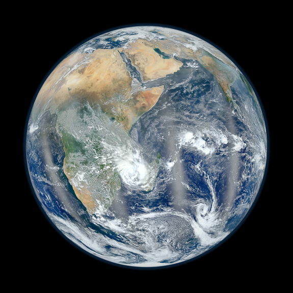
Earth: Our Fragile Pale Blue Dot


Our marbled earth to city lights from space.

Credit: NASA/NOAA

Friday, October 7, 2011

ESA ENVISAT Image: Spitrsbergen, Norway's Glacier island

Spitsbergen, Norway’s largest island, is pictured in this image, acquired on 6 September 2011 by Envisat’s Advanced Synthetic Aperture Radar (ASAR). 

Bordered by the Arctic Ocean to its north and the Greenland Sea to its west, Spitsbergen is the largest and only permanently populated island of the Svalbard archipelago.

Credits: ESA
Bordered by the Arctic Ocean to its north and the Greenland Sea to its west, Spitsbergen is the largest and only permanently populated island of the Svalbard archipelago.

The island has many glaciers, mountains and fjords – long inlets created by glacial activity.

Because of its high latitude, average summer temperatures are between 4 °C and 6 °C, while winters drop to around −20 °C. The North Atlantic Current, however, gives Spitsbergen significantly higher temperatures than other places at the same latitude.

Arctic foxes, reindeer and polar bears roam the land here. The surrounding waters are home to whales, dolphins and walruses.

This image was acquired on 6 September by Envisat’s Advanced Synthetic Aperture Radar. 

Wednesday, August 24, 2011

ESA ERS-2: Lowering orbit continues

Like its predecessor ERS-1 (launched in July 1991 by Ariane 4), the ERS-2 satellite (launched on 21 April 1995 also by Ariane 4) monitored the ground day and night under all weather conditions thanks to its powerful sharp-eyed, cloud-piercing radars. 

ERS-2 also carried an instrument to help monitor the ozone layer.

Credits: ESA

The orbit of ESA’s retired ERS-2 observation satellite is being lowered to reduce the risk of collision with other satellites or space debris. The goal is to leave it well below most operating polar satellites by the end of August.

The first in a series of thruster firings, each lasting about 300 seconds, was commanded by the mission control team at ESA’s European Space Operations Centre in Germany on 6 July to lower the orbit of the Agency’s veteran satellite.

The burns have since lowered the satellite from its initial 785 km-high orbit to about 700 km.

Engineers are closely monitoring the manoeuvres via ESA’s ground station in Kourou, French Guiana, and the Malindi station in Kenya.

“We achieved our first 700 km target altitude on 27 July,” said Frank Diekmann, the ERS-2 operations manager.

“Between now and the end of August, ERS-2 will be brought down to about 570 km, where the risk of collision with other satellites or space debris is drastically reduced.”

The last phase, called ‘passivation’, will begin late in August or early September. During this phase, a number of long burns will deplete remaining fuel and, finally, the batteries will be disconnected and the transmitters switched off.

Reentry of the satellite into Earth’s atmosphere is projected to occur within 25 years. Continued tracking will allow prediction of the reentry time and path.

Wednesday, August 10, 2011

Revealed: Orange gunk that plagued village was eggs

Scientists have identified an orange-colored gunk that appeared along the shore of a remote Alaska village as millions of microscopic eggs filled with fatty droplets.

But the mystery is not quite solved. Officials with the National Oceanic and Atmospheric Administration said Monday they don't know for sure what species the eggs are, although they believe they are some kind of crustacean eggs or embryos.

They also don't know if the eggs are toxic, and that worries many of the 374 residents of Kivalina, an Inupiat Eskimo community located at the tip of an 8-mile barrier reef on Alaska's northwest coast.

There's been at least one report of dead minnows found in the lagoon of the village the night the eggs appeared last week. Residents also are worried about the community's dwindling reserves in village water tanks even though the orange mass has dissipated from the lagoon and Wulik River, city administrator Janet Mitchell said.

"It seems to be all gone," she said. "But if they're microscopic eggs, who's to say they're not still in the river?"

Image: A magnified close-up of a sample of orange gunk tested by NOAA scientists in Juneau, Alaska

This photo provided by the National Oceanic and Atmospheric Administration shows a magnified close-up of the orange gunk. Scientists also don't know why the unidentified eggs suddenly emerged on the shores of Kivalina last week. Villagers say they've never seen such a phenomenon before.

"We'll probably find some clues, but we'll likely never have a definitive answer on that," NOAA spokeswoman Julie Speegle said.

Samples are being sent to a NOAA laboratory in Charleston, South Carolina, for further analysis. The Alaska Department of Environmental Conservation also sent samples Monday to the Institute for Marine Science at the University of Alaska Fairbanks.

Gooey, slimy substance
Kivalina residents live largely off the land, and many are worried about the effect on some wildlife and plants from the goo, which turned powdery once it dried — and probably went airborne.

Mitchell said some people went berry picking over the weekend, but couldn't tell if the goo was on the fruit, called salmonberries, which are the same color of the eggs. The caribou are in the region now, but she doesn't believe the migrating animals pose much risk as a food source.

The eggs were found on at least one roof and in buckets set all over the village to collect rain water. City Councilwoman Frances Douglas said the gooey, slimy substance was widely spread in streaks along the Wulik River and the lagoon, which is a half mile wide and six miles long. Orangey water was reported from as far away as the village of Buckland, southeast of Kivalina.

Douglas estimated the volume of eggs she could see "in excess of a thousand gallons, easily."

Revealed: Orange gunk that plagued village was eggs

Friday, July 8, 2011

Mercury vapour released from broken energy saving light bulbs can exceed safe exposure levels

Once broken, a compact fluorescent light bulb (CFL) or energy saving light bulbs continuously releases mercury vapour into the air for weeks to months, and the total amount can exceed safe human exposure levels in a poorly ventilated room, according to study results reported in Environmental Engineering Science, a peer-reviewed online only journal published monthly by Mary Ann Liebert, Inc.

The amount of liquid mercury (Hg) that leaches from a broken compact fluorescent lamp (CFL) is lower than the level allowed by the U.S. Environmental Protection Agency (EPA), so CFLs are not considered hazardous waste.

However, Yadong Li and Li Jin, Jackson State University (Jackson, MS) report that the total amount of Hg vapour released from a broken CFL over time can be higher than the amount considered safe for human exposure.

They document their findings in the article "Environmental Release of Mercury from Broken Compact Fluorescent Lamps."

As people can readily inhale vapour-phase mercury, the authors suggest rapid removal of broken CFLs and adequate ventilation, as well as suitable packaging to minimize the risk of breakage of CFLs and to retain Hg vapour if they do break, thereby limiting human exposure.

Tests of eight different brands of CFLs and four different wattages revealed that Hg content varies significantly from brand to brand. To determine the amount of Hg released by a broken CFL, Li and Jin used standard procedures developed by the EPA to measure leaching of mercury in liquids and used an emission monitoring system to detect Hg vapour.

"This paper is a very nice holistic analysis of potential risks associated with mercury release from broken CFLs and points to potential human health threats that have not always been considered," according to Domenico Grasso, PhD, Editor-in-Chief and Vice President for Research, Dean of the Graduate College, University of Vermont (Burlington).

Tuesday, July 5, 2011

ESA ERS-2: environment satellite retires

After 16 years spent gathering a wealth of data that has revolutionised our understanding of Earth, ESA's veteran ERS-2 satellite is being retired.

This pioneering mission has not only advanced science, but also forged the technologies we now rely on for monitoring our planet.

ERS-2 was launched in 1995, following its sister, the first European Remote Sensing satellite, which was launched four years earlier.

Carrying suites of sophisticated instruments to study the complexities of the atmosphere, land, oceans and polar ice, these two missions were the most advanced of their time, putting Europe firmly at the forefront of Earth observation.

The twin satellites were identical, apart from ERS-2's additional instrument to monitor ozone in the atmosphere. Both exceeded their design lifetime by far, together delivering a 20-year stream of continuous data.

In 2000, ERS-1 unexpectedly stopped working and now it is time to bid farewell to ERS-2 before it succumbs to a similar fate.


ERS-2 in the cleanroom

ERS-2 in the cleanroom
To avoid ERS-2 ending up as a piece of space debris, ESA will take the satellite out of service by bringing it down to a lower orbit while there is still sufficient fuel to make the careful manoeuvres.

The decision to retire ERS-2 was not taken lightly, but after orbiting Earth almost 85 000 times – travelling 3.8 billion km – the risk that the satellite could lose power at any time is clearly high.

Thursday, July 29, 2010

ESA Envisat to become bigest piece of Space Debris

The European Space Agency is set to become the owner of what could become the most dangerous piece of space debris orbiting the Earth, officials say.

The agency will take control of the Envisat satellite, at more than 17,000 pounds the biggest non-military Earth observation satellite ever built, SPACE.com reported Tuesday.

When the Envisat mission ends in 2013, the retired satellite will become a huge "space junk" problem that will not go away for 150 years, experts say.

That is how long it will take for Envisat to be gradually pulled into the Earth's atmosphere, they predict.

In January, the upper stage of a Chinese rocket almost collided with Envisat, and ground controllers had to use the satellite's thrusters to move it out of the way.

Once Envisat is retired in three years, such maneuvers will no longer be possible, scientists say.

Had the collision happened, it would have polluted a highly populated portion of low-Earth orbit with large amounts of space debris, Heiner Klinkrad of ESA's space debris office said.

Saturday, May 22, 2010

Polluted by profit: Johann Hari on the real Climategate - Climate Change, Environment

Polluted by profit: Johann Hari on the real Climategate - Climate Change, Environment - The Independent

Why did America's leading environmental groups jet to Copenhagen to lobby for policies that will lead to the faster death of the rainforests – and runaway global warming? Why are their staff dismissing the only real solutions to climate change as "unworkable" and "unrealistic"? Why are they clambering into corporate "partnerships" with BP, which is responsible for the worst oil spill in living memory?

At first glance, these questions will seem bizarre. Groups such as Conservation International (CI) and the Nature Conservancy (TNC) are among the most trusted "brands" in the world, pledged to protect and defend nature.

Yet as we confront the biggest ecological crisis in human history, many of the green organisations meant to be leading the fight are busy shovelling up hard cash from the world's worst polluters – and simultaneously burying science-based environmentalism.

In the middle of a swirl of bogus climate scandals trumped up by deniers, here is the real Climategate, waiting to be exposed.

Read the full article by following the link

Tuesday, April 27, 2010

ESA’s Envisat monitors oil spill

ESA Portal - ESA’s Envisat monitors oil spill

These ESA Envisat images capture the oil that is spilling into the Gulf of Mexico after a drilling rig exploded and sank off the coasts of Louisiana and Mississippi, USA, on 22 April.

In the black-and-white radar image the oil spill is visible as a dark grey whirl in the bottom right, while in the optical image it is seen as a white whirl. The Mississippi Delta is at top left, and the Delta National Wildlife Refuge extends out into the Gulf.
Officials report that about 1000 barrels of oil a day is escaping from a damaged oil well located 1.5 km under the drilling rig. By yesterday afternoon, the spill was covering an area some 77 km long and 63 km wide.

Monday, December 21, 2009

Pet Pollution: The devastating impact of man's best friend

Man's best friend could be one of the environment's worst enemies, according to a new study which says the carbon pawprint of a pet dog is more than double that of a gas-guzzling sports utility vehicle.

But the revelation in the book "Time to Eat the Dog: The Real Guide to Sustainable Living" by New Zealanders Robert and Brenda Vale has angered pet owners who feel they are being singled out as troublemakers.

The Vales, specialists in sustainable living at Victoria University of Wellington, analysed popular brands of pet food and calculated that a medium-sized dog eats around 164 kilos (360 pounds) of meat and 95 kilos of cereal a year.

Combine the land required to generate its food and a "medium" sized dog has an annual footprint of 0.84 hectares (2.07 acres) -- around twice the 0.41 hectares required by a 4x4 driving 10,000 kilometres (6,200 miles) a year, including energy to build the car.

To confirm the results, the New Scientist magazine asked John Barrett at the Stockholm Environment Institute in York, Britain, to calculate eco-pawprints based on his own data. The results were essentially the same.

"Owning a dog really is quite an extravagance, mainly because of the carbon footprint of meat," Barrett said.

Other animals aren't much better for the environment, the Vales say.

Cats have an eco-footprint of about 0.15 hectares, slightly less than driving a Volkswagen Golf for a year, while two hamsters equates to a plasma television and even the humble goldfish burns energy equivalent to two mobile telephones.

But Reha Huttin, president of France's 30 Million Friends animal rights foundation says the human impact of eliminating pets would be equally devastating.

"Pets are anti-depressants, they help us cope with stress, they are good for the elderly," Huttin told AFP.

"Everyone should work out their own environmental impact. I should be allowed to say that I walk instead of using my car and that I don't eat meat, so why shouldn't I be allowed to have a little cat to alleviate my loneliness?"

-- 'Rabbits are good, provided you eat them' -- Which brings us back to the French!

Friday, October 2, 2009

Illegal toxic waste spotted from space - environment - New Scientist

Illegal toxic waste spotted from space - environment - New Scientist

MOVE over Erin Brockovich. Today's environmental detectives can use radar, helicopters and even satellite images to help them spot illegal toxic waste dumps and help catch those responsible.

Ironically, the tightening of restrictions on waste disposal and the enforcement of new recycling laws have made illegal dumping more likely, turning it into big business for the criminals involved.

The trouble is digging up suspect dumps to investigate their contents can release toxins into local water supplies. But with new remote-sensing techniques, such as ground-penetrating radar (GPR), you can find toxic trash without disturbing the soil. Instead, you bounce microwaves off buried materials and the strength of returning signals provides clues to what they are.

Alastair Ruffell, a forensic geologist at Queen's University, Belfast in the UK, has used GPR in 17 cases for the environment agencies of Scotland, the Republic of Ireland and Northern Ireland. Most are ongoing, however three have resulted in the culprits being jailed and fined.

Ruffell's latest research shows that geophysical techniques can be used to characterise the waste (Environmental Forensics, DOI: 10.1080/15275920903130230). GPR surveys suggested the presence of a highly conductive waste such as farmyard slurry in a peat bog in Northern Ireland, simply because the suspect pocket in the bog reflected no microwaves.

Shared via AddThis