Showing posts with label impacts. Show all posts

Wednesday, September 17, 2014

NASA Airborne Campaigns Focus on Climate Impacts in the Arctic

Flights are underway from Fairbanks, Alaska, with NASA’s C-130 Hercules aircraft to study the connection between retreating Arctic sea ice and climate change. 

Image Credit: NASA/Patrick Lynch

Over the past few decades, average global temperatures have been on the rise, and this warming is happening two to three times faster in the Arctic.

As the region’s summer comes to a close, NASA is hard at work studying how rising temperatures are affecting the Arctic.

NASA researchers this summer and fall are carrying out three Alaska-based airborne research campaigns aimed at measuring greenhouse gas concentrations near Earth’s surface, monitoring Alaskan glaciers, and collecting data on Arctic sea ice and clouds.

Observations from these NASA campaigns will give researchers a better understanding of how the Arctic is responding to rising temperatures.
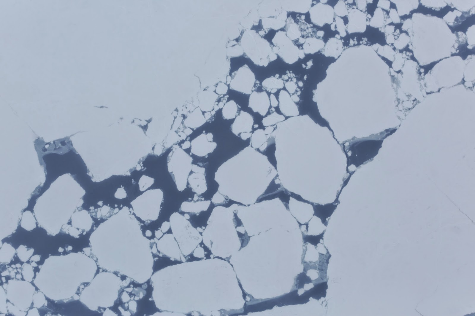
Broken sea ice captured during an ARISE flight over the Arctic Ocean by one of the C-130 Hercules’s onboard cameras. 

Credit: NASA

The Arctic Radiation, IceBridge Sea and Ice Experiment (ARISE), is a new NASA airborne campaign to collect data on thinning sea ice and measure cloud and atmospheric properties in the Arctic.

The campaign was designed to address questions about the relationship between retreating sea ice and the Arctic climate.

Arctic sea ice reflects sunlight away from Earth, moderating warming in the region. Loss of sea ice means more heat from the sun is absorbed by the ocean surface, adding to Arctic warming.

In addition, the larger amount of open water leads to more moisture in the air, which affects the formation of clouds that have their own effect on warming, either enhancing or reducing it.

Changes in more than 130 Alaskan glaciers are being surveyed by scientists at the University of Alaska-Fairbanks in a DHC-3 Otter as part of NASA’s multi-year Operation IceBridge.

Image Credit: Chris Larsen, University of Alaska-Fairbanks

“ARISE will link clouds and sea ice in a way that improves our computer models of the Arctic,” said Tom Wagner, cryospheric sciences program manager at NASA Headquarters in Washington.

“Our goal is to better understand both the causes of Arctic ice loss and the connections to the overall Earth system.”

The ARISE campaign, using NASA’s C-130 Hercules aircraft from Wallops Flight Facility in Virginia, had its first science flight on Sept. 4 and has already carried out several surveys of sea ice and cloud conditions. The campaign is based in Fairbanks, Alaska.

“We are off to a great start collecting a timely and unique dataset to help better understand the potential influence of clouds on the Arctic climate as sea ice conditions change,” said William Smith, ARISE principal investigator at NASA’s Langley Research Center in Hampton, Virginia.

Carbon in Arctic Reservoirs Vulnerability Experiment (CARVE), is a five-year airborne research campaign that uses instruments aboard NASA aircraft to measure air and surface conditions and concentrations of gases like carbon dioxide, carbon monoxide and methane.

Using NASA’s C-23 Sherpa aircraft, CARVE flies approximately two weeks per month from May to November.

Now that the mission is in its fourth year, researchers are building a detailed picture of how the land and atmosphere interact in the Arctic.

In high-latitude areas like Alaska, frozen ground known as permafrost can trap large amounts of carbon dioxide and methane produced by layers of decayed plant and animal matter.

As permafrost temperatures have been increasing faster than air temperatures in the Arctic, scientists have questioned whether these heat-trapping gases could be released into the atmosphere, increasing their global concentrations.

“The exchange of carbon between the land and the atmosphere is very important, but uncertain,” said Charles Miller, a scientist at NASA’s Jet Propulsion Laboratory in Pasadena, California, and principal investigator of CARVE.

Thursday, May 16, 2013

NASA Mars HiRISE: Camera reveals Two hundred impacts each year

This image shows one of many fresh impact craters spotted by the UA-led HiRISE camera, orbiting the Red Planet on board NASA's Mars Reconnaissance Orbiter since 2006. 

Credit: NASA /JPL-Caltech /MSSS /UA

Scientists using images from NASA's Mars Reconnaissance Orbiter, or MRO, have estimated that the planet is bombarded by more than 200 small asteroids or bits of comets per year forming craters at least 12.8 feet (3.9 meters) across.

Researchers have identified 248 new impact sites on parts of the Martian surface in the past decade, using images from the spacecraft to determine when the craters appeared.

The 200-per-year planet-wide estimate is a calculation based on the number found in a systematic survey of a portion of the planet.

The University of Arizona's High Resolution Imaging Science Experiment, or HiRISE camera, took pictures of the fresh craters at sites where before and after images had been taken.

This combination provided a new way to make direct measurements of the impact rate on Mars and will lead to better age estimates of recent features on Mars, some of which may have been the result of climate change.

"It's exciting to find these new craters right after they form," said Ingrid Daubar of the UA, lead author of the paper published online this month by the journal Icarus.

"It reminds you Mars is an active planet, and we can study processes that are happening today."

These asteroids or comet fragments typically are no more than 3 to 6 feet (1 to 2 meters) in diameter.

Space rocks too small to reach the ground on Earth cause craters on Mars because the Red Planet has a much thinner atmosphere.

MRO has been examining Mars with six instruments since 2006. Daubar is an imaging targeting specialist who has been on the HiRISE uplink operation s team from the very beginning.

She is also a graduate student in the UA's department of planetary science and plans on graduating with her doctorate in spring 2014.

Leslie Tamppari
"There are five of us who help plan the images that HiRISE will take over a two-week cycle," she explained.

"We work with science team members across the world to understand their science goals, help select the image targets and compile the commands for the spacecraft and the camera."

"The longevity of this mission is providing wonderful opportunities for investigating changes on Mars," said MRO Deputy Project Scientist Leslie Tamppari of NASA's Jet Propulsion Laboratory in Pasadena, Calif.

Wednesday, October 17, 2012

NASA Jupiter Images: Turmoil From Below, Battering From Above

Images in the visible-light and infrared parts of the spectrum highlight the massive changes roiling the atmosphere of Jupiter.

Image credit: NASA/IRTF/JPL-Caltech/NAOJ/A. Wesley/A. Kazemoto/C. Go

Jupiter, the mythical god of sky and thunder, would certainly be pleased at all the changes afoot at his namesake planet.

As the planet gets peppered continually with small space rocks, wide belts of the atmosphere are changing colour, hotspots are vanishing and reappearing, and clouds are gathering over one part of Jupiter, while dissipating over another.

The results were presented today by Glenn Orton, a senior research scientist at NASA's Jet Propulsion Laboratory, Pasadena, Calif., at the American Astronomical Society's Division for Planetary Sciences Meeting in Reno, Nev.

"The changes we're seeing in Jupiter are global in scale," Orton said. "We've seen some of these before, but never with modern instrumentation to clue us in on what's going on."

"Other changes haven't been seen in decades, and some regions have never been in the state they're appearing in now."

"At the same time, we've never seen so many things striking Jupiter. Right now, we're trying to figure out why this is all happening."

The Jupiter team have been taking images and maps of Jupiter at infrared wavelengths from 2009 to 2012 and comparing them with high-quality visible images from the increasingly active amateur astronomy community.

Read the full article here

NASA - Jupiter Shakes it off

Jupiter has been suffering more impacts over the last four years than ever previously observed, including this meteoroid impact on Sept. 10, 2012.

The left-hand image was taken from a red-filtered video by amateur astronomer George Hall of Dallas, Texas, on Sept. 10 and processed by Ricardo Hueso (University of the Basque Country, Bilbao, Spain).

The right-hand image is an infrared image from NASA’s Infrared Telescope Facility on Mauna Kea, Hawaii, taken on Sept. 11.

Scientists compare the visible-light images to the infrared images to learn about the fireball's disruption of the Jovian atmosphere.

In this case, the infrared view reveals no long-term disturbance. The circles in the annotated version indicate where the impact occurred.

Scientists think the fireball was caused by an object less than 45 feet (15 meters) in diameter.

Image credit: NASA/IRTF/JPL-Caltech/G. Hall/University of the Basque Country