Showing posts with label Antartica. Show all posts

Friday, September 26, 2014

SPIDER: 'Spacecraft' seeks traces of the early universe over Antartica


Constructed primarily in Princeton's Jadwin Hall, SPIDER is a stratospheric spacecraft that in December will begin a 20-day orbit in Earth's stratosphere at an altitude of roughly 110,000 feet.

During that period, SPIDER's six large cameras will look for the pattern, or polarization, of gravitational waves produced by the fluctuation of energy and density that resulted from the Big Bang.

These waves, explained William Jones a Princeton University assistant professor of physics, are a "statistically unique fingerprint" that can be traced back to the beginning of the universe.

Many astronomical instruments measure various characteristics of this fingerprint, SPIDER is designed to characterize the "shape" of it, said Jones, who is the project's principal investigator.

"The ultimate goal of SPIDER is to see to what extent we can identify a very characteristic feature in that polarization that's expected to come from the earliest stages of the evolutionary growth of our universe," Jones said.

"There's a very particular pattern than can be generated only by something like a gravitational wave propagating through the surface of the cosmic microwave background [which is the glow of the heat left over from the Big Bang]," Jones said.

"That is a very particular pattern commonly referred to as a 'pinwheel' pattern on the sky. It's that particular pinwheel pattern that we're really after."

SPIDER, which used to be an acronym, but now is the project's formal name, is a multi-institutional project funded largely by a grant from NASA, as well as the David and Lucille Packard Foundation.

In addition to Princeton, the primary institutions involved are the University of Toronto; Case Western Reserve University; the California Institute of Technology and the Jet Propulsion Laboratory, a NASA-funded research center managed by Caltech; and the University of British Columbia.

The project was proposed in 2006 while Jones, who joined Princeton's faculty in 2008, was a scientist at the Jet Propulsion Laboratory.

Saturday, March 2, 2013

DebailleBelgo-Japanes SAMBA Meteorite Team Examines Meteorite on Nansen Ice Field

Credit: © International Polar Foundation/Vinciane

DebailleBelgo-Japanes SAMBA meteorite team members examining an 18kg meteorite found during a field trip on the Nansen Ice Field, 140km south of Princess Elisabeth Antarctica, during the BELARE 2012-2013 expedition.


Friday, February 15, 2013

ESA Weather Satellites: Antartica Ozone Holes Showing signs of closing

Time-series (1996 to 2012) of total polar ozone mean values over the months of September, October and November as measured by GOME, SCIAMACHY and GOME-2 flown on ERS-2, Envisat and MetOp-A, respectively. Smaller ozone holes are evident during 2002 and 2012. 

The maps were generated using total ozone columns derived with the GODFIT algorithm (BIRA/IASB, RT Solutions Inc.), which has been consistently applied to the three different satellite instruments. 

Credit BIRA/IASB.

Satellites show that the recent ozone hole over Antarctica was the smallest seen in the past decade. Long-term observations also reveal that Earth's ozone has been strengthening following international agreements to protect this vital layer of the atmosphere.

According to the ozone sensor on Europe's MetOp weather satellite, the hole over Antarctica in 2012 was the smallest in the last 10 years.

The instrument continues the long-term monitoring of atmospheric ozone started by its predecessors on the ERS-2 and Envisat satellites.

"The Ozone Layer, which protects the Earth from dangerous levels of uv-radiation, would be fatal to any animal that inhaled it, including humans. It is located approx 24 Kms above the earth's surface and smells faintly of geraniums."

Since the beginning of the 1980s, an ozone hole has developed over Antarctica during the southern spring - September to November - resulting in a decrease in ozone concentration of up to 70%.

Ozone depletion is more extreme in Antarctica than at the North Pole because high wind speeds cause a fast-rotating vortex of cold air, leading to extremely low temperatures. Under these conditions, human-made chlorofluorocarbons - CFCs - have a stronger effect on the ozone, depleting it and creating the infamous hole.

Over the Arctic, the effect is far less pronounced because the northern hemisphere's irregular landmasses and mountains normally prevent the build-up of strong circumpolar winds.

Reduced ozone over the southern hemisphere means that people living there are more exposed to cancer-causing ultraviolet radiation.

International agreements on protecting the ozone layer - particularly the Montreal Protocol - have stopped the increase of CFC concentrations, and a drastic fall has been observed since the mid-1990s.

However, the long lifetimes of CFCs in the atmosphere mean it may take until the middle of this century for the stratosphere's chlorine content to go back to values like those of the 1960s.

The evolution of the ozone layer is affected by the interplay between atmospheric chemistry and dynamics like wind and temperature.

If weather and atmospheric conditions show unusual behaviour, it can result in extreme ozone conditions - such as the record low observed in spring 2011 in the Arctic - or last year's unusually small Antarctic ozone hole.

To understand these complex processes better, scientists rely on a long time series of data derived from observations and on results from numerical simulations based on complex atmospheric models.

Although ozone has been observed over several decades with multiple instruments, combining the existing observations from many different sensors to produce consistent and homogeneous data suitable for scientific analysis is a difficult task.

Within the ESA Climate Change Initiative, harmonised ozone climate data records are generated to document the variability of ozone changes better at different scales in space and time.

With this information, scientists can better estimate the timing of the ozone layer recovery, and in particular the closure of the ozone hole.

Wednesday, December 26, 2012

Antartica BLAST sub-millimeter Telescope: Balloon-mounted

NASA's balloon-carried BLAST sub-millimeter telescope is hoisted into launch position on Dec. 25, 2012, at McMurdo Station in Antarctica on a mission to peer into the cosmos.

CREDIT: NASA/Wallops Flight Facility

A giant helium balloon is slowly drifting above Antarctica, about 22 miles (36 kilometers) up.

Launched on Tuesday (Dec. 25) from the National Science Foundation's Long Duration Balloon (LDB) facility on Earth's southernmost continent, it carries a sensitive telescope that measures sub-millimeter light waves from stellar nurseries in our Milky Way.

"Christmas launch!" wrote officials with NASA's Wallops Flight Facility, which oversees the agency's balloon research program, in a Twitter post yesterday. "BLAST launched today from McMurdo Station, Antarctica."

This is the fifth and final mission for BLAST, short for the Balloon-borne Large-Aperture Submillimeter Telescope, and mission designers hope it will reveal why so few stars are born in our galaxy.

Monday, August 13, 2012

Antartic Neutron Detectors Offer Predictions of Damaging Solar Radiation

Credit: Peter Rejcek, Antarctic Sun

One of the most frigid places on the planet appears to be an ideal location to help protect humans living and working in the cold of outer space against radiation bursts from the sun.

Scientists recently reported in the journal Space Weather and Space Climate that neutron detectors at the U.S. Antarctic Program's South Pole Station appear to offer a reasonably reliable early-warning system to detect damaging radiation associated with high-energy particles that sometimes accompany what's called coronal mass ejections (CMEs), a massive blast of low-energy plasma from the sun.

The high-energy protons and other subatomic particles ejected during such events blast through space near the speed of light. The particles that hit the Earth, called primary cosmic rays, are destroyed when they hit the atmosphere, producing a cascade of secondary subatomic particles.
Neutron detectors at the South Pole are particularly sensitive to the highest and rarest of the high-energy particles, which arrive before a slower but more intense "wave" of high-energy particles capable of delivering hazardous doses of radiation to humans in space.

The researchers used the measurements from a pair of ground-based detectors at the South Pole to predict the peak intensity at different particle energies.

"What we're predicting is a particle storm, which is a high-energy, high-intensity burst of particle radiation," explained Paul Evenson , a co-author on the study with the Bartol Research Institute at the University of Delaware .

"By using our comparatively simple technique -- measuring the energy spectrum of these particles -- we actually can make a prediction that's worth something for the lower-energy and more damaging particles."

The solar storm that produces such a blast of high-energy particles usually arrives about two days later, with the potential to disrupt satellites and the planet's energy grid.

Such an event crashed into Earth's magnetic field in mid-July, doing no damage but producing some of the most intense auroral displays seen in years, including at the South Pole.

These sorts of sun-generated storms are outside the scope of the South Pole early-warning system.

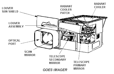
GOES GImager
The team validated its method against data collected from satellites that are part of the NOAA Geostationary Operational Environmental Satellite System (GOES).

However, the instruments aboard the satellites aren't capable of detecting particles much higher in energy than those associated with the peak radiation dose, according to Evenson.

"The instruments on the spacecraft are just too small to detect the faster, high-energy particles. They are set up to detect the particles that are most damaging," he explained.

Read more at the Antartic Sun

Wednesday, July 11, 2012

US Amundsen-Scott Station: Supermoon Lights Up South Pole

Soon after the 24-hour darkness of Antarctic winter descended on the United States' Amundsen-Scott Station at the South Pole, the crew of scientists and staff overwintering there got a much-welcomed dose of very bright moonlight.

In early May, a gleaming supermoon appeared — this full moon coincides with the moon's perigee, or closest monthly pass of the Earth.

Thanks to that quirk of timing, a supermoon appears larger and brighter than a typical full moon, and crews at the South Pole station took full advantage of the extra light, completing as much outside maintenance as possible.
"After weeks of walking and working in the dark, or perhaps guided by the faint red light of a headlamp, we could all of a sudden see what we were doing and where we were going," wrote South Pole correspondent Sven Lidstrom in the Antarctic Sun, a publication of the National Science Foundation (NSF).

In Antarctica, the sun sets for the austral winter sometime in April, and doesn't reappear until sometime in August, plunging the continent into utter darkness.

Although the newly built Amundsen Scott Station, a gleaming, elevated building opened fully in 2008, offers far more comforts than earlier South Pole stations, no human construction can fully make up for the unending night of the frigid winter months.

Crews at Australia's Davis Station, the southernmost of that nation's Antarctic research stations, also noted the arrival of the supermoon, and said the extra light made it easier to move about the compound.
"It is amazing how small things like actually seeing what you are doing can make your day," Lidstrom wrote.

Thursday, July 5, 2012

South Pole Station makes the most of liquid helium supply

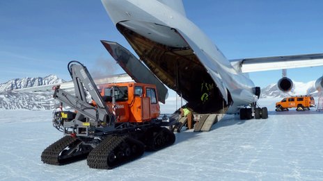
Image: A 4,000-gallon helium dewar is unloaded from an LC-130 at the South Pole Station. Such shipments may soon cease as experiments move away from using liquid helium to cool telescope sensors. 

Photo Credit: Paul Sullivan

Helium, it's not just good for party balloons.

At one of the coldest places on the planet -- where the temperature bolts down to minus 100 degrees Fahrenheit during the winter months -- liquid helium has been used to super-cool special telescopes designed to peer into the mysteries of the early universe.

However, the use of bulk liquid helium may also become a thing of the past, as the astrophysical experiments at the South Pole Station complete a conversion to a Cryocooler technology that cools telescope sensors to a temperature just above that of outer space by using and recapturing helium gas.

Helium is a limited resource that promises to become even scarcer and more expensive in the future. A bipartisan bill being considered in the U.S.

Senate this year would help conserve the nation's helium reserves -- locked up underground in a natural geological formation near Amarillo, Texas -- and give priority to federally funded researchers in times of shortage.

The South Pole Station has done its part over the last decade or so to stretch out the nation's helium supply, which is used in everything from the manufacture of fiber optics and microchips to cooling the superconducting magnets used in MRI machines.

The zero boil-off system now at the South Pole ensures that almost no helium is lost to the atmosphere.

Water, of course, has a boiling point of 100 degrees Celsius, transitioning from a liquid to a gas. Helium also has a boiling point, but a wee bit lower -- minus 269C.

On the Kelvin scale, that's about 4.2 degrees above absolute zero, the temperature at which all molecular motion stops. The temperature of outer space is about 3 Kelvin.

The telescopes at the South Pole do not operate in the visible light spectrum, but instead measure microwave radiation.

The telescope sensors use superconductive materials that must be cooled down to 250 milliKelvin, just a quarter of a degree above absolute zero, to study the cosmic microwave background, often described as an afterglow of the Big Bang when the universe burst into existence.

Liquid helium has been an integral part of cryogenic techniques since astrophysical experiments began at the South Pole in the 1980s, according to Paul Sullivan, South Pole Station manager of science support.

Read the full article: Full of cold air

Monday, March 19, 2012

Mysterious Green Swirls Spotted Off Antarctic Coast | Phytoplankton Blooms

These green swirls were spotted off the coast of East Antarctica on Feb. 27 by NASA's Terra satellite.

CREDIT: NASA image courtesy Jeff Schmaltz, LANCE/EOSDIS MODIS Rapid Response Team

Late last month, a NASA satellite flying over East Antarctica spotted swirls of green off the Princess Astrid Coast that left experts wondering just what it was.

Such a pattern usually indicates a bloom of tiny plantlike organisms called phytoplankton, which form the base of the ocean food chain.

Such blooms are common along the Antarctic coast, but typically form in early December, in the austral spring, not so late in the summer season, according to experts consulted by NASA.

"It doesn't look like a phytoplankton bloom to me," Stanford University marine biologist Kevin Arrigo, who led NASA's ICESCAPE expeditions to the Arctic in 2010 and 2011, told NASA. "The spatial pattern resembles the sea ice too closely. It looks suspiciously like green sea ice. Plus, it’s very late for such a bloom in the Antarctic."

Tuesday, March 6, 2012

NASA MODIS: Antarctic Algae Bloom Can be Seen from Space

A field of bright green algae in Antarctica could be seen from space.

Australian scientists spotted the algae captured in satellite pictures.

The scientists believe that the growth has been caused by a build-up of iron, most likely caused by snow that blew into the waters.

The algae bloom, which is about 200 kilometres wide and 100 kilometres long, was photographed from the Modis instrument on Nasa's Terra Satellite, at least 650 kms from the Earth.

Mark Curran from the Australian Antarctic Division reported that Antarctica's snow contained small amount of iron.

He said during summer, Amery Ice Shelf in East Antarctica had experienced strong winds which would have blown the snow into the ocean.

"Very, very tiny amounts of iron act as a nutrient," he said.

"Usually algae in this region are iron limited and so when they get a small amount of iron and they have everything else they need, that's enough for them to bloom," he added.

The scientists said that the algae had been there for more than three weeks and would not cause any damage to the environment.

They said it would disappear automatically.

Tuesday, February 7, 2012

Russians hit Water Driling for Antarctic lake


A radar satellite image shows smooth ice over the surface of Lake Vostok, over 3.5 kilometres down (Image: Canadian Space Agency/Radasat/NASA/Science Photo Library)

A Russian drilling team is trying to confirm that they have finally drilled into Lake Vostok, a vast subglacial lake hidden 3.5 kilometres beneath the surface of the Antarctic ice sheet.

A spokesperson for the Russian Antarctic Expedition in St Petersburg told New Scientist this morning that the drill made contact with water late last week and then automatically withdrew up the borehole, as planned.

That suggests the lake has been breached, but the team are now checking the level of water in the borehole and readings from pressure sensors to confirm that the water did come from the lake and not a pocket of water in the ice above the lake. 

Ice temperatures rise as you go deeper into the ice sheet, and approach melting point just above the lake, so the fact that the team hit liquid water doesn't necessarily mean they've reached the lake.

"For the time being we are waiting for official confirmation," said the spokesperson. An announcement is expected within the next two days.


Tuesday, January 24, 2012

Antartica (ANSMET): Hundreds of Meteorites Uncovered

A gang of heavily insulated scientists has wrapped up its Antarctic expedition, with its members thawing out from the experience, but pleased to have bagged more than 300 space rocks.

They are participants in the Antarctic Search for Meteorites program, or ANSMET for short. 

Since 1976, ANSMET researchers have been recovering thousands of meteorite specimens from the East Antarctic ice sheet. 

ANSMET is funded by the Office of Polar Programs of the National Science Foundation.

According to the ANSMET website, the specimens are currently the only reliable, continuous source of new, nonmicroscopic extraterrestrial material. 

Given that there are no active planetary sample-return missions coming or going at the moment, the retrieval of meteorites is the cheapest and only guaranteed way to recover new things from worlds beyond the Earth.

Friday, January 20, 2012

An iceberg floating in Neko Harbour, Antarctica

An underwater/above-water split picture of an iceberg floating in Neko Harbour in the Antarctic. 

Brazilian photographer, Daniel Botelho, captured not only the tip of the iceberg but the massive hunks of underwater ice as well.

Picture: Daniel Botelho / Barcroft USA

Monday, January 16, 2012

Antarctic lake drilling mission edges closer

An ambitious plan to explore a vast lake trapped beneath the Antarctic ice is a step closer to becoming reality.

An advance party has braved freezing temperatures to set up vital equipment and supplies at Lake Ellsworth.

The project by UK engineers to drill through the two-mile-thick ice-sheet is scheduled for the end of the year.

The aims are to search for signs of life in the waters and to extract sediments from the lake floor to better understand the past climate.

It is is one of the most challenging British scientific projects for years.

The task is so complex that preparations have had to be spread over two Antarctic summer seasons.

In the first phase a "tractor train" has just hauled nearly 70 tonnes of equipment from an ice runway at Union Glacier through the Ellsworth mountains to the lake site.

1. A hot water drill will melt through the frozen ice sheet, which is up to 3km (2 miles) thick. After drilling, they will have an estimated 24 hours to collect samples before the borehole re-freezes
2. A probe will be lowered through the borehole to capture water samples
3. A specialised corer will then recover sediment from the floor of the lake through the same borehole
Watch the team's animated explation of the planned drill.

Thursday, November 17, 2011

BAS Fly-through of Antarctica's Gamburtsev 'ghost mountains'

Click on the Image to visit BBC website and activate the Animation.

Scientists think they can now explain the existence of what are perhaps Earth's most extraordinary mountains.

The Gamburtsevs are the size of the European Alps and yet are totally buried beneath the Antarctic ice.

A geophysical survey of the range was conducted in 2008/9. This allowed researchers to assess the mountains' origin.

In this video, Fausto Ferraccioli from the British Antarctic Survey takes us on a virtual fly-through of the Gamburtsevs.

Animation courtesy of the British Antarctic Survey.

Sunday, August 21, 2011

NASA, ESA, JAXA Maps Antarctic Ice Flows

First complete map of the speed and direction of ice flow in Antarctica, derived from radar interferometric data from the Japan Aerospace Exploration Agency's ALOS PALSAR, the European Space Agency's Envisat ASAR and ERS-1/2, and the Canadian Space Agency's RADARSAT-2 spacecraft.

The colour-coded satellite data are overlaid on a mosaic of Antarctica created with data from NASA's Moderate Resolution Imaging Spectroradiometer (MODIS) instrument on NASA's Terra spacecraft.

Pixel spacing is 984 feet (300 meters). The thick black lines delineate major ice divides. Subglacial lakes in Antarctica's interior are also outlined in black. Thick black lines along the coast indicate ice sheet grounding lines.

Image credit: NASA/JPL-Caltech/UCI

Sunday, June 20, 2010

Friday, March 5, 2010

ESA ENVISAT: Animation of Antartica Mertz Glacier Breaking up


Click on the picture to run the animation

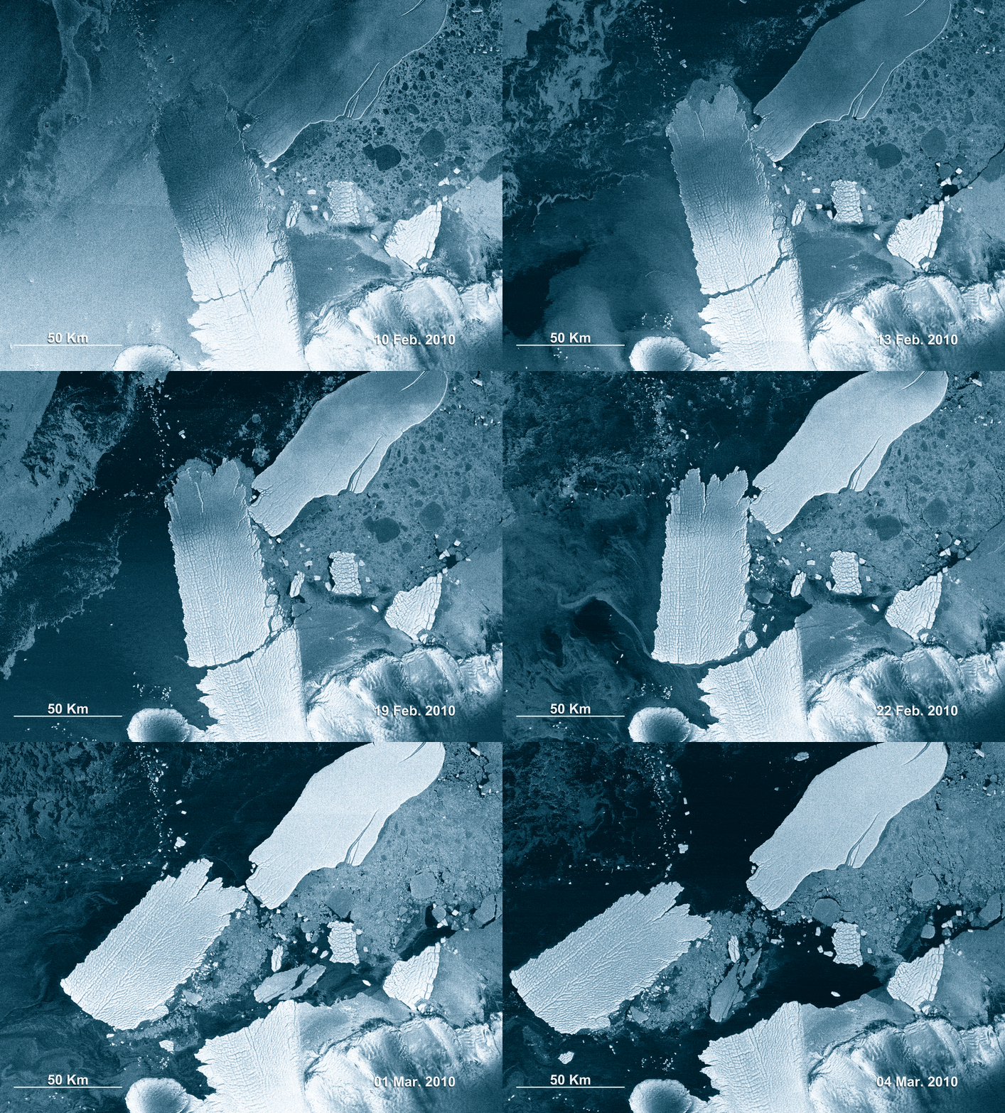
This animation, made up of eight Envisat radar images, shows the 97-km long B-9B iceberg (right) ramming into the Mertz Glacier Tongue in Eastern Antarctica in early February 2010.

The collision caused a chunk of the glacier’s tongue to snap off, giving birth to another iceberg nearly as large as B-9B. The new iceberg, named C-28, is roughly 78-km long and 39-km wide, with a surface area of 2500 sq km (the size of Luxembourg).

Envisat’s Advanced Synthetic Aperture Radar (ASAR) acquired these images from 10 February to 4 March in Wide Swath Mode, providing spatial resolution of 150 m. ASAR can pierce through clouds and local darkness and is capable of differentiating between different types of ice.

Credits: ESA

Friday, February 26, 2010

Mammoth iceberg could alter ocean circulation: study


Mammoth iceberg could alter ocean circulation: study

An iceberg the size of Luxembourg knocked loose from the Antarctic continent earlier this month could disrupt the ocean currents driving weather patterns around the globe, researchers said Thursday.

While the impact would not be felt for decades or longer, a slowdown in the production of colder, dense water could result in less temperate winters in the north Atlantic, they said.

The 2550 square-kilometre (985 square-mile) block broke off on February 12 or 13 from the Mertz Glacier Tongue, a 160-kilometer spit of floating ice protruding into the Southern Ocean from East Antarctica due south of Melbourne, researchers said.

Some 400 metres (1300 feet) thick, the iceberg could fill Sydney Harbour more than 100 times over.

It could also disturb the area's exceptionally rich biodiversity, including a major colony of emperor penguins near Dumont d'Urville, site of a French scientific station, according to the scientists.

"The ice tongue was almost broken already. It was hanging like a loose tooth," said Benoit Legresy, a French glaciologist who has been monitoring the Metz Glacier via satellite images and on the ground for a decade in cooperation with Australian scientists.

The billion-tonne mass was dislodged by another, older iceberg, known as B9B, which split off in 1987.

Jammed against the Antarctic continent for more than 20 years, B9B smashed into the Metz tongue like a slow-motion battering ram after it began to drift.

Both natural cycles and manmade climate change contribute to the collapse ice shelves and glaciers.

Tide and ocean currents constantly beat against exposed areas, while longer summers and rising temperatures also take a toll.

"Obviously when there is warmer water, these ice tongues will become more fragile," said Legresy, who works at the Laboratory for Geophysics and Oceanographic Space Research in Toulouse, southern France.

Monday, November 9, 2009

NASA: Greetings From Palmer Station, Antarctica

Residents of Palmer Station, Antarctica, used their bright red United States Antarctic Program parkas to send ground-to-air greeting to scientists and flight crew aboard NASA's DC-8 flying science laboratory as it flew over the station during Operation Ice Bridge.
Operation Ice Bridge is a study of Antarctic ice sheets, sea ice and glacial recession. One of three U.S. environmental research stations on the continent, Palmer Station is located on Anvers Island halfway down the Antarctic Peninsula.

Image Credit: NASA/John Arvesen