Showing posts with label fly-by. Show all posts

Friday, August 22, 2014

NASA VOYAGER 2 Fly-by of TRITON - Video


The Voyager 2 spacecraft flew by Triton, a moon of Neptune, on August 25, 1989. Paul Schenk, a scientist at the Lunar and Planetary Institute in Houston, used Voyager data to construct this video recreating that exciting encounter.

The Voyager mission is managed by NASA's Jet Propulsion Laboratory, in Pasadena, California, for NASA's Science Mission Directorate (SMD) at NASA Headquarters in Washington. Caltech manages JPL for NASA.

Image credit: NASA/JPL-Caltech/Lunar & Planetary Institute

Monday, December 30, 2013

Large Asteroid scheduled to Fly-by Earth


The space rock was discovered on Dec. 23rd, 2013 and will be makes its closest approach to Earth (3.6 lunar distance) on Jan. 3rd, 2014. Its is estimated to be 102 meters or 400 feet-wide.

Credit: NASA / JPL

Monday, December 9, 2013

ESA MARS Express: MARS North Pole Fly-by - Video


Data from the Mars Advanced Radar for Subsurface and Ionospheric Sounding instrument, MARSIS aboard ESA's Mars Express has been used to create this animation of the Red Planets north pole. The ice cap is about 1000km in diameter (621 miles).

Credit: ESA

Saturday, June 1, 2013

Asteroid 1998 QE2 Fly-by - Nasa YouTube video


As the 1.7-mile-long asteroid 1998 QE2 began its relatively close flyby of Earth, telescope images were provided during a live broadcast from the Jet Propulsion Laboratory, seen on NASA Television and nasa.gov.

Among the insight provided from asteroid experts at JPL and the Goldstone Deep Space Communications Complex, which used radar to track and image the asteroid -- a discovery that QE2 has an orbiting moon about 600 meters wide.

The program also featured NASA Administrator Charlie Bolden, who discussed the agency's role in keeping the planet safe from asteroids and other Near Earth Objects.

The May 31 QE2 fly-by -- some 3-point-6 million miles from Earth is asteroid's the closest approach to our planet for at least the next two centuries.

Also, Garver at Asteroid "Hang Out", MSL's RAD (iation) Measurements, Lightfoot visits Centers, Space Tech Town Hall, IceBridge completes 2013 mission, Grunsfeld visit to Ames and more!

Friday, May 31, 2013

Asteroid 1998 QE2 - Video


Asteroid 1998 QE2 is 1.7 miles in diameter, making it a very good skywatching subject. People with large backyard telescopes can point there telescopes to the skies from May 30th to June 4th to catch see the space rock tumble across the sky. Credit: NASA

Approaching Asteroid 1998 QE2 has a satellite Moon

First radar images of asteroid 1998 QE2 were obtained when the asteroid was about 3.75 million miles (6 million kilometers) from Earth.

CREDIT: NASA/JPL-Caltech/GSSR

A huge asteroid set to sail past Earth on Friday has its own moon, NASA scientists have just discovered.

Researchers obtained a series of radar images of the approaching asteroid 1998 QE2 late Wednesday (May 29) using the Deep Space Network antenna at Goldstone, Calif.

Images captured over the course of two hours showed that the asteroid is actually a binary system.

The main space rock is the size of nine ocean liners, roughly 1.7 miles (2.7 kilometers) across, and the satellite that orbits it is estimated to be 2,000 feet (600 meters) wide, according to NASA.

Binary systems are quite common among near-Earth asteroids. Of space rocks at least 655 feet (200 meters) across, about 16 percent are binary or triple systems, NASA officials said.

1998 QE2 poses no threat of hitting Earth during the flyby, space agency officials assure. Its closest approach will occur at 4:59 EDT on Friday (May 31) and it is expected to pass at least 3.6 million miles (5.8 million kilometers) away from the planet.

The asteroid won't be visible to the unaided eye as it zips by.

Though harmlessly far away, this will be the nearest 1998 QE2 gets to Earth in the next two centuries.

As it passes, the asteroid will be closely watched by astronomers. In addition to the 230-foot-wide (70 meter) Deep Space Network antenna, astronomers will also be using the Arecibo Observatory in Puerto Rico to observe 1998 QE2 until June 9.

Wednesday, September 5, 2012

NASA Cassini: Seasonal changes on Saturn

A blue hue appears in Saturn's southern hemisphere as winter approaches. Credit: NASA/JPL-Caltech/SSI

Three of the most recent images show Saturn’s largest moon, Titan, and the recently discovered vortex in the atmosphere at the south pole.

The visible light cameras on Cassini have been monitoring a strange yellow haze in the detached haze layer at Titan’s south pole since 27 March.

The visual and infrared spectrometers then detected clouds building up in the region on 22 May.

When Cassini flew by Titan on June 27, 2012, it was found that the vortex is spinning faster than the moon itself is rotating.

The views of the vortex are only possible because Cassini is on a new orbit that is tilted, which enables it to get a better look at the polar regions of both Saturn and its moons.

"Cassini has been in orbit now for the last eight years, and despite the fact that we can't know exactly what the next five years will show us, we can be certain that whatever it is will be wondrous," explains Carolyn Porco.

The south polar vortex is visible in this image. Credit: NASA/JPL-Caltech/SSI 

Cassini is currently in its second mission extension, which has been called the Solstice Mission, and monitoring the seasonal changes on the ringed planet is one of the main objectives at the moment.

"It is so fantastic to experience, through the instruments of Cassini, seasonal changes in the Saturn system," said depute project scientist Amanda Hendrix.

"Some of the changes we see in the data are completely unexpected, while some occur like clockwork on a seasonal timescale. It's an exciting time to be at Saturn."

Sunday, September 2, 2012

NASA Juno: Jupiter-Bound Probe Changes Orbit in Deep Space


Juno, NASA's Jupiter-bound probe fired its main engine Thursday (Aug. 30) to help set up a speed-boosting flyby of Earth next year.

The engine burn — which took place when the Juno spacecraft was about 300 million miles (483 million kilometers) from Earth — began at 6:57 p.m. EDT (2257 GMT) Thursday and lasted nearly 30 minutes.

It appears to have worked according to plan, changing the probe's velocity by about 770 mph (1,240 kph), researchers said.

"This first and successful main engine burn is the payoff for a lot of hard work and planning by the operations team," Juno project manager Rick Nybakken, of NASA's Jet Propulsion Laboratory in Pasadena, Calif., said in a statement.

"We started detailed preparations for this maneuver earlier this year, and over the last five months we've been characterizing and configuring the spacecraft, primarily in the propulsion and thermal systems," he added.

After another burn this Tuesday (Sept. 4), Juno should be on course for its Earth flyby on Oct. 9, 2013, which will bring the probe within 310 miles (500 km) of our planet. Earth's gravity will give the spacecraft a big push, boosting its velocity by 16,330 mph (26,280 kph) and placing Juno on its final path to Jupiter, researchers said. Juno was launched on Aug. 5, 2011 and is slated to arrive at the solar system's largest planet on July 4, 2016. Once there, Juno will orbit Jupiter 33 times from pole to pole, using its eight science instruments to peer beneath the gas giant's thick clouds. (The spacecraft takes its name from the goddess Juno, who was able to see through the clouds devised by her husband Jupiter in an attempt to hide his mischief.) The main goal of the $1.1 billion mission is to learn about Jupiter's atmosphere, magnetosphere, composition and origins, and to determine if the planet has a solid core, researchers said.

Wednesday, July 11, 2012

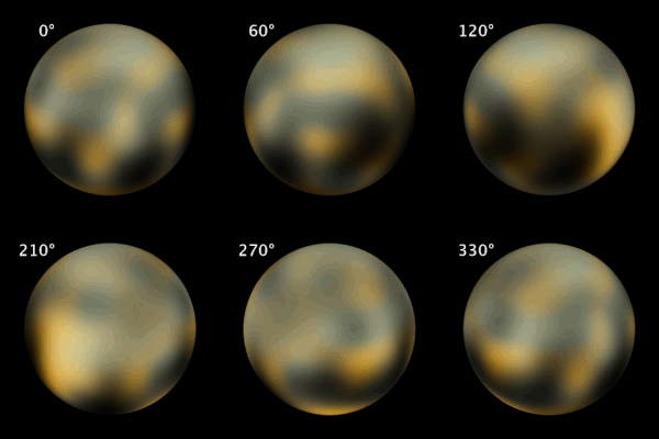
ESA NASA CSA Hubble spots new moon around Pluto


Pluto’s new-found moon, visible as a speck of light in Hubble images, is estimated to be irregular in shape and between 10 and 25 kilometres across.

The moons form a series of neatly nested orbits, a bit like Russian dolls,” said Mark Showalter of the SETI Institute in Mountain View, USA, leader of the scientific team that


The Pluto team is intrigued that such a small planet can have such a complex collection of satellites. The new discovery provides additional clues for unraveling how the Pluto system formed and evolved.

The favoured theory is that all the moons are relics of a collision between Pluto and another large Kuiper belt object billions of years ago.

Pluto animiert.gifPluto’s largest moon, Charon, was discovered in 1978. Hubble observations in 2006 uncovered two additional small moons, Nix and Hydra. In 2011 another moon, known as P4, was found in Hubble data.

Provisionally designated S/2012 (134340) 1, or P5, the latest moon was detected in nine separate sets of images taken by Hubble’s Wide Field Camera 3 on 26, 27 and 29 June, and 7 and 9 July 2012.

New Horizons, a NASA space probe, is currently en route to Pluto, with a high-speed flyby scheduled for 2015.

It will return the first ever detailed images of the Pluto system, which is so small and distant that even Hubble can barely see the largest features on its surface.

In the years following the New Horizons Pluto flyby, astronomers plan to use the infrared vision of Hubble’s planned successor, the NASA/ESA/CSA James Webb Space Telescope, for follow-up observations.

The James Webb Space Telescope will be able to study the surface chemistry of Pluto, its moons, and many other bodies that lie in the distant Kuiper Belt along with Pluto

Friday, April 27, 2012

NASA Space Shuttle Enterprise: Fly-by in Manhattan

The Space Shuttle Enterprise flies over the Hudson River in Manhattan

Monday, March 19, 2012

NASA Cassini Spies Wave Rattling Jet Stream on Jupiter

Following the path of one of Jupiter's jet streams, a line of v-shaped chevrons travels west to east just above Jupiter's Great Red Spot.

Most of the planet is unfolded here in a single flat map made on December 11 and 12, 2000, when NASA's Cassini spacecraft flew past Jupiter.

At the left, the chevrons run into another storm called the South Equatorial Disturbance (SED). Image credit: NASA/JPL/Space Science Institute

New movies of Jupiter are the first to catch an invisible wave shaking up one of the giant planet's jet streams, an interaction that also takes place in Earth's atmosphere and influences the weather.

The movies, made from images taken by NASA's Cassini spacecraft when it flew by Jupiter in 2000, are part of an in-depth study conducted by a team of scientists and amateur astronomers led by Amy Simon-Miller at NASA's Goddard Space Flight Center in Greenbelt, Md., and published in the April 2012 issue of Icarus.

"This is the first time anyone has actually seen direct wave motion in one of Jupiter's jet streams," says Simon-Miller, the paper's lead author. "And by comparing this type of interaction in Earth's atmosphere to what happens on a planet as radically different as Jupiter, we can learn a lot about both planets."

Like Earth, Jupiter has several fast-moving jet streams that circle the globe. Earth's strongest and best known jet streams are those near the North and South Poles; as these winds blow west to east, they take the scenic route, wandering north and south.

What sets these jet streams on their meandering paths-and sometimes makes them blast Florida and other warm places with frigid air-are their encounters with slow-moving waves in Earth's atmosphere, called Rossby waves.

In contrast, Jupiter's jet streams "have always appeared to be straight and narrow," says co-author John Rogers, who is the Jupiter Section Director of the British Astronomical Association, London, U.K., and one of the amateur astronomers involved in this study.

Rossby waves were identified on Jupiter about 20 years ago, in the northern hemisphere. Even so, the expected meandering winds could not be traced directly, and no evidence of them had been found in the southern hemisphere, which puzzled planetary scientists.

To get a more complete view, the team analyzed images taken by NASA's Voyager spacecraft, NASA's Hubble Space Telescope, and Cassini, as well as a decade's worth of observations made by amateur astronomers and compiled by the JUPOS project.

The movies zoom in on a single jet stream in Jupiter's southern hemisphere. A line of small, dark, v-shaped "chevrons" has formed along one edge of the jet stream and zips along west to east with the wind.

Later, the well-ordered line starts to ripple, with each chevron moving up and down (north and south) in turn. And for the first time, it's clear that Jupiter's jet streams, like Earth's, wander off course.

"That's the signature of the Rossby wave," says David Choi, the postdoctoral fellow at NASA Goddard who strung together about a hundred Cassini images to make each time-lapse movie. "The chevrons in the fast-moving jet stream interact with the slower-moving Rossby wave, and that's when we see the chevrons oscillate."

The team's analysis also reveals that the chevrons are tied to a different type of wave in Jupiter's atmosphere, called a gravity inertia wave. Earth also has gravity inertia waves, and under proper conditions, these can be seen in repeating cloud patterns.

Thursday, February 16, 2012

NASA Cassini: Rhea Before Titan

Craters appear well defined on icy Rhea in front of the hazy orb of the much larger moon Titan in this Cassini spacecraft view of these two Saturn moons.

Lit terrain seen here is on the leading hemispheres of Rhea and Titan. 

North on the moons is up and rotated 13 degrees to the left. 

The limb, or edge of the visible disk, of Rhea is slightly overexposed in this view.

The image was taken in visible green light with the Cassini spacecraft narrow-angle camera on Dec. 10, 2011. 

The view was acquired at a distance of approximately 1.2 million miles (2 million kilometers) from Titan and at a Sun-Titan-spacecraft, or phase, angle of 109 degrees.

The view was acquired at a distance of approximately 810,000 miles (1.3 million kilometers) from Rhea and at a Sun-Rhea-spacecraft, or phase, angle of 109 degrees. Image scale is 8 miles (12 kilometers) per pixel on Titan and 5 miles (8 kilometers) per pixel on Rhea.

Image credit: NASA/JPL-Caltech/Space Science Institute

Tuesday, January 24, 2012

NASA Cassini Image: Saturn's Moons Mimas And Dione

Saturn's moon Mimas peeks out from behind the night side of the larger moon Dione in this Cassini image captured during the spacecraft's Dec. 12, 2011, flyby of Dione.

Dione is 698 miles, or 1,123 kilometers, across and its day side dominates the view on the right of the image. Smaller Mimas is on the left and measures 246 miles, or 396 kilometers, across.

Lit terrain seen here is on the Saturn-facing side of Mimas and in the area between the trailing hemisphere and anti-Saturn side of Dione. North on the moons is up and rotated 20 degrees to the right.

The image was taken in visible light with the Cassini spacecraft narrow-angle camera.

The view was obtained at a distance of approximately 58,000 miles (94,000 kilometers) from Dione and at a Sun-Dione-spacecraft, or phase, angle of 42 degrees. Image scale is 1,833 feet (559 meters) per pixel on Dione.

The view was obtained at a distance of approximately 380,000 miles (611,000 kilometers) from Mimas and at a Sun-Mimas-spacecraft, or phase, angle of 41 degrees. Image scale is 2 miles (3 kilometers) per pixel on Mimas.

Monday, January 23, 2012

ESA Cassini: The two faces of Saturn moon Titan's dunes

Two different dune fields on Titan: Belet and Fensal, as imaged by Cassini’s radar. It also shows two similar dune fields on Earth in Rub Al Khali, Saudi Arabia. 

Fensal is at higher latitude and elevation than Belet and clearly shows thinner dunes with brighter and wider areas in between, suggesting less abundant dune material in this region.

Credits: NASA/JPL–Caltech/ASI/ESA and USGS/ESA

A new analysis of radar data from the international Cassini spacecraft has revealed regional variations amongst Titan's sand dunes. The result yields new clues to the giant moon's climatic and geological history.

Dune fields are common on Titan, the largest moon of Saturn, second only to the seemingly uniform plains that cover most of the surface.

They cover about 13% of Titan, stretching over 10 million sq km, roughly equivalent to the area of Canada. Thus they offer a large-scale insight into the moon's environment.

Though similar in shape to the linear sand dunes found in the deserts of Namibia or southern Arabia, Titan's dunes are gigantic by Earthly standards. They are on average 1–2 km wide, hundreds of kilometres long and around 100 m high.

However, their size and spacing vary across the surface, betraying the environment in which they have formed and evolved.

Another difference is that sand on Titan is not made of silicates as on Earth, but of solid hydrocarbons that precipitate out of the atmosphere. These then aggregate into millimetre-sized grains by a still unknown process.

Using radar data from the NASA–ESA–ASI Cassini spacecraft, Alice Le Gall, of LATMOS-UVSQ, Paris and NASA–JPL, California, and collaborators have discovered that the size of Titan's dunes is controlled by at least two factors: altitude and latitude.

The main dune fields on Titan are found in lowland areas. Dunes at higher elevations tend to be narrower and more widely separated, and the gaps between them appear brighter to Cassini's radar, indicating a thinner covering of sand.

This suggests that there is relatively little sand available at higher elevations to build dunes, while more is present in the lowlands.

In terms of latitude, the dunes on Titan are confined to its equatorial region, in a band between 30°S and 30°N.

However, they tend to become narrower and more widely spaced at northern latitudes. Dr Le Gall and colleagues think that this may be due to Saturn's elliptical orbit.

Titan orbits Saturn and so the moon's seasons are controlled by Saturn's path around the Sun. Because Saturn takes about 30 years to complete an orbit, each season on Titan lasts for just over seven years.

The slightly elliptical nature of Saturn's orbit means that the southern hemisphere of the moon has shorter but more intense summers.

As a result, in southern regions, surface wetness due to ethane and methane vapour in the soil is reduced.

The drier the sand grains, the more easily they can be transported by the winds to make dunes.

"As one goes to the north, the soil moisture probably increases, making the sand particles less mobile and, as a consequence, the development of dunes more difficult," says Dr Le Gall.

Friday, January 20, 2012

NASA Saturn Cassini: Closest Dione Flyby

Flying past Saturn's moon Dione, Cassini captured this view which includes two smaller moons, Epimetheus and Prometheus, near the planet's rings.

The image was taken in visible light with Cassini's narrow-angle camera during the spacecraft's flyby of Dione on Dec. 12, 2011.

This encounter was the spacecraft's closest pass of the moon's surface, but, because this flyby was intended primarily for other Cassini instruments, it did not yield Cassini's best images of the moon. Higher resolution images were obtained during earlier flybys (see PIA07638).

Dione (698 miles, or 1,123 kilometers across) is closest to Cassini here and is on the left of the image.

Potato-shaped Prometheus (53 miles, or 86 kilometers across) appears above the rings near the center top of the image. Epimetheus (70 miles, or 113 kilometers across) is on the right.

This view looks toward the northern, sunlit side of the rings from less than one degree above the ring plane.

The view was acquired at a distance of approximately 67,000 miles (108,000 kilometers) from Dione. Image scale is 2,122 feet (647 meters) per pixel on Dione.

Image credit: NASA/JPL-Caltech/Space Science Institute

Saturday, January 7, 2012

Fly Around International Space Station - YouTube


This fly around of the International Space Station (ISS) is displayed in the "Moving Beyond Earth" exhibition at the National Air and Space Museum on the National Mall in Washington, DC. Displayed as a 30ft x 18ft projection, the HD animation highlights the major components of the ISS.

Video courtesy of NASA's VR Lab.

Wednesday, December 14, 2011

NASA Cassini Fly-by - Saturn's moon Dione

NASA's Cassini spacecraft obtained this unprocessed image on Dec. 12, 2011.

The camera was pointing toward Saturn's moon Dione from approximately 69,989 miles (112,636 kilometers) away.
The camera was pointing toward Saturn's moon Dione from approximately 76,344 miles (122,864 kilometers) away.

Images credit: NASA/JPL/Space Science Institute

 
NASA's Cassini spacecraft successfully completed its closest-ever pass over Saturn's moon Dione on Monday, Dec. 12, slaloming its way through the Saturn system on its way to tomorrow's close flyby of Titan.

Cassini is expected to glide about 2,200 miles (3,600 kilometers) over the Titan surface on Dec. 13.

In the selection of the raw images obtained during the Cassini Dione flyby, Dione is sometimes joined by other moons. Mimas appears just beyond the dark side of Dione in one view.

In another view, Epimetheus and Pandora appear together, along with Saturn's rings.

This Dione encounter was intended primarily for Cassini's composite infrared spectrometer and radio science subsystem.

However, the imaging team did capture views of the distinctive, wispy fractures on the side of Dione that always trails in its orbit around Saturn.

It also obtained images of a ridge called Janiculum Dorsa on the hemisphere of Dione that always leads in its orbit around Saturn.

While other flybys produced more detailed views of the surface, the best resolved images from this flyby have scales ranging from about 1,100 feet (350 meters) to about 1,600 feet (500 meters) per pixel.

Janiculum Dorsa will be imaged by Cassini at higher resolution in May 2012

Friday, November 18, 2011

Pluto's Hidden Ocean - New Horizons

An artist's concept of the New Horizons spacecraft as it visits Pluto in 2015.

Instruments will map Pluto and its moon, Charon, providing detail not only on the surface of the dwarf planet, but also about its shape, which could reveal whether or not an ocean lies beneath the ice. 

Credit: NASA/Johns Hopkins University Applied Physics Laboratory/Southwest Research Institute.

When NASA's New Horizons cruises by Pluto in 2015, the images it captures could help astronomers determine if an ocean is hiding under the frigid surface, opening the door to new possibilities for liquid water to exist on other bodies in the solar system.

New research has not only concluded such an ocean is likely, but also has highlighted features the spacecraft could identify that could help confirm an ocean's existence.

Pluto's outer surface is composed of a thin shell of nitrogen ice, covering a shell of water ice.

Planetary scientists Guillaume Robuchon and Francis Nimmo, both of the University of California at Santa Cruz, wanted to find out whether or not an ocean could exist underneath this icy shell, and what visible signs such an ocean might produce on the surface.

The pair modeled the thermal evolution of the dwarf planet and studied the behavior of the shell to see how the surface would be affected by the presence of an ocean below.

Searching the surface
Ironically, the easiest feature to identify would appear if no ocean existed. As spherical bodies spin, their angular momentum tends to push material towards the equator, forming a bulge.

If Pluto boasts a liquid layer, the ice would flow, reducing such a protrusion. Thus, the appearance of a "frozen-in"primordial bulge, left over from when Pluto spun more rapidly, would signify a lack of ocean.

"If the bulge is present, it will be about 6 miles (10 km) high, so it should be readily detectable," Nimmo said. New Horizons project scientist Hal Weaver agreed on the last point.

"New Horizon imaging will measure the shape of Pluto very accurately."

Monday, June 20, 2011

NASA - Cassini Captures Ice Queen Helene

NASA's Cassini spacecraft successfully completed its second-closest encounter with Saturn's icy moon Helene on June 18, 2011, beaming down raw images of the small moon.

At closest approach, Cassini flew within 4,330 miles (6,968 kilometers) of Helene's surface.

It was the second closest approach to Helene of the entire mission.

Image credit: NASA/JPL-Caltech/Space Science Institute

Monday, March 15, 2010

ESA Mars Express: Phobos Fly-by Images Released

Images from the recent flyby of Phobos, on 7 March 2010, are released today. See them here on the ESA Mars Blog.

The images show Mars' rocky moon in exquisite detail, with a resolution of just 4.4 metres per pixel.

They show the proposed landing sites for the forthcoming Phobos-Grunt mission.

ESA's Mars Express spacecraft orbits the Red Planet in a highly elliptical, polar orbit that brings it close to Phobos every five months.

It is the only spacecraft currently in orbit around Mars whose orbit reaches far enough from the planet to provide a close-up view of Phobos.

Like our Moon, Phobos always shows the same side to the planet, so it is only by flying outside the orbit that it becomes possible to observe the far side. Mars Express did just this on 7, 10 and 13 March 2010. Mars Express also collected data with other instruments.

Phobos is an irregular body measuring some 27 × 22 × 19 km. Its origin is debated. It appears to share many surface characteristics with the class of 'carbonaceous C-type' asteroids, which suggests it might have been captured from this population.

However, it is difficult to explain either the capture mechanism or the subsequent evolution of the orbit into the equatorial plane of Mars. An alternative hypothesis is that it formed around Mars, and is therefore a remnant from the planetary formation period.