Showing posts with label UAV. Show all posts

Friday, October 17, 2014

Boeing X37B, US Top Secret Spy Plane lands after 674 days in Orbit

This June 16, 2012 file image from video made available by the Vandenberg Air Force Base shows an infrared view of the Boeing X-37B unmanned spacecraft landing at Vandenberg Air Force Base. 

The purpose of the U.S. military's space plane is classified, only fueling speculation about why it has been orbiting Earth for nearly two years on this, its third mission. 

The plane is expected to land this week at a Southern California Air Force base. 

Credit: AP Photo /Vandenberg Air Force Base

A top-secret space plane landed Friday at an Air Force base on the Southern California coast.

The plane spent nearly two years circling Earth on a classified mission. Known as the Boeing X-37B, it resembles a mini space shuttle.

It safely touched down at 9:24 a.m. Friday, officials at Vandenberg Air Force Base said.

Just what the plane was doing during its 674 days in orbit has been the subject of sometimes spectacular speculation.

Several experts have theorized it carried a payload of spy gear in its cargo bay.

Other theories sound straight out of a James Bond film, including that the spacecraft would be able to capture the satellites of other nations or shadow China's space lab.

In a written release announcing the return of the craft, the Air Force only said it had been conducting "on-orbit experiments."

The Boeing X-37B program has been an orphan of sorts, bouncing since its inception in 1999 between several federal agencies, NASA among them. It now resides under the Air Force's Rapid Capabilities Office.

The plane that landed Friday is one of two built by Boeing. This is the program's third mission, and began in December 2012.

The plane stands 9 1/2 feet tall and is just over 29 feet long, with a wingspan under 15 feet. It weighs 11,000 pounds and has solar panels that unfurl to charge its batteries once in orbit.

The Air Force said it plans to launch the fourth Boeing X-37B mission from Cape Canaveral, Florida, next year.

Thursday, October 9, 2014

SHERPA: A Life Saving UAV Quadcopter Project in the Alps


Scientists at the University of Twente are working on robots that are expected to save lives in calamity situations in the Alps.

The emphasis within this SHERPA project is on cooperation between human rescue workers, the ground robot ('ground rover') with a robotic arm and flying robots.

This week all the members of the SHERPA consortium will meet in Twente in order to harmonize their results and to experiment with the various parts of the robot platform.

It is because of scientific innovations that robots are increasingly being relocated from predictable environments such as factories, to locations where calamities can occur, such as the Alps.

The robots of the SHERPA project provide rescue workers with support during their tasks, for instance, after an avalanche.

In extreme, dangerous cases, these robots can even take over some aspects of the work of their human team-members by locating victims. SHERPA will greatly increase the chance of saving victims.

Humans and robots working together
What is unique about SHERPA is the cooperation between humans and robots, each with their own qualities, in order to achieve a common goal: saving lives.

The emphasis with robots is on their autonomy, cognitive capacities, strategy for cooperation and in the interaction with their human colleagues.'

Together, humans and robots will form rescue teams that the Italian organization of rescue workers has stationed in the Alps.

On behalf of the University of Twente (UT), Raffaella Carloni and other members of the Robotics and Mechatronics group (CTIT institute) and the LEO Centre for Service Robotics are working on the mechanical design, the control mechanism and realizing the robotic arm.

This arm is being developed and constructed in Twente and will be mounted onto the ground robot.

Furthermore, the UT is focussing on technological support of the interaction between humans and robots.

The robotic arm is capable of grasping the Unmanned Aerial Vehicle (UAV), i.e., the flying robot, while it is airborne and placing it on the charger for the ground robot.

This innovative robotic arm is unique because it rigidity can be adjusted to a task. In addition, the arm is more resilient to shocks and vibrations than the current generation of robotic arms.

To provide a rescue worker who is operating the airborne robot with the best possible technological support, he or she will be equipped with sensors and portable technology. This too is, in part, a 'task of ' the UT.

The enormous advantage of this approach is that a rescue worker has optimum perception and can respond adequately to a possible calamity situation without actually having to be present at the site of the calamity.

The Sensors measure the robot's dynamic movements, such as position, speed and resistance. Because of the robot's cognitive algorithms, the robot and human can jointly seek victims and determine their actions in order to save human lives.

Sunday, September 28, 2014

Quarkson: SkyOrbiter UAV fleet to provide Web Access in remote areas

Web access can transform regions in terms of education, communication and health, during emergency situations, a working Internet signal can be the difference between life and death.

Facebook has already aired a plan to use unmanned drones to get remote areas of the world connected, and Portuguese company Quarkson wants to follow suit with its own SkyOrbiter fleet of unmanned aerial vehicles (UAVs).

The SkyOrbiters bridge the gap between satellites orbiting in space and users on the ground, Internet access is provided not by cell towers fixed to underground networks, but by the drones in the air, beaming out high-speed data connections for the population down below to take advantage of.

For remote, rural, undeveloped areas this is a more efficient and cost-effective way of getting people connected.

In some areas, depending on the specific requirements, the SkyOrbiter may connect with a substation at ground level (directly hooked into the Web) rather than a satellite up in space.

4G data speeds can be provided to any area with a line of sight to one of these Quarkson SkyOrbiter drones.

There are a total of nine different SkyOrbiter drones in the pipeline, which operate at either a high or low altitude, 22,000m (72,180ft) or 3,500m (11,480ft) respectively.

The most basic, the LA25, can stay in the air for two weeks and 42,714km (26,540 miles); the most advanced, the HA75, will be able to stay airborne for five years and an incredible 5,000,000km (3,107,000 miles).

That's because the higher altitude planes are powered by solar energy, so they can keep going as long as the sun is shining, with a network of these always-on UAVs circling around the skies above, parts of the planet that were previously cut off can be connected very quickly.

According to the United Nations, Internet access is a human right, and ensuring universal access to it should be a priority for all countries.'

The size and payload of the UAVs in Quarkson's fleet varies significantly.

The LA25 has a wingspan of around 25 metres (82 feet) and a maximum payload of 35kg (77lbs).

This increases with each model until you get to the HA75, with a wingspan of 75 metres (246 feet) and a maximum payload of 280kg (617lbs).

If you haven't twigged, the codename for each drone indicates the altitude it can reach and its wingspan.

It's not just about Internet connectivity, either: the UAV fleet can be used to capture aerial imagery, monitor environmental conditions, track down illegal operations and more besides.

Each drone is controlled by a Constellation Manager unit on the ground.

Wednesday, September 24, 2014

DHL Paketkopter 2.0: Juist Island to get first German drone delivery service

Deutsche Post DHL says it is starting Germany's first drone package delivery service, a test program transporting medicine to a pharmacy on a North Sea island.

The company said the quad-rotor "DHL Paketkopter 2.0" will begin daily flights Friday, bringing a maximum load of 1.2 kilograms (2.65 pounds) of medicine to the German island of Juist.

The island has about 1,500 inhabitants. It's usually served by one ferry per day and an occasional small-aircraft flight, depending on the weather.

DHL said Wednesday it will monitor each 12-kilometer (7.5-mile) flight to the island, but the water, snow and dust-resistant drone will fly on autopilot to deliver the medicine—at no extra cost during the test.

The company says it currently has no concrete plans for full-scale regular drone deliveries.

Together with the two research and development partners, the Institute of Flight System Dynamics, RWTH Aachen and the Microdrones GmbH, went through DHL package one led by the Lower Saxony Ministry for Economic Affairs, Labour and Transport of review and approval process.

The Federal Ministry of Transport and digital infrastructure has set up in coordination with the German Air Traffic Control (DFS) for this research project an exclusive restricted area.

In addition to the island of Juist municipality and the town of Norden, the National Park Administration Wadden Sea has approved the use of the copter.

Thursday, May 29, 2014

Flocking Drones UAV: Nature inspires future developments - Video

Biologically-inspired flapping-wing robots are shown. 

Image courtesy Pakpong Chirarattananon.

Researchers have been taking tips from nature to build the next generation of flying robots.

Based on the mechanisms adopted by birds, bats, insects and snakes, 14 distinguished research teams have developed solutions to some of the common problems that drones could be faced with when navigating through an urban environment and performing novel tasks for the benefit of society.

Whether this is avoiding obstacles, picking up and delivering items or improving the take-off and landing on tricky surfaces, it is hoped the solutions can lead to the deployment of drones in complex urban environments in a number of different ways, from military surveillance and search and rescue efforts to flying camera phones and reliable courier services. For this, drones need exquisite flight control.

The research teams have presented their work, 23 May, in a special issue of IOP Publishing's journal Bioinspiration and Biomimetics, devoted to bio-inspired flight control.

The first small drones have already been used in search and rescue operations to investigate difficult-to-reach and hazardous areas, such as in Fukushima, Japan.

A video by the COLLMOT Robotic Research Project showing a group of drones flying autonomously across a field.

A research team from Hungary believe these efforts could be improved if robots are able to work in tandem, and have developed an algorithm that allows a number of drones to fly together like a flock of birds.

The effectiveness of the algorithm was demonstrated by using it to direct the movements of a flock of nine individual quadcopters whilst they followed a moving car.

While this collective movement may be helpful when searching vast expanses of land, a group of researchers from Harvard University have developed a millimetre-sized drone with a view to using it to explore extremely cramped and tight spaces.

The microrobot they designed, which was the size of a one cent coin, could take off and land and hover in the air for sustained periods of time.

In their new paper, the researchers have demonstrated the first simple, fly-like manoeuvres. In the future, millimetre-sized drones could also be used in assisted agriculture pollination and reconnaissance, and could aid future studies of insect flight.

Once deployed into the real world, drones will be faced with the extremely tricky task of dealing with the elements, which could be extreme heat, the freezing cold, torrential rain or thunderstorms.

The most challenging problem for airborne robots will be strong winds and whirlwinds, which a research team, from the University of North Caroline at Chapel Hill, University of California and The Johns Hopkins University, have begun to tackle by studying the hawk moth.

In their study, the researchers flew hawk moths through a number of different whirlwind conditions in a vortex chamber, carefully examining the mechanisms that the hawk moths used to successfully regain flight control.

The whole collection of related papers can be downloaded for free from http://iopscience.iop.org/1748-3190/9/2

Tuesday, May 27, 2014

NOAA Hurricane Research Storm Drones

In this April 29, 2014 photo, Joe Cione, who studies how storms interact with the ocean at the (National Oceanic and Atmospheric Administration) NOAA's Hurricane Research Division in Miami, displays a drone he hopes to use this hurricane season for research. 

NOAA researchers plan to test five or six drones in the peak of hurricane season that will be transmitting data that could help forecasters understand what makes some storms fizzle while others strengthen into monsters. AP Photo/J Pat Carter

The point where the roiling ocean meets the fury of a hurricane's winds may hold the key to improving storm intensity forecasts, but it's nearly impossible for scientists to see.

That may change this summer, thanks to post-Hurricane Sandy federal funding and a handful of winged drones that can spend hours spiraling in a hurricane's dark places.

The drones will be transmitting data that could help forecasters understand what makes some storms fizzle while others strengthen into monsters.

Researchers at the NOAA's plan to test five or six drones in the peak of hurricane season.

The $1.25 million project is among a slew of other NOAA hurricane research funded by last year's Sandy supplemental bill that authorised $60 billion for disaster relief agencies.

Wednesday, March 12, 2014

ARCA: Air Strato Electric UAV completes rough landing tests


On February 13, 2014, Air Strato, electrical powered unmanned aerial vehicle performed the first take-off from rough, frozen ground.

The aircraft performed a short flight at 25 m altitude and then landed.

Air Strato was powered by four electrical engines. Two supplementary electric motors (engines) were added to boost power and shorten the take-off distance.

Additional suspension strengthening was installed on the wings and forward landing gear.

Despite this addition, the right landing gear suspension sustained some damage at touch down.

"The aircraft had only 10 percent of the batteries intended for the commercial version so we had to add ballast to simulate take-off weight."

"We also added two more electrical motors to increase thrust, needed on the rough ground to decrease take-off distance that, combined with the landing gear suspension, provided for a smooth taxi and take-off on rough terrain."

"It took less than 30 m to lift into the air at maximum thrust. Also we were impressed by the aircraft's rate of climb." - Teodor Diaconu, ARCA flight dynamics engineer.

Air Strato is a high altitude electrical powered unmanned aerial vehicle (UAV). It can reach altitudes of above 18 km and has an autonomy of 7 hours on internal batteries and 3 days using solar panels.

It can carry a variable payload up to 30 kg consisting of surveillance equipment or other scientific instruments.

Wednesday, March 5, 2014

Oppressive China Unveils Smog-Busting Drone in Fight Against Pollution

A tourist boat, decorated with green lights, travels on the Pearl River amid heavy haze in Guangzhou, Guangdong province, China

Credit: Reuters 

China is preparing to test a smog-busting drone in an effort to help clean up air pollution, which has reached crisis levels in most big cities across the country.

Pollution experts will test a parafoil plane made by the Aviation Industry Corporation of China.

The unmanned vehicle has a gliding parachute which contains chemicals that effectively mop up particulates and other pollutants in the air.

The drone has flexible wings, making it easier to control. It can also carry three times the amount of chemical cargo than similar-sized aircraft, the company's chief executive, Ma Yongsheng, said.

A parafoil drone designed by the state-owned Aviation Industry Corporation of China conducts "fog-clearing" operations in Ningbo. 

The firm says testing of a type of smog-fighting drone will begin soon. 

Photo: Nandu.com

According to the South China Morning Post, Ma said the parachute can carry up to 700kg of smog clearing-chemicals.

Over recent years, Chinese authorities have used planes to spray chemicals into the air, causing pollutants in smog to fall to the ground.

Ma also noted the drone can be used for emergency rescue, disaster relief and surveillance. There is also potential for its use in agriculture as it can spread seeds over wide areas.

Premier Li Keqiang told the National People's Congress rubberstamp parliament in Beijing that he had authorised a "war on pollution".

Five facts about China's smog

  • 600 million people in China have been affected by the smog blanketing large parts of the country.
  • The number of people admitted to hospital in Beijing for smog-related illnesses rose by 20% in 2013. Cases of breathing-related problems rose by 50%.
  • Many foreign workers have left China because of health fears caused by the smog. One company reportedly pays expats around £15,000 a year extra to work in China as part of a hardship allowance.
  • The Chinese have spent £85m on anti-smog products, such as masks and air purifiers.
  • It's not all bad news. The Chinese news agency claims smog "unifies the Chinese people". It says smog makes them more conscious of their health and "more willing to show love to each other".


Sunday, December 8, 2013

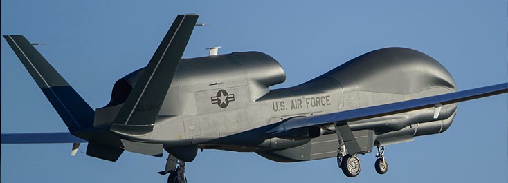
Northrop Grumman AF-18 UAS: Block 40 Global Hawk HALE, starts into production

The latest version of the RQ-4 Global Hawk high-altitude, long-endurance (HALE) unmanned aircraft system (UAS) took off from Northrop Grumman’s manufacturing plant in Palmdale, California, and flew to nearby Edwards Air Force Base on November 16.

Designated AF-18, the aircraft is a ‘Block 40’ version and the eleventh Global Hawk to arrive at Edwards.

Global Hawk production acceptance activities will now move from Edwards to ‘Air Force Plant 42’ in Palmdale, speeding up deliveries.

"AF-18 is the first of 15 Block 40 Global Hawk aircraft scheduled for fielding to Grand Forks Air Force Base, North Dakota, in 2010," said Steve Amburgey, Global Hawk programme director for the 303d Aeronautical Systems Group based at Wright-Patterson Air Force Base in Ohio.

The Block 40 aircraft feature ‘Multi-Platform - Radar Technology Insertion Program radar' (MP-RTIP), a "modular, active electronically scanned array radar system", primary improvements being an increase in resolution and an ability "to collect ground moving target indicator imagery and synthetic aperture radar still images simultaneously", according to manufacturer Raytheon.

The MP-RTIP radar uses active electronically scanned array (AESA) technology and commercial off-the-shelf hardware to deliver long range, very high-resolution synthetic aperture radar (SAR), ground moving target indicator (GMTI) capabilities and air target tracking.

Fundamental to the radar is its modular scalable design, which allows it to be applied to multiple airborne platforms.

MP-RTIP will provide war fighters improved combat identification, target tracking and time critical targeting, while adding an impressive new air-to-air capability to support cruise missile defense.

This powerful combination can aid commanders in developing predictive battlespace awareness and targeting solutions.

Scalable Agile Beam Radar (SABR) fitted to an F-16

Northrop Grumman RQ-180: US Air Force has secret new stealth drone

The RQ180, a large, classified unmanned aircraft developed by Northrop Grumman, is now flying—and it demonstrates a major advance in combining stealth and aerodynamic efficiency.

Defense and intelligence officials say the secret unmanned aerial system (UAS), designed for intelligence, surveillance and reconnaissance (ISR) missions, is scheduled to enter production for the U.S. Air Force and could be operational by 2015.

Funded through the Air Force’s classified budget, the program to build this new UAS, the RQ-180, was awarded to Northrop Grumman after a competition that included Boeing and Lockheed Martin.

The aircraft will conduct the penetrating ISR mission that has been left unaddressed, and under wide debate, since retirement of the Lockheed SR-71 (Blackbird) in 1998.

Neither the Air Force nor Northrop Grumman would speak about the classified airplane. When queried about the project, Air Force spokeswoman Jennifer Cassidy said, “The Air Force does not discuss this program.”

RQ-180
The RQ-180 carries radio-frequency sensors such as active, electronically scanned array (AESA) radar and passive electronic surveillance measures, according to one defense official. It could also be capable of electronic attack missions.

This aircraft’s design is key for the shift of Air Force ISR assets away from “permissive” environments—such as Iraq and Afghanistan, where Northrop Grumman’s non-stealthy Global Hawk and General Atomics’ Reaper operate—and toward operations in “contested” or “denied” airspace.

RQ-4B Global Hawk
The new UAS underpins the Air Force’s determination to retire a version of the RQ-4B Global Hawk after 2014, despite congressional resistance.

RQ-170 Sentinel
The RQ-180 eclipses the smaller, less stealthy and shorter-range RQ-170 Sentinel.

If the previous patterns for secret ISR aircraft operations are followed, the new UAV will be jointly controlled by the Air Force and the CIA, with the program managed by the Air Force’s Rapid Capabilities Office and flight operations sustained by the Air Force.

This arrangement has been used for the RQ-170, which is operated by the Air Force’s 30th Reconnaissance Sqdn., according to a fact sheet the Air Force released after one of the aircraft turned up in Iran.

Read the full story here

Thursday, August 22, 2013

Titan Aerospace readies solar-powered, long-endurance UAVs

A New Mexico company, Titan Aerospace, founded in 2012, is taking a serious step in launching unmanned aircraft that can function as satellites but at far less cost.

Making news earlier this month at the Association of Unmanned Systems International (AUVSI) conference and exhibition in Washington, the company introduced its Solara 50 and Solara 60, behaving as long-endurance solar powered drones and described by the company as atmospheric satellites.

The Solara 50 is under construction and will be ready for next year, with the bigger Solara 60 to follow.

They are powered by solar energy and capable of staying in high altitudes for weeks, even years.

Coming up with a high-altitude, extreme-endurance solar UAV has required skills and expertise and this company thinks it has a solid answer in the Solara.

According to Green Light, the company already tested in the New Mexico skies a smaller, proof-of-concept vehicle with a 33-foot wingspan, while longer endurance tests are planned. The Solara 50 is scheduled for next year.


Titan Aerospace aircraft
are to be launched by catapult and can land by skidding on the underside. The Solara can cruise at 65,000 feet at a maximum speed of around 60mph, carrying a 70-pound payload.

The UAV is capable of carrying telecom, reconnaissance, atmospheric sensors and other payloads.

Unencumbered by weather, the Solara shines day and night, according to the company. Solara has been designed with thousands of high efficiency solar cells placed on virtually every possible surface.

According to the company, 3,000 solar cells cover the upper wing surface, the elevator and the horizontal stabilizer. Extra energy generated during the day is stored in lithium ion batteries located inside the wing.

The batteries power flight at night. The battery management system ensures voltage and thermal thresholds are maintained in subzero atmosphere.

The aircraft is designed to fly up to 65,000ft altitude and remain there for long durations; some reports say for five years. The Solara 50 has a 164-feet wingspan.

While the Solara 50 will have a payload of just 70 pounds, the next design in line, the Solara 60, will carry up to 250 pounds.

The company notes the vehicles are capable of carrying telecom, reconnaissance, atmospheric sensors and other payloads.

To promote this long-flying drone, the company's sales message is simple. When persistent coverage is needed, satellites have in the past fit the bill but the upcoming Solara vehicles will be able to perform similar tasks normally reserved for satellites at lower cost.

Thursday, August 1, 2013

MORPH International Exercise: Underwater UAV drones explore the Med

MORPH, the world's first fleet of "marine drones" is being put through its paces in the Mediterranean port of Toulon.

Five European countries -- France, Germany, Italy, Spain and Portugal -- have sent prototypes here under a four-year, four-million-euro ($5.32-million) programme to build a squad of unmanned underwater rovers.

The MEDUSAS, first launched in 2010, has been thoroughly tested at sea and its autonomy and reliability have been instrumental in other projects. 

In previous missions, equipped with one acoustic modem, it collected data sets that are currently being used to test the efficacy of single beacon navigation algorithms. 

Deployed from a surface vessel, but communicating among themselves and using artificial intelligence, the wireless scouts would spread out in a surveillance network.

Using video cameras and echosounders, the explorers would help to create 3D maps of underwater terrain, benefitting oceanographers, archaeologists, offshore oil and gas drillers, pollution monitors, marine biologists and other civilian users.

But there is an obvious naval use too, for a flexible network of small, hard-to-detect drones would multiply the surveillance capacity against mines and other threats.

Vincent Rigaud
"Underwater robots are not new -- we've been involved in them for years," said Vincent Rigaud, director of underwater systems at the French Institute for Research for Exploitation of the Sea (Ifremer), one of the world's top names in oceanography.

"What is new, though, is creating a fleet of them, with autonomous capacity."

Achieving this means overcoming two major hurdles, Rigaud explained.

One is software: creating artificial intelligence programmes that give the options for cooperating in a group and coping with the uncertainties of the marine environment, with its tides and currents.

The other is communications. Airborne drones can talk to each other, and to their controller, by the instant means of radio.

But radio waves do not penetrate underwater, which leaves sound the only option for communication among the marine drones.

Rather like a school of dolphins chirping to each other, the robots use acoustic signals to swap information and instructions -- and as experiments have shown, this is not an easy thing.

The communication is frustratingly long because the data flow is so slow, and the tenuous sound link is easily disrupted by other sources of noise, such as a passing vessel.

Pere Ridao
"It's like going back to modems in the dawn of the computer age," said Pere Ridao of the University of Girona in Spain.

"The maximum flow rate is about 100,000 times slower than a typical ADSL connection. It takes several minutes to send a picture."

On a mission, the robots would share a rough map of the underwater terrain, showing major obstacles to avoid, but would then work by themselves within designated parameters.

What they see and monitor would be stored in onboard memories which would then be downloaded after they are recovered.

Powerful computers would crunch the raw data into useable applications.

Antonio Pascoal
"The vehicles are not physically connected but virtually connected," explained Antonio Pascoal, a professor at Portugal's Superior Technical Institute (IST).

"The idea is for them to dialogue and adapt to marine geometry without human intervention."

The programme, called MORPH (Marine Robotic System of Self-Organising, Logically Linked Physical Nodes), was launched in February 2012 with the help of the European Commission. Thirty-two scientists are taking part.

Sunday, June 16, 2013

Paris Air Show peek: EADS Airbus and Boeing Wide-bodies battle it out

The EADS Airbus A350 makes a pass over the airport during its maiden flight from Blagnac airport near Toulouse, southwestern France, Friday, June 14, 2013. 

The EADS Airbus A350 has taken off on its maiden flight, setting the stage for intensifying competition with U.S. rival Boeing in the long-haul wide-body aircraft market. 

Credit: AP Photo /Bob Edme

The Paris Air Show, which opens for business on Monday Jun. 17, brings hundreds of aircraft to the skies around the French capital, the usual tense competition between aircraft manufacturers Boeing and Airbus, and a slew of innovations large and small.

BATTLE OF THE WIDE-BODIES
The much-anticipated Airbus A350 flew for the first time on Friday, launching a new air race between the European plane maker and Boeing for long-haul wide-body aircraft.

Boeing has dominated the market so far, but troubles with the lithium ion batteries in its 787 Dreamliner are giving customers a reason to give a close look at Airbus' first all-new plane in eight years.

The CEO of Airbus parent EADS, Tom Enders, has said he expects a "few hundred" new orders.

Boeing executives, meanwhile, downplayed the air show's importance for orders, noting that the two companies have historically split the commercial aircraft market.

A year ago, at the Paris Air Show's sister event in Britain, Boeing beat Airbus for the number of orders announced.

The U.S. company took in $37 billion in orders and commitments, well above EADS Airbus' $16.9 billion.

But the announcements during the air shows are not always a reliable indicator of business since prices are often negotiated down heavily and big orders don't always coincide with the event.

The race for the title of biggest plane maker is as tight as ever. Over the whole of 2012, Airbus delivered 588 planes. That was a record, but one Boeing beat with 601 deliveries, the first time since 2003 it came out on top.

UAV - DRONES
They have swooped into wildfires to take temperatures and tracked animals across Africa. They have guided a fuel tanker to safety through icy waters.

Drones are increasingly being used for non-military purposes and are expected to feature prominently at the Paris Air Show.

There are still tough restrictions on their flight for safety reasons, but while the Federal Aviation Authority works on new rules, the makers of drones will aim to show off innovation and technical prowess at the show.

Eurocopter, a company based in France, will showcase new technology that can transform a manned helicopter into one that flies without a pilot.

US SEQUESTRATION TAKES TOLL
American fighter jets aren't taking to the skies above Paris, nor will they be seen on the ground, for the first time in more than two decades thanks to the U.S. government's spending cuts—the infamous 'sequestration'.

The U.S. pavilion remains the largest, but the event will be less of a sales showcase for latest military hardware and more a place for suppliers to meet up with potential customers.

Russia, on the other hand, is looking to make a splash by presenting fighter jets and military helicopters at the show for the first time since 2001.

The Sukhoi manufacturer will showcase its Su-35, a twin-engine multipurpose fighter, for the first time outside Russia. Britain and France also will have fighter jets on display.


EVERY LITTLE BCOUNTS
Less flashy but just as important for the industry will be the myriad technological innovations that parts suppliers will come to Paris to present. The biggest issue? The cost of fuel.

The price of jet fuel has more than tripled worldwide since 2003—a trend both jet manufacturers and airlines expect to continue. Electric- or solar-powered commercial flights are wildly improbable and biofuels aren't yet economically viable, so airlines are looking to improve mileage any way possible.

For long-haul flights, that means more carbon-fiber in airplane bodies and other design tweaks, such as electric motors for taxiing. For passengers, it means no end in sight on extra baggage fees.

Thursday, May 16, 2013

Germany cancels 'Euro Hawk' drone programme


Germany has cancelled a planned 'Euro Hawk' drone programme fearing European authorities will not certify them, a defence ministry source said Tuesday after reported European safety concerns.

Thomas de Maiziere
Germany had "no hope" of seeing the unmanned aircraft, part of a programme that would have cost more than one billion euros ($1.3 billion), approved for use, said the source speaking on condition of anonymity.

The European Aviation Safety Agency has said it would only certify the drones to fly over unpopulated areas because of a lack of an anti-collision system to protect airliners, according to German press reports.

"The equipment is not ready for approval without immense expenditure," the source added.

Germany has already spent 508 million euros on a Euro Hawk prototype and was due to fork out a further 500 million on four more models.

The Euro Hawk is a version of the American Global Hawk produced by Northrop Grumman and re-modelled by the European defence and aerospace company EADS.

Berlin has also already spent 40 million euros on modernising the northern Jagel air base where the reconnaissance drones would have been based.

Northrop Grumman also did not want to provide technical documents necessary for the certification process, German press reports said.

In 2011, one year later than planned, the prototype Euro Hawk arrived at the Manching base near Munich in southern Germany.

Germany is in talks with Israel on buying Heron TP drones but German Defence Minister Thomas de Maiziere has indicated that any purchase would not take place ahead of September 22 elections, according to German news reports.

Heron TP-2

Sunday, May 12, 2013

Ion Tiger sets New Endurance Record for Small Electric Unmanned Aerial Vehicles

Fueled by liquid hydrogen (LH2), the Ion Tiger unmanned aerial vehicle (UAV) completes a record flight time of 48 hours and 1 minute. 

The electric fuel cell propulsion system onboard the Ion Tiger has the low noise and signature of a battery-powered UAV, while taking advantage of high-energy hydrogen fuel and the high electric efficiency of fuel cells. 

Credit: Image courtesy of Naval Research Laboratory (NRL)

Researchers at the U.S. Naval Research Laboratory flew their fuel cell powered Ion Tiger UAV for 48 hours and 1 minute on April 16-18 by using liquid hydrogen fuel in a new, NRL-developed, cryogenic fuel storage tank and delivery system.

This flight shatters their previous record of 26 hours and 2 minutes set in 2009 using the same vehicle, but with gaseous hydrogen stored at 5000 psi.

Liquid hydrogen is three times denser than 5000-psi compressed hydrogen. The cryogenic liquid is stored in a lightweight tank, allowing more hydrogen to be carried onboard to increase flight endurance.

Success in flight requires developing a high quality, lightweight insulated flight dewar for the cryogenic fuel, plus matching the boil off of the cryogenic hydrogen to the vehicle fuel consumption.

"Liquid hydrogen coupled with fuel-cell technology has the potential to expand the utility of small unmanned systems by greatly increasing endurance while still affording all the benefits of electric propulsion," said Dr. Karen Swider-Lyons, NRL principal investigator.

Although long endurance is possible with conventional, hydrocarbon-fueled systems, these are usually loud, inefficient, and unreliable in this aircraft class.

Similarly, small, electric, battery-powered systems are limited to endurances of only several hours.

To address the logistics of in-theater supply of liquid or gaseous hydrogen, NRL proposes in-situ manufacture of LH2 for use as fuel.

An electrolyzer-based system would require only water for feedstock, and electricity, possibly from solar or wind, to electrolyze, compress, and refrigerate the fuel.

The NRL LH2 flight capability is being developed by NRL's Tactical Electronic Warfare and Chemistry Divisions, and is sponsored by the Office of Naval Research.

Thursday, April 11, 2013

NASA Flies Dragon Eye Unmanned Aircraft Into Turrialba Volcanic Plume

The study launched 10 flights between March 11-14, 2013, into the volcanic plume and along the rim of the Turrialba summit crater approx. 10,500 feet above sea level. 

Image credit: NASA/ Matthew Fladeland.

NASA Earth science researchers last month traveled to Turrialba Volcano, near San Jose, Costa Rica, to fly a Dragon Eye unmanned aerial vehicle (UAV) -- a small electric aircraft equipped with cameras and sensors -- into the volcano's sulfur dioxide plume and over its summit crater, to study Turrialba's chemical environment.

The project is designed to improve the remote-sensing capability of satellites and computer models of volcanic activity.

The study, called "In Situ Validation and Calibration of Remotely Sensed Volcanic Emission Data and Models," launched 10 flights between March 11-14, 2013, into the volcanic plume and along the rim of the Turrialba summit crater approximately 10,500 feet above sea level (ASL).

The launch site was located at 8,900 feet ASL, and flights ranged up to 12,500 feet ASL, more than 2,000 feet above the Turrialba summit. Project objectives included improving satellite data research products, such as maps of concentration and distribution of volcanic gases, and transport-pathway models of volcanic plumes.

During the research flights, the team coordinated its data gathering with the Advanced Spaceborne Thermal Emission and Reflection (ASTER) instrument on NASA's Terra spacecraft, allowing scientists to compare sulfur dioxide concentration measurements from the satellite with measurements taken from within the plume.

Scientists believe computer models derived from this study will contribute to safeguarding the National and International Airspace System, improve global climate predictions, and mitigate environmental hazards (e.g., sulfur dioxide volcanic smog or "vog") for people who live around volcanoes.

A key factor of such models is the intensity and character of the volcanic activity located near the eruption vent. For instance, knowing the height of ash and gas concentrations, and temperatures over the vent during an eruption are important initial factors for any model that predicts the direction of the volcanic plume.

"It is very difficult to gather data from within volcanic eruption columns and plumes because updraft wind speeds are very high and high ash concentrations can quickly destroy aircraft engines," said David Pieri, the project's principal investigator and a research scientist at NASA's Jet Propulsion Laboratory (JPL), Pasadena, Calif.

"Such flight environments can be very dangerous to manned aircraft. Volcanic eruption plumes may stretch for miles from a summit vent, and detached ash clouds can drift hundreds to thousands of miles from an eruption site.

To penetrate such dangerous airspace, UAVs, especially those with electric engines that ingest little contaminated air, are an emerging and effective way to gather crucial data about ash and gas concentrations and their lateral and vertical distribution.

To accomplish project objectives, research scientists at NASA's Ames Research Center, Moffett Field, Calif., used three Aerovironment RQ-14 Dragon Eye UAVs which were acquired from the United States Marine Corps (USMC) via the General Services Administration's San Francisco office. These small electric unmanned aircraft weigh 5.9 pounds, have a 3.75-foot wingspan and twin electric engines, and can carry a one-pound instrument payload for up to an hour within a volcanic plume.

"This project is great example of how unmanned aircraft can be used for beneficial civilian purposes - in this case for better understanding Earth system processes and the impact of volcanism on our atmosphere," said Matthew Fladeland, airborne science manager at Ames. "By taking these retired military tools, we can very efficiently and effectively collect measurements that improve NASA satellite data and aviation safety."

Tuesday, October 2, 2012

NASA Airborne Radar to Study Volcanoes in Alaska and Japan

This UAVSAR interferogram shows active volcano Mount St. Helens (left) and dormant volcano Mount Adams, both in Washington state. 

The sensor collected data for this image during flights in July 2009 and August 2010 to compute the surface deformation that could indicate activity in the volcanoes' magma. 

No deformation was evident during this period. 

Credit: NASA image

This study builds on UAV SAR research of U.S. West Coast and Hawaiian volcanoes acquired from 2009 through 2011 and additional observations of Central and South American volcanoes gathered in 2010 and 2011.

SAR Interferogram Kilauea
The deployment of NASA's C-20A (G-III) began Oct. 2 when the aircraft departed NASA's Dryden Aircraft Operations Facility in Palmdale, Calif., imaging volcanoes in the Western United States en route to Joint Base Lewis-McChord in Tacoma, Wash.

After refueling, the aircraft will travel on to Joint Base Elmendorf-Richardson near Anchorage, Alaska.

The sensor will image volcanoes in Alaska, including those in the Aleutian Islands, before arriving at Yokota Air Force Base near Tokyo, Japan.

Yokota is the staging location for science missions to collect data about volcanoes on several islands in Japan that pose a hazard to nearby populations.

On its return, the aircraft will repeat the route, acquiring data from the opposite viewing direction, before arriving back at its base in Palmdale Oct. 11.

NASA's C-20A (G-III) banks over Edwards Air Force Base, Calif., carrying the UAVSAR underbelly pod, in preparation for studying U.S. and international volcanoes. (NASA / Lori Losey)

The aircraft features a high-precision autopilot designed and developed by engineers at NASA's Dryden Flight Research Center. 

The Precision Platform Autopilot guides the aircraft using a kinematic differential Global Positioning System developed by JPL and the aircraft's inertial navigation system to enable it to fly repeat paths to an accuracy of 15 feet or less. 

With the precision autopilot engaged, the synthetic aperture radar is able to acquire repeat-pass data that can measure land-surface changes within millimeters.

UAVSAR provides a measurement system that complements satellite-based observations by providing rapid revisits and imaging of active volcanoes to better understand their deformation prior to, during or after an eruption.

In addition to the NASA study of volcanoes, the UAVSAR team is working with Japan Aerospace Exploration Agency scientists to define cross-calibration sites, including flight lines over disaster and forested areas, between the UAVSAR and the PISAR-L2 airborne radars.
 

Tuesday, May 1, 2012

Robotic Bird Airplane Perching on a Human Hand - YouTube


The work by Aditya Paranjape, Joseph Kim, and Soon-Jo Chung at the Aerospace Robotics and Control Lab, University of Illinois at Urbana-Champaign.

Narration by Jenny Roderick at the University of Illinois at Urbana-Champaign.

By the virtue of their size and speed, birds are uniquely capable of efficient flight while flapping their wings and while gliding.

Researchers at the University of Illinois at Urbana-Champaign have duplicated the control functions that allow birds to successfully perform a soft landing—in this case, perching on a human hand.

“We believe we have the first demonstration of autonomous/robotic flight of a bird-like micro aerial vehicle (MAV) perching on a human hand,” stated Soon-Jo Chung, an assistant professor in the Department of Aerospace Engineering at Illinois.

Because the wings of ornithopters—birds or aircraft with flapping wings—are inherently capable of being reoriented, this capability can be used for controlling and maneuvering the aircraft in a gliding phase, thereby eliminating the need for additional traditional actuators. Gliding is an effective way to conserve energy while soaring, descending, and landing.

“The driving philosophy behind the work is that the maneuverability and control efficiency of avian flight can be replicated by applying their actuation and control principles to advanced MAVs designed on the size scale of small birds,” explained Aditya Paranjape, a postdoctoral scholar working on this project.

The result is based on his PhD thesis and a series of journal papers with Chung.

“We have developed an articulated-wing-based concept for an agile robotic aircraft inspired by birds,” Paranjape added. “Of all manoeuvers executed by flapping wing aircraft in a gliding phase, a perched landing is arguably the most challenging.”

Perching is routinely used by birds to land on objects such as tree branches, power wires, or building ledges. According to the researchers, there are two factors that make perching challenging to engineer: 1) the maneuver’s duration is very short, on the same order as the aircraft dynamics, and 2) a high level of position accuracy is required for a successful perched landing.

“Our aerial robot concept lacks a vertical tail for improved agility, similar to birds, which renders it dynamically unstable and exacerbates both of these factors,” Paranjape said. “We choose a perching maneuver to demonstrate the capabilities of our articulated-winged aircraft concept, novel guidance algorithms, and control design.

In particular, the ability to perform perched landings on a human hand endows our robot with the ability to operate around humans.”

A typical perching maneuver consists of two phases—a gliding phase to bring the bird to a suitable position with respect to the landing spot, and a rapid pitch up (usually to a post-stall angle of attack) accompanied by an instantaneous climb and rapid deceleration.

The researchers noted that the success of the maneuver can be severely impeded by the lateral-directional motion (yaw and roll), particularly when the perched landing has to be accomplished on a small surface such as an electric pole or a human palm.

In the absence of a vertical tail, wing articulation is a promising capability which can be used for both longitudinal and lateral-directional control.

Chung, who joined the Illinois’ faculty in 2009, brought with him a vision for developing aircraft that mimic the autonomy and agility of bats.

“There’s a lot to learn from bio systems,” Chung said. “Bats can fly with damaged wings. They are so agile and highly maneuverable; they can make rapid 180-degree turns autonomously and they can fly indoors without colliding with obstacles. These qualities are desirable for small aircraft that could be used in surveillance, particularly in urban settings where obstacles hamper movement and satellite control is blocked.”

The MAV project was funded by the Air Force Office of Scientific Research.


The technical details of this work can be found in the following papers.
A. Paranjape, J. Kim, and S.-J. Chung, "Closed-Loop Perching of Aerial Robots with Articulated Flapping Wings," IEEE Transactions on Robotics, under review, 2012. https://netfiles.uiuc.edu/sjchung/www/Paranjape12_perching_submitted.pdf

A. A. Paranjape, S.-J. Chung, H. H. Hilton, and A. Chakravarthy, "Dynamics and Performance of a Tailless MAV with Flexible Articulated Wings," AIAA Journal, vol. 50, no. 5, May 2012, pp. 1177-1188. https://netfiles.uiuc.edu/sjchung/www/AIAAJflexnew.pdf

A. A. Paranjape, S.-J. Chung, and M. S. Selig, "Flight Mechanics of a Tailless Articulated Wing Aircraft," Bioinspiration & Biomimetics, vol. 6, 026005, 2011. https://netfiles.uiuc.edu/sjchung/www/dihedral_final.pdf